


Latest Observation
2026.06.05 Fri
[Quick Report] Typhoon No. 6, “JANGMI”, brought heavy rain to Japan. – Results of satellite data analysis –
From June 1 to June 3, 2026, heavy rain caused by Typhoon JANGMI (Typhoon No. 6 in 2026) fell across many areas of the Japanese archipelago. This was the first typhoon to make landfall in Japan in June for 14 years. Quasi-stationary band-shaped precipitation systems (Senjo-Kousuitai) formed over a wide area and Flood Urgent Warning was issued. JAXA is conducting three-dimensional observations of precipitation and clouds from space using the Global Precipitation Measurement (GPM) Core Observatory and the EarthCARE satellite (Japanese name: Hakuryu). Furthermore, JAXA uses precipitation data to develop and operate two systems: the Global Satellite Mapping of Precipitation (GSMaP), which monitors rainfall around the world every hour; and Today’s Earth, which performs numerical simulations of river discharge and other phenomena. Using these satellite observation data, we analyzed changes in rainfall and river discharge associated with Typhoon JANGMI.
Figure 1 shows the movement of the typhoon observed by GSMaP from 0:00 on May 27, 2026 (JST) to 0:00 on June 4, 2026 (JST), as well as the temporal changes in precipitation associated with the typhoon.
Typhoon JANGMI, which formed off the coast of the Philippines at 9:00 a.m. (JST) on May 27, strengthened as it moved northward and approached the Okinawa and Amami regions. It then changed direction and moved east, making landfall in Wakayama Prefecture at around 4:30 a.m. (JST) on June 3, and continuing further east. When a typhoon approaches Japan, heavy rain can be seen not only near its center, but also in areas far away.
■ Formation of a Typhoon—Moving Northward in the Philippine Sea (May 27–June 1)
On May 31, the GPM Core Observatory observed precipitation associated with Typhoon JANGMI as it moved northwards across the Philippine Sea (Figure 2). The Dual-frequency Precipitation Radar (DPR) on board the GPM Core Observatory is capable of capturing not only the amount of precipitation near the Earth’s surface but also its three-dimensional structure. In areas of heavy precipitation shown in red, the rain clouds can be seen developing up to an altitude of about 10 km. Below an altitude of 6 km, strong rain of 20 mm/h or more, known as a so-called “downpour” (*1), was observed. It also captured the concentric distribution of rain clouds around the eye of the typhoon. From its formation until it approached the Japanese archipelago, the typhoon gradually strengthened and developed.
■ Typhoon JANGMI approaches Japan (June 2-3)
The Japan Meteorological Agency (JMA) has reported the occurrence of quasi-stationary band-shaped precipitation systems due to this typhoon at the locations listed below (*2).
| 2026 | June 3 | 8:40 | Kanagawa | East |
| 7:40 | Shizuoka | Izu | ||
| 7:30 | Shizuoka | Izu | ||
| 7:20 | Shizuoka | Izu | ||
| 7:10 | Shizuoka | Izu | ||
| 7:00 | Shizuoka | Izu | ||
| 2026 | June 3 | 1:50 | Wakayama | South |
| 1:00 | Tokushima | South |
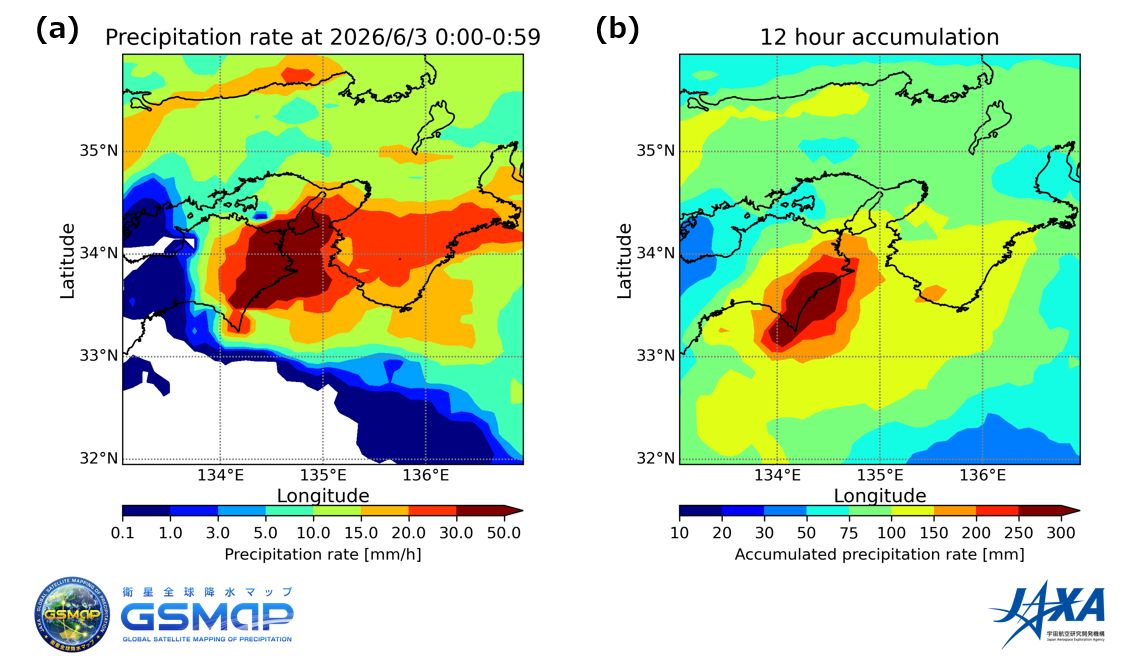
Figure 3 shows the rainfall conditions estimated by GSMaP around the time when quasi-stationary band-shaped precipitation systems occurred in Tokushima and Wakayama Prefectures. Heavy rain exceeding 20 mm/h fell, reaching intense levels of over 30 mm/h in Tokushima Prefecture in particular. The figure also shows that the rain continued for a long period of time.
As a result of the prolonged heavy rainfall, a Level 5 Flood Emergency Warning (the highest alert level) was temporarily issued for the Kozagawa River in Wakayama Prefecture, and a Level 4 Flood Urgent Warning was issued for several rivers in Tokyo. The continued rainfall caused by the typhoon is thought to be the cause of the rapid increase in the river’s water volume.
In addition to satellite observations, JAXA is also conducting research and development to estimate and predict flood risks through numerical simulations that utilize satellite observation data.
One of them is a global terrestrial hydrological simulation system called “Today’s Earth.” JAXA is conducting research and development on “Today’s Earth” in collaboration with the University of Tokyo. In particular, “Today’s Earth – Japan (TE-Japan),” which focuses specifically on Japan region, conducts simulations of terrestrial water cycle based on forecasts of meteorological data such as rainfall, snowfall, temperature, and wind speed, and estimates river discharge, water levels, the percentage of flooded areas and soil moisture in the Japan region at approximately 1 km mesh resolution.
Figure 4 shows the estimated changes in river flow from the early morning of June 2, when Typhoon JANGMI approached Japan, to June 3.
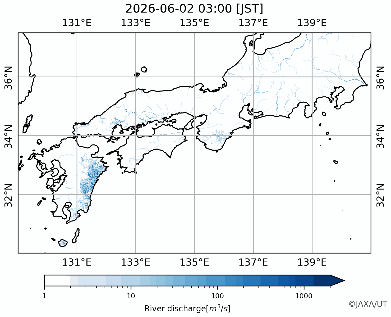
Figure 4 shows that an increase in river discharge is estimated over a wide area along the Pacific coast. It is thought that this increase includes the effects of the quasi-stationary band-shaped precipitation systems. In particular, the increase in river discharge is evident in Miyazaki Prefecture, the Shikoku region and the Kii Peninsula. Reports indicate that river water levels in these areas, including the Kozagawa River in Wakayama Prefecture, have reached flood danger levels, which is consistent with these findings.
■ Typhoon JANGMI passed through the Kanto region (around 2:00 p.m. on June 3)
When Typhoon JANGMI crossed the Japanese archipelago and passed through the Kanto region around 2:00 p.m. on June 3, the EarthCARE satellite (Hakuryu) captured the typhoon clouds from space. Figure 5 shows the vertical cross-sectional structure inside the typhoon clouds as observed by the Cloud Profiling Radar (CPR) onboard EarthCARE. Focusing on the vertical structure of the clouds (radar reflectivity), we can see that a widespread chain of very tall clouds extends to an altitude of approximately 15 km. In particular, the areas shown in red (areas with high radar reflectivity) indicate that the cloud and rain particles are large or numerous.
Furthermore, CPR observes the vertical motion of particles within the cloud (Doppler velocity), including cloud particles and raindrops. At altitudes below 5 km, the values are generally negative (shown in blue), due to the rapid downward movement of the typhoon’s raindrops. In contrast, at altitudes above 5 km, the Doppler velocity values are small, indicating that the particles are falling more slowly.
Examining these observational results collectively, it seems that cloud particles within the Typhoon JANGMI clouds were actively growing and transforming into precipitation, generating rain over a wide area in the typhoon’s lower layers.
The GPM/DPR observation data presented here are used routinely in numerical weather forecasts by JMA and in daily weather forecasts. In addition, EarthCARE observation data are used to verify the reproducibility of typhoons in numerical models. In addition, JAXA/ EORC widely provides rainfall, typhoon, and related hydrological information through “GSMaP,” “Today’s Earth,” “JAXA/EORC Tropical Cyclone Database,” and “JAXA Senjo-Kousuitai Intensive Observation Monitor.” We will continue to provide satellite observation data and numerical simulations as valuable sources of information for making decisions about weather and disaster prevention.
Related Website
JAXA Global Rainfall Watch
JAXA GPM Website
Today’s Earth Japan
JAXA Senjo-Kousuitai Intensive Observation Monitor
JAXA/EORC Tropical Cyclone Database
JAXA/EORC EarthCARE Website
*1. Japan Meteorological Agency (JMA): The intensity and pattern of the rain
https://www.jma.go.jp/jma/kishou/know/yougo_hp/amehyo.html
*2. JMA: Example of quasi-stationary band-shaped precipitation systems
https://www.data.jma.go.jp/senjo_list/list_senjoukousuitai.html
*3. JMA: Level 5 Flood Emergency Warning issued for the Kozagawa River system’s Kozagawa River (Wakayama Prefecture)
https://www.jma.go.jp/jma/press/2606/03a/20260603_hanran_tokukei.html
Search by Year
Search by Categories


Tags
-
#Earthquake
-
#Land
-
#Satellite Data
-
#Aerosol
-
#Public Health
-
#GCOM-C
-
#Sea
-
#Atmosphere
-
#Ice
-
#Today's Earth
-
#Flood
-
#Water Cycle
-
#AW3D
-
#G-Portal
-
#EarthCARE
-
#Volcano
-
#Agriculture
-
#Himawari
-
#GHG
-
#GPM
-
#GOSAT
-
#Simulation
-
#GCOM-W
-
#Drought
-
#Fire
-
#Forest
-
#Cooperation
-
#Precipitation
-
#Typhoon
-
#DPR
-
#NEXRA
-
#ALOS
-
#GSMaP
-
#Climate Change
-
#Carbon Cycle
-
#API
-
#Humanities Sociology
-
#AMSR
-
#Land Use Land Cover
-
#Environmental issues
-
#Quick Report
-
#GOSAT-GW
Related Resources


Related Tags
Latest Observation Related Articles
-
 Latest Observation 2026.04.16 Thu [Quick Report] EarthCARE Captured the Eye of Typhoon Sinlaku
 -
 Latest Observation 2025.12.03 Wed [Quick Report] Analysis results from satellite precipitation data on the record-breaking heavy rainfall occurring in Southeast Asia in late November 2025
 -
 Latest Observation 2025.10.01 Wed [Quick Report] Hurricane Humberto “Eye” captured by EarthCARE satellite (Hakuryu)
 -
 Latest Observation 2025.02.28 Fri The world’s largest iceberg, A23a, may have run aground on the continental shelf of South Georgia:
The trajectory of iceberg A23a observed by “GCOM-W”, “ALOS-2” and “ALOS-4”
Stay Connected
