JAXA’s Efforts to Disaster Management
Japan, which is known as a disaster-prone country, has suffered a great deal of damage from natural phenomena such as typhoons, heavy rains, heavy snowfalls, landslides, earthquakes, tsunamis, and volcanic eruptions. We would like to express our deepest sympathies to all those who have been affected by these natural disasters.
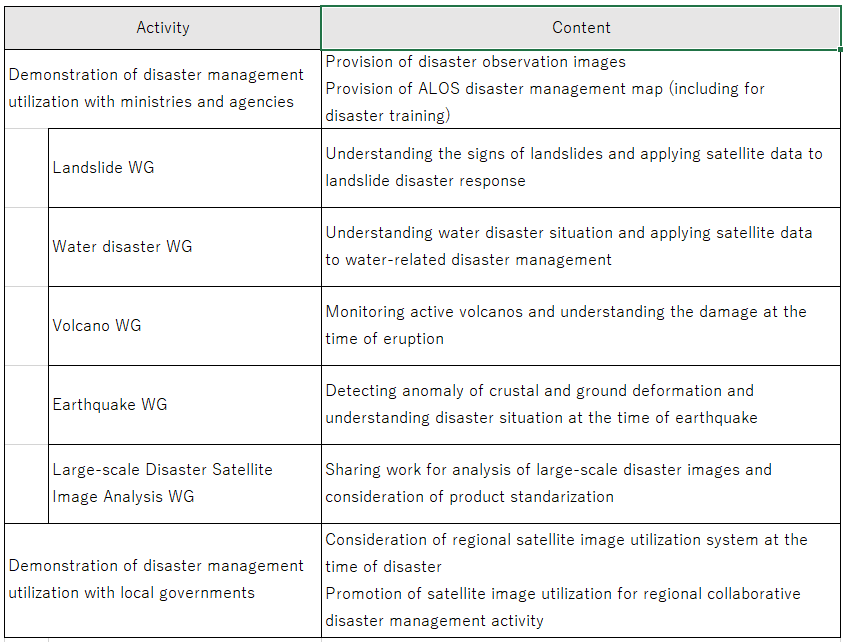
In order to mitigate the damage caused by natural disasters, it is important to understand the damage situation early and quickly. In addition, for some disasters, such as volcanic eruptions, regular monitoring can be expected to prevent damage by detecting signs of disaster. Satellites, such as the Advanced Land Observing Satellite-2 (ALOS-2) of the Japan Aerospace Exploration Agency (JAXA), are capable of periodically observing a wide area. We, JAXA Satellite Applications and Operations Center (SAOC) are working to minimize the impact of natural disasters and build a society in which people can live without anxiety (Table 1).
List 1: Activities for Disaster Management Utilization of Earth Observation Satellites
Cooperation with disaster management organizations
Our activities started in 2006 at the request of the Cabinet Office, the Ministry of Land, Infrastructure, Transport and Tourism, and other disaster management organizations, and we have gradually stepped up our efforts. Currently, we are working in cooperation with the Cabinet Office Designated Government Organizations, the Coordinating Committee for Prediction of Volcanic Eruption, the Coordinating Committee for Earthquake Prediction, local public entities, and other disaster management organizations (Figure 1).
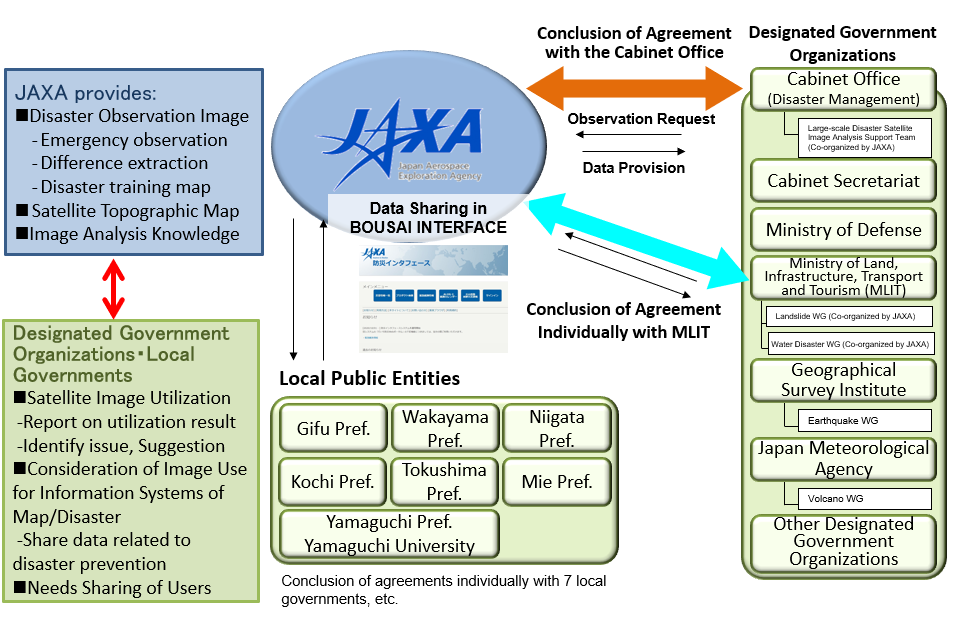
Figure 1: Cooperation with government and local public agencies
In addition to emergency observations during disasters, we hold regular meetings with disaster management organizations to share information on current issues and user needs, such as how to improve satellite observation plans and how to use satellite data for disaster management. As a result, we are able to quickly provide more advanced information from satellite data to more effectively support the response by disaster management organizations. We will also reflect this information in our study of new Earth observation satellites, such as ALOS series.
Emergency observations by Earth observation satellites
In the event of a natural disaster, we conduct emergency observations using Earth observation satellites, such as ALOS-2, at the request of cooperating disaster management organizations. The observed data and information on affected areas are provided to disaster management organizations for use in disaster management and mitigation activities such as damage detection.
JAXA has developed the website “BOUSAI INTERFACE” to share satellite data with disaster management organizations, and started its operation in September 2020 (Figure 2). This system provides a one-stop service to accept requests for emergency observations and products from domestic and international organizations engaged in disaster management and response, and to provide various products generated from optical and radar observation data.
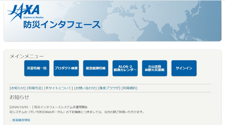
Figure 2: Website of “BOUSAI INTERFACE”
JAXA conducts not only emergency responses when disasters occur, but also monitoring to prevent damage from spreading after a disaster. For example, when a natural dam (a river channel is blocked by a large amount of sediment) due to heavy rains is found, large-scale debris flows are estimated when the dam breaks. In order to prevent such secondary disasters, we continue to conduct observations after disasters and provide information to disaster management organizations.
Major responses by emergency observations for domestic disaster
The Great East Japan Earthquake in March 2011 (Japanese only)
The Kanto-Tohoku Heavy Rainfall in September 2015
The Kumamoto Earthquake in April 2016
The Heavy Rain Event of July 2018
The Heavy Rain Event by Typhoon Hagibis in October 2019
The Heavy Rain Disaster in July of Reiwa in July 2020
Read about the overview of JAXA’s response to each disaster based on the main observation cases in the past.
Regular observations during normal times
While predicting earthquakes is considered to be very difficult, for example, volcanic eruptions can be predicted to some extent through by observations. JAXA is examining and demonstrating the effectiveness of Earth observation satellite data through data provision and R&D not only for emergency response to disasters, but also for monitoring crustal movement and active volcanoes during normal times.
The advantages of regular satellite observations compared to ground-based instruments are to be able to get the following information:
・A wide range of comprehensive information
・ Information on volcano which is difficult to observe from the ground including remote islands and submarine volcanoes, and which cannot be observed with ground-based instruments due to eruption.
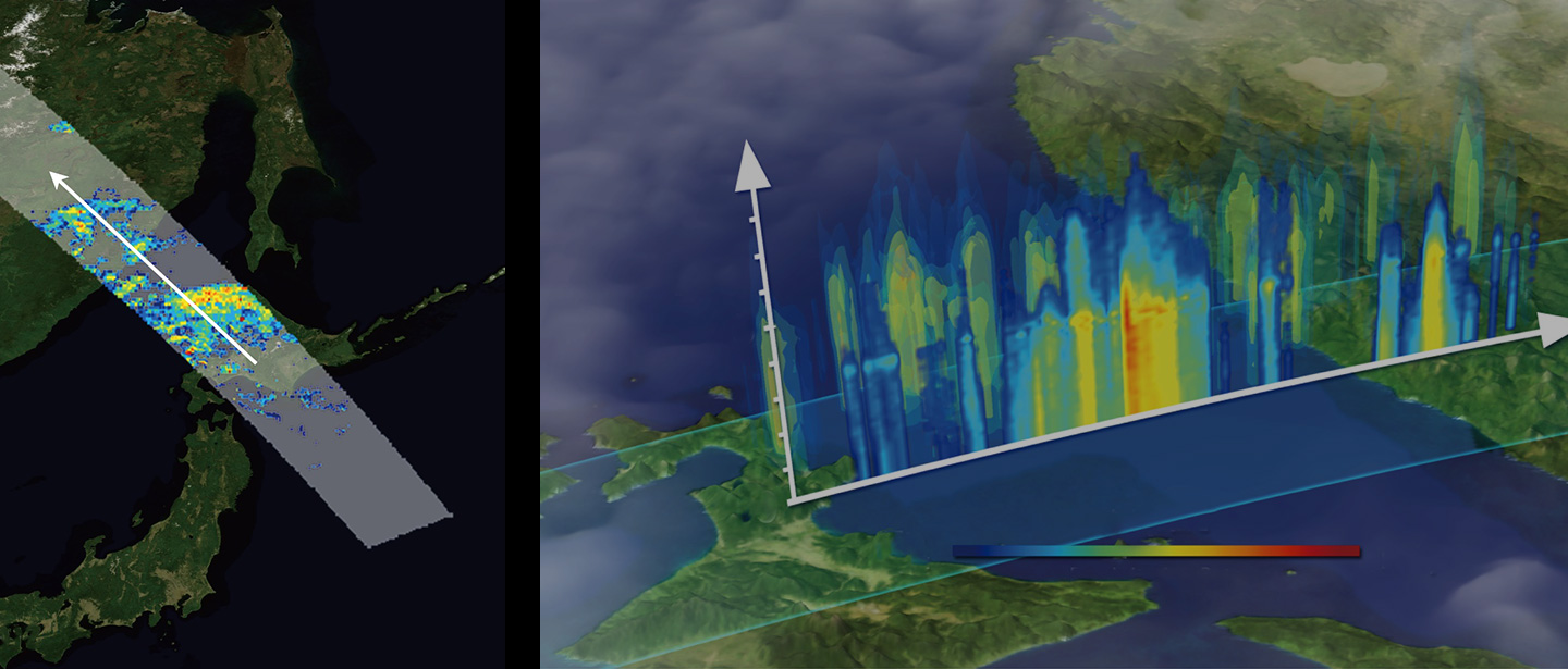
・Information on the ground surface near craters, even in bad weather or when it is covered by volcanic smoke using Synthetic Aperture Radar (SAR) aboard ALOS-2.
Examples of regular observation for volcano
Observation of Nishinoshima in the Ogasawara Islands by ALOS-2
International Frameworks for Disaster Management
In the event of a natural disaster not only in Japan but also overseas, JAXA conducts emergency observations at the request of disaster management organizations in the affected countries, and provides satellite data and analysis results of the disaster situation. JAXA is a member of the international frameworks for disaster management “Sentinel Asia” and “International Charter on ‘Space and Major Disasters’, and is engaged in the activities to make our data available to the world for disaster management and mitigation. Especially in Sentinel Asia, JAXA plays a central role as the executive secretariat and leads the activities in the Asia Pacific region.
Major international disaster management activities
The Nepal Earthquake in April 2015
The West Bhutan Glacial Lake Outburst Flood in June 2016
The Myanmar Heavy Rain in July 2016
The U.S. Hurricane Heavy Rain in September 2017
The Taiwan Earthquake in February 2018
The Laos Flood in July 2018
The Myanmar Flood in August 2018
The Indonesia Earthquake in September 2018
The Philippine Volcanic Eruption in January 2020
The Cooperation for the oil spill incident in Mauritius coast by “ALOS-2” observation in August 2020