


Latest Observation
2025.02.28 Fri
The world’s largest iceberg, A23a, may have run aground on the continental shelf of South Georgia:
The trajectory of iceberg A23a observed by “GCOM-W”, “ALOS-2” and “ALOS-4”
“A23a” is the world’s largest iceberg, measuring approximately 3,300 km2 as of February 5, 2025. It has been drifting away from the Antarctic ice sheet and is rapidly approaching the South Georgia Island. There is concern that if iceberg A23a runs aground on an island, wildlife such as seals and penguins may become isolated from their usual feeding grounds. In 1986, iceberg A23a broke off from the Filchner-Ronne ice shelf, the second largest ice shelf in Antarctica, and remained stranded on the ocean floor in the Weddell Sea for over 30 years. Around 2020, it broke free from the ocean floor and started to drift*1.
The Advanced Microwave Scanning Radiometer 2 (AMSR2) on board JAXA’s GCOM-W has a relatively low resolution of several kilometers to several tens of kilometers, making it unsuitable for monitoring small icebergs. However, its wide coverage and frequent observations allow for rough estimates of the location and shape of large icebergs, such as A23a, at approximately half-day intervals. In contrast, the phased array type L-band synthetic aperture radars (PALSAR-2, PALSAR-3) on board ALOS-2 and ALOS-4 observe less frequently, but have a high resolution of several meters to several tens of meters, allowing the observation of detailed features such as the iceberg area and cracks. Since GCOM-W, ALOS-2 and ALOS-4 using microwave can observe the Earth’s surface globally regardless of cloud cover or darkness, they are suitable tools for continuously monitoring the dynamics of iceberg A23a.
Figure 1(a) shows the results of tracking the movement of iceberg A23a using AMSR2 data at semi-monthly intervals since January 2022. We can see that iceberg A23a drifted northwest across the Weddell Sea along the Antarctic continental shelf slope for about two years, and then shifted northeastward on the Antarctic Circumpolar Current. Figure 1(b) shows the results of tracking the iceberg’s movement every two days since January 2025. After the approach of the A23a iceberg to South Georgia Island was reported in the media in mid-January, it had been moving westward for a while. However, between mid-February and February 26, it rapidly approached the island and finally entered the continental shelf. The depth of the continental shelf under iceberg A23a is about 200 m at the shallowest part. Considering that the average thickness of iceberg A23a is just over 280m*2, a collision with the continental shelf likely occurred. Iceberg A23a reached the continental shelf on February 25, and three AMSR2 observations from February 26 indicate that the iceberg has been rotating counterclockwise while its northward movement has halted. It is necessary to closely monitor the movements of iceberg A23a to see whether it will run aground completely or begin to move again.
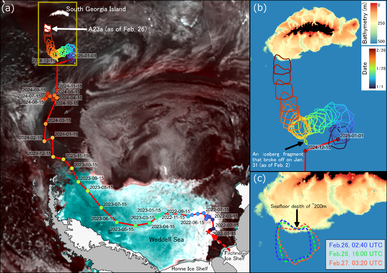
The AMSR2 observations also captured iceberg fragments resulting from the first large-scale collapse of iceberg A23a on January 31. However, in order to accurately understand the detailed collapse process and structural changes of the A23a iceberg, higher-resolution satellite observations are essential. Next, we will introduce detailed images of the iceberg captured by ALOS-2 and ALOS-4 observations.
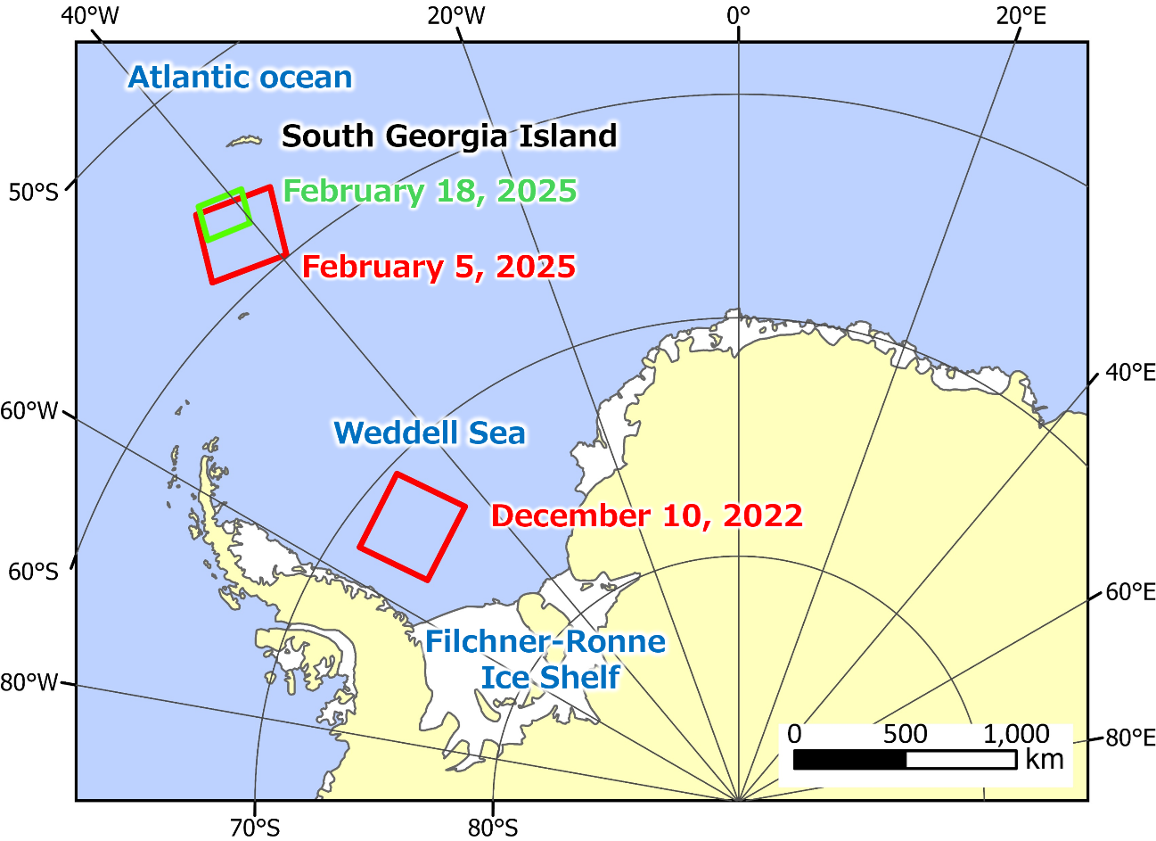
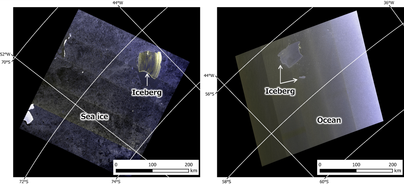
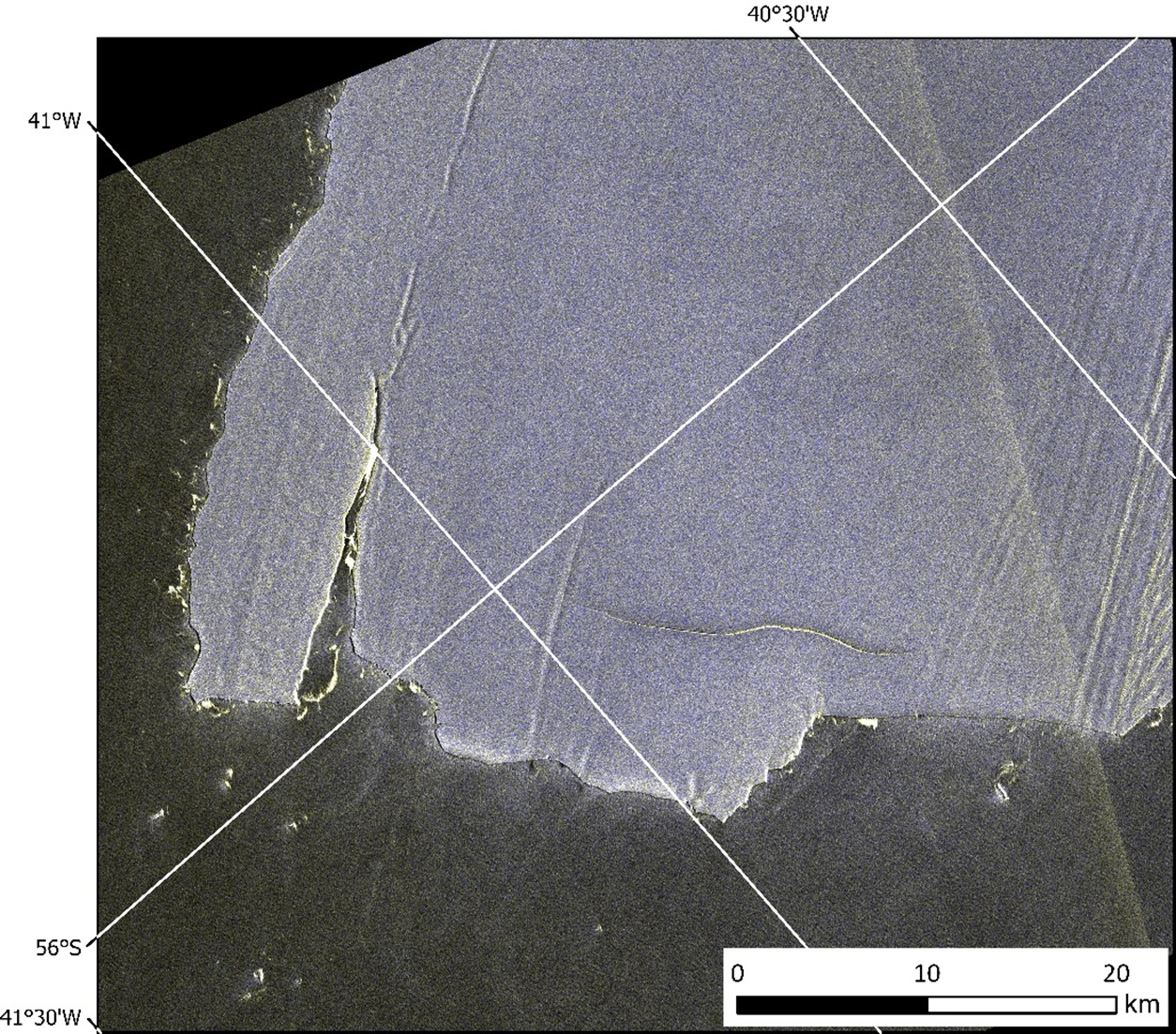
Figure 2 shows the observation area of ALOS-2 and ALOS-4. Figure 3 shows images captured by ALOS-2 in ScanSAR mode (resolution 100 m, width 350 km). As of December 10, 2022, A23a was drifting in the Weddell Sea, surrounded by sea ice (shown in gray). In contrast, by February 5, 2025, the iceberg had moved north, escaping the sea ice area. In addition, the collapse of the iceberg was confirmed on February 5, 2025. As a result, the size of the iceberg, which was approximately 4,000 km2 on December 10, 2022, was reduced to approximately 3,300 km2. Figure 4 is an image captured by ALOS-4 in Stripmap mode (resolution 3m, width 200km). As demonstrated by the comparison of Figures 3 and 4, the ALOS-4 image provides a more detailed view because of its higher spatial resolution. Figure 4 shows that the iceberg is gradually collapsing from its edge. Monitoring the area and cracks is important for predicting changes in A23a.
By utilizing the strengths of GCOM-W, ALOS-2, and ALOS-4, which use microwaves, we can observe changes in snow and ice in the Antarctic region, where in-situ observations are extremely difficult. JAXA plans to continue observing the area with GCOM-W, ALOS-2 and ALOS-4.
Reference:
*1. BBC News, World’s biggest iceberg heads north after escaping vortex. December 15, 2024.
https://www.bbc.com/news/articles/cg4zve79z5ro
*2. BBC News, A23a: Monster iceberg just shy of a trillion tonnes. December 14, 2023.
https://www.bbc.com/news/science-environment-67694164
Search by Year
Search by Categories


Tags
-
#Earthquake
-
#Land
-
#Satellite Data
-
#Aerosol
-
#Public Health
-
#GCOM-C
-
#Sea
-
#Atmosphere
-
#Ice
-
#Today's Earth
-
#Flood
-
#Water Cycle
-
#AW3D
-
#G-Portal
-
#EarthCARE
-
#Volcano
-
#Agriculture
-
#Himawari
-
#GHG
-
#GPM
-
#GOSAT
-
#Simulation
-
#GCOM-W
-
#Drought
-
#Fire
-
#Forest
-
#Cooperation
-
#Precipitation
-
#Typhoon
-
#DPR
-
#NEXRA
-
#ALOS
-
#GSMaP
-
#Climate Change
-
#Carbon Cycle
-
#API
-
#Humanities Sociology
-
#AMSR
-
#Land Use Land Cover
-
#Environmental issues
-
#Quick Report
-
#GOSAT-GW
Related Resources


Related Tags
Latest Observation Related Articles
-
 Latest Observation 2026.06.05 Fri [Quick Report] Typhoon No. 6, “JANGMI”, brought heavy rain to Japan. – Results of satellite data analysis –
 -
 Latest Observation 2026.04.16 Thu [Quick Report] EarthCARE Captured the Eye of Typhoon Sinlaku
 -
 Latest Observation 2025.12.03 Wed [Quick Report] Analysis results from satellite precipitation data on the record-breaking heavy rainfall occurring in Southeast Asia in late November 2025
 -
 Latest Observation 2025.10.01 Wed [Quick Report] Hurricane Humberto “Eye” captured by EarthCARE satellite (Hakuryu)
Stay Connected
