


Types of Earth observation satellites
Types of Earth observation satellites
Earth observation satellites are the satellites which observe various phenomena happened on the Earth from space. The equipped sensors are different depending on the purpose such as observation of natural phenomenon, disaster monitoring, changes in the Earth caused by human activity and so on. There are many satellites all over the world including Japan.
Observation results are provided as satellite images or observation data, and can be interpreted into various information regarding the Earth. They are effectively utilized for monitoring global environmental change and the research to clarify its process.
What the satellite data shows differs depending on the equipped sensor. Sensors are broadly classified as two types, optical sensor and microwave sensor. Here are some examples. (①②③ are optical sensors and ④⑤ are microwave sensors.)
① Visible and near-infrared sensors can identify the quantity and the type of the object by mainly capturing visible light and near-infrared waves of the object reflecting sunlight. So, it is not feasible to observe under the clouds or during night-time. Mainly, we can find information of earth’s surface such as distribution of vegetation/urban areas and color of oceans, etc.
② Thermal infrared sensor captures thermal infrared waves emitted from objects which are warmed up by sunlight. It is possible to observe Earth’s surface even at night-time if there are no clouds. Mainly, we can find temperatures of land and sea surface, condition of volcano activities and wildfires, etc.
③ Lidar can precisely measure the distance to the object and its condition by emitting light of visible to near-infrared range and measuring the strength and time to reflect back from the object and change of the wavelength. Mainly, we can find tree height in the forest, ice sheet thickness, wind speed, etc.
④ SAR emits microwaves to the object and can catch the condition of the earth’s surface by the intensity and phase of its reflected wave. Microwaves pass through clouds, so the target can be observed regardless of day and night or weather conditions. Mainly, we can find topographical change by volcano and seismic activity, condition of deforestation, inundated area and movement of ships, etc.
⑤ Microwave radiometer can observe geophysical quantities to assess water and energy cycles day and night, regardless of weather conditions by capturing microwaves naturally emitted from the earth’s surface and the atmosphere. Mainly, we can find the condition such as sea surface temperature, water vapor content in the atmosphere, amount of precipitation, distribution of sea ice, snow cover thickness, etc.
Orbits of Earth observation satellites
An orbit is a path that various satellites including Earth observation satellites use when flying around the Earth. There are some types of orbits and which orbit the satellite flies in is determined by the purpose of each satellite.
Mainly, Earth observation satellites use a synchronous sub-recurrent orbit, a type of polar orbit (orbit which passes over polar regions). A synchronous sub-recurrent orbit is a combination of a sun-synchronous orbit (the angle between an orbit plane and the Sun seen from the Earth is always constant/flying at the same local solar time) and sub-recurrent orbit (flying at the same local solar time and the same location at a fixed period).
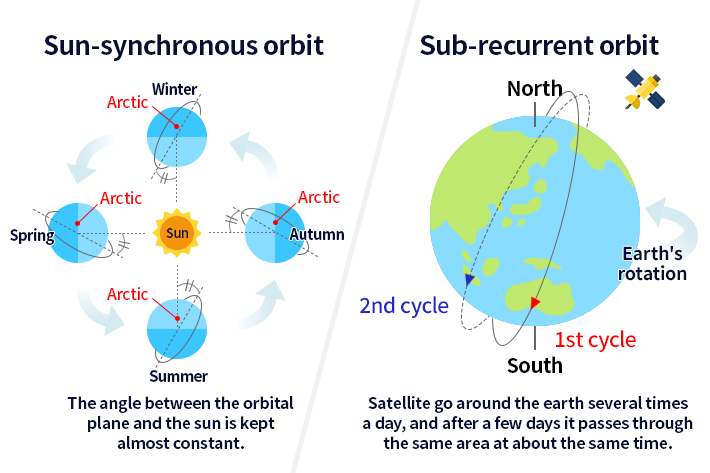
When satellites fly in a synchronous sub-recurrent orbit, incidence angle of sunlight on the earth’s surface during observation is almost constant. So, amount of radiation and reflection from the earth’s surface can be observed relatively equally and it is possible to observe the same area at fixed intervals. The cycle; a time for an Earth observation satellite to circle the globe and the revisit time; a days in which the satellite passes the same place differ depending on the altitude and the inclination angle of the orbit.
Also, geostationary orbit is an orbit that always keeps a constant relative relationship with the rotating Earth. So, the satellite always views the same place on the Earth. Mainly, weather satellite (Himawari), broadcasting satellite and communication satellite use this orbit.
Resolution of Earth observation satellites
Resolution is a word which shows to what extent the sensors onboard Earth observation satellites can distinguish objects on the ground. Higher resolution is good at observing details on the ground. Resolution is also called “spatial resolution”.
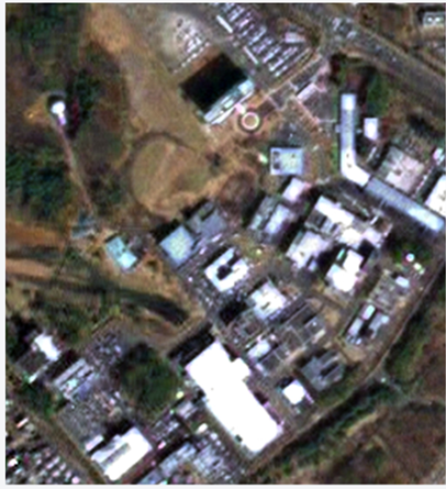
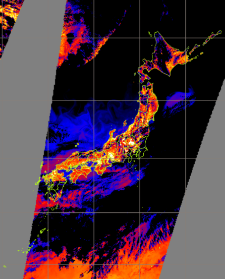
Following two types of satellite images are observation results of the same area using by different sensors. We can find the difference in vision depending on the resolution and features of the sensors.
Visible images around Tsukuba Space Center
 |
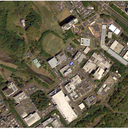 |
| Satellite/Sensor:ALOS/ PRISM Resolution:2.5m |
Satellite/Sensor:ALOS-3/Wide-swath and High-resolution Optical Imager Resolution:0.8m (Simulation image) |
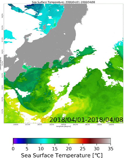
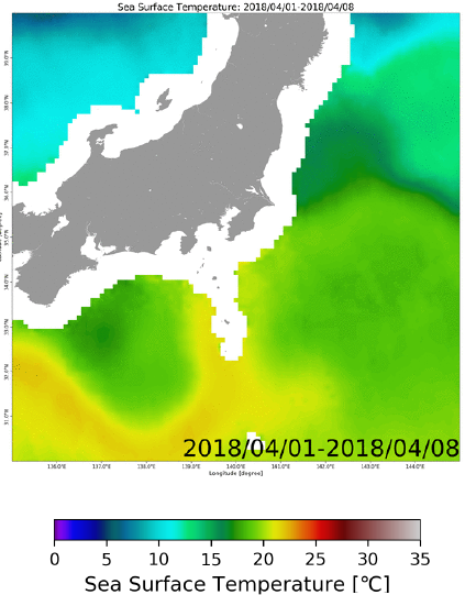
Images of Sea Surface Temperature (8 days average)
 |
 |
| Satellite/Sensor:GCOM-C/SGLI Resolution:250m High resolution, but precise observation is not possible under clouds |
Satellite/Sensor:GCOM-W/ AMSR2 Resolution:50km Low resolution, but observation is possible except heavy rain |
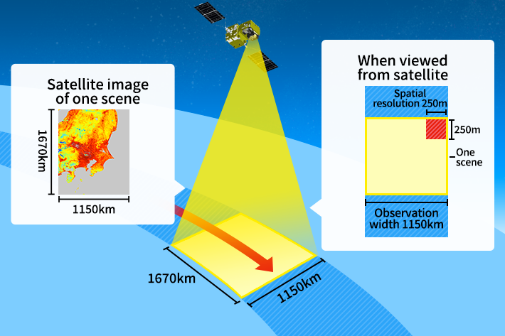
Observation width of Earth observation satellites
In many cases, observation width means a range that equipped sensors on Earth observation satellites can observe (width in a direction perpendicular to the orbit). It is also called “swath”. Since the satellites zonally observe the range of swath along the orbit, the images are provided by clipping into convenient size (called “scene”). The swath and the size of one scene of satellite image are different depending on the types of sensors.
For example, let’s compare the visible image and the thermal infrared image captured by Global Change Observation Mission – Climate “SHIKISAI” (GCOM-C). Swath of the visible sensor is 1150km and that of the thermal infrared sensor is 1400km (Nagasaki prefecture is included in observation range in case of the thermal infrared image). We can see the difference of swath etc. depending on the onboard sensor even in the same satellite.
Difference of swath by the sensor onboard GCOM-C on the same day
 |
 |
| Visible image Satellite/Sensor:GCOM-C/SGLI-VNR Swath:1150km |
Thermal infrared image Satellite/Sensor:GCOM-C/SGLI-IRS Swath:1400km |
What we can find from Earth observation satellite data
Typical information we can find from JAXA Earth observation satellite data is as follows.
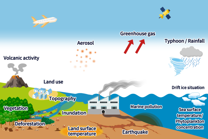
・Aerosol
The data is utilized for aerosol forecast including yellow dust, PM2.5 etc. and for accuracy improvement of global warming prediction model.
・Greenhouse gas
Greenhouse gases in the atmosphere are globally observed. The data is utilized for understanding of dynamics of greenhouse gases and estimation of human-induced CO2 emission amount.
・Typhoon and rainfall
The data is utilized for provision of information related with weather, such as strength of rainfall, condition of typhoon and distribution of water vapor content in the atmosphere causing rainfall. The data is also useful to clarify global climate change.
・Marine pollution
We can see distribution condition of marine pollution caused by oil spill etc.
・Drift ice situation
We can see distribution of drift ice and its movement.
・Sea surface temperature and phytoplankton density
The data is utilized for monitoring ocean environment, clarification of fluctuation process and prediction of fishery.
・Earthquake
The data is utilized for anomaly detection of crustal variation and ground deformation, clarification of mechanism of earthquake occurrence, assessing damage situation in natural disasters.
・Inundation
The data is utilized for estimation of inundated area caused by flood and tsunami, assessing flood condition and disaster prevention activity.
・Volcano activity
The data is utilized for monitoring active volcano and assessing damage situation at the time of eruption.
・Deforestation
By using SAR, it is possible to observe penetrating clouds even in the tropics which have many clouds. The data is utilized for detecting deforestation.
・Land use
We can see how the land is used such as urban area, forest, farmland and so on.
・Vegetation
We can see distribution and change of forest, grassland etc. and know the information of forest resources.
・Topography
We can confirm complex landform, characteristic mountain range, ruins etc.
・Land surface temperature
We can see seasonal and day-and-night variations of land surface temperature. At the same time, the data is utilized as environmental information related to ecosystem.


Stay Connected
