


Latest Observation
2025.10.01 Wed
[Quick Report] Hurricane Humberto “Eye” captured by EarthCARE satellite (Hakuryu)
Hurricane Humberto, which developed off the U.S. East Coast, reached its peak strength on September 27, 2025, intensifying into a powerful Category 5 storm – the highest level on the scale. Meanwhile, another hurricane, Imelda, was tracking just a few hundred kilometers to the west of Humberto. Together, the two storms are expected to generate large waves across much of the US East Coast, including areas around Bermuda and the Bahamas, with rough surf likely to continue through the rest of the week.
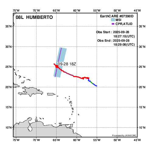
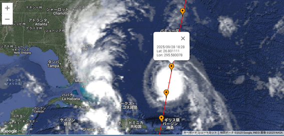
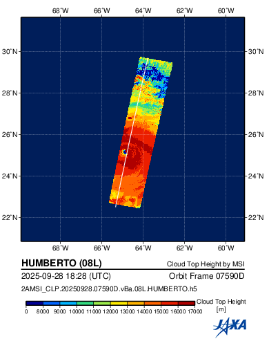
The Earth Cloud Aerosol and Radiation Explorer (EarthCARE) satellite, jointly developed with the European Space Agency (ESA) and also known by its Japanese nickname Hakuryu (“White Dragon”), observed Hurricane Humberto as it moved northeast off the U.S. East Coast on 28 September 2025. Figure 1 shows the observation, with panel (a) illustrating the hurricane’s track along with EarthCARE’s observation area, and panel (b) presenting the geostationary GOES satellite image taken at nearly the same time. EarthCARE’s orbit is indicated by the purple line, and the corresponding observation data are displayed in panels (c), (d), and (e).
(a)Track of Hurricane Humberto and the observation area of EarthCARE
(b)Cloud distribution by NOAA/GOES and the trajectory of EarthCARE. Cloud image ©JAXA/NOAA, map data © Google, background image © NASA.
(c)EarthCARE (CPR) radar reflectivity

(d)EarthCARE (CPR) Doppler velocity

(e)EarthCARE (ATLID) cloud backscatter coefficient

(f)EarthCARE (MSI) estimated cloud top height
(g)3-D video
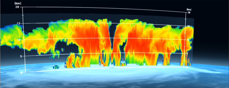
Figure 1: EarthCARE observations of Hurricane Humberto at 18UTC on 28 September 2025
The radar reflectivity from the Cloud Profiling Radar (CPR) shown in Figure 1(c) represents a vertical cross-section of Hurricane Humberto. Areas with high reflectivity (in red) indicate regions where cloud or rain particles are large or numerous. This hurricane, which extends more than 500 km horizontally, has developed up to an altitude exceeding 16 km, showing it to be a very thick cumulonimbus cloud system. Also, near 25°N latitude (marked as “Hurricane Eye” in the figure), a clear region without clouds can be seen contrast to the surrounding thick walls – this is the so-called “eye” of the hurricane. Panel (e) shows the observations from the Atmospheric Lidar (ATLID), which detected thin cloud layer above the altitude ranged observed by the CPR. At the same time, the hurricane’s “eye” is distinctively visible in the ATLID data as well, demonstrating that by combining CPR and ATLID observations, the structure of the hurricane can be understood in more detail.
The CPR Doppler velocity data shown in Figure 1(d) illustrates the vertical motion of cloud and rain particles. Below an altitude of 5 km, the values are largely negative (blue), indicating particles are falling – meaning that heavy rainfall is occurring in the lower layers of the hurricane. Above 5 km, however, the Doppler velocities are smaller, showing snow particles are either floating gently or falling slowly. This suggests that around the 5 km level, snow is melting into rain, after which raindrops fall rapidly. Around the wall surrounding the hurricane’s “eye” near 25°N, localized red regions indicate strongly positive Doppler velocities, indicating cloud particles being rapidly lifted upwards. It is well known that strong updrafts exist around the eye of a hurricane, and this observation directly captured that phenomenon. Such updrafts, together with downdrafts that occurring the center of the eye, are believed to be closely related to the intensity (development and weakening) of hurricanes and typhoons. While hurricane and typhoon eyes have been observed before by satellites including geostationary weather satellites, the EarthCARE satellite successfully observed vertically detailed structures of the hurricane along with the falling and rising movements of internal cloud droplets and raindrops.
In particular, since the CPR and ATLID onboard the EarthCARE satellite can only observe directly beneath the satellite, the case where it passed straight over the center of a hurricane was exceptionally rare. This fortunate alignment provided a valuable set of observations that, together with the EarthCARE’s other measurements, will serve as an important resource for future studies of hurricanes and typhoons.
From 1 October 2025, the “JAXA/EORC Typhoon Database” website (JAXA News article) released newly added observation image of EarthCARE – such as cross-sections of clouds and typhoons. By accumulating observation cases of hurricanes and typhoons like those introduced this time, EarthCARE is expected to advance our understanding of hurricane and typhoon mechanisms and improving prediction accuracy in the future.
Search by Year
Search by Categories


Tags
-
#Earthquake
-
#Land
-
#Satellite Data
-
#Aerosol
-
#Public Health
-
#GCOM-C
-
#Sea
-
#Atmosphere
-
#Ice
-
#Today's Earth
-
#Flood
-
#Water Cycle
-
#AW3D
-
#G-Portal
-
#EarthCARE
-
#Volcano
-
#Agriculture
-
#Himawari
-
#GHG
-
#GPM
-
#GOSAT
-
#Simulation
-
#GCOM-W
-
#Drought
-
#Fire
-
#Forest
-
#Cooperation
-
#Precipitation
-
#Typhoon
-
#DPR
-
#NEXRA
-
#ALOS
-
#GSMaP
-
#Climate Change
-
#Carbon Cycle
-
#API
-
#Humanities Sociology
-
#AMSR
-
#Land Use Land Cover
-
#Environmental issues
-
#Quick Report
-
#GOSAT-GW
Related Resources


Related Tags
Latest Observation Related Articles
-
 Latest Observation 2026.06.05 Fri [Quick Report] Typhoon No. 6, “JANGMI”, brought heavy rain to Japan. – Results of satellite data analysis –
 -
 Latest Observation 2026.04.16 Thu [Quick Report] EarthCARE Captured the Eye of Typhoon Sinlaku
 -
 Latest Observation 2025.12.03 Wed [Quick Report] Analysis results from satellite precipitation data on the record-breaking heavy rainfall occurring in Southeast Asia in late November 2025
 -
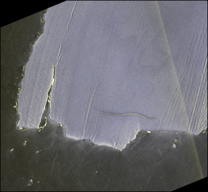 Latest Observation 2025.02.28 Fri The world’s largest iceberg, A23a, may have run aground on the continental shelf of South Georgia:
The trajectory of iceberg A23a observed by “GCOM-W”, “ALOS-2” and “ALOS-4”
Stay Connected
