


Latest Observation
2026.04.16 Thu
[Quick Report] EarthCARE Captured the Eye of Typhoon Sinlaku
The EarthCARE satellite (Japanese name: Hakuryu) successfully passed directly over the eye of Typhoon Sinlaku (Typhoon No.4 in 2026) on 13 April 2026, capturing unprecedented observations of the typhoon’s internal cloud structure. This rare overpass enabled detailed measurements of the vertical dynamics within the storm’s clouds.
Click to play.
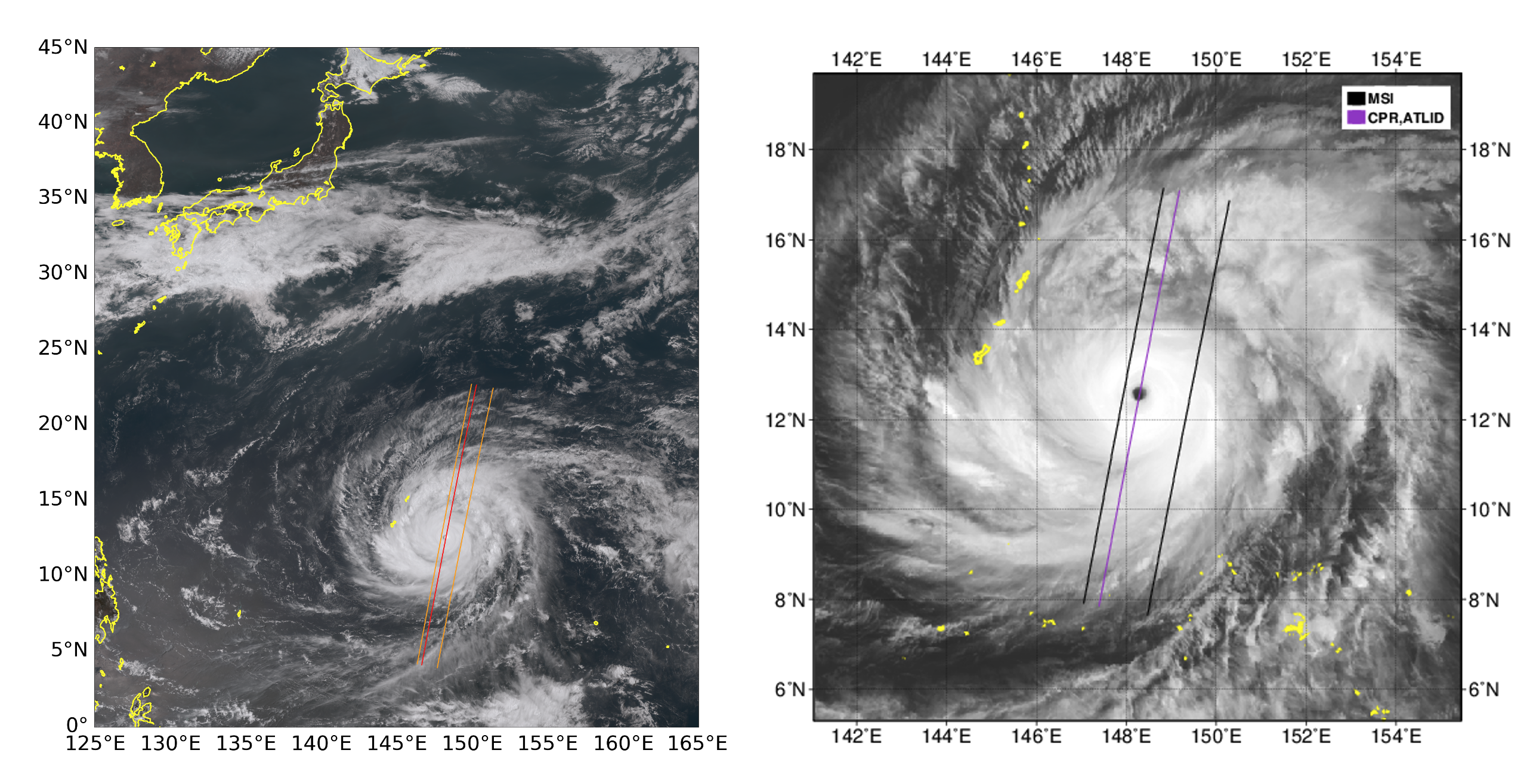
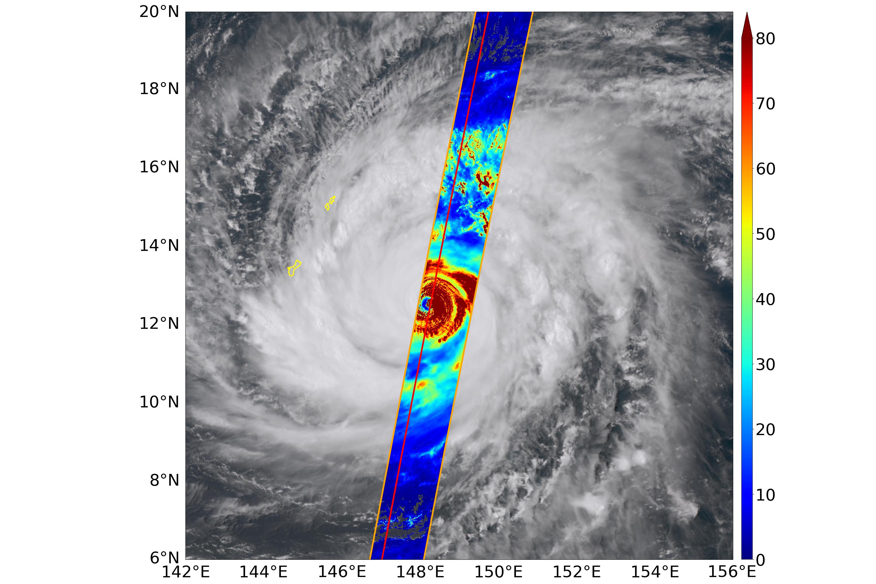
As of 14 April, Typhoon Sinlaku was intensifying significantly while moving north-northwestward near the Mariana Islands. The EarthCARE satellite, jointly developed by JAXA and the European Space Agency (ESA), passed directly over the well-developed eye of the storm, allowing direct observation of its internal structure from space. A cloud distribution image from the Himawari-9 geostationary satellite (Figure 1) shows that the typhoon was located southeast of Japan at the time of observation, with a clearly defined eye surrounded by dense eyewall clouds. By overlaying the cloud distribution observed by EarthCARE’s Multi-spectral Imager (MSI) on the Himawari imagery (Figure 2), the cloud optical thickness estimated from MSI clearly shows thick clouds near the typhoon’s eye.
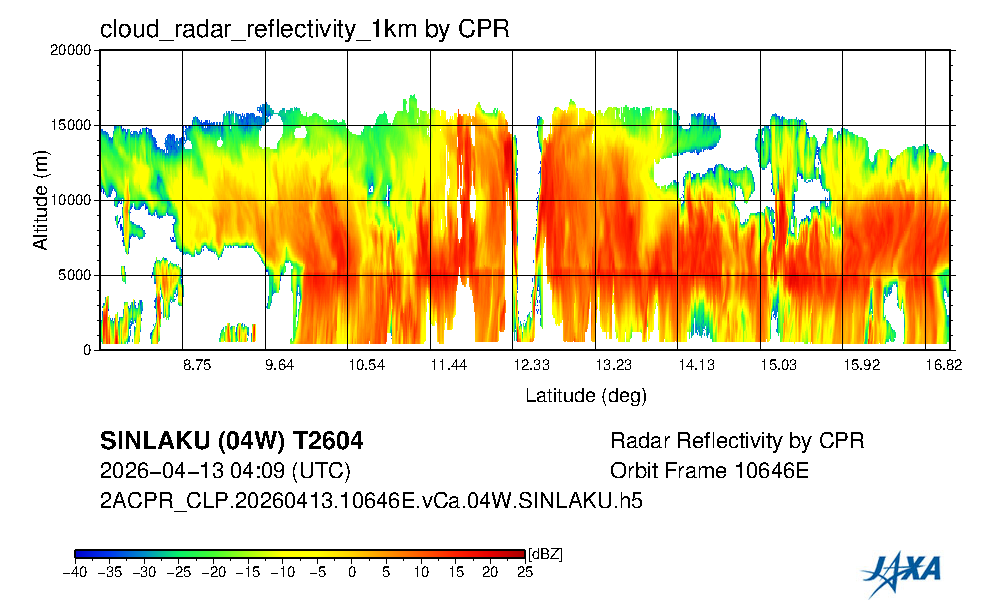
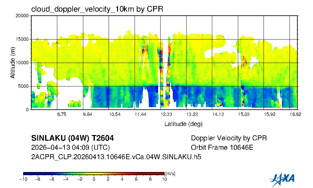
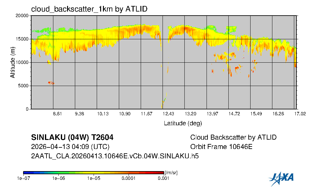
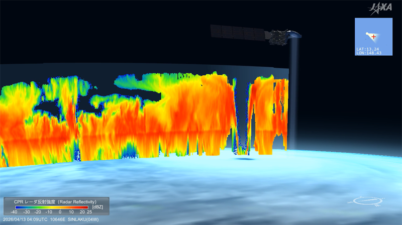
Vertical cross-sections from EarthCARE’s Cloud Profiling Radar (CPR) observation reveal the internal cloud structure of Typhoon Sinlaku (Figures 3 and 4). Extensive cloud systems reaching altitudes above 15 km spread widely throughout the storm. Near latitude 12.33°, a distinct cloud‑free hollow region is evident, corresponding to the eye of the typhoon. Regions of high radar reflectivity indicate large and/or densely distributed cloud and precipitation particles, forming thick eyewall clouds on both sides of the eye. Synergistic observations by the Atmospheric Lidar (ATLID) onboard EarthCARE provide complementary information on thin cloud layers that are difficult to detect with CPR (Figure 5). Although lidar signals are attenuated in the lower parts of the typhoon, ATLID observation clearly show thin clouds spreading above the storm. Cloud top height near the typhoon’s eye is extremely tall, reaching approximately 17–18 km.
The Doppler velocities observed by the CPR illustrate the vertical motion of cloud particles and raindrops within the typhoon clouds (Figure 4). Below 5 km, the Doppler velocities are predominantly negative (shown in blue), identifying the fast downward motion of raindrops. Above 5 km, the Doppler velocity values are generally small, suggesting that snow particles are either gently drifting or falling slowly. The Doppler velocities around the eyewall cloud fluctuate between positive and negative values. CPR observations have a limited measurable velocity range, and when the actual particle velocity exceeds the maximum observable value (the Nyquist velocity, approximately ±5 m/s), the Doppler velocity folding occurs, in which the motion is displayed as having a reversed or different velocity. Strong updrafts are generally expected within a typhoon’s eyewall, and the fluctuating positive and negative values of the Doppler velocity observed in Figure 4 are therefore interpreted as existence of cloud particles moving at very large velocities that exceed the Nyquist limit.
Remarkable feature of Hakuryu is ability to observe not only the vertical structure of typhoon, but also the detailed internal dynamics such as upward and downward motion of a typhoon from space. Direct overpass of the center of a well‑developed typhoon, as in this case, is an extremely rare opportunity. This observation therefore represents a particularly valuable case that contributes to advancing the scientific understanding of typhoon structure and behavior.
JAXA Earth Observation Research Center (EORC) operates the JAXA/EORC Typhoon Database website, which automatically generates and publishes three‑dimensional cloud videos using observation data from EarthCARE. The website also provides images and videos of typhoons observed by various JAXA Earth observation satellites. Newly generated typhoon images and videos will continue to be released on the website as they become available.
- JAXA/EORC Typhoon Database
https://sharaku.eorc.jaxa.jp/TYP_DB/index.html
Search by Year
Search by Categories


Tags
-
#Earthquake
-
#Land
-
#Satellite Data
-
#Aerosol
-
#Public Health
-
#GCOM-C
-
#Sea
-
#Atmosphere
-
#Ice
-
#Today's Earth
-
#Flood
-
#Water Cycle
-
#AW3D
-
#G-Portal
-
#EarthCARE
-
#Volcano
-
#Agriculture
-
#Himawari
-
#GHG
-
#GPM
-
#GOSAT
-
#Simulation
-
#GCOM-W
-
#Drought
-
#Fire
-
#Forest
-
#Cooperation
-
#Precipitation
-
#Typhoon
-
#DPR
-
#NEXRA
-
#ALOS
-
#GSMaP
-
#Climate Change
-
#Carbon Cycle
-
#API
-
#Humanities Sociology
-
#AMSR
-
#Land Use Land Cover
-
#Environmental issues
-
#Quick Report
-
#GOSAT-GW
Related Resources


Related Tags
Latest Observation Related Articles
-
 Latest Observation 2026.06.05 Fri [Quick Report] Typhoon No. 6, “JANGMI”, brought heavy rain to Japan. – Results of satellite data analysis –
 -
 Latest Observation 2025.12.03 Wed [Quick Report] Analysis results from satellite precipitation data on the record-breaking heavy rainfall occurring in Southeast Asia in late November 2025
 -
 Latest Observation 2025.10.01 Wed [Quick Report] Hurricane Humberto “Eye” captured by EarthCARE satellite (Hakuryu)
 -
 Latest Observation 2025.02.28 Fri The world’s largest iceberg, A23a, may have run aground on the continental shelf of South Georgia:
The trajectory of iceberg A23a observed by “GCOM-W”, “ALOS-2” and “ALOS-4”
Stay Connected
