


Disaster
2023.03.31 Fri
ALOS-2 observation: Oil spill from sunken oil tanker off Mindoro Island, Philippines
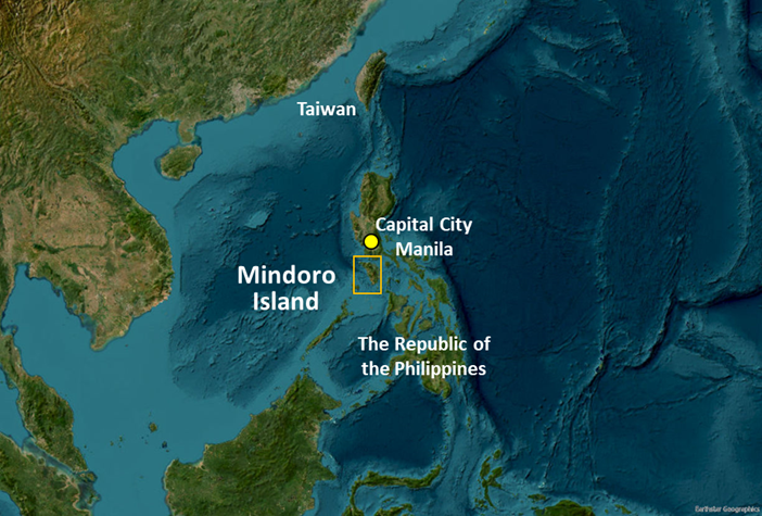
A Philippine oil tanker “MT Princess Empress” sank off the coast of Mindoro Island in the Republic of the Philippines on March 1, 2023 (Japan Standard Time), and its cargo of approximately 800 tons of industrial fuel oil leaked into the water in the area. In response to this incident, the Japan Disaster Relief (JDR) Expert Team was dispatched for gathering information on the oil spill situation, checking oil removal and control activities and technical advisory.
Upon request from the Japan Coast Guard, which was dispatched for the JDR activity, JAXA conducted emergency observations off the coast of Mindoro Island by the Advanced Land Observing Satellite-2 “DAICHI-2” (ALOS-2) and analyzed the extent of the oil spill. JDR utilized the analysis results to support on-site activities.
“ALOS-2” observation results of sea surface around the sunken tanker
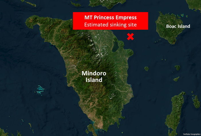
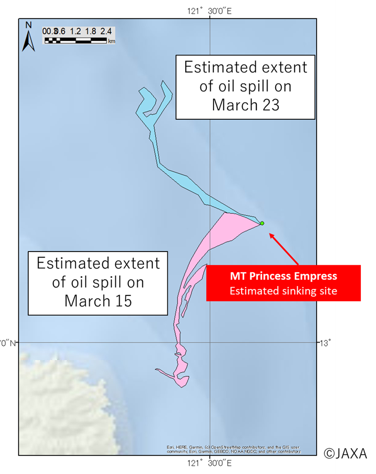
The oil spill occurred approximately 20 kilometers east off the coast of Mindoro Island. Figure 1 shows the location near the sunken tanker.
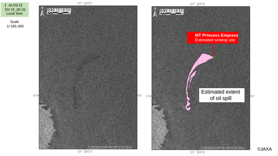
ALOS-2 conducted a total of six observations on the eastern side of Mindoro Island and other surrounding waters between the accident date and March 25 (Here after all times are local time). Of those observations, two imaging results (March 15 at 00:01 and March 23 at 23:55) are presented here.
In Figure 2 and 3, the land (island) and the tanker appear bright (white color) because of strong reflection of radio waves emitted from the radar. In contrast, ocean surface appears dark (black color) due to weak reflection. Location where oil is floating appears much darker (black). For more information on how radar images look like, please see the article in 2020 “Cooperation for the oil spill incident in Mauritius coast by using “ALOS-2” observation”
The image on March 15 (Figure 2) shows the oil spill spreading to the island (southwest) from the estimated sinking site.
The image on March 23 (Figure 3) shows oil continuing to spill from the same site, but the direction of the oil spill changed to the northwest (Figure 4).
JAXA will continue to cooperate by observing this oil spill to confirm the latest situation and providing analysis results.
Satellite images showing oil spill spreading to Mindoro Island (southwest) from the estimated sinking site of MT Princess Empress
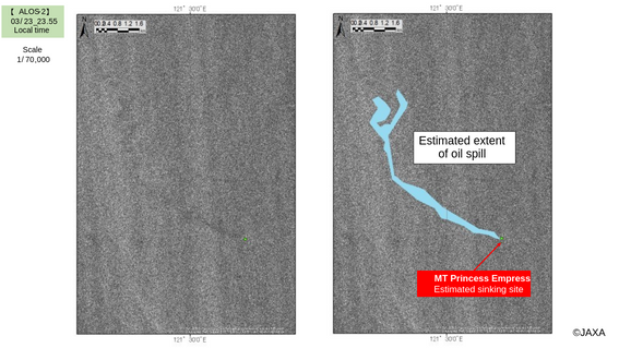
Satellite images showing oil spill spreading to the northwest from the estimated sinking site
Provision of satellite images to Sentinel Asia and International Charter
In addition to support to JDR, JAXA provided a series of images observed by ALOS-2 to two international cooperation frameworks, ”Sentinel Asia” and “International Charter Space and Major Disasters,” according to their observation requests.
In those frameworks, for this incident, products that are analysis results of optical and SAR images from various countries have been created and uploaded to each website. The products look different from each other due to the types of sensors, but they all show that oil continues to spill from the sunken position and that the direction of the oil spill changes from day to day. These results are also consistent with a change in the outflow direction from southwest to northwest, observed by ALOS-2. Those products, including ones created by the Philippine Space Agency (PhilSA), were provided to JDR and used for oil spill response activities.
“Sentinel Asia” is an international cooperation project launched with the aim of contributing to disaster management in the Asia-Pacific region leveraging space technologies. The propose is to mitigate damages, caused by natural disasters, sharing disaster information such as images from earth observation satellites on the Internet. “Sentinel Asia” has a total of 113 members, including research institutes which analyze satellite data to provide damage information and disaster management agencies which use provided data and information for disaster response, in addition to space agencies (as of March 2023). “International Charter Space and Major Disasters” is an international cooperation framework to provide images of earth observation satellites to users in the event of a large-scale disaster. Currently, 17 space agencies including JAXA are members.
- Sentinel Asia Report on Oil Spill in Philippines
https://sentinel-asia.org/EO/2023/article20230228PH.html - International Charter Space and Major Disasters Report on Oil Spill in Philippines
https://disasterscharter.org/web/guest/activations/-/article/oil-spill-in-philippines-activation-807-
Exchange of opinions with the relevant organization
JAXA exchanged opinions on satellite information utilization for oil spill in the Philippines with Guard and Rescue Department*, Marine Environment Protection and Disaster Prevention Division, Japan Coast Guard at JAXA Tokyo Office on March 30, 2023. The information on a range of oil spill analyzed from ALOS-2 data had been provided to JDR and Philippine Coast Guard through the Guard and Rescue Department.
JDR and Philippine Coast Guard expressed their appreciation for usefulness of satellite information to grasp a wide range of situations and distant locations for effective incident response.
JAXA will continue to cooperate for disaster assistance including collaboration with related organizations.
References: Cooperation in Observations Based on Past Oil Spill Observations
- “ALOS-2” observation of the oil spill in the Peruvian coast caused by tsunami linked to a Tonga volcanic eruption
https://earth.jaxa.jp/en/earthview/2022/01/28/6761/index.html - Cooperation for the oil spill incident in Mauritius coast by using “ALOS-2” observation
https://earth.jaxa.jp/en/earthview/2020/08/28/1629/index.html - Santi accident in the East China Sea in 2018 (Japanese only)
https://www.satnavi.jaxa.jp/ja/news/2018/01/25/298/index.html
Search by Year
Search by Categories


Tags
-
#Earthquake
-
#Land
-
#Satellite Data
-
#Aerosol
-
#Public Health
-
#GCOM-C
-
#Sea
-
#Atmosphere
-
#Ice
-
#Today's Earth
-
#Flood
-
#Water Cycle
-
#AW3D
-
#G-Portal
-
#EarthCARE
-
#Volcano
-
#Agriculture
-
#Himawari
-
#GHG
-
#GPM
-
#GOSAT
-
#Simulation
-
#GCOM-W
-
#Drought
-
#Fire
-
#Forest
-
#Cooperation
-
#Precipitation
-
#Typhoon
-
#DPR
-
#NEXRA
-
#ALOS
-
#GSMaP
-
#Climate Change
-
#Carbon Cycle
-
#API
-
#Humanities Sociology
-
#AMSR
-
#Land Use Land Cover
-
#Environmental issues
-
#Quick Report
-
#GOSAT-GW
Related Resources


Related Tags
Disaster Related Articles
-
 Disaster 2025.10.23 Thu ALOS-2 Observations of the Earthquakes in the Philippines
(Cebu Island and Mindanao Island) -
 Disaster 2025.04.04 Fri ALOS-2 Observation of the M7.7 Earthquake in Myanmar
 -
 Disaster 2024.09.09 Mon ALOS-2 Observation of the Oil Spill Caused by the Sinking of a Tanker in Manila Bay, Philippines
 -
 Disaster 2023.04.07 Fri ALOS-2 observation: Oil spill from sunken oil tanker off Mindoro Island, Philippines (follow-up report)
Stay Connected
