


Applications
2020.08.28 Fri
Cooperation for the oil spill incident in Mauritius coast by using “ALOS-2” observation
The cargo ship, MV Wakashio ran aground on a reef in Mauritius coast on July 26, JST and spilled its fuel oil on August 6. In response to this oil spill incident, the Japan Disaster Relief Team (JDR) expert team were dispatched and has implemented oil removal, supported on environmental field and so on. JAXA also cooperates this activity. Advanced Land Observing Satellite-2 “DAICHI-2” (ALOS-2) observed the coast of Mauritius immediately and the observation data (images) has been provided to the Japan Coast Guard (JCG), which is one of the joining institutions of the JDR and the expert team. JAXA has offered technical support as well. Observation data of “ALOS-2” was analyzed by the JCG and utilized by the JDR expert team (1st Batch). JAXA continues to provide “ALOS-2” data for (2nd Batch) currently in operation.
Observation results of ocean surface near stranded ship
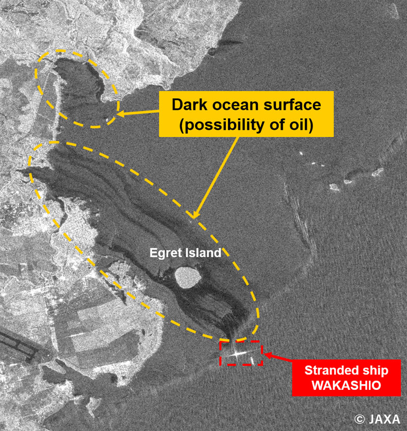
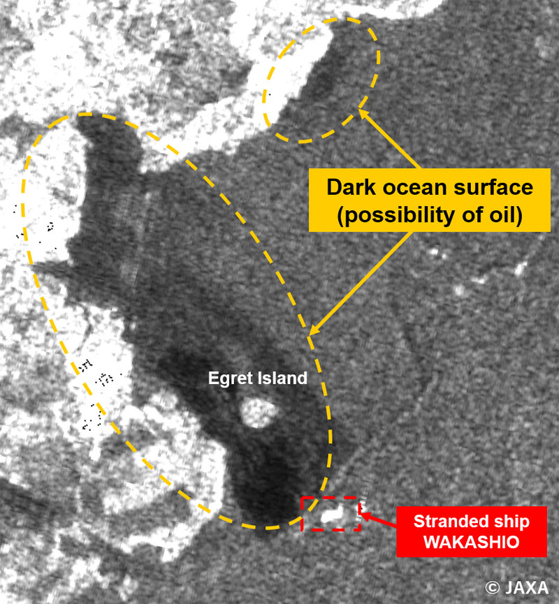
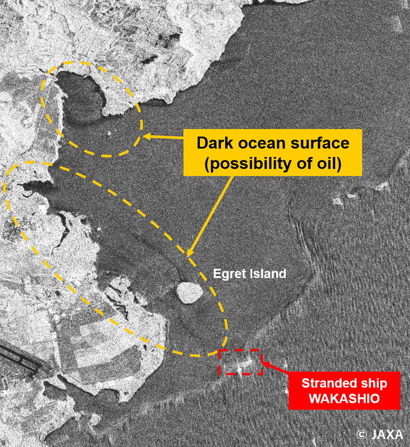
Observation for coast of Mauritius using “ALOS-2” was conducted for ten times during August 10-22, 2020. The observation results on August 10, 14, 15 and 17 (local time) will be shown down below. Lands (islands), ship, and coral lagoon with strong radio reflection toward radar are seen bright (white color) in each image. On the other hand, ocean surface looks dark (black color) due to the weakness of reflection. Location where oil is floating looks much darker (black). See the explanation of latter parts in this article. Image on August 10 shows the situation of oil spills broadening from stranded ship to the island. Compared to August 10, image of August 14 might be suggested less coverage of spilled oil. Observation image on August 15 seems to have much coverage of oil again. Image on August 17 shows less coverage of spilled oil again and the same tendency has been continued. We can see the oil spill from stranded ship has been proceeding to the Mainland Mauritius via island of Ile aux Aigrettes (Egret Island) from some observations.
According to the information of surface current based on plural satellite data, the average current in east coast of the Mainland Mauritius was from east to west since August 1st. We consider this is because of the effect of surface current.
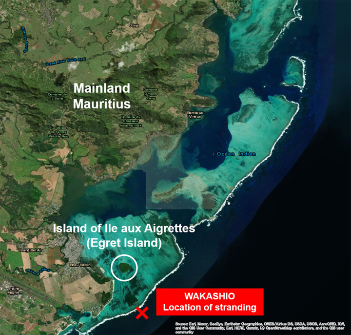
Figure 1. Location of Mauritius and stranded vessel

Surface current near Mauritius
OSCAR (Ocean Surface Current Analysis Real-time:Earth and Space Research) is analyzing plural satellite data. Its 5 days average of tidal velocity shows east coast of Mauritius (center of Figure 6.) has western direction (to the Mainland Mauritius) during August 7~11, about 0.2m/s. Same condition can be seen during August 12~16, about 0.3m/s. According to “ALOS-2” observation, situation of oil spill could be confirmed from stranded ship to the Mainland Mauritius, and this surface current is also corresponded. Note that oil flow is affected by wind and sea tide as well.
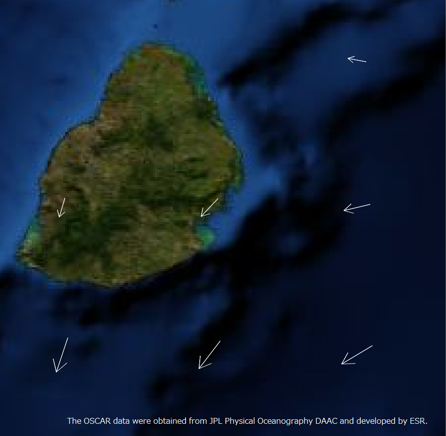

Figure 6. Surface current based on the information from satellite observation (August 7-11, 2020 (left) and August 12-16 (right) 5 days average value)
Explanation: Observation of oil in the ocean surface using radar satellite
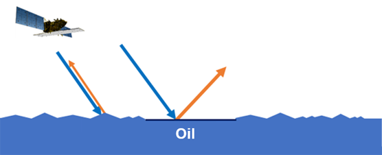
Due to differences in surface tension, water (ocean water) and oil do not mix, and oil with a low-density float on oceanwater. In addition, waves on the surface of the ocean are mainly caused by wind (ocean wind). The stronger the wind, the higher the waves (wind waves). Therefore, where there is oil on the surface of the ocean, the waves (caused by the wind) are smaller than those around the area where there is no oil. Radar satellites are used to observe oil on the ocean surface using this phenomenon.
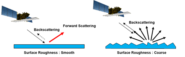
Radar satellites such as “ALOS-2” emit microwaves and measure the scattered (reflected) radio waves (backscattered). As shown in the next left figure, when the sea surface is smooth (waves are small, calm), the radiated radio waves appear darker in the image because they reflect (scatter) further forward.
On the other hand, as shown in the figure on the right, if the ocean surface is rough (high waves or angry), the waves (raised ocean surface) cause strong backscatter and appear brighter in the image. The ship is made of materials (mostly metal) that reflect radio waves easily. So, it looks brighter in the images shown here.
In summary, the area contained oil tends to have less wave and the reflection seems less weak when radar satellites observe. See the figure below.
This time, observation by optical satellites are also utilized adding to radar satellites like “ALOS-2” in order to analyze oil spills incident in Mauritius coast. Presence of clouds prevent optical satellites to observe ocean surface. On the other hand, radar satellites can observe ocean surface both day and night regardless of weather. Note that location like inside bay with not so much wave has the character to have less wave even in case of no oil. And backscattering toward the radar is sometimes weak. Also, it is difficult to distinguish existence or non-existence of oil when wind is weak (no wave even with no oil) and wind is strong (waves happen even with oil). So, there are possibilities that actual ocean surface has no oil even when observation image of “ALOS-2” here seems to have oil. JAXA is planning to examine it after catching local situation (if local information is available).
Contribution to the “International Disasters Charter”
In addressing this incident, in addition to the support for the Japan Disaster Relief Team and the expert team, JAXA provided ALOS-2 data as part of the activities of the International Charter: Space and Major Disasters or “International Disasters Charter”.
The International Disasters Charter is an international collaboration, through which satellite data are made available for the benefit of disaster management in case of huge disasters. Launched in 1999, the International Charter is currently composed of 17 member organizations including JAXA. Since JAXA became a member, JAXA has provided its “ALOS” and “ALOS-2” data many times in response to requests made to the International Disaster Charter in case of huge disasters.
“ALOS-2” data acquired to monitor the oil spill in Mauritius were provided to the International Disaster Charter and made available for analyses of estimated damages to many institutions such as United Nations Institute for Training and Research (UNITAR) .
International Disasters Charter’s dedicated webpage for oil spill in Mauritius coast:
https://disasterscharter.org/web/guest/activations/-/article/oil-spill-in-mauritius-activation-666-
About ALOS-2 (Daichi-2)
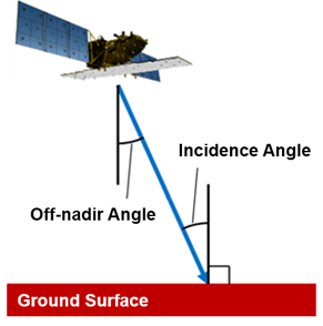
This time, high resolution mode (resolution 3~10 m) and widespread mode were used. Polarization mode observed using HH and HV and analyzed HH image. Off-nadir angle in the observation image shows the angle calculated by the direction of vertically located below satellite and radio irradiation. It affects obtained images. Also, it is almost same as “incidence angle”, which is an angle from vertical direction to satellite direction on the recorded location. Indeed, incidence angle becomes a little bigger because the earth is circle.
Explanation of the Images
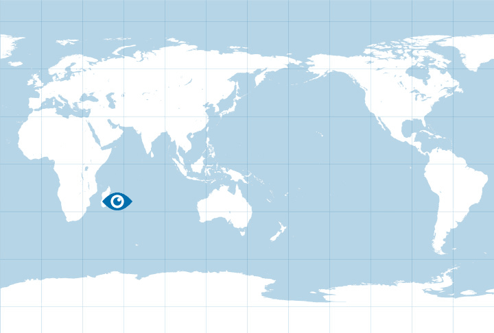
Figure 2, 3, 4, 5
| Satellite | Advanced Land Observing Satellite-2 “DAICHI-2” (ALOS-2) |
|---|---|
| Sensor | Phased Array type L-band Synthetic Aperture Radar-2 (PALSAR-2) |
| Date |
August 10, 2020 11:36 (local time) (Figure 2) August 14, 2020 00:37 (local time) (Figure 3) August 15, 202011:42 (local time) (Figure 4) August 17, 2020 (local time) (Figure 5) |
Related Sites
- “ALOS-2” observed oil spill area in 2018 when the oil tanker “SANCHI” incident happened in East China Sea. (in Japanese)
- About Advanced Land Observing Satellite-2 “DAICHI-2” (ALOS-2)
- International Disasters Charter’s dedicated webpage for oil spill in Mauritius coast
- Seen from Space Category : Applications
Search by Year
Search by Categories


Tags
-
#Earthquake
-
#Land
-
#Satellite Data
-
#Aerosol
-
#Public Health
-
#GCOM-C
-
#Sea
-
#Atmosphere
-
#Ice
-
#Today's Earth
-
#Flood
-
#Water Cycle
-
#AW3D
-
#G-Portal
-
#EarthCARE
-
#Volcano
-
#Agriculture
-
#Himawari
-
#GHG
-
#GPM
-
#GOSAT
-
#Simulation
-
#GCOM-W
-
#Drought
-
#Fire
-
#Forest
-
#Cooperation
-
#Precipitation
-
#Typhoon
-
#DPR
-
#NEXRA
-
#ALOS
-
#GSMaP
-
#Climate Change
-
#Carbon Cycle
-
#API
-
#Humanities Sociology
-
#AMSR
-
#Land Use Land Cover
-
#Environmental issues
-
#Quick Report
-
#GOSAT-GW
Related Resources


Related Tags
Applications Related Articles
-
 Applications 2024.01.15 Mon The Use of Earth Observation Satellite Data in the Humanities and Social Sciences (2)
 -
 Applications 2023.11.29 Wed The Use of Earth Observation Satellite Data in the Humanities and Social Sciences (1)
 -
 Applications 2023.08.04 Fri Contribution to SDGs Goal 6 “Clean Water and Sanitation”
 -
 Applications 2023.07.10 Mon Contribution to SDGs Goal 15 “Life on Land”
Stay Connected
