


Latest Observation
2011.03.28 Mon
Miyazaki and Aoshima, Japan
caption on
caption off
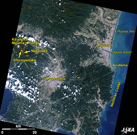
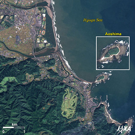
Figure 1 is an image of southern Miyazaki Prefecture, Japan, as observed by ALOS (“Daichi”) in November 2010. The city visible at the upper right is Miyazaki, the capital of Miyazaki Prefecture. Since Miyazaki faces the Pacific Ocean (the Hyuga Sea) where the Black Current flows, its climate is rather mild with rich precipitation and sunshine. The warm climate helps the forcing culture of tomatoes, green peppers, and cucumbers in the Miyazaki Plain extending south of the Oyodo River. Mt. Shinmoedake in the Kirishima Mountain Range, visible at the left of the image, has recently erupted repeatedly.
caption on
caption off
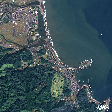
Fig. 2. Enlarged Image of Miyazaki
Miyazaki (kmz, 5.47 MB, Low Resolution) as seen on Google Earth.
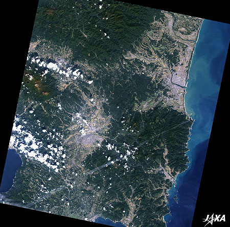
Figure 2 is an enlarged image of Miyazaki. Miyazaki, with a population of 400,000, has developed since the prefectural office was placed there in the Meiji period (1868-1912) and became the largest city in the prefecture. Miyazaki Prefecture was called Hyuga Province, where small domains such as Nobeoka, Obi, and the feudalities of Satsuma and the Shogunate were complexly located. During the Meiji Restoration, abolition of the domain system and establishment of the prefectural system took place, and Mimitsu Prefecture and Miyakonojo Prefecture were established on both sides of the Oyodo River. The two prefectures were consolidated later becoming Miyazaki Prefecture with the capital placed in the middle. Without having a historical core, the capital developed rapidly as a center of politics and commerce, and was promoted to Miyazaki City at its municipalization in 1924.
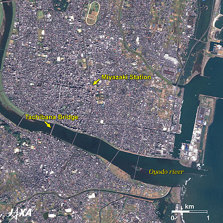
The Oyodo River, originating at Mt. Nakadake located in the caldera of Mt. Aso in Kagoshima Prefecture, runs through the Miyakonojo Basin and flows into Miyazaki. As seen in Figure 2, the urban areas extend on both sides of the river and are connected by many bridges. Since there was no bridge in the Meiji period, people had to use punts to cross the river. Local medical doctor Kuninari Fukushima built a wood bridge at his own expense in 1880, called Tachibana Bridge (the fifth bridge from the river mouth). The present reinforced concrete bridge is the sixth generation and has become a symbol of the city.
Aoshima and the Nichinan Coast
The island jutting out into the Hyuga Sea southeast of the Oyodo River is a well-known resort island called Aoshima. Smooth coast line to the south from the river draws a complex pattern. The coast from Aoshima to Cape Toi at the southernmost part of the prefecture is the Nichinan Coast.
caption on
caption off
Fig. 3. Aoshima and Its Vicinity
Aoshima and Its Vicinity (kmz, 4.52 MB, Low Resolution) as seen on Google Earth.
Figure 3 is an enlarged image of Aoshima and its vicinity. Aoshima is 1.5 kilometers around and 6 meters above the sea at its highest. It is connected by a bridge and now by a sandbar on the opposite coast. A unique rock formation around the island was created by strata, with sandstone and mudstone overlapping in turns, and rose to the surface through the erosion of crashing waves. Due to its resemblance to a washboard, the landform is referred to as “the Devil’s Washboard” and was designated a national Natural Monument as “Aoshima Upheaval from the Sea Floor and Wave-shaped Rocks.” Subtropical plant communities of Chinese fan palms (Livistona chinensis palm) and orchid trees (Bauhinia scandens) on the island are also designated national Special Natural Treasures.
The Phoenix Road along the Nichinan Coast is the first road park developed in Japan. Subtropical plants along the road, such as the phoenix tree, together with the golden sunshine and the blue ocean, give this area a southern atmosphere.
Explanation of the Images:
| Satellite: | Advanced Land Observing Satellite (ALOS) (Daichi) |
| Sensor: |
Advanced Visible and Near Infrared Radiometer-2 (AVNIR-2) Panchromatic Remote-sensing Instrument for Stereo Mapping (PRISM) |
| Date: | 0104 (UTC) on November 11, 2010 (Simultaneous Observation of AVNIR-2 and PRISM) |
| Ground resolution: | 10 m (AVNIR-2) and 2.5 m (PRISM) |
| Map Projection: | Universal Transversal Mercator (UTM) |
AVNIR-2 has four observation bands. The color composite images are produced by assigning red to Band 3 (610 to 690 nm), green to Band 2 (520 to 600 nm), and blue to Band 1 (420 to 500 nm). The resulting images have natural coloring as if seen by the naked eye. Each color indicates the following ground objects:
| Deep green: | Forests |
| Light green: | Grass fields or lawn |
| Brown: | Farmlands or bare land |
| Blue: | Water surface |
| White: | Roads, buildings, or clouds |
(Fig. 2 and 3)
PRISM is an optical sensor for observing ground surfaces with visible and near-infrared signals in the 520- to 770-nanometer (one-billionth of a meter) band. The image is monochromatic but has a higher resolution. PRISM has three independent optical systems to acquire images in the view of nadir, forward, and backward simultaneously. Only the nadir images are used in the images.
The above AVNIR-2 color composite image is decomposed into hue, saturation, and intensity. The intensity portion is replaced by PRISM data. The hue, saturation, and intensity data are then reversed into a color image. This color image has a virtual 2.5-m resolution. A color image composed by combining a higher resolution monochromatic image and a lower resolution color image is called a pan-sharpened image.
Related Sites
Nagasaki and Warship Island The Seaport Town opened to the World in the Edo Era and the Island that supported Industrialization in Japan
Le Mont-Saint-Michel
Search by Year
Search by Categories


Tags
-
#Earthquake
-
#Land
-
#Satellite Data
-
#Aerosol
-
#Public Health
-
#GCOM-C
-
#Sea
-
#Atmosphere
-
#Ice
-
#Today's Earth
-
#Flood
-
#Water Cycle
-
#AW3D
-
#G-Portal
-
#EarthCARE
-
#Volcano
-
#Agriculture
-
#Himawari
-
#GHG
-
#GPM
-
#GOSAT
-
#Simulation
-
#GCOM-W
-
#Drought
-
#Fire
-
#Forest
-
#Cooperation
-
#Precipitation
-
#Typhoon
-
#DPR
-
#NEXRA
-
#ALOS
-
#GSMaP
-
#Climate Change
-
#Carbon Cycle
-
#API
-
#Humanities Sociology
-
#AMSR
-
#Land Use Land Cover
-
#Environmental issues
-
#Quick Report
-
#GOSAT-GW
Related Resources


Related Tags
Latest Observation Related Articles
-
 Latest Observation 2026.06.05 Fri [Quick Report] Typhoon No. 6, “JANGMI”, brought heavy rain to Japan. – Results of satellite data analysis –
 -
 Latest Observation 2026.04.16 Thu [Quick Report] EarthCARE Captured the Eye of Typhoon Sinlaku
 -
 Latest Observation 2025.12.03 Wed [Quick Report] Analysis results from satellite precipitation data on the record-breaking heavy rainfall occurring in Southeast Asia in late November 2025
 -
 Latest Observation 2025.10.01 Wed [Quick Report] Hurricane Humberto “Eye” captured by EarthCARE satellite (Hakuryu)
Stay Connected
