


Latest Observation
2011.01.12 Wed
Sakurajima and Kagoshima, Japan
caption on
caption off
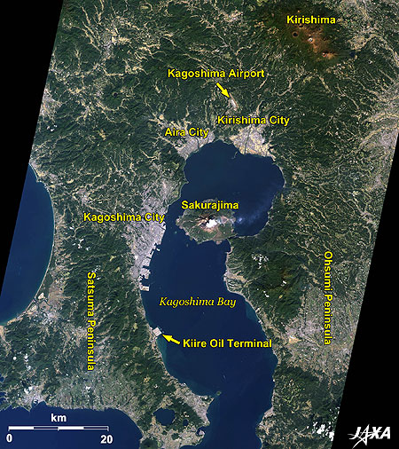
Figure 1 is an image of Sakurajima and its surroundings taken by ALOS (“Daichi”) in November 2008. Kagoshima Bay, otherwise known as Kinkou Bay, is seen in the middle of the image and the island in the bay is Sakurajima. The east side of the island is connected to the Ohsumi Peninsula and the opposite side of the bay is the Satsuma Peninsula. The cities of Kagoshima, Aira, and Kirishima are seen along the coast of the bay. Sakurajima is part of Kagoshima City.
Kagoshima Airport, about 30 km north of Kagoshima City, and the Kiire Oil Terminal, about 20 km south of the city, are visible in the image. The Kiire Oil Terminal was constructed on a square piece of reclaimed land. It stores about 7.35 million kiloliters of oil, which is almost equivalent to what Japan consumes in 2 weeks.
The Kirishima Mountains at the upper-right of the image have twenty-three volcanoes and six crater lakes. Kirishima is famous for its hot springs and Japanese mythology of the descent of the gods.
caption on
caption off
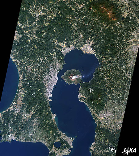
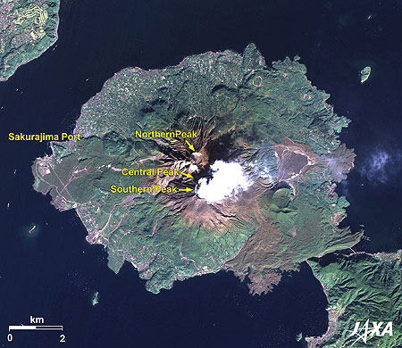
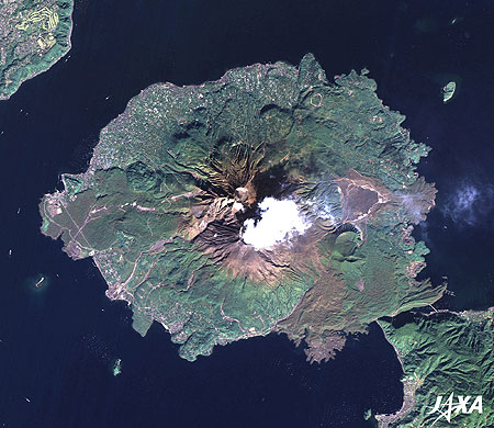
Figure 2 is a full view of Sakurajima, which became connected to the Ohsumi Peninsula during the 1914 eruption. Access to Sakurajima is available from the Ohsumi Peninsula via road or from Kagoshima City via ferry.
Sakurajima has a complex volcanic origin comprising the Northern Peak (1,117 m), Central Peak (1,060 m), and Southern Peak (1,040 m) with an area of 80 square kilometers. The brownish summit area of the mountain is covered by lava and volcanic ash. There are also some huge round craters. White volcanic smoke is seen in the image. The Southern Peak has erupted quite often in recent years. The Japan Meteorological Agency has designated the volcano A-class, of the highest activity, and has been conducting fixed-point observations of the volcano. The volcano erupted 548 times in 2009, and in October 2010, it broke that record. The JMA raised the alert level from 2 to 3 (meaning it is a no-go area).
Since volcanic ash has a huge influence on public life, the Kagoshima Prefectural Office is continuously observing the ash.
caption on
caption off
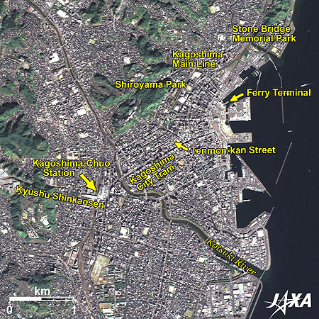
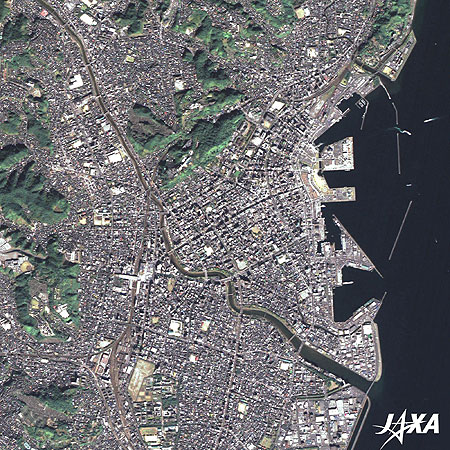
Fig. 3. Enlarged Image of Central Kagoshima City
Central Kagoshima (kmz, 5.54 MB, Low Resolution) as seen on Google Earth
Figure 3 is an enlarged image of central Kagoshima City. The Kotsuki River flows through the middle of the city. Five large arch-shaped stone bridges once crossed the river. These bridges were familiar to the locals, but two of the bridges were washed out by torrential rainfall in 1993. The remaining three stone bridges were moved to Memorial Park, seen at the upper-right of the image, in an effort to pass the history of the five bridges and technologies used to build them to future generations.
A building shaped like an L on its back is visible in the middle of the image. This building is Kagoshima-Chuo Station, formerly called West Kagoshima Station. The name was changed when the Kyushu Shinkansen (bullet train) started operation. The Kagoshima Main Line runs north and south, while the Shinkansen travels west under the mountain.
The green area along the Kagoshima Main Line to the north crossing over the Kotsuki River is Shiroyama (Castle Mountain) Park. Saigo Takamori, one of the founders of the Meiji Government, committed seppuku in the cave of the park at the end of the Seinan War (Southwestern War or Satsuma Rebellion) in 1877.
Streetcar service is operated on the main street running from Kagoshima-Chuo Station to the northeast. The downtown area, called Tenmon-kan, is located along this street. The ferry terminal to Sakurajima is seen at the end of the street.
Kyushu Shinkansen
The Kyushu Shinkansen is now in service between Kagoshima-Chuo Station and Shin-Yatsushiro Station in Kumamoto. The traditional express train connects Shin-Yatsushiro Station and Hakata Station in Fukuoka in about 2 hours and 10 minutes. The Shinkansen service between Shin-Yatsushiro and Hakata is scheduled to start in March 2011. It will take about 1 hour and 20 minutes to travel between Kagoshima-Chuo Station and Hakata Station.
Tenmon-kan
The name Tenmon-kan came originally from the name Meiji-kan, an observatory that was set up by the feudal lord, Shimazu Shigehide (feudal lord of the Satsuma feudal domain) in 1779. The Satsuma feudal domain (almost the same area as present Kagoshima Prefecture) adopted its original calendar after the Tokugawa Shogunate standardized the calendar. Shigehide set up Meiji-kan to devise a precise calendar for the domain. A monument to Tenmon-kan was constructed at the shopping arcade along Tenmon-kan Street.
Reference Sites:
Explanation of the Images:
| Satellite: | Advanced Land Observing Satellite (ALOS) (Daichi) |
| Sensor: |
Advanced Visible and Near Infrared Radiometer-2 (AVNIR-2) Panchromatic Remote-sensing Instrument for Stereo Mapping (PRISM) |
| Date: | 02:06 (UTC) on November 13, 2008 (Simultaneous observation of AVNIR-2 and PRISM) |
| Ground resolution: | 10 m (AVNIR-2) and 2.5 m (PRISM) |
| Map Projection: | Universal Transversal Mercator (UTM) |
AVNIR-2 has four observation bands. The color composite images are produced by assigning red to Band 3 (610 to 690 nm), green to Band 2 (520 to 600 nm), and blue to Band 1 (420 to 500 nm). The resulting images have natural coloring as if seen by the naked eye. Each color indicates the following ground objects:
| Dark green: | Forests |
| Bright green: | Grass fields |
| Bluish-grey: | Urban areas |
| Brown: | Bare land |
| Blue: | Sea surface |
| White: | Buildings, artificial structure, or volcanic fumes |
(Fig. 2 and 3)
PRISM is an optical sensor for observing ground surfaces with visible and near-infrared signals in the 520- to 770-nanometer (one-billionth of a meter) band. The image is monochromatic but has a higher resolution. PRISM has three independent optical systems to acquire images in the view of nadir, forward, and backward simultaneously. The nadir image is used in the figure.
The above AVNIR-2 color composite image is decomposed into, hue, saturation, and intensity. The intensity portion is replaced by PRISM data. The hue, saturation, and intensity data are then reversed into a color image. This color image has a virtual 2.5-m resolution. A color image composed by combining a higher resolution monochromatic image and a lower resolution color image is called a pan-sharpened image.
Related Sites
Mt. Pinatubo, the Philippines: 15 years after the eruption
Three-Dimensional View of Mt. St. Helens, Washington
Search by Year
Search by Categories


Tags
-
#Earthquake
-
#Land
-
#Satellite Data
-
#Aerosol
-
#Public Health
-
#GCOM-C
-
#Sea
-
#Atmosphere
-
#Ice
-
#Today's Earth
-
#Flood
-
#Water Cycle
-
#AW3D
-
#G-Portal
-
#EarthCARE
-
#Volcano
-
#Agriculture
-
#Himawari
-
#GHG
-
#GPM
-
#GOSAT
-
#Simulation
-
#GCOM-W
-
#Drought
-
#Fire
-
#Forest
-
#Cooperation
-
#Precipitation
-
#Typhoon
-
#DPR
-
#NEXRA
-
#ALOS
-
#GSMaP
-
#Climate Change
-
#Carbon Cycle
-
#API
-
#Humanities Sociology
-
#AMSR
-
#Land Use Land Cover
-
#Environmental issues
-
#Quick Report
-
#GOSAT-GW
Related Resources


Latest Observation Related Articles
-
 Latest Observation 2026.06.05 Fri [Quick Report] Typhoon No. 6, “JANGMI”, brought heavy rain to Japan. – Results of satellite data analysis –
 -
 Latest Observation 2026.04.16 Thu [Quick Report] EarthCARE Captured the Eye of Typhoon Sinlaku
 -
 Latest Observation 2025.12.03 Wed [Quick Report] Analysis results from satellite precipitation data on the record-breaking heavy rainfall occurring in Southeast Asia in late November 2025
 -
 Latest Observation 2025.10.01 Wed [Quick Report] Hurricane Humberto “Eye” captured by EarthCARE satellite (Hakuryu)
Stay Connected
