


Latest Observation
2009.12.09 Wed
Tokyo’s Two Towers
caption on
caption off
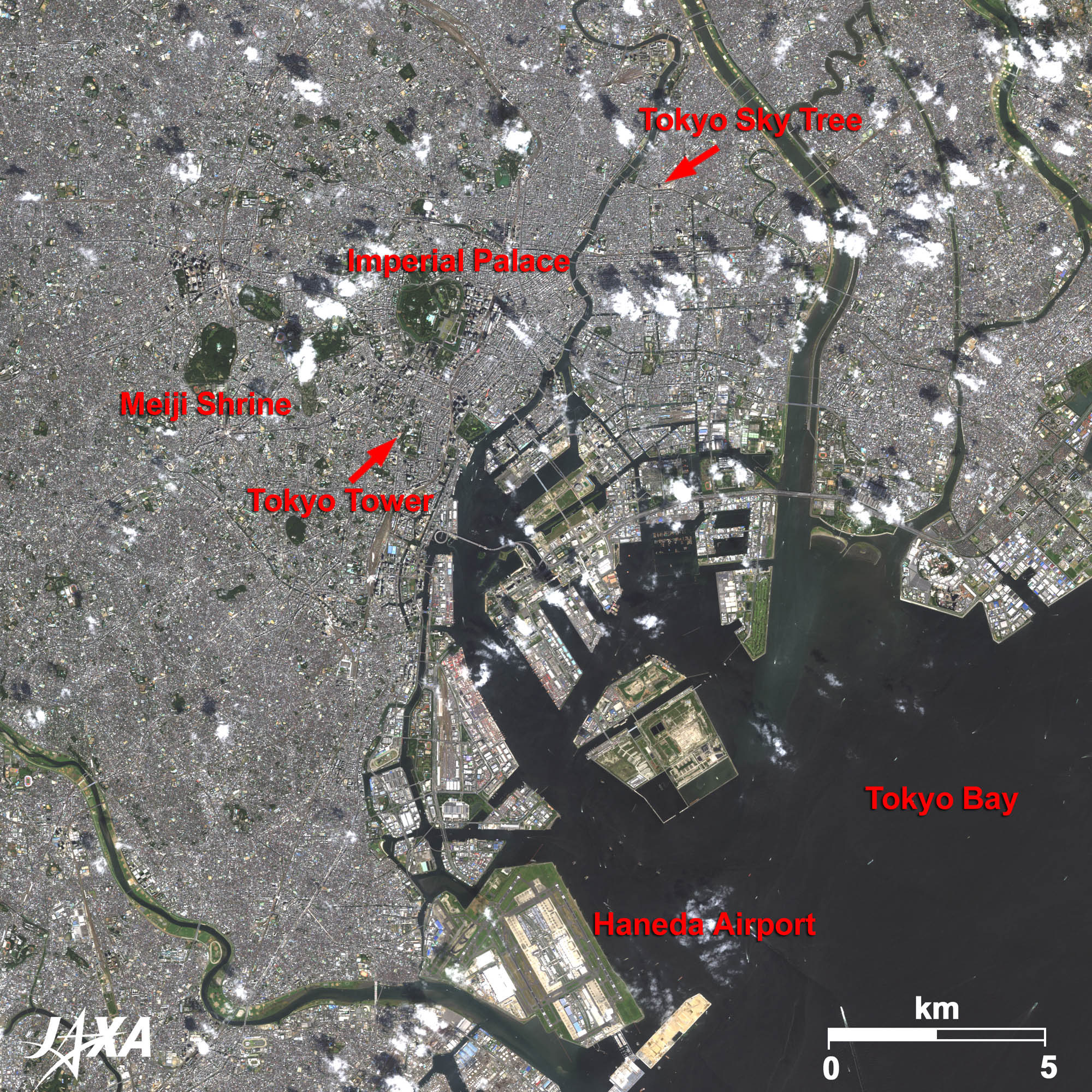
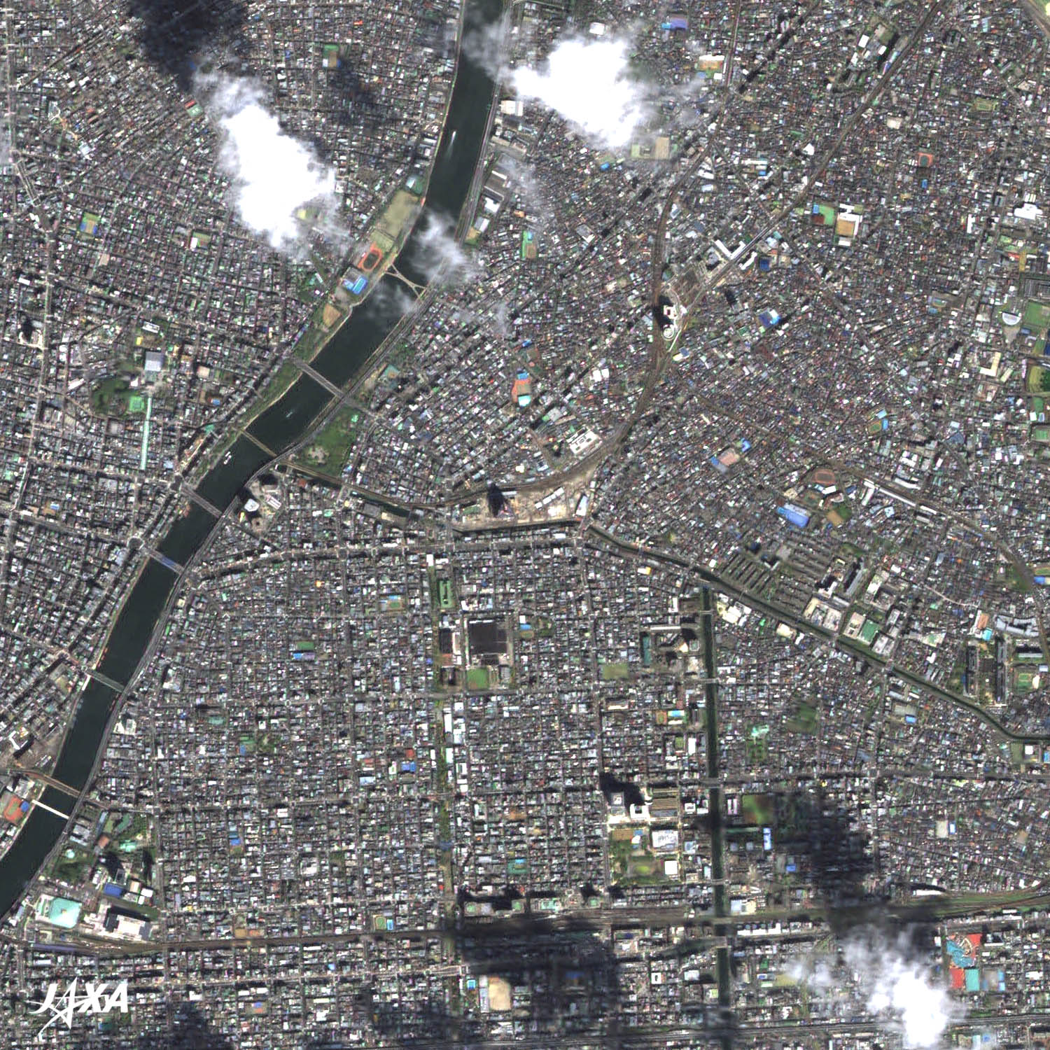
Figure 1 shows the central part of Tokyo as observed by ALOS (Daichi) in September 2009. The dark green areas visible in the figure, such as the Imperial Palace and the Meiji Shrine, are covered by forest. The scattered white blocks in the north are clouds and their shadows are projected on the ground. Haneda Airport is visible in the lower part of the image. An article on Haneda Airport was in the November 11 issue of “Seen from Space.” A new runway under construction is also visible at the bottom center.
Tokyo Tower can be seen in the middle of the image. Standing 333 meters high, Tokyo Tower began its operational service in December 1958. The tower transmits radio waves for 100 kilometers around the Kanto Plain. Terrestrial digital broadcasting started in December 2003 in the Kanto area but due to interference from some high-rise buildings taller than 200 meters in the middle of the city, construction of a new tower became necessary. A new tower, Tokyo Sky Tree, is now under construction about 5 kilometers northeast of the Imperial Palace.
caption on
caption off
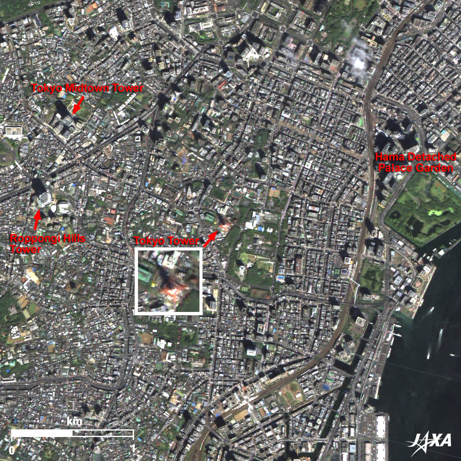
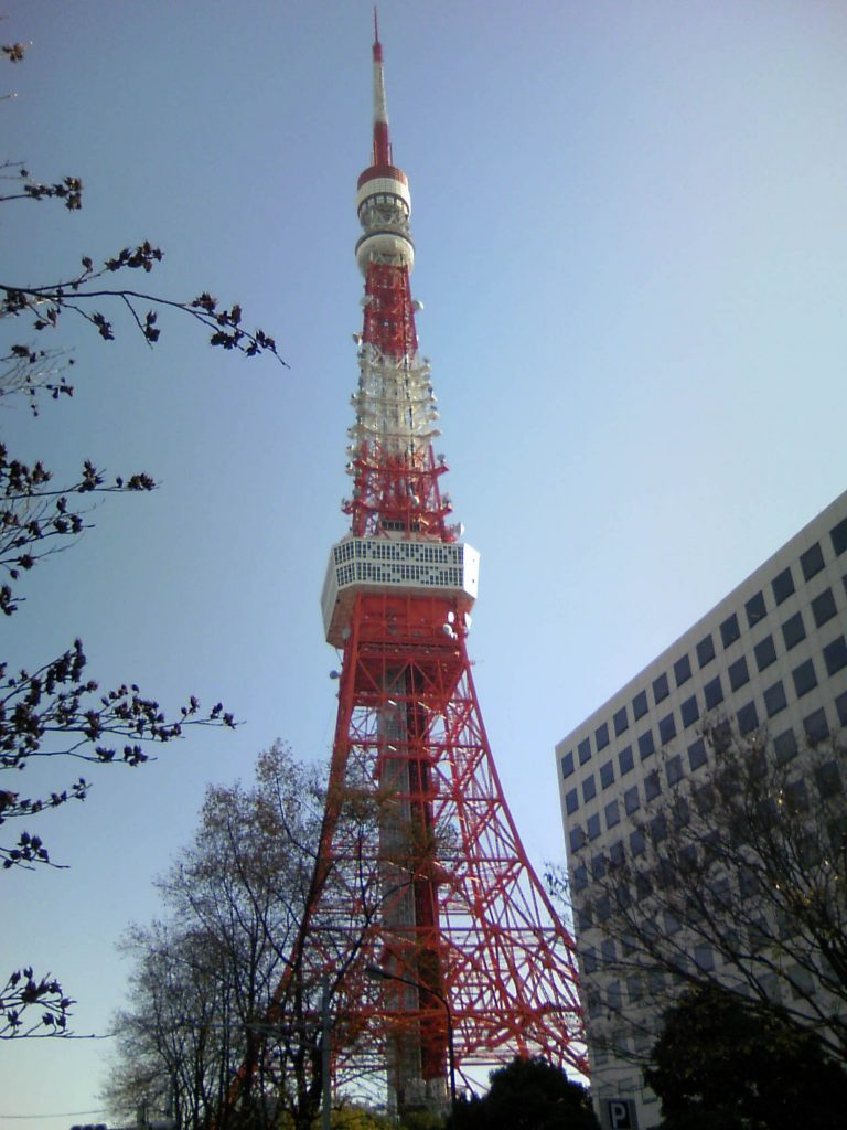
Fig. 2. Tokyo Tower and Its Surroundings
Tokyo Tower(kmz, 4.77 MB, Low Resolution) as seen on Google Earth
Figure 2 shows Tokyo Tower and its surroundings. Tokyo Tower, bordered in white at the top, is visible in the middle of the image. It is difficult to recognize the height of the Tower from space, but the long shadow cast on the ground to the northwest helps make it discernible. The shadow extends to the northwest because ALOS passes over Tokyo around 10 a.m. local time. High-rise buildings, such as Roppongi Hills and Tokyo Midtown in the upper-left of the image also throw long shadows.
The green area at the right side of the image is the Hama Detached Palace Garden. The Garden was landscaped by the Tokugawa Shogunate and remains a typical circuit style garden from the Edo era.
caption on
caption off
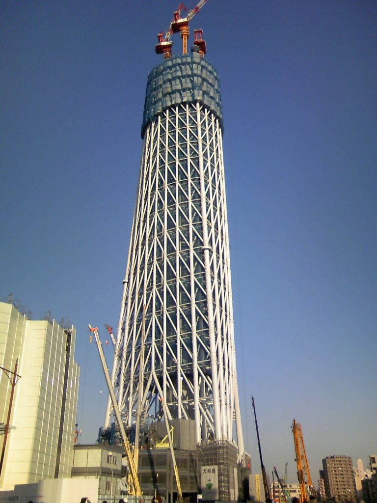
Tokyo Sky Tree (kmz, 4.91 MB, Low Resolution) as seen on Google Earth
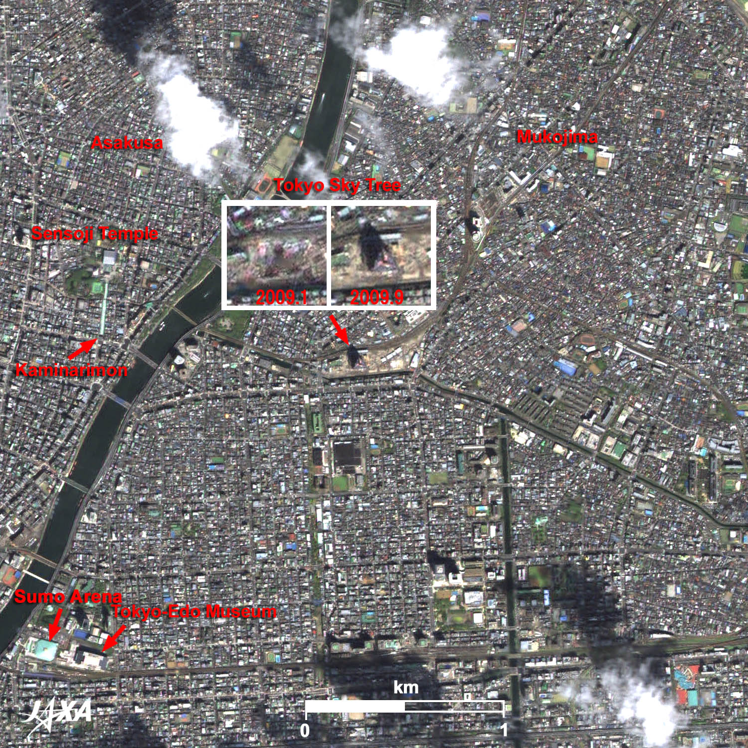
Figure 3 shows Tokyo Sky Tree and its surroundings. When completed, Tokyo Sky Tree will reach 634 meters high, and will become the highest self-supported radio tower in the world. It was already over 100 meters in August 2009, and over 200 meters by November 2009. You can see the tower at over 100 meters high and its shadow in the right enlarged image taken in September 2009; however, the tower is not visible in the left enlarged image taken in January 2009.
Construction of Tokyo Sky Tree is taking place in Oshiage, Sumida-ku, Tokyo. This area is surrounded by traditional downtowns, such as Asakusa and Mukojima. The area is also a crossing point of the Toubu railway, subways, and waterbuses.
Senso-ji (temple) and Nakamise-dori (a front approach to the temple) are visible at the left side of the image. Kaminari-mon (gate) is located at its entrance. You can also see the Sumo Arena where Sumo tournaments are held three times a year, and the Tokyo-Edo Museum, which is in the motif of an old elevated-floor-style depot and displays the culture of the Edo era and developing process of Tokyo.
Tokyo Tower
The height of Tokyo Tower (333 meters) was decided by considering the broadcasting coverage for 100 kilometers around the Kanto (Tokyo) area and safety against winds and earthquakes. The tower was the highest self-supported tower at its completion and used 4,200 tons of steel, including steel from scrapped U.S. army tanks used in the Korean War. The Eiffel Tower, at 324 meters, used about 7,000 tons of steel.
The tower is equipped with an antenna belonging to the East Japan Railway Company. This antenna broadcasts the emergency stop signal to trains of the metropolitan area. The tower is also equipped with sensors, such as an anemoscope, a thermometer, and sulfur oxides sensors in order of altitude. Therefore, the tower has been used not only as a radio wave tower but also as an environmental monitoring tower.
Tokyo Sky Tree
Terrestrial digital broadcasting waves will be transmitted from Tokyo Sky Tree, which will be twice as high as Tokyo Tower. This will reduce the interference from high-rise buildings and expand the broadcasting area of One-Seg (one segment of digital broadcasting for cellular phones). The tower will also be used as a broadcasting tool in cases of emergency.
The traditional structure of a five-storied pagoda was referred to when the tower was designed to reach over 600 meters high. Five-storied pagodas in Japan have withstood the destructive force of earthquakes and the secrecy of the pagoda’s toughness lies in the central pillar. The design of the Tokyo Sky Tree is a mixture of advanced technology and traditional structure.
Images of ALOS (Daichi) are used on the “goo maps” web page (NTT Resonant Group). You see satellite images when you click on the “aerial” button at the upper-left of the map. The background image then changes to a satellite image.
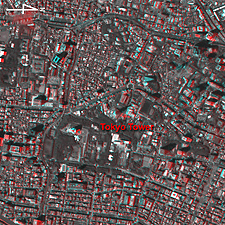
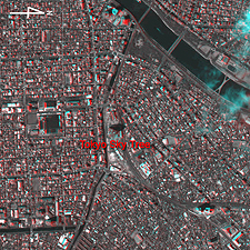
Fig. 4. Anaglyph of the Two Towers in Tokyo
(Staring at the image for a long time may cause eyestrain. Colored prints are available in PDF (Tokyo Tower, Tokyo Sky Tree). PDF files for the left (Tokyo Tower, Tokyo Sky Tree) and right (Tokyo Tower, Tokyo Sky Tree) eyes are also available.)
When viewing Figure 4 with red and blue glasses, you can see an anaglyphic image of each tower.
Reference Sites:
How to make the red and blue colored glasses (See Appendix of Three-Dimensional View of Mt. Haruna)
Explanation of the Images:
(Click the imaged twice to enlarge)
| Satellite: | Advanced Land Observing Satellite (ALOS) (Daichi) |
| Sensor: |
Advanced Visible and Near Infrared Radiometer-2 (AVNIR-2) and Panchromatic Remote-Sensing Instrument for Stereo Mapping (PRISM) |
| Date: | 01:36 (UTC) on September 6, 2009 (AVNIR-2, PRISM) |
| Ground resolution: | 10 m (AVNIR-2) and 2.5 m (PRISM) |
| Map Projection: | Universal Transversal Mercator (UTM) |
AVNIR-2 has four observation bands. The color composite images are usually produced by assigning red to Band 3 (610 to 690 nm), green to Band 2 (520 to 600 nm) and blue to Band 1 (420 to 500 nm). The resulting images have natural coloring as if seen by the naked eye. Each color indicates the following ground objects:
| Dark Green: | Forests |
| Bright Green: | Grass fields |
| Dark Grey: | Urban areas |
| Dark Blue: | Water surfaces |
| Brown: | Bare ground |
| White: | Clouds or buildings |
PRISM is an optical sensor for observing ground surfaces with visible and near-infrared signals in the 520- to 770-nanometer (one-billionth of a meter) band. The image is monochromatic but has a higher resolution. PRISM has three independent optical systems to acquire images in the view of nadir, forward, and backward simultaneously. Only the nadir images are used in these figures.
The above AVNIR-2 color composite image is decomposed into, hue, saturation, and intensity. The intensity portion is replaced by PRISM data. The hue, saturation, and intensity data are then reversed into a color image. This color image has a virtual 2.5-m resolution. A color image composed by combining a higher resolution monochromatic image and a lower resolution color image is called a pan-sharpened image.
Related Sites
Central Tokyo Dotted with Green Areas and Skyscraper-Clusters
Search by Year
Search by Categories


Tags
-
#Earthquake
-
#Land
-
#Satellite Data
-
#Aerosol
-
#Public Health
-
#GCOM-C
-
#Sea
-
#Atmosphere
-
#Ice
-
#Today's Earth
-
#Flood
-
#Water Cycle
-
#AW3D
-
#G-Portal
-
#EarthCARE
-
#Volcano
-
#Agriculture
-
#Himawari
-
#GHG
-
#GPM
-
#GOSAT
-
#Simulation
-
#GCOM-W
-
#Drought
-
#Fire
-
#Forest
-
#Cooperation
-
#Precipitation
-
#Typhoon
-
#DPR
-
#NEXRA
-
#ALOS
-
#GSMaP
-
#Climate Change
-
#Carbon Cycle
-
#API
-
#Humanities Sociology
-
#AMSR
-
#Land Use Land Cover
-
#Environmental issues
-
#Quick Report
-
#GOSAT-GW
Related Resources


Related Tags
Latest Observation Related Articles
-
 Latest Observation 2026.06.05 Fri [Quick Report] Typhoon No. 6, “JANGMI”, brought heavy rain to Japan. – Results of satellite data analysis –
 -
 Latest Observation 2026.04.16 Thu [Quick Report] EarthCARE Captured the Eye of Typhoon Sinlaku
 -
 Latest Observation 2025.12.03 Wed [Quick Report] Analysis results from satellite precipitation data on the record-breaking heavy rainfall occurring in Southeast Asia in late November 2025
 -
 Latest Observation 2025.10.01 Wed [Quick Report] Hurricane Humberto “Eye” captured by EarthCARE satellite (Hakuryu)
Stay Connected
