


Latest Observation
2009.11.11 Wed
Narita and Haneda: Two Airports in the Tokyo Metropolitan Area
There are two big airports in the Tokyo metropolitan area in Japan: Narita International Airport (initially called New Tokyo International Airport when opened in Narita, Chiba Prefecture) and Tokyo International Airport (commonly called Haneda Airport and located in Ohta-ku, Tokyo). Narita International Airport was constructed to meet the increasing demand of international flights and opened on May 20, 1978. Opening of the airport was associated with difficulty in land acquisition for runways, and expansion work is still going on after 30 years
Haneda Airport, opened on August 25, 1931, is now used as a domestic airport, but the number of carriers is a leading scale in the world. The demand of flights is skyrocketing, but flight capacity is limited; therefore, expansion work is now also underway offshore.
This article presents the two big airports from space.

caption on
caption off
Narita International Airport as seen on Google Earth (kmz format, 4.53 MB low resolution)
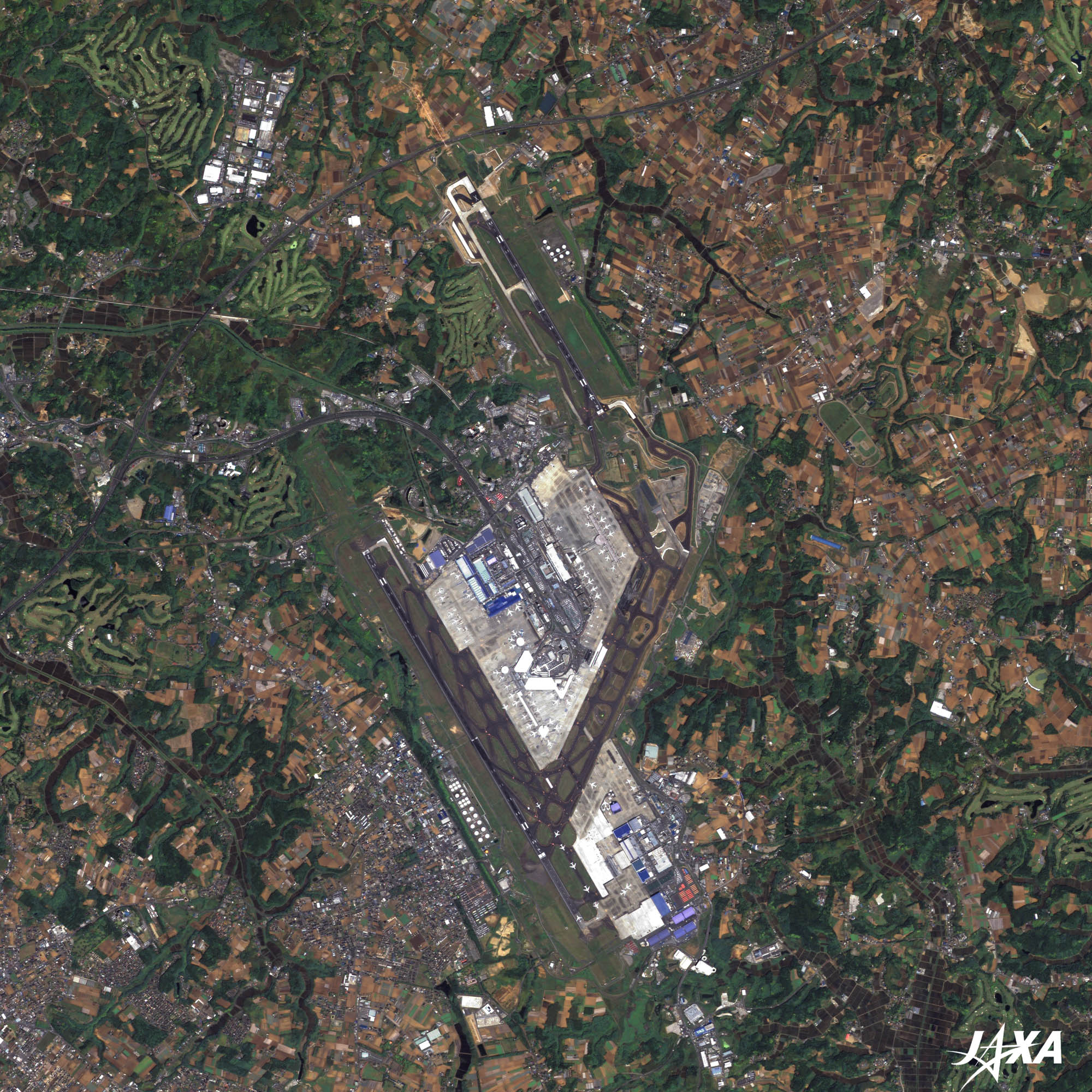
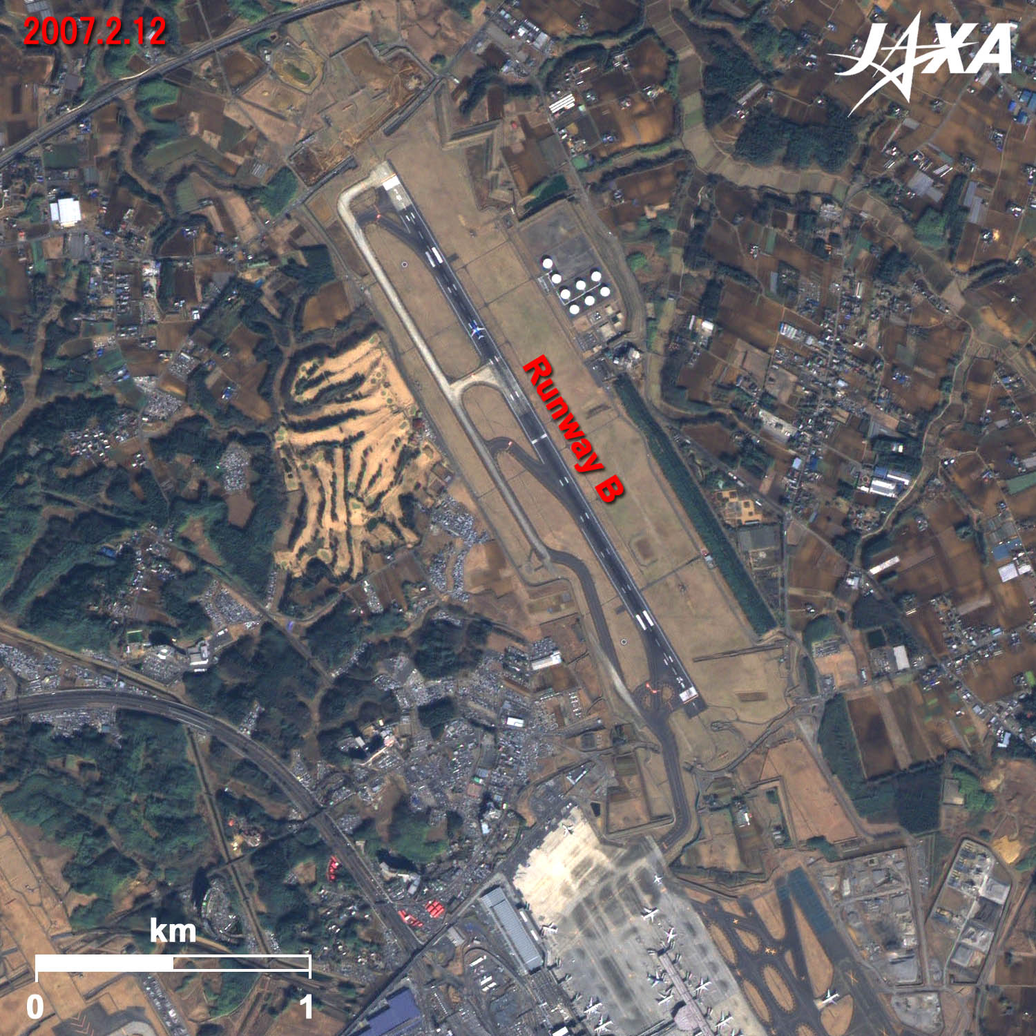
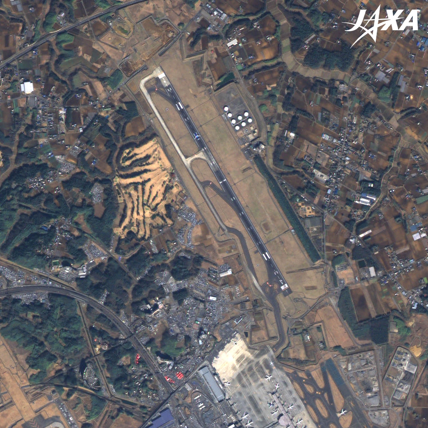
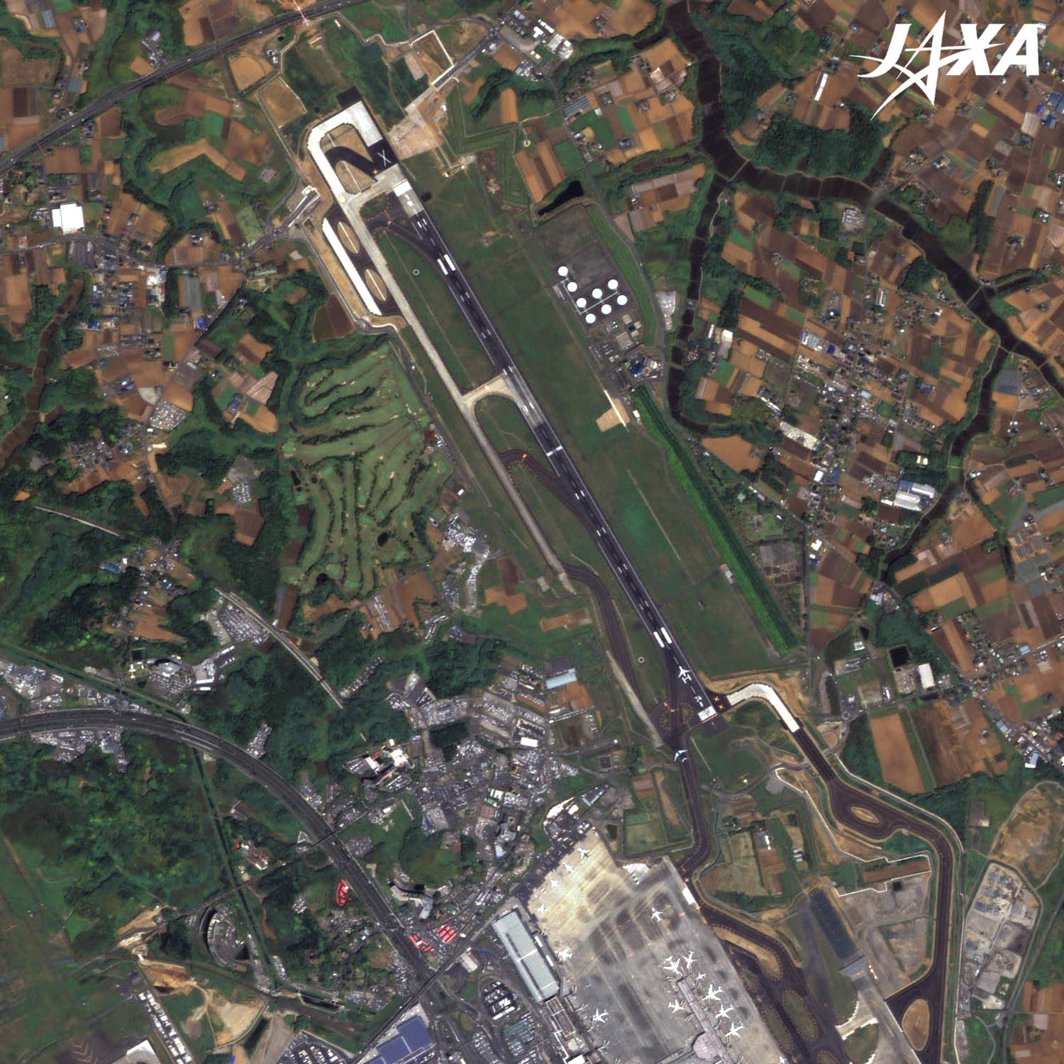
Figure 1 shows Narita International Airport and its surroundings as observed by ALOS (Daichi) in May 2009. Runway A at the west end of the airport is the longest (4,000 meters) in Japan along with the second runway at Kansai International Airport (western Japan). The 2,180-meter-long Runway B in the east is 320 meters shorter than innitially planned. Runway C, which crosses Runways A and B and planned for use when side winds blow, is 3,200 meters long. Construction of Runway C is, however, suspended and it is now used as a taxiway.
Since Narita Airport is located about 60 kilometers east of Tokyo, it is not always convenient to access. JR (Japan Railway) express trains or Keisei (a Japanese private railway) express trains, called “Skyliners”, connect Tokyo and the airport in about 50 minutes. A new high-speed railway, under construction and planned to open in July 2010, will connect the two points in 36 minutes.
caption on
caption off
caption on
caption off
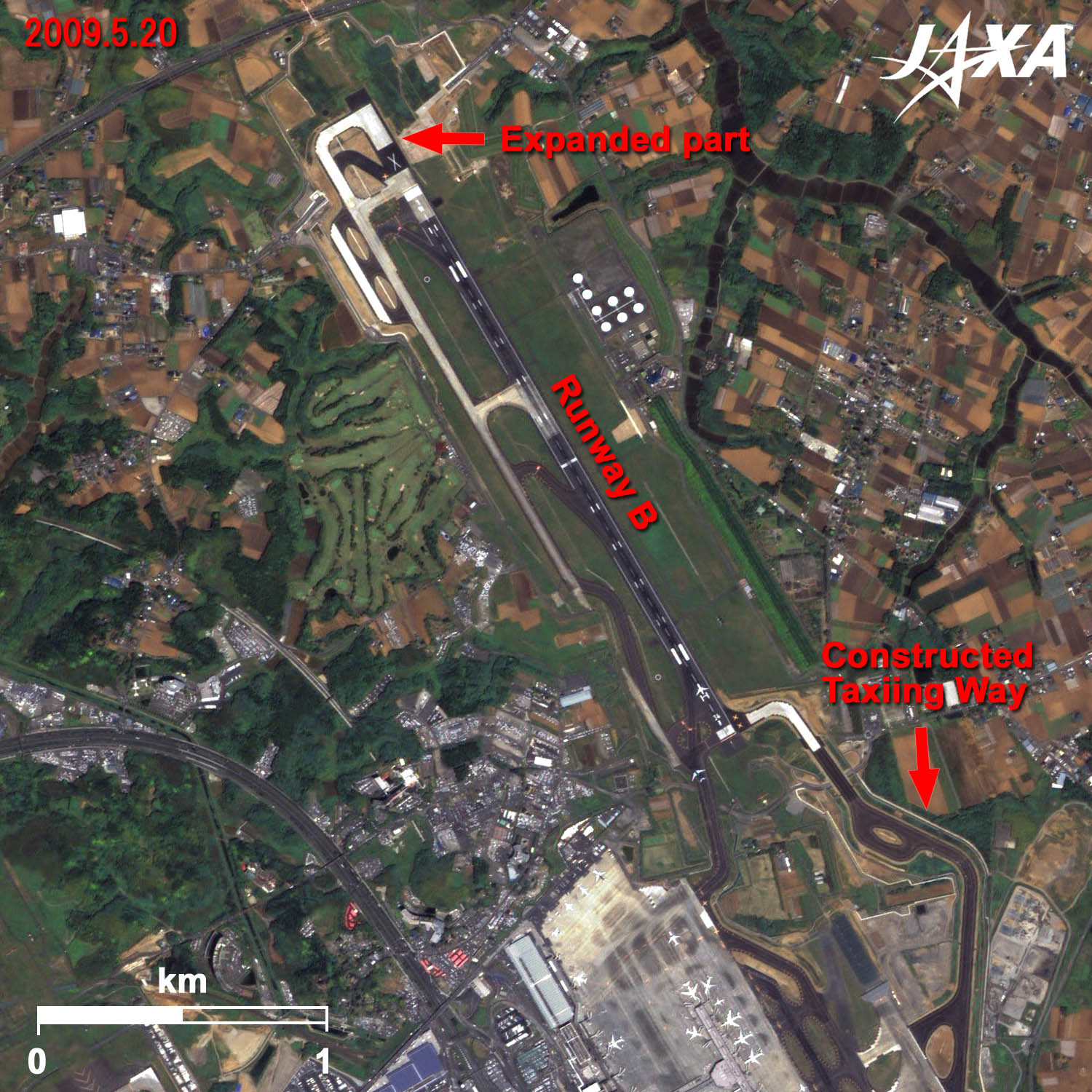
Figure 2 shows enlarged images of the north part of Narita Airport as observed in February 2007 and May 2009. These images clearly show the newly added north part of Runway B and a taxiway in the south.
The 2,500-meter-long Runway B opened its commercial service on October 22, 2009. When the runway was shorter, it was mainly used for small or middle-size carriers for Asia or Oceania. After its expansion, it will be used for larger carriers flying directly to new destinations, such as the Middle East among others. Thus, more effective flight service and improved safety are expected.

caption on
caption off
Haneda Airport as seen on Google Earth (kmz format, 3.96 MB low resolution)
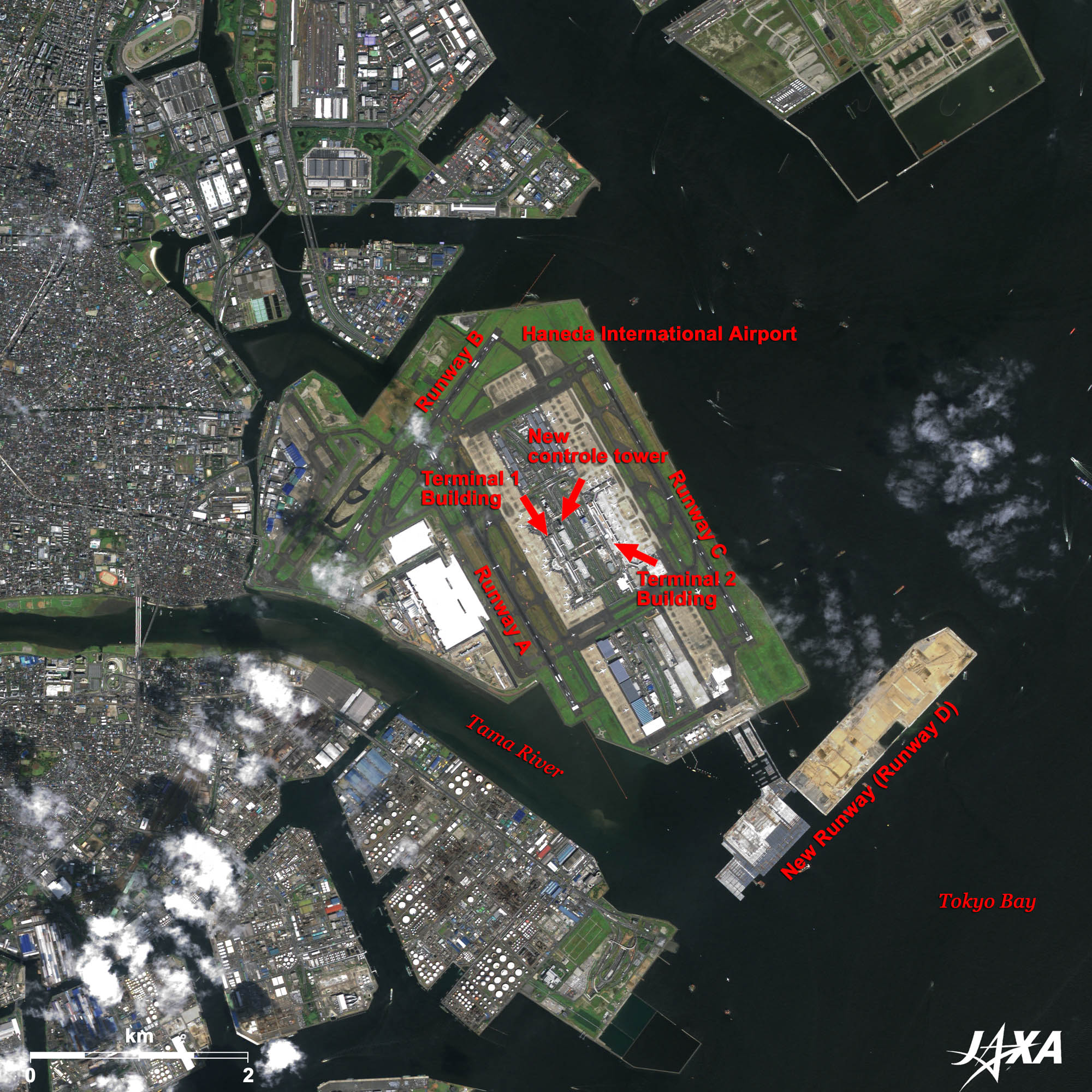
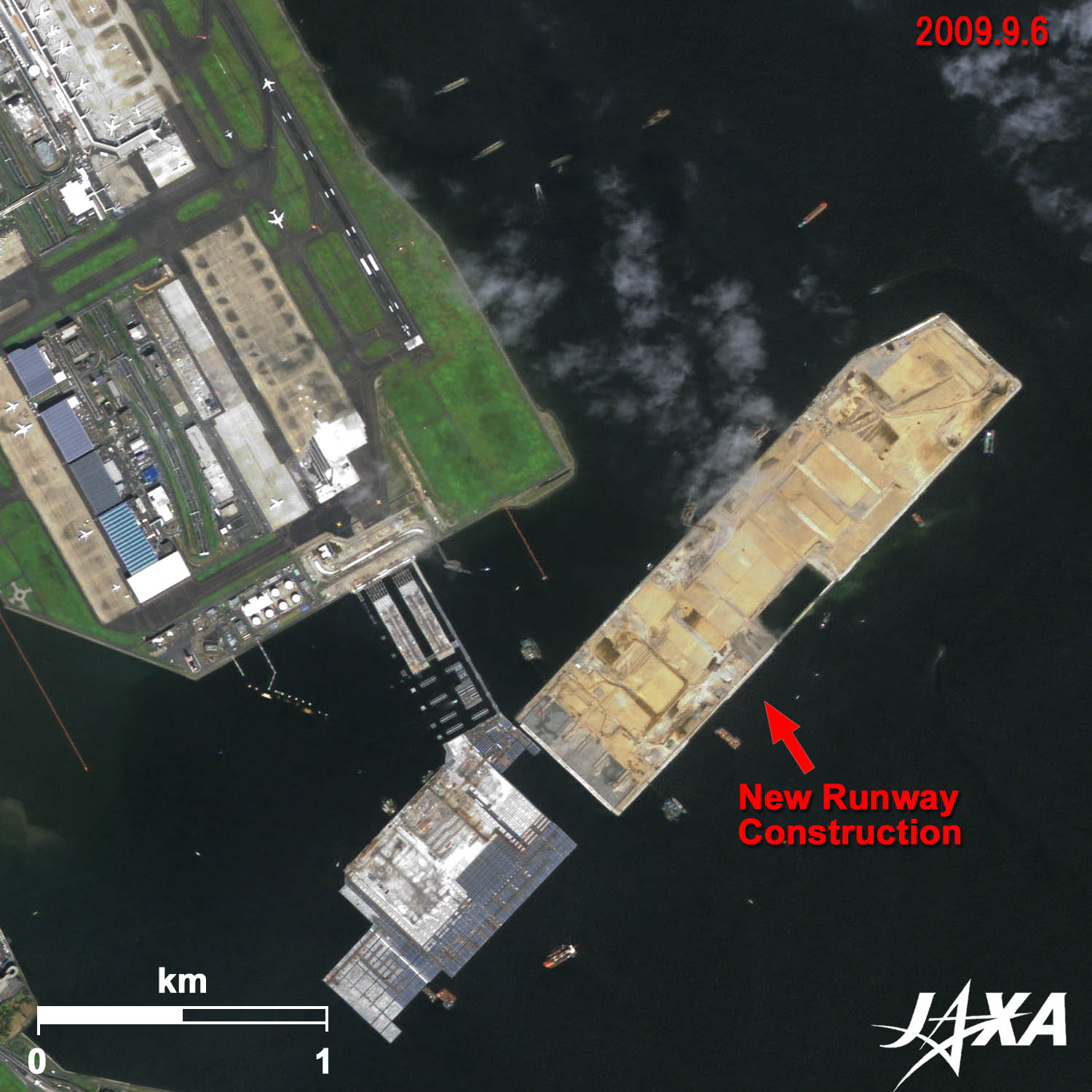
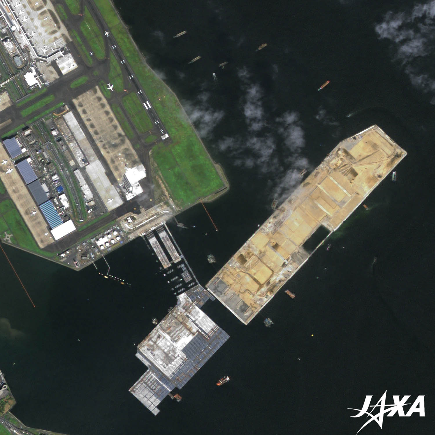
Figure 3 shows Haneda Airport as observed in September 2009. Two parallel runways, A and C, at the east and west sides of the airport are visible. They are both 3,000 meters long and can be used simultaneously. The 2,500-meter-long Runway B, seen at the north of the airport, is used when side winds blow.
The Haneda Airport expansion was started to meet increasing flight demand in January 1984. The east shore was landfilled and the airport was moved. But due to the fragile seabed, it took almost 20 years to complete. The first passenger terminal started service in September 1993, and the second passenger terminal started service in December 2004. Two terminals are visible in the middle of the image.
Because flight demand is still increasing and airport capacity has reached its limits, Runway D, near the mouth of the Tama River, is now under construction.
caption on
caption off
caption on
caption off
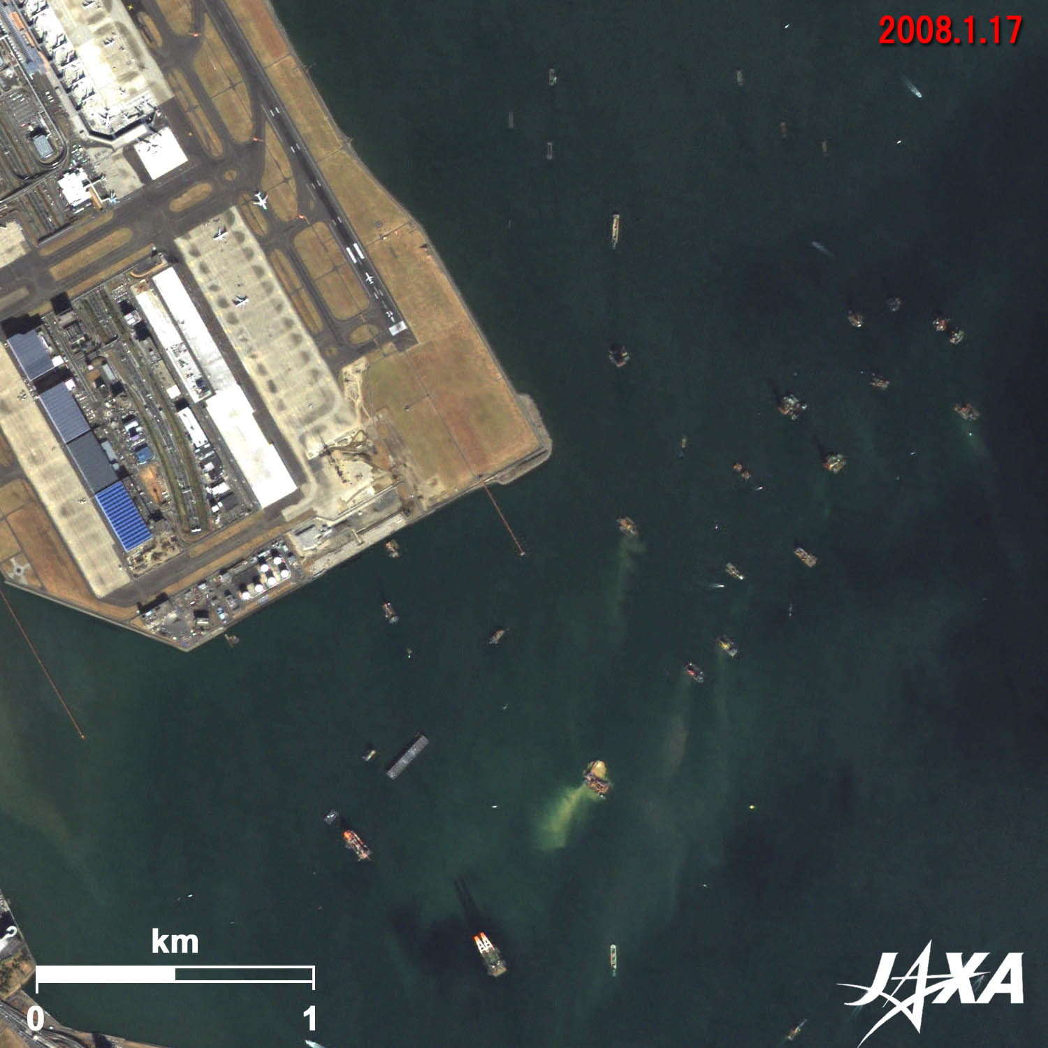
Figure 4 shows enlarged images of Haneda Airport as observed in January 2008 and in September 2009. Runway D is a 2,500-meter-long, world’s first, hybrid runway. It uses an artificial landfilled island and a pier structure, which does not prevent the flow of the Tama River. The brown area on the right is the landfilled site, and the white area on the left is the pier. The images reveal that the landfill construction has made rapid progress. This new runway was planned to be parallel to Runway B, but as Urayasu, Chiba, and the Tokyo Disney Resort are located under the flight course, the direction of the runway was changed 7.5 degrees to the right.
Figures at the End of the Runway
A figure and a letter are drawn at the end of each runway. You can see 34L and 16R at the south and the north ends of Runway A of Narita Airport in Figure 1. This figure indicates the direction of the runway. The runway is oriented at a degree ten times that of the figure clockwise from the north. Letters L and R are attached when there are parallel runways. For example, 34L of Runway A means it is a runway on the left side, pointing north-northwest, 340 degrees from the north.
At Haneda Airport, Runway C of Figure 4 has 34R in the south and 16L in the north. This means that Runway A and B of Narita Airport and Runway A and C of Haneda Airport point in the same direction.
The direction of the wind around the airport is the most important consideration. Airplanes take off or land against the wind. Therefore, runway direction is usually adjusted to the wind direction. The wind blows north-northwest in winter in the southern part of the Kanto area. Therefore, both airports have runways in the same direction.
Images of ALOS (Daichi) are used on the “goo maps” web page (NTT Resonant Group). You see satellite images when you click on the “aerial” button at the upper-left of the map. The background image then changes to a satellite image.
Explanation of the Images:
(Click the imaged twice to enlarge)
| Satellite: | Advanced Land Observing Satellite (ALOS) (Daichi) |
| Sensor: |
Advanced Visible and Near Infrared Radiometer-2 (AVNIR-2) and Panchromatic Remote-Sensing Instrument for Stereo Mapping (PRISM) |
| Date: | 01:33 (UTC) on May 20, 2009 (AVNIR-2, PRISM) (Figures1 and 2) 01:32 (UTC) on February 12, 2007 (AVNIR-2, PRISM) (Figure 2) 01:33 (UTC) on September 6, 2009 (AVNIR-2, PRISM) (Figures 3 and 4) 01:36 (UTC) on January 17, 2008 (AVNIR-2, PRISM) (Figure 4) |
| Ground resolution: | 10 m (AVNIR-2) and 2.5 m (PRISM) |
| Map Projection: | Universal Transversal Mercator (UTM) |
AVNIR-2 has four observation bands. The color composite images are usually produced by assigning red to Band 3 (610 to 690 nm), green to Band 2 (520 to 600 nm) and blue to Band 1 (420 to 500 nm). The resulting images have natural coloring as if seen by the naked eye. Each color indicates the following ground objects:
| Dark Green: | Forests |
| Bright Green: | Grass fields |
| Bright Grey: | Urban areas |
| Blue: | Water surfaces |
| White: | Roads, bare lands, or buildings |
PRISM is an optical sensor for observing ground surfaces with visible and near-infrared signals in the 520- to 770-nanometer (one-billionth of a meter) band. The image is monochromatic but has a higher resolution. PRISM has three independent optical systems to acquire images in the view of nadir, forward, and backward simultaneously. Only the nadir images are used in these figures.
The above AVNIR-2 color composite image is decomposed into, hue, saturation, and intensity. The intensity portion is replaced by PRISM data. The hue, saturation, and intensity data are then reversed into a color image. This color image has a virtual 2.5-m resolution. A color image composed by combining a higher resolution monochromatic image and a lower resolution color image is called a pan-sharpened image.
1/25,000 Scale Satellite Topographical Map, Southern Tokyo
Central Tokyo Dotted with Green Areas and Skyscraper-Clusters
Search by Year
Search by Categories


Tags
-
#Earthquake
-
#Land
-
#Satellite Data
-
#Aerosol
-
#Public Health
-
#GCOM-C
-
#Sea
-
#Atmosphere
-
#Ice
-
#Today's Earth
-
#Flood
-
#Water Cycle
-
#AW3D
-
#G-Portal
-
#EarthCARE
-
#Volcano
-
#Agriculture
-
#Himawari
-
#GHG
-
#GPM
-
#GOSAT
-
#Simulation
-
#GCOM-W
-
#Drought
-
#Fire
-
#Forest
-
#Cooperation
-
#Precipitation
-
#Typhoon
-
#DPR
-
#NEXRA
-
#ALOS
-
#GSMaP
-
#Climate Change
-
#Carbon Cycle
-
#API
-
#Humanities Sociology
-
#AMSR
-
#Land Use Land Cover
-
#Environmental issues
-
#Quick Report
-
#GOSAT-GW
Related Resources


Related Tags
Latest Observation Related Articles
-
 Latest Observation 2026.06.05 Fri [Quick Report] Typhoon No. 6, “JANGMI”, brought heavy rain to Japan. – Results of satellite data analysis –
 -
 Latest Observation 2026.04.16 Thu [Quick Report] EarthCARE Captured the Eye of Typhoon Sinlaku
 -
 Latest Observation 2025.12.03 Wed [Quick Report] Analysis results from satellite precipitation data on the record-breaking heavy rainfall occurring in Southeast Asia in late November 2025
 -
 Latest Observation 2025.10.01 Wed [Quick Report] Hurricane Humberto “Eye” captured by EarthCARE satellite (Hakuryu)
Stay Connected
