


Research and Development
2026.03.09 Mon
High-Resolution Predictions of Global Terrestrial Water Cycle:
Today’s Earth – Global Updated
The “Today’s Earth” system, which uses satellite data to estimate variables related to the global terrestrial water cycle (e.g., soil moisture, evapotranspiration, and river discharge), was updated in March 2026. “Today’s Earth” is a terrestrial water cycle simulation system that has been developed and operated through long-term joint research by JAXA and the University of Tokyo. This time, the update allows anyone to monitor global terrestrial water cycle information on a webpage with a resolution of about 10 km grid spacing and with forecast information up to about five days ahead. This article will introduce the outline of the update.

Leveraging satellite data to predict global changes in the water cycle
~Comparison of the old and new systems~
In recent years, we have noticed an increase in the severity and frequency of water-related disasters due to climate change in our daily lives. JAXA closely observes major components of the water cycle, such as precipitation, atmospheric water vapor, and soil moisture, from space through Earth observation missions such as the Global Precipitation Measurement (GPM) Core Observatory and the Global Change Observation Mission – Water “SHIZUKU” (GCOM-W). Furthermore, the Global Satellite Mapping of Precipitation (GSMaP) uses multiple satellite observation datasets, including these, to enable real-time monitoring of precipitation worldwide.
However, this information only covers part of the large-scale water cycle processes, such as evapotranspiration from the land surface, cloud and precipitation, and surface storage and runoff, and satellite observations alone cannot provide a complete picture. In order to provide useful information for water-related disaster and resource management, it is essential to understand the entire, complex, interconnected water cycle, not just parts of it. For example, in order to accurately estimate and predict floods, it is important to consider not only the amount of precipitation that causes flooding, but also how much of it returns to the atmosphere through evapotranspiration, as well as where and how water flows depending on land surface conditions, etc.
Against this background, Today’s Earth (TE) was developed as a terrestrial hydrological simulation system. By utilizing satellite data such as GSMaP and performing physics-based calculations of terrestrial water and heat balances, TE enables the continuous spatiotemporal monitoring of various components of the water cycle. There are currently two main versions in operation: TE-Global and TE-Japan. TE-Japan provides forecasts covering a period of more than 30 hours using a grid with a resolution of approximately 1 km*1, and its use by private companies and local governments is expanding. On the other hand, the previous TE-Global had a low resolution of about 25–50 km, was only intended for research purpose, and had delayed data delivery of about three days.
Therefore, JAXA has constructed a new Today’s Earth system using the Integrated Land Simulator (ILS), which was developed at the University of Tokyo. This system enables a global land water cycle simulation with a grid resolution of approximately 10 km. In addition, combining forecast values from the Japan Meteorological Agency’s Global Spectral Model – Grid Point Value (GSM-GPV) with GSMaP as atmospheric input data has makes it possible to forecast up to about five days in advance (Table 1). The simulation results are available on the newly released webpage, which allows anyone to browse real-time information about water around the world*1.
| Old TE-Global | New TE-Global | |
| Spatial resolution (Latitude and longitude) |
Land: 0.5 degrees (about 50km) River: 0.25 degrees (about 25km) |
0.1 degrees (about 10km) |
| Temporal resolution | 3 hours | 6 hours |
| Update frequency | 3 hours | 6 hours |
| Estimated time | None (about 3 days delay) | About 5 days ahead (depending on operating conditions) |
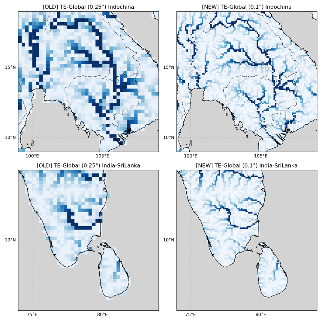
For reference, Figure 2 shows a comparison image of rivers as represented at the resolutions of the old and new TE-Global. As you can see, small rivers and tributaries that were lost in the old system due to its low resolution are now represented much more realistically in the new system. Regarding rivers, updating the grid size from about 25 km to about 10 km increased the number of rivers that the model can ideally resolve from about 230 to about 1,230 — an increase of more than fivefold.
Case study validation of flood estimation by New TE-Global: Sri Lanka floods in November 2025
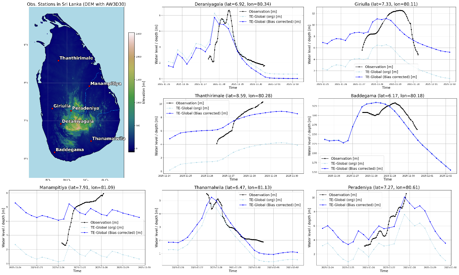
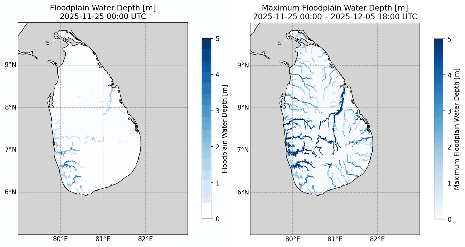
Flooding is one of the most obvious extreme phenomena among the variations in the water cycle that can be estimated by TE. On November 28, 2025, Cyclone “Ditwah” grazed the east coast of Sri Lanka, causing devastating floods and landslides and prompting the declaration of a state of emergency. Figures 3 and 4 show the simulation results for this case using the new TE-Global.
Figure 3 shows a comparison of observed water levels (black line) from river gauges installed at various locations in Sri Lanka with estimated river water levels (blue line) calculated by the new TE-Global system at the same locations. A sharp rise in water levels is observed at almost every location around November 28, and the new TE-Global estimates clearly capture this behavior. For the period near the cyclone’s approach, Figure 4 shows the time-series changes in inundation depth estimated by the new TE-Global (left) and the maximum value during that period (right). Compared with the inundation area estimated based on satellite observations (Figure 5), it can be seen that New TE-Global also estimates very large values across the northeastern to southwestern regions where a wide region was actually flooded.
Currently, estimation and prediction results from the new TE-Global are only available for monitoring on the website. However, we plan to compile long-term water cycle datasets covering past periods. In addition to case-by-case verification, we intend to perform long-term statistical validation, after which we will publish the data.

https://storymaps.arcgis.com/collections/8acb5761eefd4816bbb99f1e7146e6a2?item=1
Contribution to water disasters and water resource management in the world
In its “JAXA Fifth Mid- to Long-term Plan,” which outlines the direction for new research and development and operational activities over the seven-year period from April 2025 to March 2032, JAXA established four thematic strategic priorities for satellite Earth observation. One of these is “water disasters and water resources management.” By accelerating the development of satellite observation-related technologies such as Today’s Earth, we aim to contribute to countries and regions around the world facing challenges in this field. Today’s Earth aims to promote the use of satellite data, improve accuracy, and ultimately develop a global, high-resolution system that connects the global and local scales. To achieve this, we will conduct research and development in cooperation with relevant organizations.
*1:As of February 2026, under the Meteorological Service Act, TE-Japan forecast data are provided only to collaborative research partners (Information up to the present time is available for viewing on a publicly accessible webpage). The application for permission for flood forecasting operations is currently being processed. Also, TE-Global does not provide forecast values for rivers in Japan (displayed as masked).
Search by Year
Search by Categories


Tags
-
#Earthquake
-
#Land
-
#Satellite Data
-
#Aerosol
-
#Public Health
-
#GCOM-C
-
#Sea
-
#Atmosphere
-
#Ice
-
#Today's Earth
-
#Flood
-
#Water Cycle
-
#AW3D
-
#G-Portal
-
#EarthCARE
-
#Volcano
-
#Agriculture
-
#Himawari
-
#GHG
-
#GPM
-
#GOSAT
-
#Simulation
-
#GCOM-W
-
#Drought
-
#Fire
-
#Forest
-
#Cooperation
-
#Precipitation
-
#Typhoon
-
#DPR
-
#NEXRA
-
#ALOS
-
#GSMaP
-
#Climate Change
-
#Carbon Cycle
-
#API
-
#Humanities Sociology
-
#AMSR
-
#Land Use Land Cover
-
#Environmental issues
-
#Quick Report
-
#GOSAT-GW
Related Resources


Related Tags
Research and Development Related Articles
-
 Research and Development 2025.06.18 Wed Advancing Space-Based Weather Analysis and Forecasting – Renewal of JAXA’s Realtime Weather Watch ‘NEXRA3’ and Performance Evaluation with the previous system (Overview Article)
 -
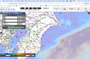 Research and Development 2025.03.27 Thu Launch of Ocean Weather Forecasts 1km resolution
 -
 Research and Development 2024.05.27 Mon The Use of Earth Observation Satellite Data in the Humanities and Social Sciences (3)
 -
 Research and Development 2024.03.06 Wed High sea surface temperatures in the Sea of Japan in relation to Typhoon No. 7, the only typhoon to hit Japan in 2023
Stay Connected
