


Research and Development
2025.06.18 Wed
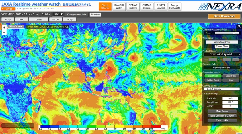
Advancing Space-Based Weather Analysis and Forecasting – Renewal of JAXA’s Realtime Weather Watch ‘NEXRA3’ and Performance Evaluation with the previous system (Overview Article)
To improve weather forecast accuracy and address increasingly severe meteorological disasters, JAXA collaborated with research teams from The University of Tokyo, RIKEN, and other institutions to develop the latest version of the NICAM-LETKF JAXA Research Analysis (NEXRA) experimental weather analysis system, called “NEXRA3”. NEXRA3 reproduces and predicts global atmospheric conditions at high resolution. JAXA launched a dedicated webpage for the system in July 2024.
In this article, we introduce the latest paper summarizing the scientific findings and provide an update on the frontiers of meteorological analysis, which continues to evolve through the integration of supercomputers and satellite observations.
Highlights of NEXRA3
- Significantly improved prediction accuracy: Compared to the previous version (NEXRA2), NEXRA3 shows substantial improvements in both the assimilation (one-year analysis) and forecast (five-day forecast) components.
- More realistic reproduction of cloud and precipitation: NEXRA3 provides more accurate simulations of precipitation amounts and spatial distribution by incorporating a high-resolution atmospheric model and a new cloud microphysics scheme.
- Enhanced capability to predict light rain: NEXRA3 improves the reproduction of light, steady rainfall – which was previously difficult to capture – leading to more practical precipitation forecasts.
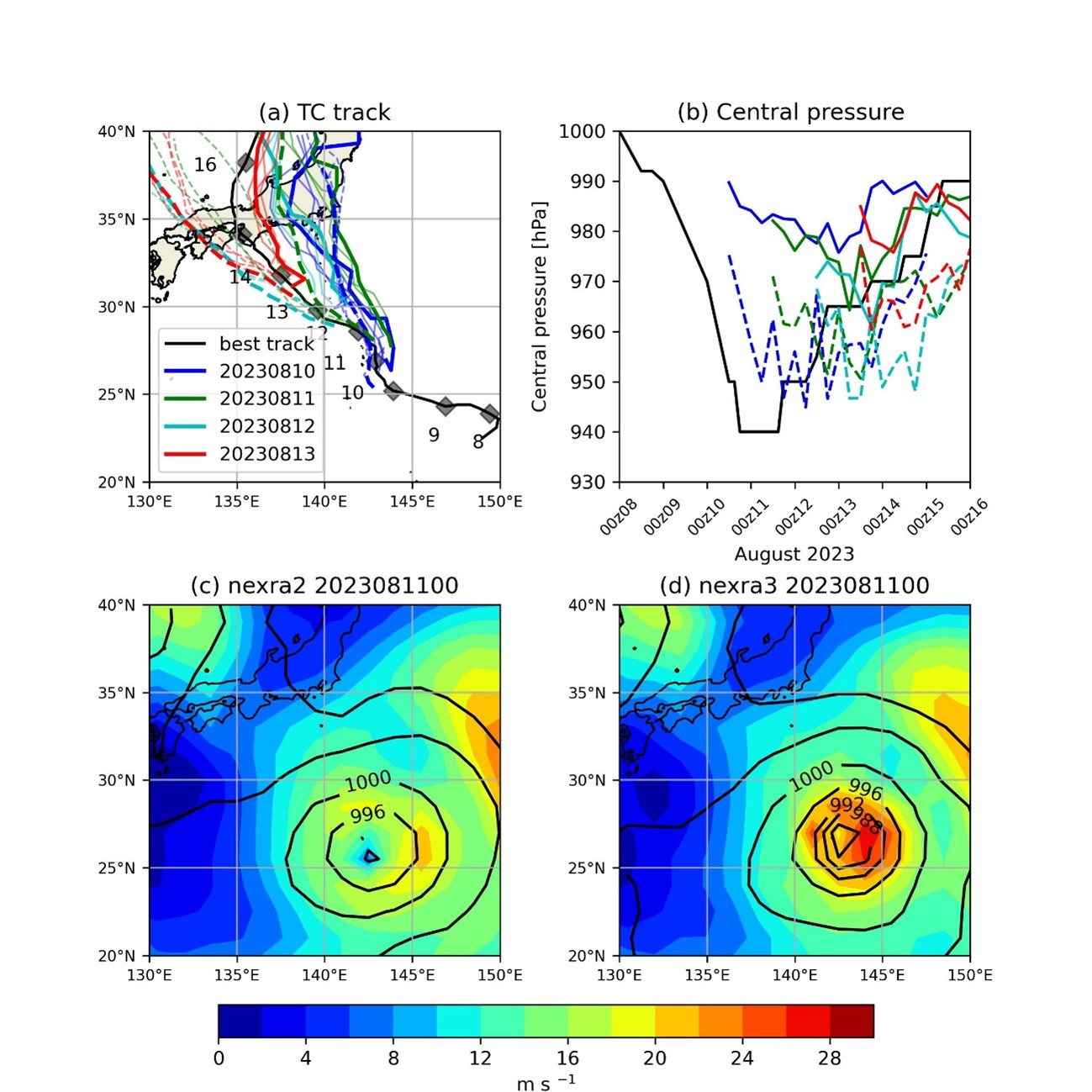
- Stronger capability for extreme weather events: For example, during Typhoon Lan (No. 7) in 2023, NEXRA3 more accurately reproduced the structure of the typhoon and associated precipitation area.
The entire planet is our laboratory – What is NEXRA?
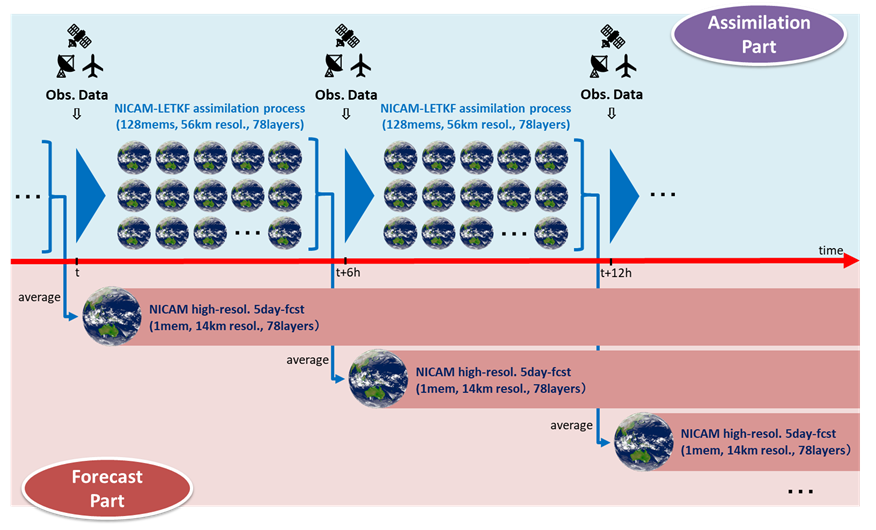
The NEXRA system uses the JAXA Supercomputer System (JSS) to accurately reproduce and predict the current and future state of the Earth’s atmosphere. Unlike standard weather forecasts, NEXRA assimilates satellite observation data from around the world, including the Global Satellite Mapping of Precipitation (GSMaP), and updates atmospheric conditions every six hours to accurately simulate future weather up to five days ahead.At the core of NEXRA are two advanced technologies.
- NICAM (Nonhydrostatic ICosahedral Atmospheric Model): A weather model developed in Japan that divides the Earth into an icosahedral grid, enabling uniform simulation accuracy across the global, including polar regions.
- LETKF (Local Ensemble Transform Kalman Filter): An advanced data assimilation technique that integrates observational data with numerical models to improve atmospheric state estimation.
NEXRA combines these two technologies to deliver near real-time atmospheric analysis and forecasting simultaneously.
What makes NEXRA3 so impressive?
The evolution of NEXRA has progressed in stages. The first generation was the NEXRA1, followed by the improved NEXRA2. The newly released NEXRA3 has made significant advances in the following points, resulting substantial improvement in overall accuracy.
1. Capturing more detailed observation data: Significant improvement in resolution
- Horizontal resolution: NEXRA performs simulations covering the entire Earth. In NEXRA3, the horizontal resolution for the simulation component has been enhanced from 112 km in NEXRA2 to 56 km in NEXRA3 for the assimilation part.
- Vertical resolution (Number of layers): The number of vertical layers of the atmosphere has increased from 38 layers (up to an altitude of 40 km) to 78 layers (up to an altitude of 50 km) in both the assimilation and forecast components. This allows for a more precise representation of the atmospheric vertical structure from the surface to the upper stratosphere.
As a result, NEXRA3 offers a more realistic depiction of phenomena such as clouds and precipitation. The system incorporates a model optimized for the supercomputer “Fugaku” integrating a variety of cutting-edge technologies. A detailed comparison between NEXRA2 and NEXRA3 is summarized in the supplement.
2. Reproducing the mechanisms of clouds and rain: Advancements in physical models
Conventional assimilation systems rely on approximate estimation for cloud and rain changes. NEXRA3, however, introduces a new cloud microphysics scheme called “NSW6-Roh,” which enables more accurate calculations of the transformation of water within clouds—such as the processes that lead to rain or snow.
In addition, the forecasting system incorporates a technique called “cumulus parameterization”, which dramatically improves the accuracy of light rain forecasts. This results in a more realistic spatial distribution of precipitation, particularly in regions that were previously underestimated.
To what extent has it actually improved?
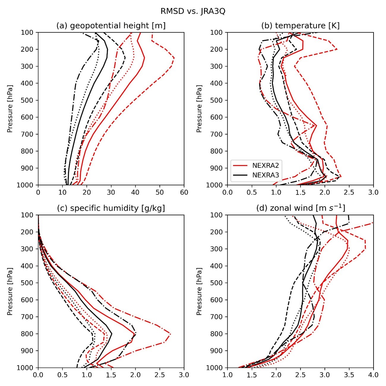
Increasing the resolution enables more accurate representation of meteorological fields.
In a one-year simulation comparison of the assimilation part, NEXRA3 outperformed its predecessor, NEXRA2, across nearly all major meteorological variables, including temperature, wind speed, humidity, and surface pressure. In particular, the accuracy of geopotential height (the height of a pressure level in the atmosphere), humidity, and wind speed has improved significantly, demonstrating its enhanced capability in capturing the structure and dynamics of the atmosphere.
A step forward in typhoon prediction
Using Typhoon Lan (No. 7), which hit Japan in August 2023, serves as a clear example of the improved forecasting capabilities of NEXRA3. In simulations of the forecast component, NEXRA3 shows superiority in reproducing the typhoon’s intensity, structure, and precipitation area. While NEXRA2 displayed errors, such as the abrupt weakening of the typhoons near landfall, NEXRA3 more accurately depicts interactions with the Earth’s surface and cloud structure, leading to a more realistic representation of the storm’s evolution.
Prospects for the next generation: Future weather forecasts powered by satellites and supercomputers
While NEXRA3 is a research analysis system distinct from the operational forecast models used by the Japan Meteorological Agency, its advancements are paving the way for more accurate future weather forecasts. In particular, the ability to fully utilize satellite observation data (such as GSMaP) makes a major milestone in data assimilation research. The model structure for predicting cloud and precipitation particles is also compatible with assimilate satellite radar observations, making it well-suited for assimilating data from EarthCARE and upcoming satellite missions.
Looking ahead, the goal is to establish an ultra-high resolution, 1-km-scale forecast cycle. This will enable a more detailed understanding and prediction of extreme weather events, including heavy rainfall and typhoons.
Summary
In parallel with research into improving the accuracy of Earth observation data from satellites, JAXA is collaborating with universities and other institutions to integrate these data with numerical simulations using supercomputers, aiming to maximize the strength of both approaches. NEXRA3 is the culmination of these efforts, representing a cutting-edge system for weather analysis and forecasting. Forecast results from NEXRA3 are available on JAXA’s official NEXRA website, accessible to researchers, disaster prevention authorities, and the general public. Anyone can view daily forecast data. The system also supports applied platforms such as “Today’s Earth” and “GSMaP RIKEN nowcast”, contributing to flood forecasting and disaster prevention and infrastructure planning.
JAXA will continue to provide highly accurate Earth observation data from satellites and integrate it with advanced numerical simulations to deepen our understanding of atmospheric processes. By providing more accurate information, these efforts will support daily safety and contribute to building a more resilient and sustainable future. The next generation of weather forecasting is already underway.
Supplement: Differences between NEXRA2 and NEXRA3
| System | NEXRA2 | NEXRA3 |
|---|---|---|
| NICAM version | version 19.2 | version 21.3 |
| Assimilation Model | ||
| Horizontal resolution | 112km | 56km |
| Vertical layer | 38 layers (up to 40km altitude) | 78 layers (up to 50km altitude) |
| Cloud microphysics | Coagulation process only | NSW6-Roh Scheme |
| Handling of precipitation | Diagnostic type | Prognostic type (accounts for particle types such as rain, snow, graupel, etc.) |
| Handling of cumulus (cumulus parameterization) | Diagnostic type, Arakawa-Schubert Scheme | Chikira-Sugiyama Scheme |
| Forecast Model | ||
| Horizontal resolution | 14km | 14km |
| Vertical layer | 38 layers (up to 40km altitude) | 78 layers (up to 50km altitude) |
| Cloud microphysics | NSW6 Scheme | NSW6-Roh Scheme |
| Handling of precipitation | Prognostic type (considering particle types such as rain, snow, graupel, etc.) | Prognostic type (considering particle types such as rain, snow, graupel, etc.) |
| Handling of cumulus (cumulus parameterization) | Not applied | Chikira-Sugiyama Scheme |
Scientific source cited in the article
Published in the Meteorological Society of Japan, SOLA (Scientific Online Letters on the Atmosphere), 2025
Paper title:
Intercomparison of NICAM-LETKF JAXA Research Analysis (NEXRA) version 2 and 3
Authors:
Shuhei Matsugishi1, Ying-Wen Chen1, Koji Terasaki2,3, Hisashi Yashiro4,3, Shunji Kotsuki5,3, Kaya Kanemaru6, Kosuke Yamamoto7, Masaki Satoh1,8, Takuji Kubota7, Takemasa Miyoshi3,9,10
1 Atmosphere and Ocean Research Institute, The University of Tokyo, 2 Meteorological Research Institute, Japan Meteorological Agency, 3 RIKEN Center for Computational Science,
4 National Institute for Environmental Studies, 5 Institute for Advanced Academic Research (IAAR), Chiba University, 6 National Institute of Information and Communications Technology, 7 Earth Observation Research Center, Japan Aerospace Exploration Agency, 8 Typhoon Science and Technology Research Center, Yokohama National University, 9 RIKEN Cluster for Pioneering Research, 10 RIKEN Interdisciplinary Theoretical and Mathematical Sciences Program (iTHEMS)
DOI:
https://doi.org/10.2151/sola.2025-035
Responsibility for the content:Masaki Satoh, Shuhei Matsugishi, Mayumi Yoshioka(Atmosphere and Ocean Research Institute, The University of Tokyo)
Related Sites
Search by Year
Search by Categories


Tags
-
#Earthquake
-
#Land
-
#Satellite Data
-
#Aerosol
-
#Public Health
-
#GCOM-C
-
#Sea
-
#Atmosphere
-
#Ice
-
#Today's Earth
-
#Flood
-
#Water Cycle
-
#AW3D
-
#G-Portal
-
#EarthCARE
-
#Volcano
-
#Agriculture
-
#Himawari
-
#GHG
-
#GPM
-
#GOSAT
-
#Simulation
-
#GCOM-W
-
#Drought
-
#Fire
-
#Forest
-
#Cooperation
-
#Precipitation
-
#Typhoon
-
#DPR
-
#NEXRA
-
#ALOS
-
#GSMaP
-
#Climate Change
-
#Carbon Cycle
-
#API
-
#Humanities Sociology
-
#AMSR
-
#Land Use Land Cover
-
#Environmental issues
-
#Quick Report
-
#GOSAT-GW
Related Resources


Related Tags
Research and Development Related Articles
-
 Research and Development 2026.03.09 Mon High-Resolution Predictions of Global Terrestrial Water Cycle:
Today’s Earth – Global Updated -
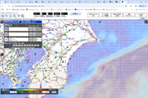 Research and Development 2025.03.27 Thu Launch of Ocean Weather Forecasts 1km resolution
 -
 Research and Development 2024.05.27 Mon The Use of Earth Observation Satellite Data in the Humanities and Social Sciences (3)
 -
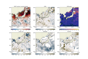 Research and Development 2024.03.06 Wed High sea surface temperatures in the Sea of Japan in relation to Typhoon No. 7, the only typhoon to hit Japan in 2023
Stay Connected
