


Research and Development
2025.03.27 Thu
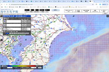
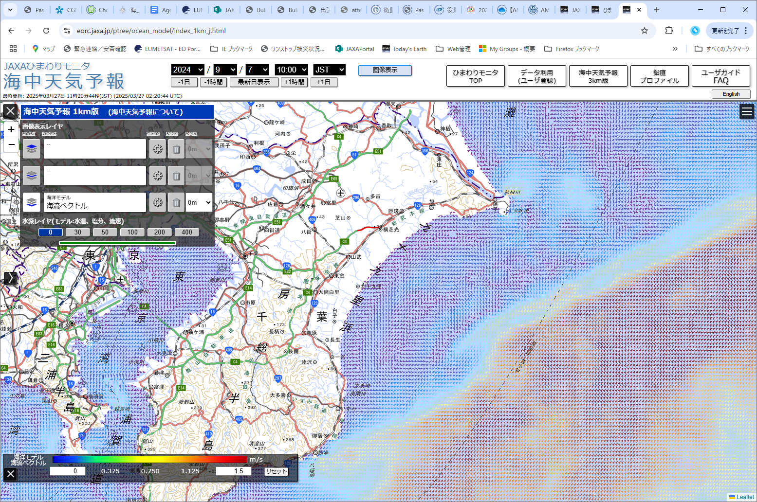
Launch of Ocean Weather Forecasts 1km resolution
1. Introduction
We have launched a new website “Ocean Weather Forecasts”, which provides current ocean conditions around Japan and forecasts for the next few days at 1km resolution and hourly intervals.
To combine satellite ocean observations and ocean models, JAXA and the Japan Agency for Marine-Earth Science and Technology (JAMSTEC) Application Laboratory (APL) have been releasing Ocean Weather Forecasts with a spatial resolution of approximately 3 km around Japan (JCOPE-T DA) since 2018. The forecast data was created by combining JAXA’s satellite sea surface temperature data with JAMSTEC’s ocean circulation model, JCOPE-T.
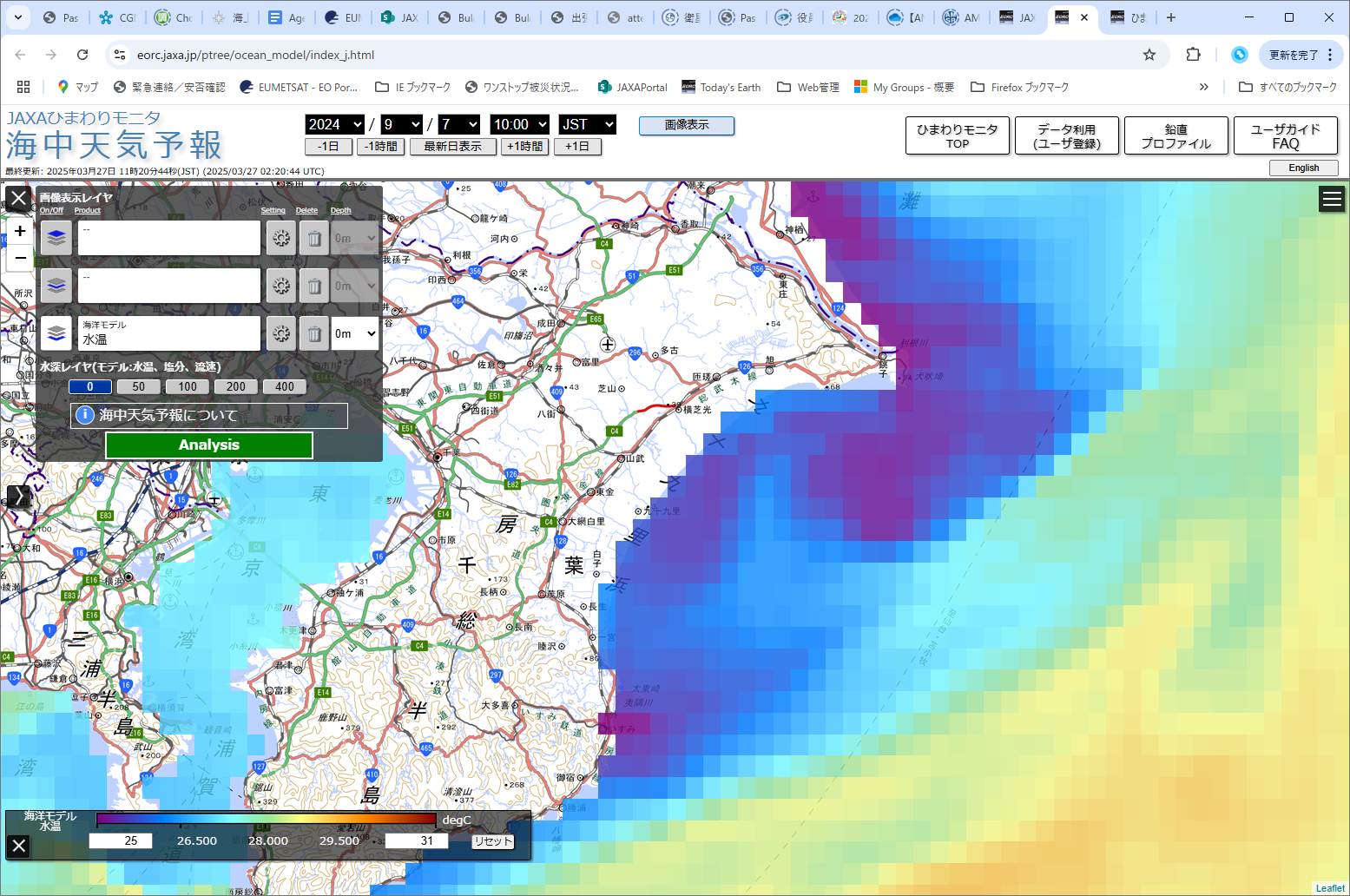
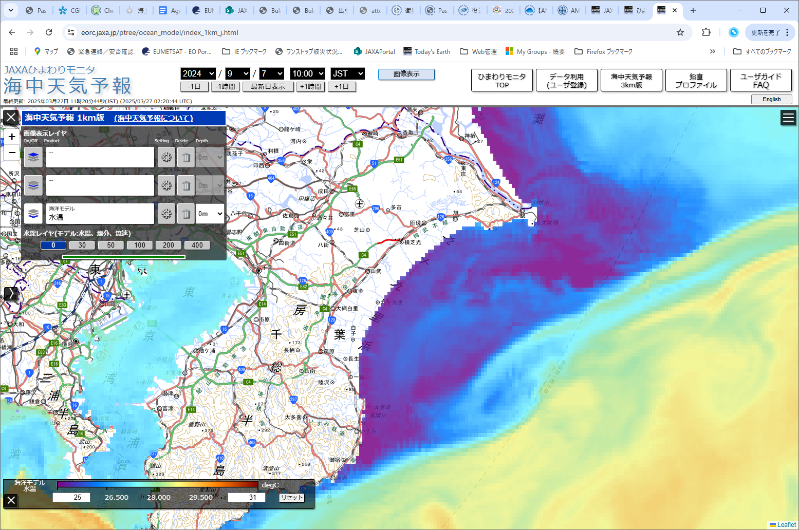
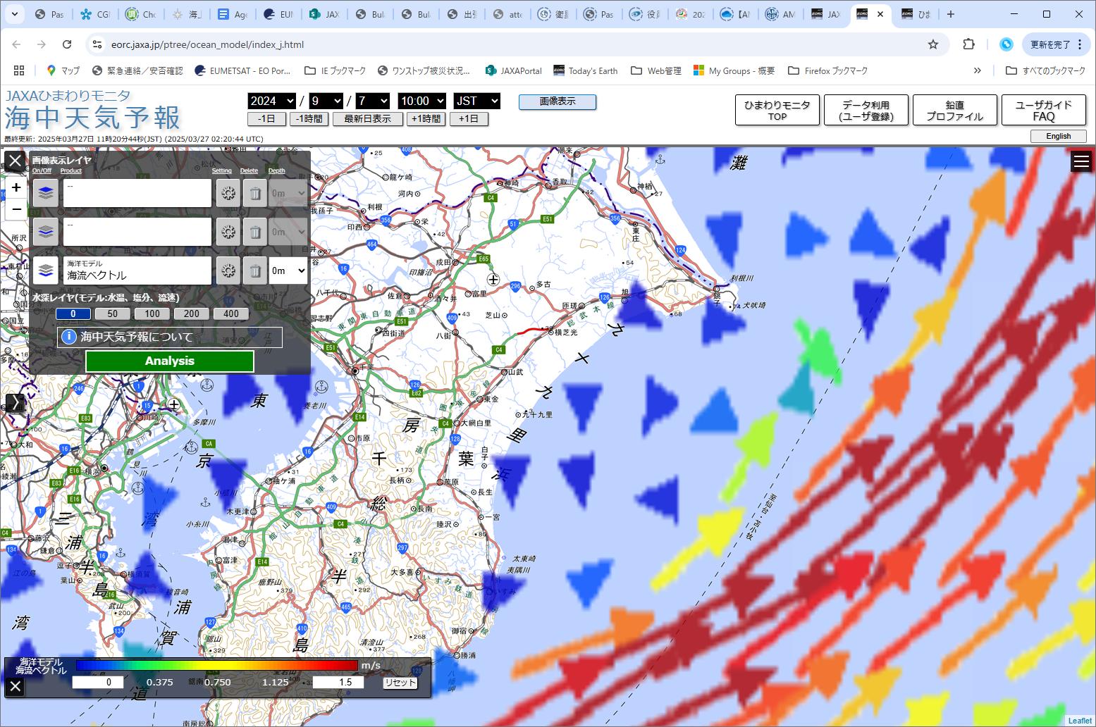
A new Ocean Weather Forecasts website (Figures 1 and 2) with improved spatial resolution of approximately 1 km (JCOPE-T 1ks) has been available since March 27, 2025. JAMSTEC developed JCOPE-T 1ks (see Section 2), and JAXA validated and evaluated the data using satellite and in-situ observations (see Section 3) and built the visualization website (see Section 1).
The new website also includes the following features:
- When zoomed in, ocean current vectors can be displayed in detail without thinning out.
- Minimum and maximum values of the color bar for the current vector can be changed
- Time series graph of any point can be displayed
The 3km resolution Ocean Weather Forecasts website will also continue to operate in parallel.
 |
 |
 |
 |
| Figure 1. Water temperature (top) and ocean current vectors (bottom) at a depth of 0 m in Tokyo Bay and off the coast of Choshi using the current JCOPE-T DA (3 km resolution). Ocean current vectors are thinned out. | Figure 2. Water temperature (top) and ocean current vectors (bottom) at 0m depth in Tokyo Bay and off the coast of Choshi using the new JCOPE-T 1ks (1km resolution) |
2. JCOPE-T 1ks System
JAMSTEC APL is conducting research and development of Ocean Weather Forecasts [1] as part of the Japan Coastal Ocean Predictability Experiment (JCOPE). JCOPE-T 1ks (1km scale: approximately 1km resolution) [2] is an Ocean Weather Forecasts system that is a higher-resolution version of the currently available JCOPE-T DA (Data Assimilation: approximately 3km resolution) [3]. The underlying ocean circulation models for both are JCOPE-T [4]. A comparison of JCOPE-T DA and JCOPE-T 1ks is shown in Table 1. For more information about the JCOPE-T 1ks system, please see here.
| JCOPE-T DA (Current) | JCOPE-T 1ks (New) | |
| Simulation Period | 2018 – Present | 2024 – Present |
| Domain | 17.0°-50.0° N 117.0°-150.0° E |
17.5°-49.5° N 117.5°-149.5° E |
| Temporal Resolution | 1 hour | 1 hour |
| Horizontal Resolution | 1/36°(~3km) | 1/120°(~900m) |
| Vertical Levels | 46 | 46 |
| Bathymetry | SRTM + nautical charts, smoothed according to horizontal resolution | SRTM + nautical charts, smoothed according to horizontal resolution |
| Atmospheric Forcing | NCEP GFS | NCEP GFS |
| Tidal Forcing | 11 tidal constituents(K1, O1, P1, Q1, K2, M2, N2, S2, M4, MN4, and MS4) | 11 tidal constituents(K1, O1, P1, Q1, K2, M2, N2, S2, M4, MN4, and MS4) |
| Lateral Boundary Conditions | JCOPE2M | JCOPE-T DA |
| River Discharge | Japan : JAXA Today’s Earth Japan(368 rivers) Other regions ; monthly climatology | Japan : JAXA Today’s Earth Japan(368 rivers) Other regions ; monthly climatology |
| Data Assimilation | Daily assimilation satellite sea of surface height, satellite sea surface temperature, and in-situ temperature and salinity using multiscale 3DVAR | Temperature and salinity fields are adjusted to be consistent with those of JCOPE-T DA. No adjustment is applied in areas shallower than 200 m |
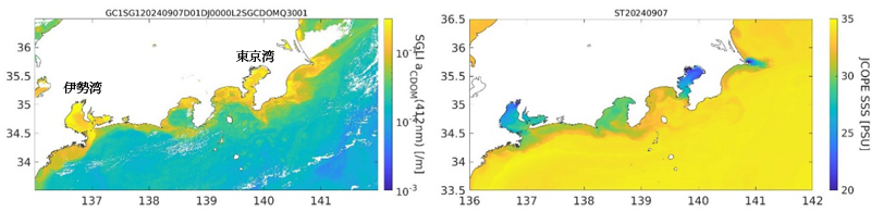
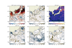
3. Spatial distribution validation using GCOM-C/SGLI ocean products
For the heavy rainfall in the Kyushu-Kanto region caused by Typhoon No. 10 in 2024, we used the light absorption coefficient of dissolved organic matter (aCDOM)[5], an SGLI ocean standard product, as a tracer in freshwater to compare the spatial distribution of sea surface salinity (SSS) from JCOPE-T 1ks (Figure 3).
JCOPE-T 1ks correctly reproduced the trend of decreasing salinity caused by river flooding and was able to reproduce detailed horizontal gradients, especially in semi-enclosed bays such as Tokyo Bay and Ise Bay, which were difficult to reproduce with conventional model resolution. Such high-resolution analysis results from JCOPE-T 1ks are expected to be utilized as a valuable tool for delivering ocean condition information to coastal environmental conservation and to the fisheries sector. On the other hand, problems such as underestimation of sea surface temperatures due to errors in the river boundary conditions have been identified (See here for more details). Currently, it is recommended that the data be used in conjunction with actual observation data from satellites, etc., but JAXA and JAMSTEC APL plan to continue collaborating on research to improve it.
Reference:
[1] H. Hayashida, Y. Miyazawa, T. Miyama, Y. Baba and S. Kido, 2024: Ocean weather forecasts, Oceanography in Japan, 33, 89-101.
https://kaiyo-gakkai.jp/jos/uminokenkyu/vol33/33-5_6/33-56-3_hayashida.pdf
[2] Wang, S., S. Kido, X. Guo, Y. Miyazawa, and S, M. Varlamov, 2025: Topographically generated submesoscale processes in the Tokara Strait revealed by a high-resolution model, in revision.
[3] Miyazawa, Y., S. M. Varlamov, T. Miyama, Y. Kurihara, H. Murakami, and M. Kachi, 2021: A nowcast/forecast system for Japan’s coasts using daily assimilation of remote sensing and in situ data Remote Sensing, 13, 2431.
https://www.mdpi.com/2072-4292/13/13/2431
[4] Varlamov, S. M. , and Miyazawa (2021) High-performance computing of ocean models for Japan Coastal Ocean Predictability Experiment: a parallelized sigma-coordinate ocean circulation model JCOPET. Annual Report of the Earth Simulator, April 2020-Feb 2021, 1–3.
https://www.jamstec.go.jp/es/jp/output/publication/annual/annual2020/pdf/2project/chapter2/II-3_miyazawa.pdf
[5] Takafumi, Hirata and Yohei, Yamashita “Derivation of the absorption coefficient of Colourd Dissolved Organic Matter (CDOM)” SGLI Algorithm Technical Background Document (2020).
Search by Year
Search by Categories


Tags
-
#Earthquake
-
#Land
-
#Satellite Data
-
#Aerosol
-
#Public Health
-
#GCOM-C
-
#Sea
-
#Atmosphere
-
#Ice
-
#Today's Earth
-
#Flood
-
#Water Cycle
-
#AW3D
-
#G-Portal
-
#EarthCARE
-
#Volcano
-
#Agriculture
-
#Himawari
-
#GHG
-
#GPM
-
#GOSAT
-
#Simulation
-
#GCOM-W
-
#Drought
-
#Fire
-
#Forest
-
#Cooperation
-
#Precipitation
-
#Typhoon
-
#DPR
-
#NEXRA
-
#ALOS
-
#GSMaP
-
#Climate Change
-
#Carbon Cycle
-
#API
-
#Humanities Sociology
-
#AMSR
-
#Land Use Land Cover
-
#Environmental issues
-
#Quick Report
-
#GOSAT-GW
Related Resources


Related Tags
Research and Development Related Articles
-
 Research and Development 2026.03.09 Mon High-Resolution Predictions of Global Terrestrial Water Cycle:
Today’s Earth – Global Updated -
 Research and Development 2025.06.18 Wed Advancing Space-Based Weather Analysis and Forecasting – Renewal of JAXA’s Realtime Weather Watch ‘NEXRA3’ and Performance Evaluation with the previous system (Overview Article)
 -
 Research and Development 2024.05.27 Mon The Use of Earth Observation Satellite Data in the Humanities and Social Sciences (3)
 -
 Research and Development 2024.03.06 Wed High sea surface temperatures in the Sea of Japan in relation to Typhoon No. 7, the only typhoon to hit Japan in 2023
Stay Connected
