


Latest Observation
2024.09.24 Tue
Arctic sea-ice extent reaches annual minimum on September 13, 2024
〜Fifth lowest in the history of satellite observations〜
September 24, 2024
Japan Aerospace Exploration Agency
National Institute of Polar Research
As part of the Arctic Challenge for Sustainability II (ArCS II*1), the Japan Aerospace Exploration Agency (JAXA) and the National Institute of Polar Research (NIPR) have visualized temporal and spatial changes in sea-ice extent in the Northern and Southern Hemispheres based on observation data from the Advanced Microwave Scanning Radiometer 2 (AMSR2) onboard the Global Change Observation Mission – Water “SHIZUKU” (GCOM-W), and have made the data available on the Arctic Data archive System (ADS*2) website.
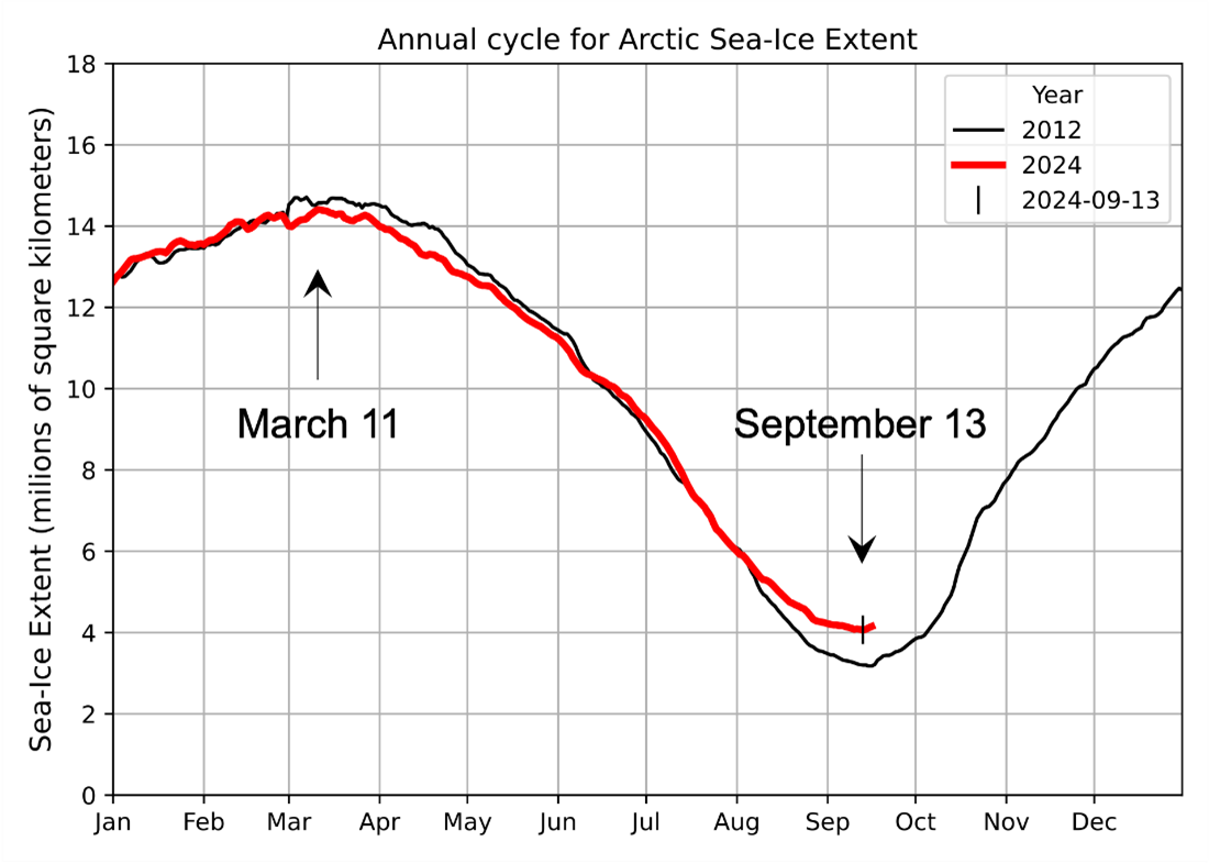
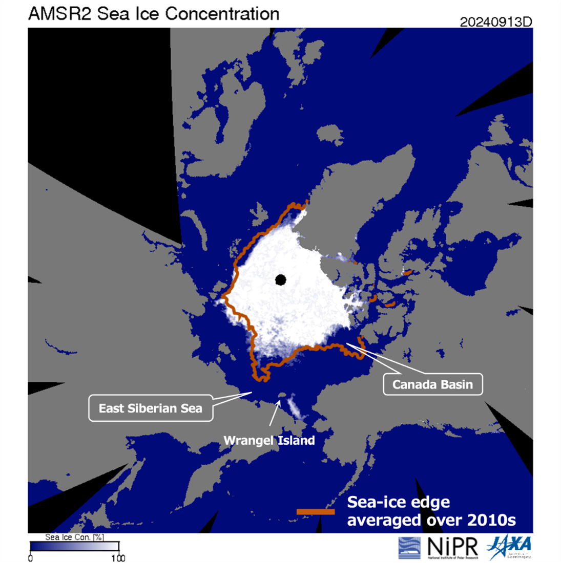
Analysis of sea-ice data for 2024 revealed that the Arctic sea-ice extent*3 recorded its annual minimum (4.07 million square kilometers) on September 13. This sea-ice extent is the fifth lowest in the history of satellite observations (tied with the 2007 record). After reaching the winter maximum sea-ice extent (14.41 million square kilometers) on March 11, 2024, the sea-ice extent remained lower than that of 2012 (3.18 million square kilometers), the lowest year in satellite observation history, until early June. Although a new record was expected for the first time in 12 years, the pace of sea-ice retreat slowed in early August (Figure 1). The sea-ice distribution on September 13, 2024 (Figure 2) shows that a significant sea-ice retreat occurs off the coast of the East Siberian Sea and in the Canada Basin, compared to the average ice edge position in the 2010s (brown line).
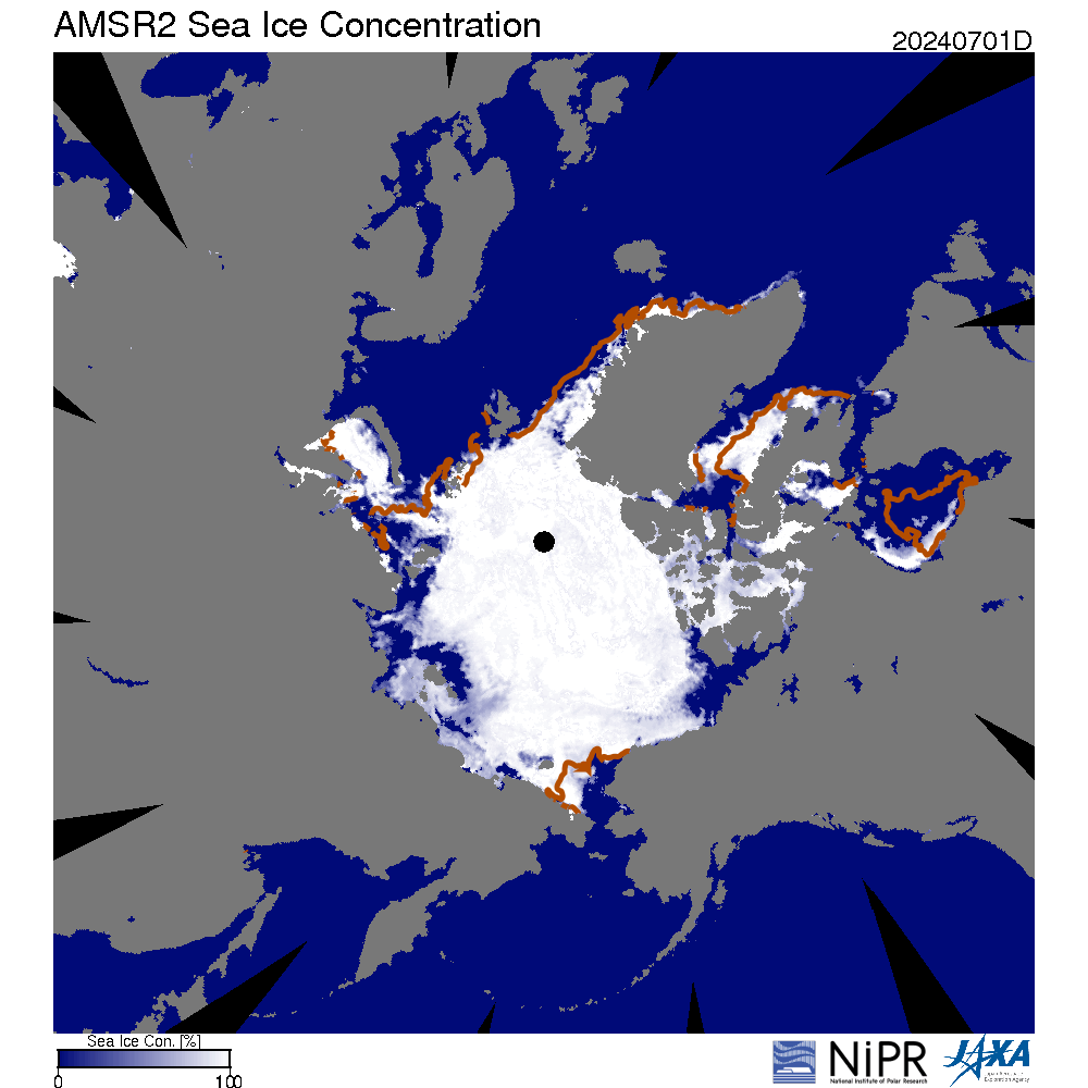
One of the most notable features of the 2024 sea-ice distribution is the persistence of sea ice on the eastern side of Wrangel Island. It is noted that the total sea-ice extent would not fall below the record low observed in 2012 even without this remaining sea ice. Animations of the daily sea-ice distribution from July to September show that the sea-ice tongue extending toward the East Siberian Sea coast gradually contracted due to melting until August. However, sea ice remained around Wrangel Island until September, when freezing had begun. The persistence of sea ice in this region is thought to be due to thickening sea ice caused by strong convergence during the spring. Additionally, the lower-than-average temperature in the East Siberian Sea in August may have further suppressed sea-ice melting. It is the first time in 24 years, since 2000, that sea ice has remained around Wrangel Island, and the first time it has remained in an isolated state.
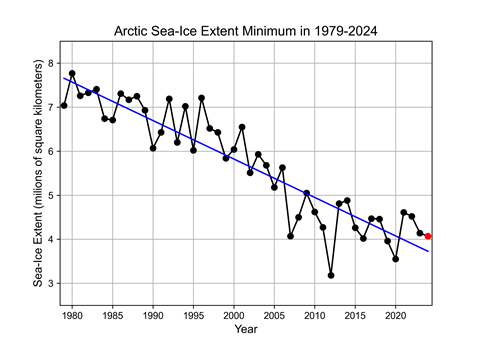
Regarding the long-term trends in the annual minimum sea-ice extent, data from 1979 to 2024 shows that the Arctic sea-ice extent is declining by approximately 87,000 square kilometers per year (roughly equivalent to the area of Hokkaido) (Figure 3). Although the extent of summer sea ice in the Arctic Ocean varies greatly from year to year, the long-term declining trend is expected to continue. Since sea ice loss has the potential to affect the Arctic ecosystem and climate system, it is necessary to monitor it carefully and analyze its factors. JAXA plans to launch the Global Observing SATellite for Greenhouse gases and Water cycle (GOSAT-GW), which will be equipped with the Advanced Microwave Scanning Radiometer 3 (AMSR3), the successor to the AMSR2, in fiscal year 2025. The data will be used to continue and develop further long-term monitoring.
*1: Arctic Challenge for Sustainability II (ArCS II)
National Arctic research projects led by the National Institute of Polar Research. Researchers in the natural sciences, engineering, humanities, and social sciences participate in this project, which aims to contribute to the realization of a sustainable society through collaboration with different research fields and society and international cooperation based on an accurate understanding of the actual situation and mechanisms of global warming and future projections. The implementation period is from June 2020 to March 2025.
*2: The Arctic Data archive System (ADS)
A data archive system for preserving and managing observation data and model simulation products obtained in the Antarctic and Arctic regions through the GRENE Arctic Climate Change Research Project (2011-2016), Arctic Challenge for Sustainability (ArCS, 2015- 2020), and ArCS II.
*3: The sea-ice extent is defined as a temporal average of several days to eliminate calculation errors due to a lack of data. In this article, we adopt an average of five days. The ADS (https://ads.nipr.ac.jp/vishop/#/extent) provides preliminary figures for the 2-day average.
Search by Year
Search by Categories


Tags
-
#Earthquake
-
#Land
-
#Satellite Data
-
#Aerosol
-
#Public Health
-
#GCOM-C
-
#Sea
-
#Atmosphere
-
#Ice
-
#Today's Earth
-
#Flood
-
#Water Cycle
-
#AW3D
-
#G-Portal
-
#EarthCARE
-
#Volcano
-
#Agriculture
-
#Himawari
-
#GHG
-
#GPM
-
#GOSAT
-
#Simulation
-
#GCOM-W
-
#Drought
-
#Fire
-
#Forest
-
#Cooperation
-
#Precipitation
-
#Typhoon
-
#DPR
-
#NEXRA
-
#ALOS
-
#GSMaP
-
#Climate Change
-
#Carbon Cycle
-
#API
-
#Humanities Sociology
-
#AMSR
-
#Land Use Land Cover
-
#Environmental issues
-
#Quick Report
-
#GOSAT-GW
Related Resources


Related Tags
Latest Observation Related Articles
-
 Latest Observation 2026.06.05 Fri [Quick Report] Typhoon No. 6, “JANGMI”, brought heavy rain to Japan. – Results of satellite data analysis –
 -
 Latest Observation 2026.04.16 Thu [Quick Report] EarthCARE Captured the Eye of Typhoon Sinlaku
 -
 Latest Observation 2025.12.03 Wed [Quick Report] Analysis results from satellite precipitation data on the record-breaking heavy rainfall occurring in Southeast Asia in late November 2025
 -
 Latest Observation 2025.10.01 Wed [Quick Report] Hurricane Humberto “Eye” captured by EarthCARE satellite (Hakuryu)
Stay Connected
