


Research and Development
2022.06.09 Thu
Data provision service “JAXA Earth API” is now available!
1. “JAXA Earth API” for providing Earth observation satellite image data
JAXA/EORC has developed the “JAXA Earth API” service to provide a wide variety of JAXA Earth observation satellite image data in an easy-to-use format and to promote the efficient and effective use of satellite data. By using JAXA Earth API, users can acquire, process, and visualize data more freely and efficiently through web applications and APIs, without being aware of differences in satellite data formats. A prototype version is now available [1].
Please click following banner if you would like to check JAXA Earth API portal site.

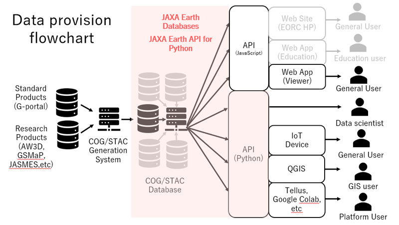
The JAXA Earth API service consists of three main components: an API (Python language version, popular in fields such as data science, and a JavaScript language version (under development) for browser applications), a database, and a web application.
As shown in Figure 1, this system has the scalability to develop into a data distribution infrastructure. Specifically, the system can be expanded to include additional databases, direct use of data through web applications using APIs, etc.
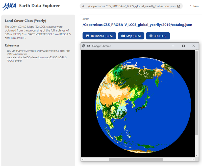
1.1. JAXA Earth Data Explorer
This is a browser application that allows you to check various satellite data stored in a database [2]. Please click following banner if you would like to check JAXA Earth Data Explorer.

It implements functions such as the ability to display data by switching time series, 3D display, etc.
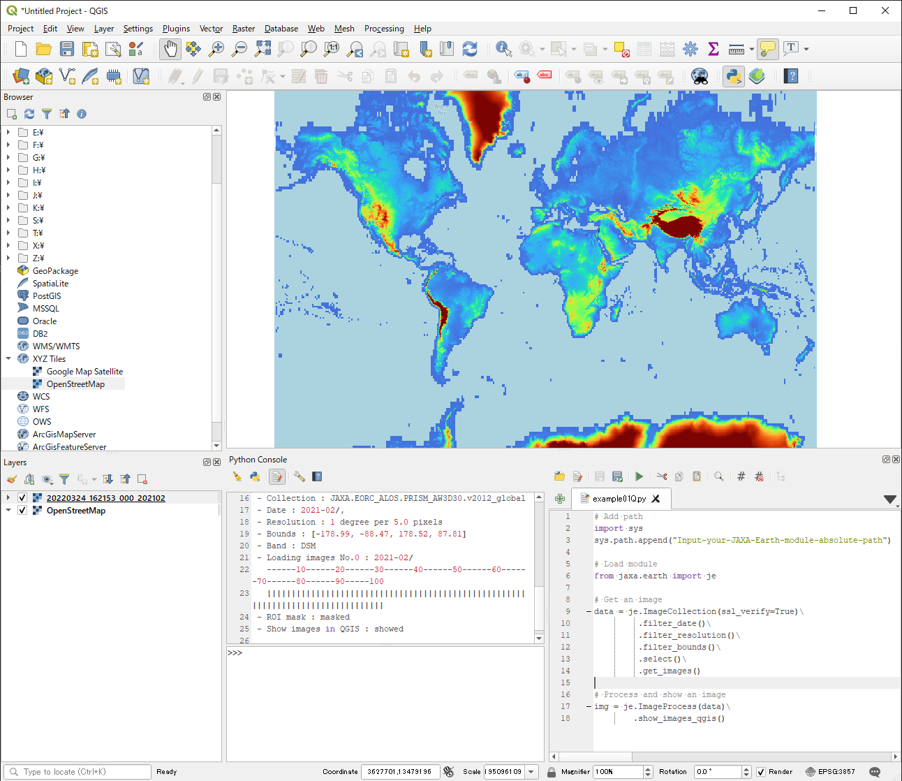
1.2. JAXA Earth API for Python
The JAXA Earth API for Python allows users to efficiently, effectively, and freely acquire and use satellite data for any area, without being aware of differences in satellite, sensor type, resolution, etc.
Please click following banner if you would like to install JAXA Earth API for Python.

The API also has an IF function with the free GIS software QGIS, allowing for immediate acquisition and display of data. For obtaining API and the detailed specification and function, please see API reference [3].
1.3. JAXA Earth Database
The database contains 74 types of data including elevation, surface temperature, vegetation index, precipitation, and land cover classification maps. The database contains data and metadata based on COG (*1)/STAC (*2), a global standard specification. The details of COG/STAC specifications in this database are described on the API reference page.
*1 … COG (Cloud Optimized GeoTIFF) is a TIFF file format that contains tiled, multi-resolution data in a single file. http range request makes it possible to retrieve only the necessary data with the minimum traffic required.
*2 … STAC (Spatio Temporal Asset Catalog) is a file that stores metadata of geospatial information such as satellite data and its storage location in a hierarchical manner. Since the information is machine-readable catalog information, data retrieval and access can be automated.
2. Advantages of the data provision method using the data provision service “JAXA Earth API”
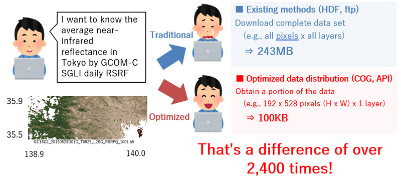
Figure 4 shows an example of data use of SHIKISAI (GCOM-C) in the conventional data distribution method. In the past, the data could only be visualized after searching for the target data, downloading the entire file from an ftp site, and performing tasks such as map projection and engineering value conversion. Since knowledge of remote sensing is required, the use of this system has been limited to a small number of users.
On the other hand, when using this API (and database), the user only needs to enter the product of interest, date range, area of interest, etc. in the API query to identify the product and obtain data only for the band of interest, surrounding area, and resolution of interest. This allows for significant efficiency gains through data traffic savings and reduced time to data acquisition.
3. Secretariat and contact information
If you have any inquiries and comments about the data provision service “JAXA Earth API”, or if you would like to contact us for publication of your research results, please send an e-mail to the contact address below. We would appreciate it if you could also provide us with examples of your use of the service, to the extent possible, so that we can continue the development of “JAXA Earth API”.
![]()
![]()
![]()
![]()
(JAXA Earth API Secretariat)
4. How to use the API and references
[1] JAXA Earth API
https://data.earth.jaxa.jp
[2] JAXA Earth Data Explorer
https://data.earth.jaxa.jp/app/explorer
[3] JAXA Earth API for Python and API reference
https://data.earth.jaxa.jp/api/python
[4] JAXA Earth : Prototype of Earth Observation Data Distribution System and Application for Interdisciplinary Studies
https://doi.org/10.36463/idw.2021.0622
Search by Year
Search by Categories


Tags
-
#Earthquake
-
#Land
-
#Satellite Data
-
#Aerosol
-
#Public Health
-
#GCOM-C
-
#Sea
-
#Atmosphere
-
#Ice
-
#Today's Earth
-
#Flood
-
#Water Cycle
-
#AW3D
-
#G-Portal
-
#EarthCARE
-
#Volcano
-
#Agriculture
-
#Himawari
-
#GHG
-
#GPM
-
#GOSAT
-
#Simulation
-
#GCOM-W
-
#Drought
-
#Fire
-
#Forest
-
#Cooperation
-
#Precipitation
-
#Typhoon
-
#DPR
-
#NEXRA
-
#ALOS
-
#GSMaP
-
#Climate Change
-
#Carbon Cycle
-
#API
-
#Humanities Sociology
-
#AMSR
-
#Land Use Land Cover
-
#Environmental issues
-
#Quick Report
-
#GOSAT-GW
Related Resources


Related Tags
Research and Development Related Articles
-
 Research and Development 2026.03.09 Mon High-Resolution Predictions of Global Terrestrial Water Cycle:
Today’s Earth – Global Updated -
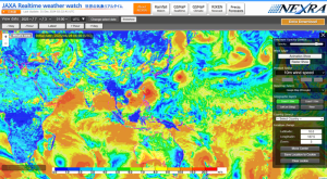 Research and Development 2025.06.18 Wed Advancing Space-Based Weather Analysis and Forecasting – Renewal of JAXA’s Realtime Weather Watch ‘NEXRA3’ and Performance Evaluation with the previous system (Overview Article)
 -
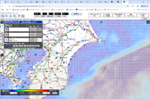 Research and Development 2025.03.27 Thu Launch of Ocean Weather Forecasts 1km resolution
 -
 Research and Development 2024.05.27 Mon The Use of Earth Observation Satellite Data in the Humanities and Social Sciences (3)
Stay Connected
