


Meteorology and the Environment
2022.04.22 Fri
Earth Day ~Caring about our Earth~
“The disappearing lake, and the appearing crater”
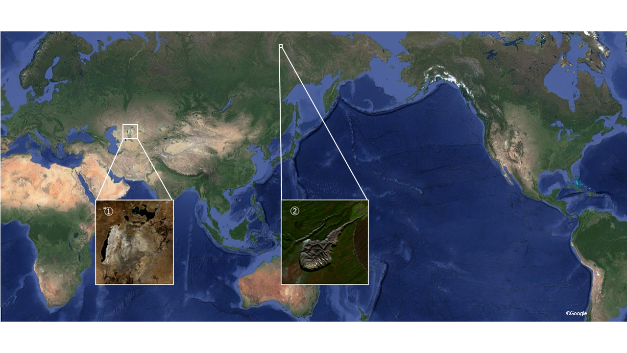
Earth Day is an annual event held on April 22 to demonstrate support for environmental protection. In honor of “Earth Day”, ①The disappearing lake “Aral sea” in Kazakhstan, ②The appearing crater “Batagaika” in Russia, will be introduced by the satellite images in this article.
①The disappearing lake “Aral sea”
 |
 |
 |
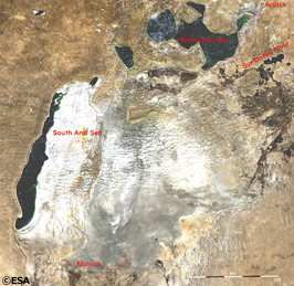
| Fig.①-1 October 2003 ADEOS-Ⅱ |
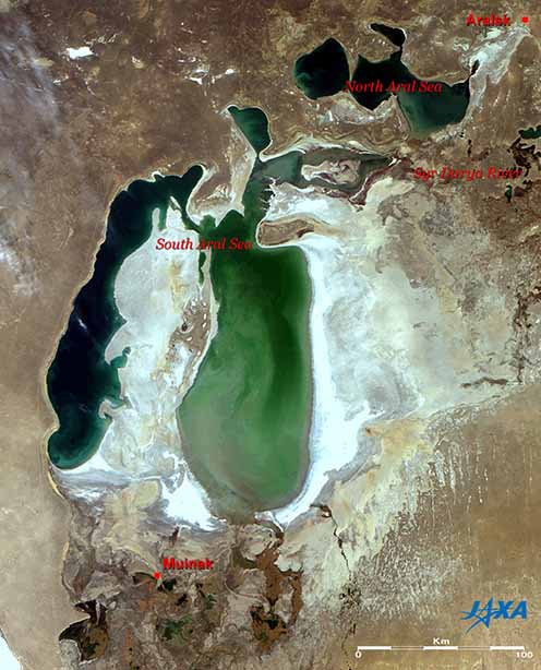
Fig.①-2 September 2006 – October 2007 ALOS |
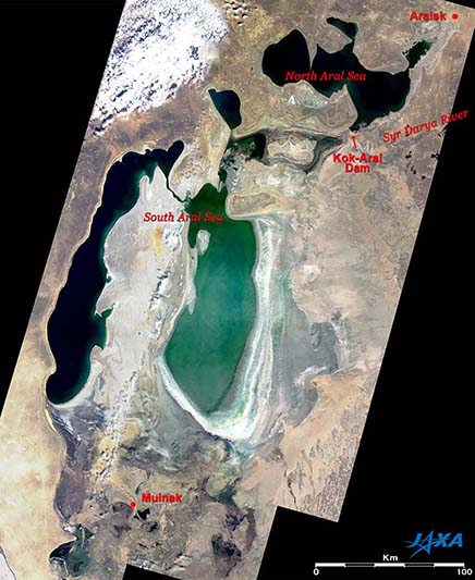
Fig.①-3 September 2021 Sentinel-2 |
This section is referred to the following articles in 2004 and 2007.
Click here for the 2004 article
Click here for the 2007 article
The Aral Sea from 2003 to 2021 is shown in Fig.①-1 to Fig.①-3. The Aral Sea extends across Kazakhstan to Uzbekistan, and formerly had 100 times larger area than Lake Biwa in Japan. As the world’ s fourth largest lake, it had an abundance of water in the arid region.
However, since 1999, the lake water level has been declining year by year, and the area has continued to shrink. It is said that this was caused by large-scale irrigation water withdrawal for cotton or crop cultivation.
In the 2003 observation image shown in Fig.①-1, it is confirmed that the salt accumulated on the ground surface (white parts) has appeared with shrinking of the Aral Sea from the former lake bottom.
Comparing Fig.①-1 and 2 for the Aral Sea in 2006, you can see that the South Aral Sea has divided into east and west and is shrinking further, but the North Aral Sea has expanded.
Aral’sk (Aralsk), formerly a port town facing the North Aral Sea, is in the top right corner of the figures, and Muynoq (Muinak), also a former port town facing the South Aral Sea, is in the lower left. The distance from Muinak to the nearest coastline was 50 km in Fig.①-1, but increased to 77 km in Fig.①-2. In contrast, the distance from Aralsk to the nearest coastline was 35 km in Fig. ①-1 but decreased to 25 km in Fig. ①-2.
The reduction of the South Aral Sea is remarkable, especially on the east side. In Fig.①-2, the coastline receded significantly, leaving stripes that resemble annual rings. Additionally, the emerald-green sea surface suggested shallow water, so the rapid reduction was expected to continue in the future. As expected, the 2021 observation image in Fig.①-3 indicates the North Aral Sea barely can maintain its area as of 2006, but the east side of the South Aral Sea has too dried up to handle.
The rapid shrinking of the Aral Sea over the last few decades, has huge impact for inhabitants. The water currently remaining in the lake is so salty that it causes the death of fishes and seashells, making it impossible to keep the fishery going.
Growing conditions of cotton and grains are also suffering, because the climate has changed due to loosing water that has mitigated the dry climate in this region. Furthermore, salt, sand, and pesticides are winded up from the dried lake bottom, causing huge damage to the health of the inhabitants.
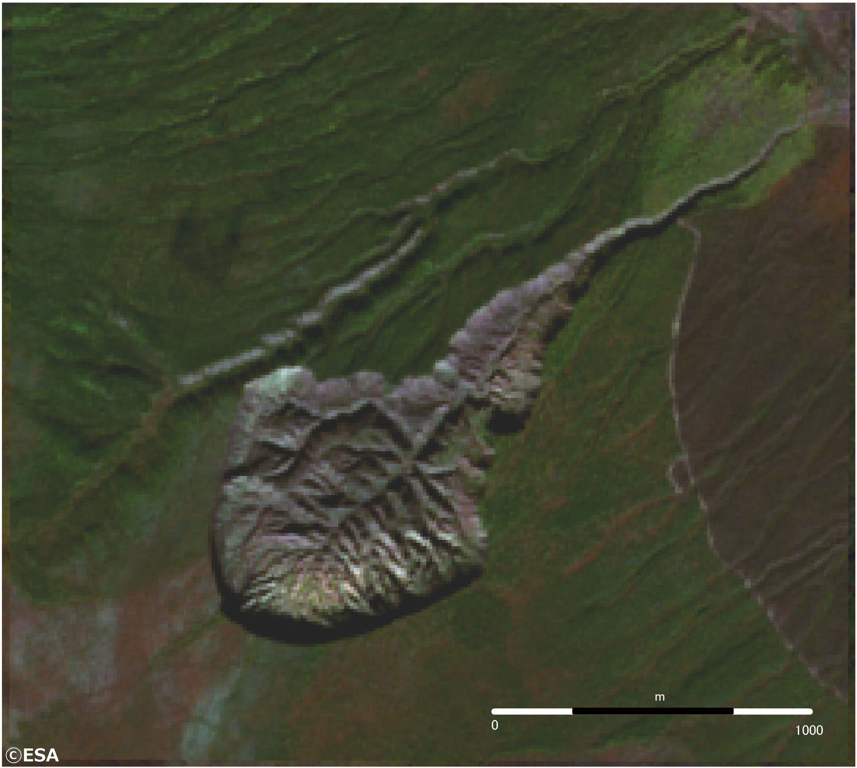
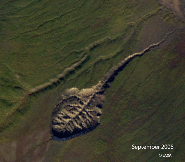
②The appearing crater “Batagaika” in Russia
 |
 |
| Fig.②-1 September 2008 ALOS |
Fig.②-2 September 2021 Sentinel-2 |
Fig.②-1 and Fig.②-2 show the one crater in 2008 and 2021.
This crater is called “Batagaika crater” which is located at Sakha Republic in Eastern Siberia. The crater was appeared because of thawing permafrost and land subsidence.
To compare with the satellite images of Fig.②-1 and Fig②-2, you can see the expansion of the crater. The sizes of holes are estimated about 0.6km2 and 0.9km2 in 2008 and 2021 respectively and it got spread about 1.5 times bigger. The depth is up to 90 m. It keeps expanding even now. This Batagaika crater is one of the largest craters formed by thawing permafrost.
Permafrost is permanently frozen soil which contains organic carbon deposits and is found in the high latitudes of the Arctic region. It is considered thawing permafrost has accelerated since 1960 for main two reasons. The first reason is deforestation due to the development. Trees that cover the permafrost have disappeared and the sunlight has warmed the ground surface. The second one is temperature rise due to global warming. It is believed that thawing permafrost will release greenhouse gases such as carbon dioxide and methane that have been accumulated in the soil, promoting a vicious cycle of global warming.
Created by Fig.②-1 and Fig.②-2
The advantage of Earth observation satellites is to enable to monitor a wide range at once. This allows to see the whole picture like Aral Sea and Batagaika Crater which are mentioned in this article. Furthermore, continuous observation makes it possible to see changes over time.
In this article, we picked up the two environmentally changed areas caused by human activities that were so large that they can be captured even from Space. Why don’t we think about what we can do for only our planet on “Earth Day”?
Information of Satellite Images
| About ① | |
| Satellite : | Fig.①-1 Advanced Earth Observing Satellite-Ⅱ “Midori-Ⅱ” (ADEOS-Ⅱ) |
| Sensor : | Global Imager (GLI) |
| Observation Date : | October 14, 2003 |
| Satellite : | Fig.①-2 Advanced Land-Observing Satellite “DAICHI” (ALOS) |
| Sensor : | Advanced Visible and Near Infrared Radiometer-2 (AVNIR-2) |
| Observation Date : | September 23, 2006 – October 30, 2007 (UTC) |
| Ground resolution : | 10m |
| Satellite : | Fig.①-3 Sentinel-2 (ESA) |
| Observation Date : | September 15, 2021 – September 30, 2021 |
| Ground resolution : | 10m |
| About ② | |
| Satellite : | Fig②-1 Advanced Land-Observing Satellite “DAICHI” (ALOS) |
| Sensor : | Advanced Visible and Near Infrared Radiometer-2 (AVNIR-2) |
| Observation Date : | September 10, 2008 (UTC) |
| Ground resolution : | 10m |
| Satellite : | Fig. ②-2 Sentinel-2 (ESA) |
| Observation Date : | September 1, 2021 – September 3, 2021 |
| Ground resolution : | 10m |
Search by Year
Search by Categories


Tags
-
#Earthquake
-
#Land
-
#Satellite Data
-
#Aerosol
-
#Public Health
-
#GCOM-C
-
#Sea
-
#Atmosphere
-
#Ice
-
#Today's Earth
-
#Flood
-
#Water Cycle
-
#AW3D
-
#G-Portal
-
#EarthCARE
-
#Volcano
-
#Agriculture
-
#Himawari
-
#GHG
-
#GPM
-
#GOSAT
-
#Simulation
-
#GCOM-W
-
#Drought
-
#Fire
-
#Forest
-
#Cooperation
-
#Precipitation
-
#Typhoon
-
#DPR
-
#NEXRA
-
#ALOS
-
#GSMaP
-
#Climate Change
-
#Carbon Cycle
-
#API
-
#Humanities Sociology
-
#AMSR
-
#Land Use Land Cover
-
#Environmental issues
-
#Quick Report
-
#GOSAT-GW
Related Resources


Related Tags
Meteorology and the Environment Related Articles
-
 Meteorology and the Environment 2025.11.05 Wed The Breakup of the World’s Largest Iceberg, “A23a”: The Trajectory of Iceberg A23a Observed by “GCOM-W”, “ALOS-2”, “ALOS-4” and the Latest Satellite, “GOSAT-GW”
 -
 Meteorology and the Environment 2025.10.02 Thu Satellite Observations and Flood Forecasts for Line-shaped Rainbands in August 2025
 -
 Meteorology and the Environment 2025.05.20 Tue February 2025: Global Sea Ice Extent Reaches its Lowest in the History of Satellite Observations
 -
 Meteorology and the Environment 2023.10.11 Wed Climate Change 2023 (2) : Antarctic Winter Sea Ice Extent Lowest Ever Recorded
Stay Connected
