


Research and Development
2021.12.22 Wed
Performance improvement in global precipitation data from satellites
JAXA has observed rainfall in the world together with NASA for more than 20 years through Tropical Rainfall Measuring Mission (TRMM) and Global Precipitation Measurement Mission (GPM). Also, by using multiple satellite observation data from TRMM, GPM and the Global Change Observation Mission – Water “SHIZUKU” (GCOM-W), JAXA provides the Global Satellite Mapping of Precipitation (GSMaP) which is applicable in various fields including disaster prevention not limited to weather.
In order to provide more user friendly and high-accuracy precipitation data, JAXA has continuously conducted the researches for improving rainfall estimation algorithm in cooperation with universities and research institutions. We are pleased to announce that following data versions have been upgraded since December 2021.
■The Global Satellite Mapping of Precipitation (GSMaP) data
GSMaP provides an hourly global precipitation distribution data by satellites. Accumulated precipitation information for more than 20 years which is useful for agriculture field and climate monitoring, and real-time precipitation data which is useful for monitoring of typhoon and cyclone are available.
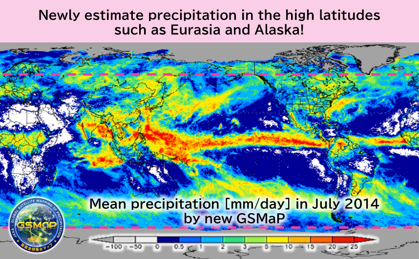
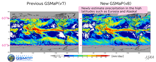
So far, GSMaP has not provided precipitation information in the polar regions above 60 degrees north and south latitude, because it was developed based on the GPM core observatory (observation range: from 65 degrees north to 65 degrees south latitude). However, new GSMaP released in this month extended its observation range to the polar regions by making effective use of satellite microwave radiometer observations at high latitudes where the GPM core observatory cannot observe. This improvement makes it newly possible to estimate precipitation in the high latitudes of Eurasia and Alaska. In the comparison of monthly mean precipitation in July 2014 between previous GSMaP and new GSMaP shown in Figure 1, we can see that the area where precipitation can be estimated has been extended. The rainfall estimation algorithm updated in December 2021 includes various improvement and we have confirmed the modification such as accuracy improvement(for more details, please refer to the documents here). Note that regions covered with sea-ice and Greenland are missing in this new version because these regions are still under study. Also, rainfall estimation in time slot when microwave radiometers do not pass through is a challenge for the future. JAXA plans to continue research development toward further performance upgrade of GSMaP.
■Data from the Dual-frequency Precipitation Radar onboard the GPM core observatory
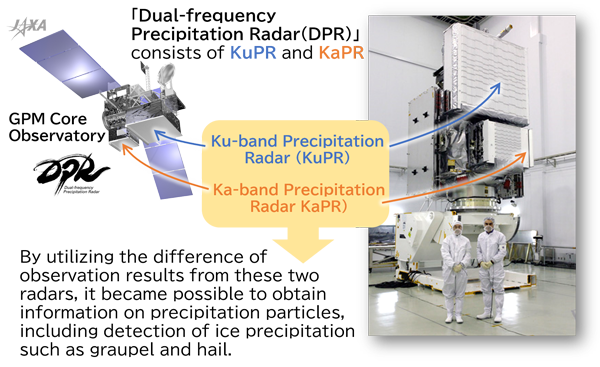
A satellite sensor that is important for the development of GSMaP is the Dual-frequency Precipitation Radar (DPR) onboard the GPM core observatory. DPR is the only instrument in operation which can measure rain in three dimensions with high accuracy from space. By using three-dimensional observations of precipitation, we can promote better understanding of characteristics of rainfall and contribute to the improvement of numerical weather models to forecast rainfall. The observation data of DPR has operationally utilized for numerical weather prediction of Japan Meteorological Agency since March 2016 and the data plays a useful role in daily weather forecast.
The GPM core observatory was launched from JAXA Tanegashima Space Center in February 2014. The satellite far exceeded its design life of three years and two months and has continued its operation for more than 7 years. As its name “Dual-frequency” suggests, DPR observes rainfalls by using two frequencies. As shown in Figure 2, it consists of a Ku-band precipitation radar and a Ka-band precipitation radar. By utilizing the difference of observation results from these two radars, it became possible to obtain information on precipitation particles, including detection of ice precipitation such as graupel and hail.
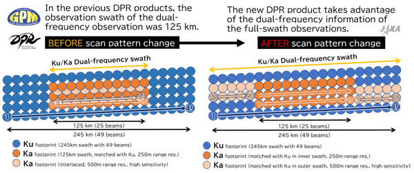
JAXA and NASA changed the scan pattern of Ka-band precipitation radar (KaPR) as shown in Figure 3 on May 21, 2018, after transition to latter phase in operation. Before this scan pattern change, dual-frequency information by Ku- and Ka-band radars could observe precipitation only in a narrow inner swath of 125 km, whereas dual-frequency observation information can be applied in full swath of 245 km after the pattern change. By applying the algorithm corresponding to the scan pattern change, new GPM/DPR product can obtain dual-frequency information in full swath of 245 km. Therefore, we can expect further research progress (for more details, please refer to the documents here).
As for DPR Spectral Latent Heating (SLH) product, in addition to the improvement of algorithms for tropics and for mid-latitudes, we have developed the estimation approach in highland and slope area which had been missing so far and introduced them from new version.
These generally provided GPM product can be obtained from JAXA G-Portal. As for GSMaP, data in different formats (Binary/CSV/NetCDF) from G-Portal (HDF/TXT) can be obtained from JAXA Global Rainfall Watch. Please feel free to use the sites.
Related Sites
JAXA Global Rainfall Watch (GSMaP data)
JAXA 3D Rainfall Watch (GPM/DPR data)
Search by Year
Search by Categories


Tags
-
#Earthquake
-
#Land
-
#Satellite Data
-
#Aerosol
-
#Public Health
-
#GCOM-C
-
#Sea
-
#Atmosphere
-
#Ice
-
#Today's Earth
-
#Flood
-
#Water Cycle
-
#AW3D
-
#G-Portal
-
#EarthCARE
-
#Volcano
-
#Agriculture
-
#Himawari
-
#GHG
-
#GPM
-
#GOSAT
-
#Simulation
-
#GCOM-W
-
#Drought
-
#Fire
-
#Forest
-
#Cooperation
-
#Precipitation
-
#Typhoon
-
#DPR
-
#NEXRA
-
#ALOS
-
#GSMaP
-
#Climate Change
-
#Carbon Cycle
-
#API
-
#Humanities Sociology
-
#AMSR
-
#Land Use Land Cover
-
#Environmental issues
-
#Quick Report
-
#GOSAT-GW
Related Resources


Related Tags
Research and Development Related Articles
-
 Research and Development 2026.03.09 Mon High-Resolution Predictions of Global Terrestrial Water Cycle:
Today’s Earth – Global Updated -
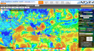 Research and Development 2025.06.18 Wed Advancing Space-Based Weather Analysis and Forecasting – Renewal of JAXA’s Realtime Weather Watch ‘NEXRA3’ and Performance Evaluation with the previous system (Overview Article)
 -
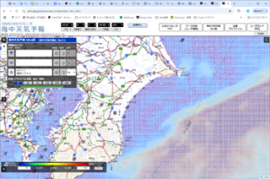 Research and Development 2025.03.27 Thu Launch of Ocean Weather Forecasts 1km resolution
 -
 Research and Development 2024.05.27 Mon The Use of Earth Observation Satellite Data in the Humanities and Social Sciences (3)
Stay Connected
