


Research and Development
2021.08.02 Mon
Recent decadal enhancement of Meiyu-Baiu heavy rainfall, which is revealed by long-term satellite observations (overview article)
Under the effect of global warming and climate change, heavy rainfalls have occurred almost every year during the Meiyu-Baiu season in recent years, causing frequent water-related disasters. Also, in this year, heavy rainfalls with the Meiyu-Baiu front which became active in early July caused landslide disaster in Tokai and southern Kanto region including Atami. For the purpose of more accurate rainfall prediction, it is highly important to capture how rainfall patterns have changed in recent years.
JAXA has observed rainfall all over the world from space by using Tropical Rainfall Measuring Mission (TRMM) and Global Precipitation Measurement Mission (GPM) for more than 20 years. As a research using these long-term precipitation radar data from satellites, the findings of Tokyo Metropolitan University and Nagoya University was published on electronic edition of “Scientific Reports” by Nature Research on July 7 (British Time). According to the press release about this research publication from Tokyo Metropolitan University, the results of this study suggest the change in rainfall pattern of the Meiyu-Baiu front. Continuous monitoring by the precipitation observation satellites is important. In addition, it is necessary to adapt disaster-prevention measures corresponding with the change in rainfall pattern. This work was conducted under the support of JAXA joint research (2nd Research Announcement on the Earth Observations; EO-RA2). Therefore, in addition to the latest study result of Tokyo Metropolitan University and Nagoya University, this article will introduce precipitation observations by radars onboard JAXA satellites.
●Information on research paper
Title: Recent decadal enhancement of Meiyu-Baiu heavy rainfall over East Asia
Authors: Hiroshi G. Takahashi (Department of Geography, Tokyo Metropolitan University), Hatsuki Fujinami (Institute for Space–Earth Environmental Research, Nagoya University)
DOI: 10.1038/s41598-021-93006-0
●News release from the EurekAlert
New long-term satellite analysis shows “plum” rainy season wetter now than ever before
Recent decadal enhancement of Meiyu-Baiu heavy rainfall
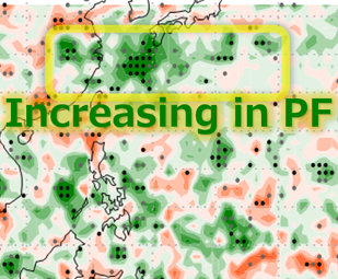
As a result of analysis using long-term satellite precipitation radar data from TRMM and GPM for more than past 20 years, Figure 1 shows the distribution of differences in precipitation frequency for each 11-year average from 1998–2008 and 2009–2019. In the area around the southern part of Kyushu where the Meiyu–Baiu front is stagnant, we can see the increase of precipitation frequency shown in green. This result means that precipitation activity in the Meiyu–Baiu front in recent 11 years (2009–2019) has been more active than in previous 11 years (1998–2008).
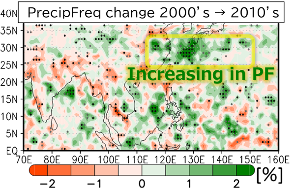
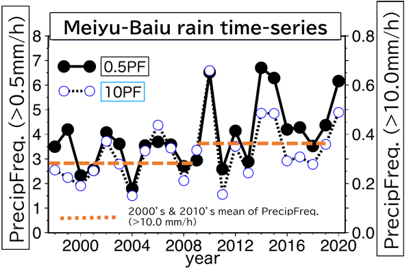
Figure 2 shows time-series of precipitation frequency from 1998 to 2020. We can see annual variation and confirm that the average precipitation frequency for 2009–2019 has increased compared with the period 1998–2008. An increase in the level of precipitation activity has possibility of leading severe weather disaster. The frequency of heavy precipitation with more than 10 mm/h in 2009-2019 is approximately 25% higher than that in 1998-2008, indicating that precipitation activity has been enhanced.
In addition, this study shows analysis result of atmospheric circulations in the Meiyu–Baiu season over the recent two decades to understand what kind of atmospheric circulation changes bring the enhancement of the Meiyu–Baiu front. It is reported that there was a trend to increase transport of water vapor along with the eastern edge of Pacific high and a trend to enhance the pressure trough which strengthen the upward flow on the west side of the Meiyu–Baiu front in the upper-troposphere (around 12,000 m above the ground).
Precipitation observation from space for more than 20 years which contributed to the study result
In this study, satellite precipitation observation data from TRMM and GPM are utilized. One of the important points of this study is that there are only few analyses to examine long-term change of the Meiyu–Baiu front activity by actual measurement data although numerical simulations have been conducted. Rainfall over land can be observed by rain gauge and weather radar on the ground, however it is difficult to observe rainfall quantitatively over the oceans in the same way as on land. So, observation from satellites is important information source. Also, in order to understand long-term change of rainfall, homogeneous data is necessary for a long period.
The TRMM satellite was launched from JAXA Tanegashima Space Center in November, 1997. The Precipitation Radar (PR) developeddeveloped by Japan is deployed on the TRMM satellite and it is the world’s first satellite sensor which can capture three-dimensional structure of tropical rainfall from space. The TRMM satellite far exceeded its design life of three years and two months and continued observations for 17 years to contribute to research on the study of precipitation. The GPM core observatory, which is the successor and development mission of the TRMM satellite was launched from JAXA Tanegashima Space Center in February, 2014. The target of TRMM was tropical rainfall (from 35N to 35S latitude), but GPM extended its observation coverage to middle latitude (from 65N to 65S latitude). The GPM core observatory is equipped with the Dual-frequency Precipitation Radar (DPR) as a Japan’s advanced precipitation radar and the DPR observes three-dimensional structure of rain and snow in the world. Same as the TRMM satellite, the design life of the GPM core observatory is three years and two months. Since the launch in 2014, the GPM core observatory has continued its operation for more than 7 years and conducted rainfall observation from space.
JAXA has been working for accuracy improvement of long-term observation data by calibration work and development of long-term precipitation products using rainfall estimation algorithms which are commonly applicable to TRMM and GPM. As a result, combination use of data from TRMM and GPM makes it possible to analyze precipitation activity for the past 23 years with almost same quality covering both land and sea. The data is used in the research introduced in this article. The realization of long-term satellite precipitation observation following TRMM to GPM leads to study results introduced here.
Toward continuous precipitation observations from satellites in the future
The observation data of GPM has operationally utilized for numerical weather prediction of Japan Meteorological Agency since March 2016 and the data plays a useful role in daily weather forecast. As seen in the study result, accurate and homogeneous long-term satellite precipitation radar plays an important role to get an insight regarding precipitation feature, which is also essential in aspects of disaster prevention. In order to prepare for frequent and tremendous water-related disasters, further long-term use of satellite precipitation data is required. Also, the latest “Basic Plan on Space Policy” of the Cabinet Office includes the approach such as “continuously upgrading core satellite technologies, such as radar and microwave radiometer technologies”. In addition to continuous operation of the GPM core observatory, JAXA is considering next mission as a successor of the precipitation radar and will continue to contribute further understanding of precipitation feature.
Related Sites
Search by Year
Search by Categories


Tags
-
#Earthquake
-
#Land
-
#Satellite Data
-
#Aerosol
-
#Public Health
-
#GCOM-C
-
#Sea
-
#Atmosphere
-
#Ice
-
#Today's Earth
-
#Flood
-
#Water Cycle
-
#AW3D
-
#G-Portal
-
#EarthCARE
-
#Volcano
-
#Agriculture
-
#Himawari
-
#GHG
-
#GPM
-
#GOSAT
-
#Simulation
-
#GCOM-W
-
#Drought
-
#Fire
-
#Forest
-
#Cooperation
-
#Precipitation
-
#Typhoon
-
#DPR
-
#NEXRA
-
#ALOS
-
#GSMaP
-
#Climate Change
-
#Carbon Cycle
-
#API
-
#Humanities Sociology
-
#AMSR
-
#Land Use Land Cover
-
#Environmental issues
-
#Quick Report
-
#GOSAT-GW
Related Resources


Related Tags
Research and Development Related Articles
-
 Research and Development 2026.03.09 Mon High-Resolution Predictions of Global Terrestrial Water Cycle:
Today’s Earth – Global Updated -
 Research and Development 2025.06.18 Wed Advancing Space-Based Weather Analysis and Forecasting – Renewal of JAXA’s Realtime Weather Watch ‘NEXRA3’ and Performance Evaluation with the previous system (Overview Article)
 -
 Research and Development 2025.03.27 Thu Launch of Ocean Weather Forecasts 1km resolution
 -
 Research and Development 2024.05.27 Mon The Use of Earth Observation Satellite Data in the Humanities and Social Sciences (3)
Stay Connected
