


Latest Observation
2018.10.25 Thu
Autumn-colored leaves captured by GCOM-C
Earth observation by GCOM-C, which was launched from the Tanegashima Space Center in 2017, is on track. Let us introduce the autumn-colored leaves and defoliated trees captured by GCOM-C in Japan.
GCOM-C has multiple channels in the visible range with a 250-m resolution and observes the Earth’s surface approximately once every two days. We previously reported that GCOM-C captured the spring leaf expansion in the forest and would be happy to report that it also captured autumn-colored leaves and defoliated trees.
Look at Figure 1, an RGB color image of Japan from Hokkaido to the Kinki region, observed by the Second-generation Global Imager (SGLI) onboard GCOM-C in October 2018. The white areas are clouds and snow-covered areas.
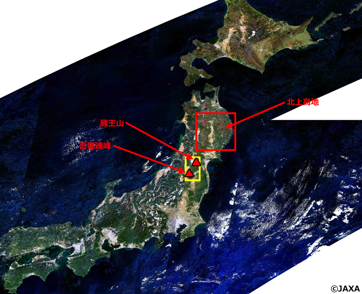
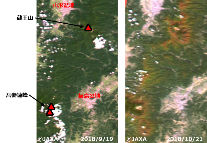
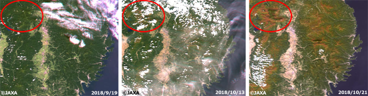
Look at Figure 2, an RGB color image that extended the yellow-squared area in Figure 1. In the forests, leaves looked green, while autumn-colored leaves and defoliated trees looked brown. We could find the progress of autumn coloring and falling leaves in a month in the mountainous area from Mt. Zao to the Azuma Mountains. Now look at Figure 3, an RGB color image that extended the red-squared area in Figure 1 in Akita and Iwate prefectures observed on September 19, October 13, and October 21. We could find that the leaves are turning red and falling around Mt. Hachimantai, Mt. Iwate, and Mt. Komagatake (see the red circles in Figure 3) and the Kitakami Highlands.
GCOM-C observes forests and land surfaces on a global scale with high frequency. Figure 1 is an image generated from SGLI’s atmospheric corrected surface reflectance data, which is corrected for the effects of light scattering and absorption by gas molecules and aerosol particles in the air. JAXA will release the atmospheric corrected surface reflectance data and vegetation index data corresponding to vegetation density in December 2018.
Explanation of the Images
Figs. 1-3
| Satellite | Global Change Observation Mission-Climate “SHIKISAI” (GCOM-C) |
|---|---|
| Sensor | Second-generation Global Imager (SGLI) |
| Date | October 2018 (Fig. 1). September 19, 2018 and October 21, 2018 (Fig. 2) September 19, 2018, October 13, 2018, and October 21, 2018 (Fig. 3) |
Related Sites
Search by Year
Search by Categories


Tags
-
#Earthquake
-
#Land
-
#Satellite Data
-
#Aerosol
-
#Public Health
-
#GCOM-C
-
#Sea
-
#Atmosphere
-
#Ice
-
#Today's Earth
-
#Flood
-
#Water Cycle
-
#AW3D
-
#G-Portal
-
#EarthCARE
-
#Volcano
-
#Agriculture
-
#Himawari
-
#GHG
-
#GPM
-
#GOSAT
-
#Simulation
-
#GCOM-W
-
#Drought
-
#Fire
-
#Forest
-
#Cooperation
-
#Precipitation
-
#Typhoon
-
#DPR
-
#NEXRA
-
#ALOS
-
#GSMaP
-
#Climate Change
-
#Carbon Cycle
-
#API
-
#Humanities Sociology
-
#AMSR
-
#Land Use Land Cover
-
#Environmental issues
-
#Quick Report
-
#GOSAT-GW
Related Resources


Latest Observation Related Articles
-
 Latest Observation 2026.06.05 Fri [Quick Report] Typhoon No. 6, “JANGMI”, brought heavy rain to Japan. – Results of satellite data analysis –
 -
 Latest Observation 2026.04.16 Thu [Quick Report] EarthCARE Captured the Eye of Typhoon Sinlaku
 -
 Latest Observation 2025.12.03 Wed [Quick Report] Analysis results from satellite precipitation data on the record-breaking heavy rainfall occurring in Southeast Asia in late November 2025
 -
 Latest Observation 2025.10.01 Wed [Quick Report] Hurricane Humberto “Eye” captured by EarthCARE satellite (Hakuryu)
Stay Connected
