


Research and Development
2015.11.02 Mon
Release of the JAXA Realtime Rainfall Watch
Earth Observation Research Center (EORC) of Japan Aerospace Exploration Agency (JAXA) has developed GSMaP* realtime version (GSMaP_NOW) providing current rainfall information over the JMA’s geostationary satellite “Himawari” observation area, and released those information through a new webpage “JAXA Realtime Rainfall Watch” (Figure 1).
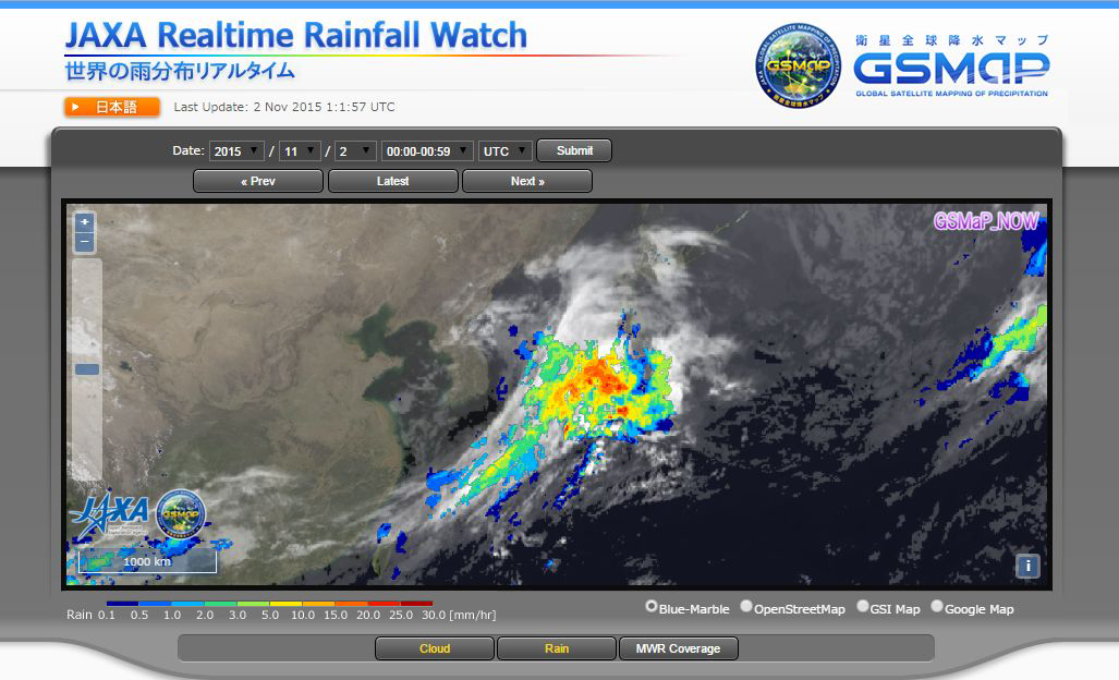
Figure 1. Example image of the web site “JAXA Realtime Rainfall Watch”.
GSMaP (Global Satellite Mapping of Precipitation) is a satellite-based global rainfall map that combines rainfall estimates by multi microwave radiometers and estimates of movement of rainy areas by geostationary satellites’ Infrared imagers. JAXA has provided images and data of the GSMaP near-real-time version 4-hour after observation through the web site “JAXA Global Rainfall Watch”. GSMaP is also one of the JAXA standard products of the Global Precipitation Measurement (GPM) mission since September 2014.
GSMaP near-real-time version (GSMaP_NRT) spends 3-hour for satellite data collection and 1-hour for data processing, so it enables to provide data 4-hour after observation. This processing scheme was set as trade-off between collection of more observation data to assure data accuracy and shorter data latency to expand data utilization capability. However, as number of the GSMaP_NRT user increases, it is about 1,600 registered users as of September 2015, and application fields of GSMaP_NRT expands, there are more requests from meteorological agencies in Asian countries and flood alert communities to shorten data latency of GSMaP_NRT.
To response these requests, we developed GSMaP_NOW product, which estimate “quasi-realtime” rainfall information, by shortening data collection period to half-hour and extrapolating rainfall map half-hour toward future direction by using cloud moving vector from IR imager of the geostationary satellite. Since we can only use data that is available within half-hour, input data is GPM/GMI, GCOM-W/AMSR2 direct receiving data, NOAA and MetOp’s AMSU direct receiving data, and IR imager data onboard the geostationary satellite “Himawari-8”. GSMaP_NOW provides hourly rainfall in 0.1 degree grid and updated half-hourly. For example, hourly GSMaP_NOW image and data during 0930Z and 1029Z is available at around 1030Z through the web site.
Since GSMaP_NOW uses less passive microwave radiometer data as input compared to that of GSMaP_NRT, its data accuracy tends to be worse qualitatively. Verification of GSMaP_NOW with JMA’s gauge-calibrated radar analysis (Radar-AMeDAS) in daily and 0.25-degree grid basis shows result that RMSE and correlation coefficient are 0.20 mm/h and 0.59, respectively, for the period from October 3 to 20, 2015. For the same period, those of GSMaP_NRT are 0.19 mm/h and 0.65, and accuracy of GSMaP_NOW is almost comparable to or slightly less than that of GSMaP_NRT.
This quasi-realtime capability will provide possibility to operational users to apply the GSMaP_NOW data in their rainfall monitoring more rapidly, flood alert in smaller river basins lead time from raining to flood is shorter. Extension of GSMaP_NOW from “Himawari” area to the other geostationary satellites’ observation areas is also under consideration for future improvements.
Explanation of the Images
(Fig.1)
| Satellite | Global Precipitation Measurement (GPM) Core Observatory Global Change Observation Mission – Water “SHIZUKU” (GCOM-W) MetOP Satellite series NOAA Satellite series Himawari-8 |
|---|---|
| Sensor | GPM Microwave Imager(GMI) Advanced Microwave Scanning Radiometer 2(AMSR2) Advanced Microwave Sounding Unit/Microwave Humidity Sounder(AMSU/MHS) Advanced Microwave Sounding Unit/Microwave Humidity Sounder(AMSU/MHS) Advanced Himawari Imager(AHI) |
| Date | 09:00-09:59JST on Nov. 02, 2015 00:00-00:59UTC on Nov. 02, 2015 |
Related Sites
Search by Year
Search by Categories


Tags
-
#Earthquake
-
#Land
-
#Satellite Data
-
#Aerosol
-
#Public Health
-
#GCOM-C
-
#Sea
-
#Atmosphere
-
#Ice
-
#Today's Earth
-
#Flood
-
#Water Cycle
-
#AW3D
-
#G-Portal
-
#EarthCARE
-
#Volcano
-
#Agriculture
-
#Himawari
-
#GHG
-
#GPM
-
#GOSAT
-
#Simulation
-
#GCOM-W
-
#Drought
-
#Fire
-
#Forest
-
#Cooperation
-
#Precipitation
-
#Typhoon
-
#DPR
-
#NEXRA
-
#ALOS
-
#GSMaP
-
#Climate Change
-
#Carbon Cycle
-
#API
-
#Humanities Sociology
-
#AMSR
-
#Land Use Land Cover
-
#Environmental issues
-
#Quick Report
-
#GOSAT-GW
Related Resources


Related Tags
Research and Development Related Articles
-
 Research and Development 2026.03.09 Mon High-Resolution Predictions of Global Terrestrial Water Cycle:
Today’s Earth – Global Updated -
 Research and Development 2025.06.18 Wed Advancing Space-Based Weather Analysis and Forecasting – Renewal of JAXA’s Realtime Weather Watch ‘NEXRA3’ and Performance Evaluation with the previous system (Overview Article)
 -
 Research and Development 2025.03.27 Thu Launch of Ocean Weather Forecasts 1km resolution
 -
 Research and Development 2024.05.27 Mon The Use of Earth Observation Satellite Data in the Humanities and Social Sciences (3)
Stay Connected
