
Meteorology and the Environment
2014.02.27 Thu
Air pollutants across borders observed from space
During the period from January to early February, 2013, the air pollutant (Note 1) PM2.5 was transported across borders on the Asian continent, and a high concentration exceeding the environmental standard value (daily mean 35 μg/m3) was observed around western Japan. Media reports from Japan provided photographs of hazy air and pedestrians wearing masks around the city of Beijing, China. These reports received a great deal of public attention because air pollution poses such a high risk to the health of respiratory and circulatory organs. Japan is located east of the Eurasian continent and downwind of the prevailing westerlies. As a result, yellow sand from Eurasian deserts, and aerosols (suspended particulate matter(SPM) and particulate matter(PM)) (Note 2) emitted from the burning of fossil and biomass fuels, are transported to Japan from the continent by the wind. Observations and air-quality forecasts are provided to the public to increase their awareness of any public health concerns that could affect outdoor activities, such as drying laundry in the open air. On February 21, 2013, the Ministry of the Environment (MOE) issued a press release regarding the results of an analysis of the observation data and a simulation of the high concentration of PM2.5, which exceeded the environmental standard value from January to early February, 2013, in the wide-ranging area around western Japan(Ref.1). The following remarks reflect the report of the meeting on PM2.5 held by the MOE(Ref.2):
-
A high concentration of PM2.5 that exceeded the environmental standard value was observed in western Japan. The concentration in January, 2013 did not exceed the value significantly in comparison with the prior two-year record nationwide.
-
It was concluded that the increase in concentration was due to the effects of air pollution from the Eurasian continent.
-
In the region of Tokai and northern Kanto, observations were made of a high concentration of PM2.5 combined with cross-border pollutants in urban areas.
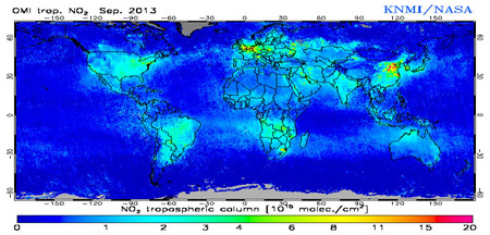
On several occasions after late September of 2013, the concentration of PM2.5 was significantly higher than the environmental standard pollution level. As shown in Fig. 1, air pollution in the troposphere was visualized by the NASA Ozone Monitoring Instrument (OMI) (Ref. 3), and it was displayed on a global distribution map of the nitrogen dioxide (NO2) total column density monthly average for September of that year. As can be seen on the map, a high concentration area was observed around Beijing.
Fig. 1. Global Map of Tropospheric Column Density of Nitrogen Dioxide observed by Ozone Monitoring Instrument (OMI), space-borne sensor of NASA (Unit: 1015molecule/cm2).
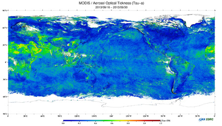
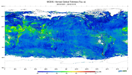
The two images presented in Fig. 2 are MODIS images of Aerosol Optical Thickness (observed during September 16–30 and October 1–15, 2013). These aerosols are composed of yellow sand, suspended particulate matter, and particulate matter emitted from the burning of fossil and biomass fuels. There are several ways in which aerosols are reduced in the air. For example, water vapor can cover the core of the aerosol particle, forming a water droplet that falls to the ground in the form of rain. In addition, heavier particles will drop after traveling a shorter distance, depending on the effect of gravity and on the weight of the particles. The lifetime of PM2.5 floating in the air is several hours or days in the lower atmosphere, and several days or months in the upper atmosphere. In some cases, they can travel approximately half the distance around the circumference of the Earth.
Fig. 2. Global map of Aerosol Optical Thickness distribution observed by MODIS.
Top image: Observed on September 16–30, 2013.
Bottom image: Observed on October 1–15, 2013
Therefore, in order to reduce PM2.5, worldwide cooperation is necessary on multiple levels, including local, urban, continental, and hemispherical. It is highly important to encourage international cooperation using interoperable ground-based observation networks and satellite remote sensing data. In addition, it takes several years to produce significant information from one satellite through the averaging process of statistical data from a certain period, selecting cloud-free pixels from observed images. Therefore, interoperability is crucial for improving the capability of observed data and responding via rapid information processing. For the integrated use of ground-based observation networks, satellite remote sensing and simulation, JAXA is planning a GOSAT operation continuing from 2009, a GCOM-C launch, and the collaborative mission EarthCARE with ESA in 2016. In addition, MOE, NIES, and JAXA are planning GOSAT-2 in 2017, which is the planned international contribution from Japan.
Note 1: Japan experienced a period of rapid economic growth in the 1960s. During that time, many Japanese citizens suffered from asthma that was caused by environmental pollution (e.g., in Yokkaichi City). Photochemical smog caused by pollutants such as oxidants (oxides such as ozone produced by photochemical reaction on nitrogen oxide, a volatilized organic compound caused by solar radiation), yellow sand, and aerosol particles (suspended particulate matter and particulate matter) was common during that period.
Note 2: An aerosol is a group of solid or liquid particles floating in the atmosphere. The typical components of aerosols are sulfates, nitrates, organic matter, black carbon (soot), minerals (including yellow sand), and sea salt. Most of the particles have a diameter ranging from about 0.3 to 3 μm. PM2.5 is the generic term for suspended particulate matter (SPM) with a diameter less than 2.5 μm. If inhaled, particulates with a diameter of 2.5–10 μm tend to be captured by the nasal cavity and the throat. PM2.5 particulates with a diameter less than 2.5 μm tend to reach deep inside of the lungs, and they can have adverse health effects. Full-scale observation of PM2.5 in Japan began in fiscal year 2010. Prior SPM measurements showed that the concentration in Tokyo and Kawasaki in the 1960s was 200–400 μg/m3, while the SPM annual mean in fiscal year 2011 over Tokyo was 22 μg/m3, indicating an improvement of about one-tenth in comparison with the air pollutant concentration fifty years ago.
Note 3: MOE runs the official website providing PM2.5 information from the air pollutant distribution monitoring system called “Soramame-kun” (in Japanese).
Reference sites
Explanation of the Images:

(Fig. 1)
| Satellite: | EOS-Aura (NASA) |
| Sensor: | Ozone Monitoring Instrument(OMI) |
| Date: | September 2013 |
(Fig. 2)
| Satellite: | Terra, Aqua, NASA |
| Sensor: | Moderate Resolution Imaging Spectroradiometer (MODIS), NASA |
| Date: | Top image: September 16–30, 2013; bottom image: October 1–15, 2013. |
Search by Year
Search by Categories
Tags
-
#Earthquake
-
#Land
-
#Satellite Data
-
#Aerosol
-
#Public Health
-
#GCOM-C
-
#Sea
-
#Atmosphere
-
#Ice
-
#Today's Earth
-
#Flood
-
#Water Cycle
-
#AW3D
-
#G-Portal
-
#EarthCARE
-
#Volcano
-
#Agriculture
-
#Himawari
-
#GHG
-
#GPM
-
#GOSAT
-
#Simulation
-
#GCOM-W
-
#Drought
-
#Fire
-
#Forest
-
#Cooperation
-
#Precipitation
-
#Typhoon
-
#DPR
-
#NEXRA
-
#ALOS
-
#GSMaP
-
#Climate Change
-
#Carbon Cycle
-
#API
-
#Humanities Sociology
-
#AMSR
-
#Land Use Land Cover
-
#Environmental issues
-
#Quick Report
Related Resources
Related Tags
Meteorology and the Environment Related Articles
-
 Meteorology and the Environment 2025.05.20 Tue February 2025: Global Sea Ice Extent Reaches its Lowest in the History of Satellite Observations
 -
 Meteorology and the Environment 2023.10.11 Wed Climate Change 2023 (2) : Antarctic Winter Sea Ice Extent Lowest Ever Recorded
 -
 Meteorology and the Environment 2023.08.31 Thu Climate Change 2023 (1) : Sea Surface Temperature Rise and El Niño Event
 -
 Meteorology and the Environment 2022.04.28 Thu Antarctic Sea Ice Extent Lowest Ever Recorded


