


Latest Observation
2011.02.16 Wed
With the Scent of Japanese Plum: Mito, Japan
caption on
caption off
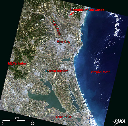
Figure 1 is an image of southern Ibaraki Prefecture in Japan as observed by ALOS (“Daichi”) in February 2010. The coastline on the right-hand side of the figure faces Kashima-nada (“nada” means a rough sea with a rapid current) in the Pacific Ocean. The lake at the bottom is Kasumigaura, the second largest lake in Japan, and a portion of the Tone River is visible below the lake. Ibaraki Airport, opened in March 2010, is visible to the north of Kasumigaura. The area surrounding the airport is a leading agricultural zone and vegetables such as Chinese cabbage, lettuce, burdock, and Japanese pumpkin are the major products of the area. The white area to the north of the airport is Mito, the prefectural capital of Ibaraki.
caption on
caption off
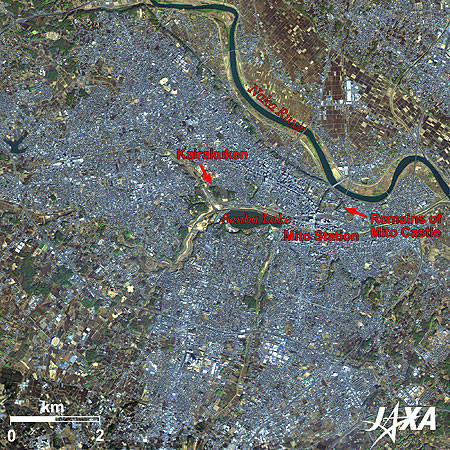
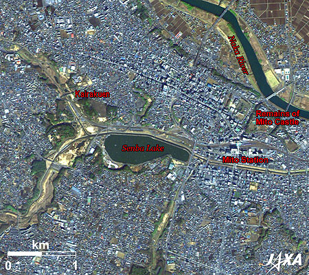
Figure 2 is an enlarged image of the urban area of Mito. Senba Lake, JR (Japan Railways) Mito Station to the right of the lake, and the remains of Mito Castle further to the east are visible near the center of the image. The Naka River flows at the north side of the city. Transportation by water developed there in old times and the name Mito was said to have derived from minato meaning “port” since it grew as a port town.
The remains of Mito Castle are used as educational facilities, such as a high school and so on. The Mito Domain was one of the three major domains of the Tokugawa Shogunate (1603-1868) along with the Owari Domain (Aichi Prefecture) and the Kishuu Domain (Wakayama Prefecture), which held the most prestigious social status. The Mito Domain was in charge of controlling the northeastern domains and was exempt from carrying out the periodical move to Edo (Sankin-kotai), which the local lords were obligated to do to show their loyalty to the Shogunate. In addition, local lords of Mito were granted the privilege to keep permanent residence in Edo.
Throughout the Edo period, Mito developed as a key location of land and waterborne traffic between Edo and the northeastern territories. Mito was one of 31 cities that were first municipalized in 1889. Tokyo, Yokohama, and Mito were such cities in the Kanto area (the Greater Tokyo Area, which encompasses seven prefectures).
Present Mito engages mainly in commerce and service industries and is developing as a commercial town.
caption on
caption off
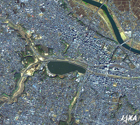
Fig. 3. Enlarged Image of Senba Lake and Its Vicinity
Mito (kmz, 5.14 MB, Low Resolution) as seen on Google Earth.
Senba Lake and Kairakuen: Oases for the Citizens
Senba Lake is seen in the center of the image, and Kairakuen, the renowned garden famous for the Japanese plum, is located north of the lake. There are highlights of other flowers all through the seasons, such as cherries, Kirishima azaleas, bush clovers, and Japanese maples. The garden has 3,000 plum trees of 100 different kinds, and this year the Plum Festival is to be held from February 20 to March 31.
Two Lords of Virtue in the Mito Domain
The second lord of the Mito Domain was Mitsukuni Tokugawa, who is well known as Mito Komon. Mitsukuni made many efforts to build a water supply system and other facilities of infrastructure in the castle town of Mito in order to stabilize the government of the domain. He also invited scholars to assist in the compilation of a history book known as The Great History of Japan. This work continued even after Mitsukuni’s death and was completed in the form of 400-plus-page volumes of history books in 1906. The scholarship formed through this compilation was called Mitogaku (Mito School) and exerted a major influence on the Sonno-Joi movement (the Japanese political slogan to Revere the Emperor, Expel the Barbarians at the end of Edo period) and became one of the driving forces behind the Meiji Restoration.
The ninth local lord, Nariaki Tokugawa, promoted restructuring of the domain, placing emphasis on the coastal guard, public welfare, and education led by scholar Touko Fujita, etc. He also participated in the Shogunate administration, which was in a political ferment by the arrival of Commodore Perry’s fleet. At the Kodokan, built for the members of the Mito Domain, natural sciences such as medicine and astronomy as well as human sciences and social sciences, etc., were widely taught and studied.
Reference Sites:
Explanation of the Images:
| Satellite: | Advanced Land Observing Satellite (ALOS) (Daichi) |
| Sensor: |
Advanced Visible and Near Infrared Radiometer-2 (AVNIR-2) Panchromatic Remote-sensing Instrument for Stereo Mapping (PRISM) |
| Date: | 0133 (UTC) on February 20, 2010 (Simultaneous Observation of AVNIR-2 and PRISM) |
| Ground resolution: | 10 m (AVNIR-2) and 2.5 m (PRISM) |
| Map Projection: | Universal Transversal Mercator (UTM) |
AVNIR-2 has four observation bands. The color composite images are produced by assigning red to Band 3 (610 to 690 nm), green to Band 2 (520 to 600 nm), and blue to Band 1 (420 to 500 nm). The resulting images have natural coloring as if seen by the naked eye. Each color indicates the following ground objects:
| Dark green: | Forests |
| Light green: | Grass fields |
| Brown: | Farmlands or bare land |
| Blue: | Water surface |
| White: | Roads, buildings or clouds |
(Fig. 2 and 3)
PRISM is an optical sensor for observing ground surfaces with visible and near-infrared signals in the 520- to 770-nanometer (one-billionth of a meter) band. The image is monochromatic but has a higher resolution. PRISM has three independent optical systems to acquire images in the view of nadir, forward, and backward simultaneously. Only the nadir images are used in the images.
Related Sites
Transforming an Old Castle Town into an Ordinance Designated City – Okayama, Japan
Kanazawa: The Castle Town of the Old Kaga Domain that Occupied One Million Goku Feudality
Search by Year
Search by Categories


Tags
-
#Earthquake
-
#Land
-
#Satellite Data
-
#Aerosol
-
#Public Health
-
#GCOM-C
-
#Sea
-
#Atmosphere
-
#Ice
-
#Today's Earth
-
#Flood
-
#Water Cycle
-
#AW3D
-
#G-Portal
-
#EarthCARE
-
#Volcano
-
#Agriculture
-
#Himawari
-
#GHG
-
#GPM
-
#GOSAT
-
#Simulation
-
#GCOM-W
-
#Drought
-
#Fire
-
#Forest
-
#Cooperation
-
#Precipitation
-
#Typhoon
-
#DPR
-
#NEXRA
-
#ALOS
-
#GSMaP
-
#Climate Change
-
#Carbon Cycle
-
#API
-
#Humanities Sociology
-
#AMSR
-
#Land Use Land Cover
-
#Environmental issues
-
#Quick Report
-
#GOSAT-GW
Related Resources


Related Tags
Latest Observation Related Articles
-
 Latest Observation 2026.06.05 Fri [Quick Report] Typhoon No. 6, “JANGMI”, brought heavy rain to Japan. – Results of satellite data analysis –
 -
 Latest Observation 2026.04.16 Thu [Quick Report] EarthCARE Captured the Eye of Typhoon Sinlaku
 -
 Latest Observation 2025.12.03 Wed [Quick Report] Analysis results from satellite precipitation data on the record-breaking heavy rainfall occurring in Southeast Asia in late November 2025
 -
 Latest Observation 2025.10.01 Wed [Quick Report] Hurricane Humberto “Eye” captured by EarthCARE satellite (Hakuryu)
Stay Connected
