


Latest Observation
2010.11.29 Mon
Gran Canaria: A Miniature Continent in the Canary Islands
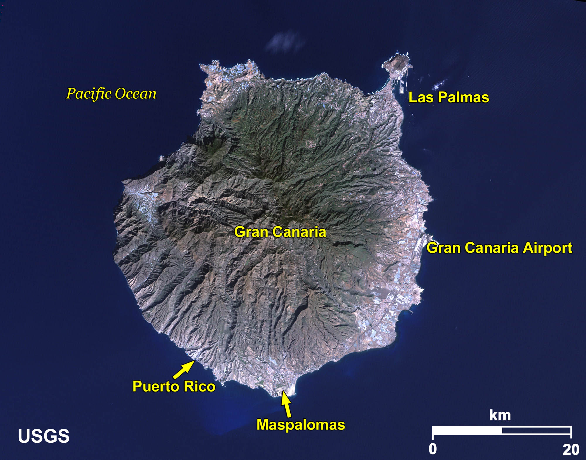
Gran Canaria is one of a group of seven Spanish islands, called the Canary Islands, located in the Atlantic Ocean about 100 kilometers off the coast of Morocco and Western Sahara in northwestern Africa. The island sits at about 28° north latitude, is 200 km around with an area of 1,500 km2, and is of volcanic origin, like the other islands, including Tenerife to the west. Gran Canaria has different climates and a variety of landscapes, and is thus called a “Miniature Continent”.
caption on
caption off
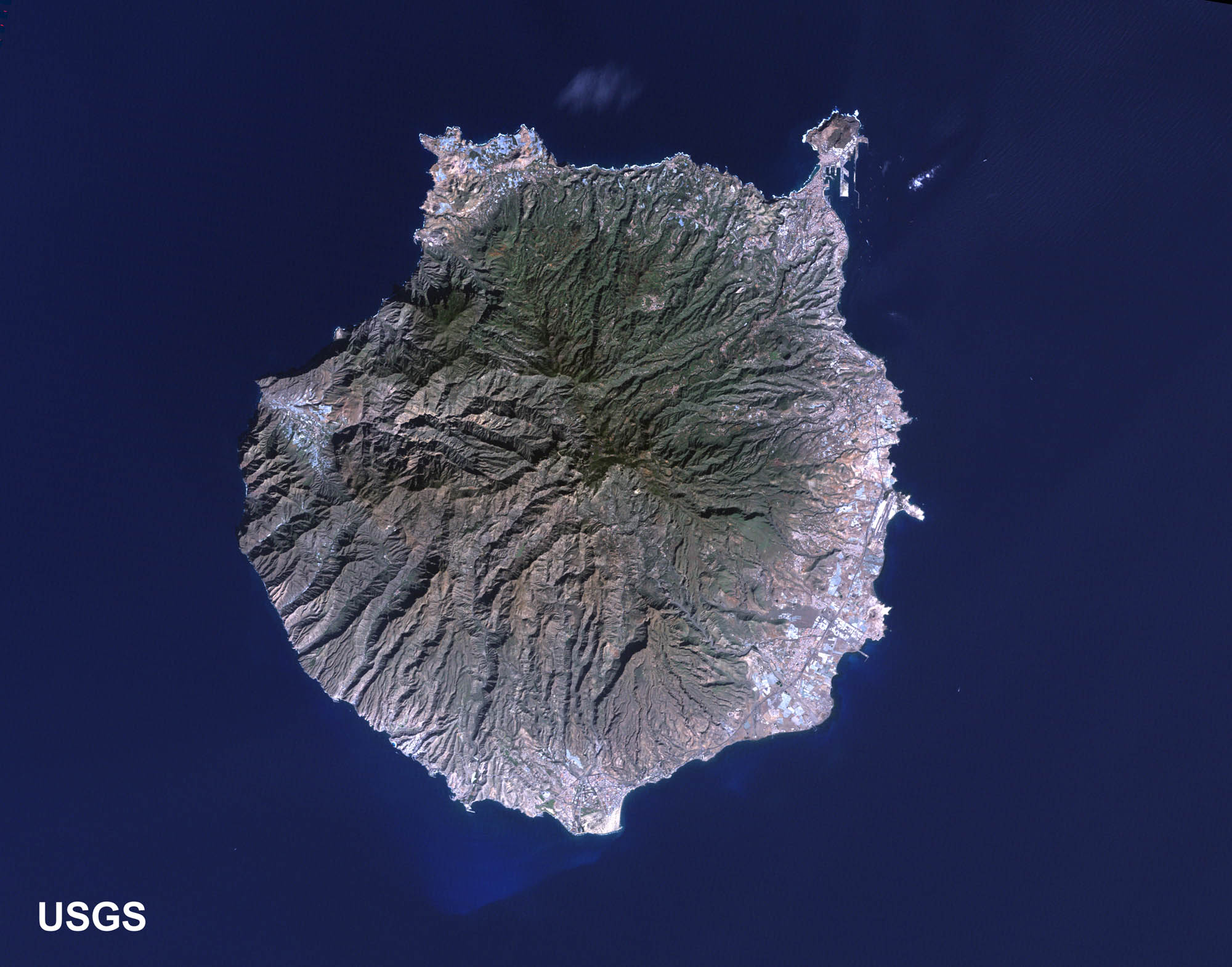
Figure 1 is an image of Gran Canaria as observed by Landsat-5 in January 2010. Las Palmas (Las Palmas de Gran Canaria), located on the northeast of the island, is the capital and most populous city (pop.: 380,000) of the Autonomous Community of the Canary Islands. It shares the function of capital with Santa Cruz of Tenerife in 4-year terms.
The southern part of the island, including Maspalomas, is known as one of the greatest resort areas in Europe, with many resort hotels and sightseeing spots.
caption on
caption off
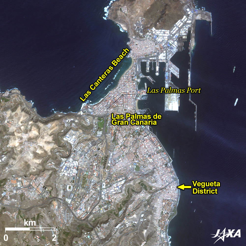
Figure 2 is an enlarged image of Las Palmas as observed by ALOS (“Daichi”) in September 2010. The historic district, La Vegueta, in the southern part of the image is an old city retaining traces of the days when it was once the center of the island. The Columbus House Museum (Museo Casa de Colón) and Santa Ana Cathedral are located in this area. The Columbus House Museum displays and exhibits materials related to Christopher Columbus. This was a private house of the governor of Gran Canaria, and was later converted to a museum. Construction of the Cathedral started around 1500 by a Seville architect, interrupted in 1570, and resumed by a famous local sculptor in 1798. The result of which can be seen in the neoclassical facade and late Gothic interior.
Las Palmas port is known as where Christopher Columbus anchored on his first journey to the Americas. Many luxury liners, such as the Queen Elizabeth 2, have made a port call here. It has also been a base port of Japanese ocean tuna boats for many years.
Las Canteras Beach lies on the northwest of the city and stretches about 3 km. The promenade on the beach is crowded throughout the year. A rocky reef is visible along the coast from the figure, the rocks of which were used for buildings in the city.
caption on
caption off
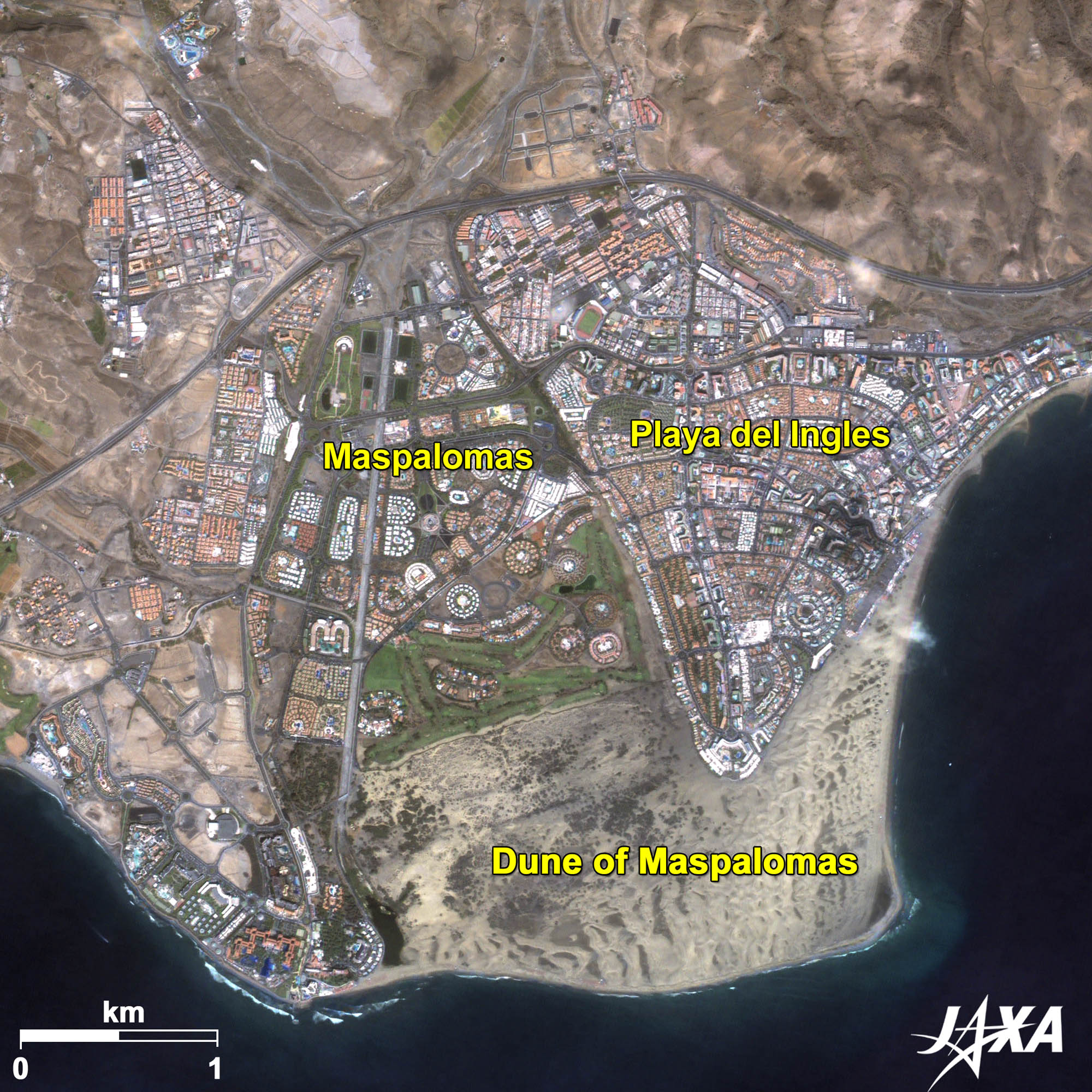
Fig. 3. Geometrically Designed Maspalomas
Maspalomas (kmz, 4.76 MB, Low Resolution) as seen on Google Earth
Figure 3 is an enlarged image of Maspalomas. Playa del Inglés and Puerto Rico, etc., along the south coast are recently developed resort towns. Buildings of funny shapes and golf courses geometrically laid out are visible in the figure. Sand dunes, visible as the grey area, spread south of the city, beyond which are good beaches for swimming. Playa del Inglés, built on the eastern edge of the sand dune, is the largest resort area on the island.
Antenna of JAXA
One of JAXA’s (Japan Aerospace Exploration Agency) tracking and data acquisition antennas is co-located at the satellite ground station of INTA (Instituto Nacional de Técnica Aeroespacial, Spain’s Space Agency) about 4 km west of Maspalomas. This antenna performs tracking and control of Japanese satellites. These overseas antennas as well as those in Japan establish a worldwide satellite-tracking network.
Explanation of the Images:
| Satellite: | Landsat-5 (USA) |
| Sensor: | Thematic Mapper (TM) |
| Date: | January 17, 2010 (UTC) (Fig. 1) |
| Ground resolution: | 30 m |
| Map Projection: | Universal Transversal Mercator (UTM) |
Figure 1 image data was downloaded free of charge from the USGS Global Visualization Viewer (Glovis). The color composite image is produced by assigning red to Band 3 (630 to 690 nm), green to Band 2 (520 to 600 nm), and blue to Band 1 (450 to 520 nm). The resulting image has natural coloring as if seen by the naked eye.
| Satellite: | Advanced Land Observing Satellite (ALOS) (Daichi) |
| Sensor: |
Advanced Visible and Near Infrared Radiometer-2 (AVNIR-2) Panchromatic Remote-sensing Instrument for Stereo Mapping (PRISM) |
| Date: | 0012 (UTC) on September 24, 2010 (AVNIR-2) (Fig. 2 and 3) 2312 (UTC) on November 23, 2009 (PRISM) (Fig. 3) |
| Ground resolution: | 10 m (AVNIR-2) and 2.5 m (PRISM) |
| Map Projection: | Universal Transversal Mercator (UTM) |
AVNIR-2 has four observation bands. The color composite images (Fig. 2 and 3) are produced by assigning red to Band 3 (610 to 690 nm), green to Band 2 (520 to 600 nm), and blue to Band 1 (420 to 500 nm). The resulting images have natural coloring as if seen by the naked eye. Each color indicates the following ground objects:
| Dark green: | Woods |
| Light green: | Grass fields |
| Brown: | Bare land |
| Bluish-grey: | Urban areas |
| Blue: | Sea surface |
| White: | Roads, buildings, or clouds |
| Grey: | Sand dune |
PRISM is an optical sensor for observing ground surfaces with visible and near-infrared signals in the 520- to 770-nanometer (one-billionth of a meter) band. The image is monochromatic but has a higher resolution. PRISM has three independent optical systems to acquire images in the
The above AVNIR-2 color composite image is decomposed into, hue, saturation, and intensity. The intensity portion is replaced by PRISM data. The hue, saturation, and intensity data are then reversed into a color image. This color image has a virtual 2.5-m resolution. A color image (Fig. 3) composed by combining a higher resolution monochromatic image and a lower resolution color image is called a pan-sharpened image.
Search by Year
Search by Categories


Tags
-
#Earthquake
-
#Land
-
#Satellite Data
-
#Aerosol
-
#Public Health
-
#GCOM-C
-
#Sea
-
#Atmosphere
-
#Ice
-
#Today's Earth
-
#Flood
-
#Water Cycle
-
#AW3D
-
#G-Portal
-
#EarthCARE
-
#Volcano
-
#Agriculture
-
#Himawari
-
#GHG
-
#GPM
-
#GOSAT
-
#Simulation
-
#GCOM-W
-
#Drought
-
#Fire
-
#Forest
-
#Cooperation
-
#Precipitation
-
#Typhoon
-
#DPR
-
#NEXRA
-
#ALOS
-
#GSMaP
-
#Climate Change
-
#Carbon Cycle
-
#API
-
#Humanities Sociology
-
#AMSR
-
#Land Use Land Cover
-
#Environmental issues
-
#Quick Report
-
#GOSAT-GW
Related Resources


Related Tags
Latest Observation Related Articles
-
 Latest Observation 2026.06.05 Fri [Quick Report] Typhoon No. 6, “JANGMI”, brought heavy rain to Japan. – Results of satellite data analysis –
 -
 Latest Observation 2026.04.16 Thu [Quick Report] EarthCARE Captured the Eye of Typhoon Sinlaku
 -
 Latest Observation 2025.12.03 Wed [Quick Report] Analysis results from satellite precipitation data on the record-breaking heavy rainfall occurring in Southeast Asia in late November 2025
 -
 Latest Observation 2025.10.01 Wed [Quick Report] Hurricane Humberto “Eye” captured by EarthCARE satellite (Hakuryu)
Stay Connected
