


Latest Observation
2010.10.27 Wed
The Strait of Magellan
Caption on
Caption off
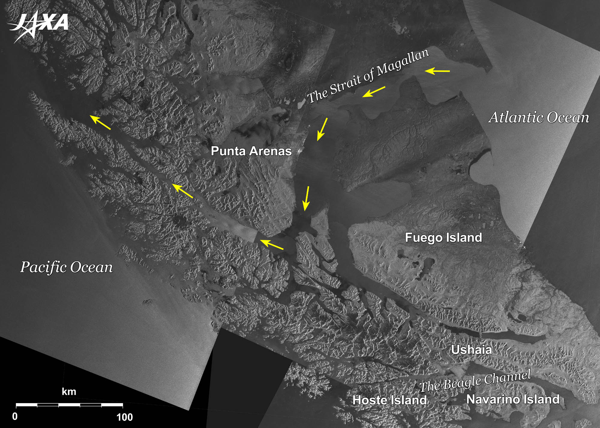
Figure 1 is a composite image of radar imageries from ALOS (“Daichi”) as observed in December 2008 and January 2009. The big island of Fuego (Isla Grande de Tierra del Fuego), with an area of 48,000 km2, is located at the southern tip of Patagonia in South America. The Strait of Magellan separates Tierra del Fuego from the South American Continent, and connects the Atlantic and Pacific Oceans.
Two men are famous for their explorations in the southern South American continent: Ferdinand Magellan, who set sail from Spain in search of a westward route to Southeast Asia, and Charles Darwin, writer of the Origin of Species.
Magellan discovered this strait at the southernmost end of South America in October 1520, and until the Panama Canal was opened for traffic in 1914, the waterway was an important natural passage between the Pacific and Atlantic Oceans for large vessels. However, it was a difficult route to navigate and because of its rapid current, hidden rocks, and unpredictable weather, some vessels took the eastbound route around the Cape of Good Hope, South Africa.
The young naturalist Charles Darwin visited the area on board the survey ship H.M.S. Beagle of the Royal Navy, a voyage that lasted almost 5 years. Darwin spent most of that time on Tierra del Fuego and the surrounding area investigating geology and collecting natural history.
Punta Arenas, the largest city in southern Patagonia, is located in the middle of Figure 1, far along the Strait of Magellan from the mouth of the Atlantic Ocean. Another channel, which separates Tierra del Fuego from Isla Navarino and Isla Hoste, is visible at the lower right of Figure 1. This channel, called the Beagle Channel or the Beagle Canal, is 240 km long and named in honor of the Beagle expedition.
Caption on
Caption off
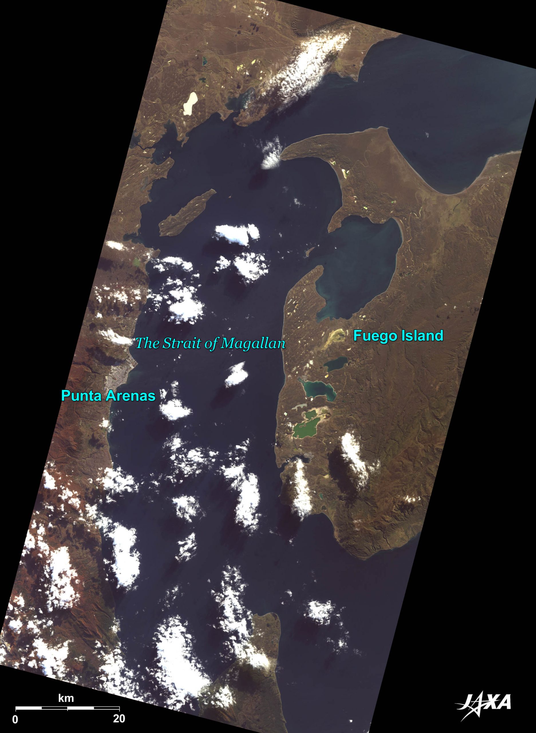
Fig. 2. The Strait of Magellan near Punta Arenas
Punta Arenas (kmz, 3.75 MB, Low Resolution) as seen on Google Earth.
Figure 2 shows the Strait of Magellan near Punta Arenas as observed by ALOS in April 2009. A part of Tierra del Fuego is visible on the right of the image. Punta Arenas, along the coast on the left-hand side, prospered with the discovery of the strait; however, with the opening of the Panama Canal in 1914, it returned to being a quiet town. A monument of Magellan stands in the center of the Plaza de Armas in the middle of town. The Regional Museum of Magellan near the Plaza reminds us of the days of prosperity. Figure 2 reveals that most of the areas of land are forests or prairies. Sheep are grazing in the suburb, making this area the production center of globally famous wool.
Caption on
Caption off
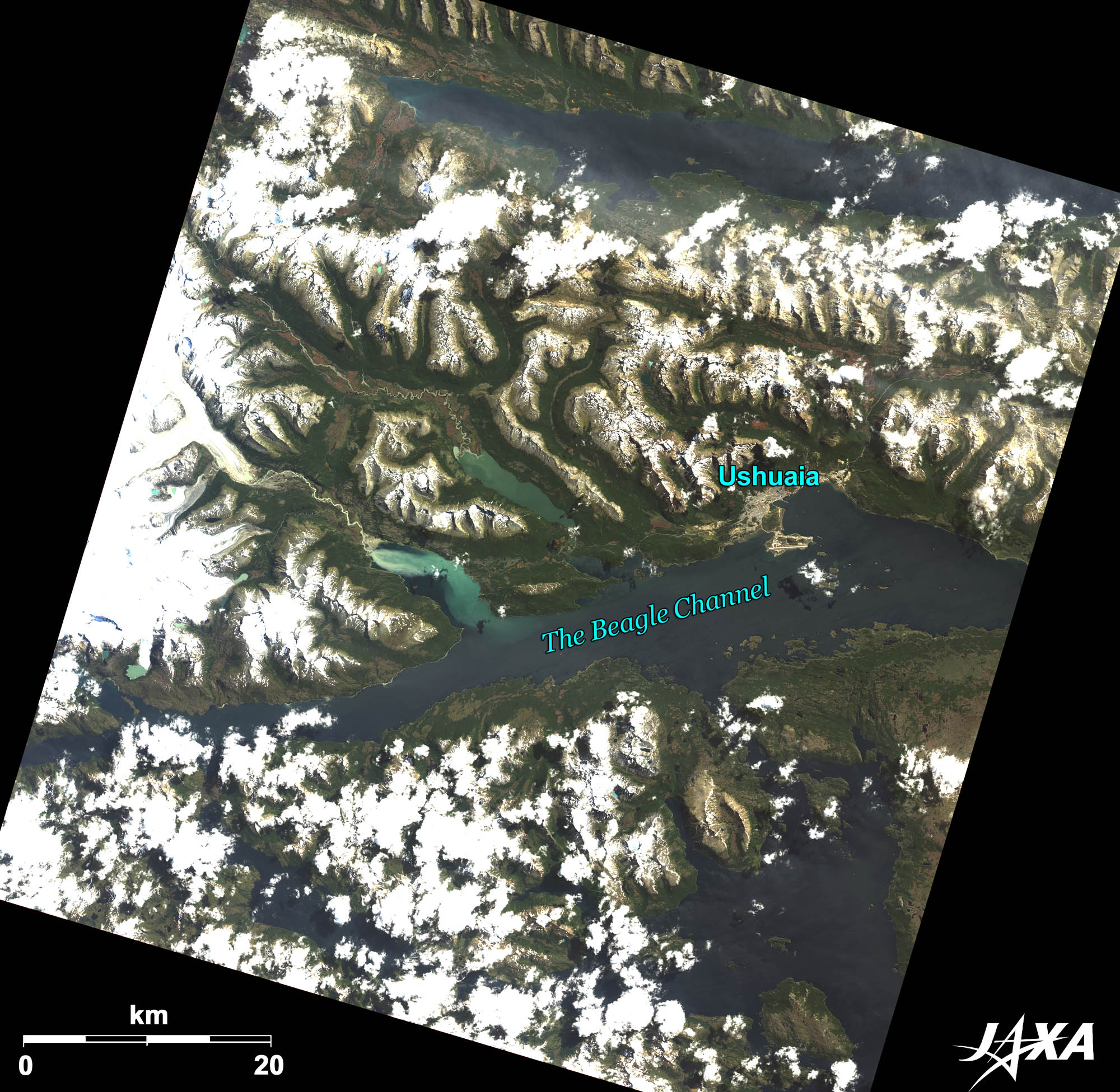
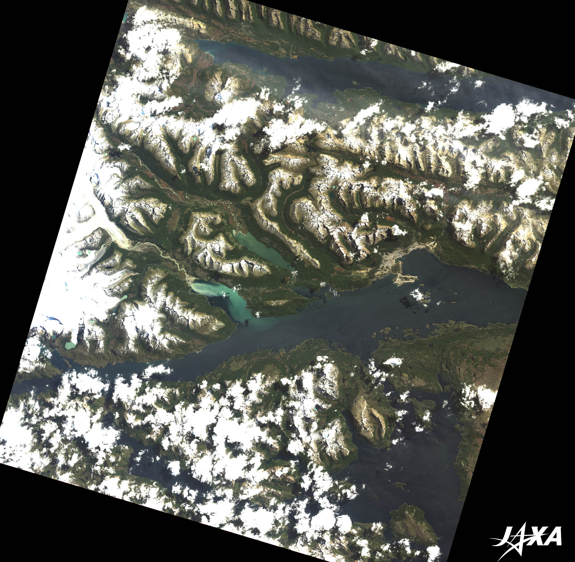
Fig. 3. The Beagle Channel near Ushuaia
Ushuaia (kmz, 3.22 MB, Low Resolution) as seen on Google Earth
Figure 3 shows the vicinity of Ushuaia on the southern coast of Tierra del Fuego as observed by ALOS in January 2008. The white areas are snow, glaciers, or clouds. Ushuaia is known as the world’s southernmost city. The Museum of the End of the World (Museo del Fin del Mundo) highlights displays of the lives and cultures of four tribes who once lived in Tierra del Fuego, as well as many stuffed birds.
Ferdinand Magellan
Ferdinand Magellan (1480-1521) was a Portuguese (later Spanish) explorer. Sponsored by and in order to serve the King of Spain, he set sail in September 1519 in search of a westward route to the “Spice Islands” of Indonesia. One year later in October 1520, he found the Strait of Magellan. In November, he passed through the strait and entered an open sea. Since the sea was calm and peaceful, he named it the Pacific Ocean (“peaceful sea”). He arrived in the Philippines and found he had circumnavigated the world since the Malayan slaves he had brought talked with the local people. (He had travelled eastward to the Malay Peninsula on an earlier voyage.) Although he could not complete the entire voyage, killed in a battle in the Philippines, the remaining crew returned to Spain. Of the 265 men who set out on five ships, only 18 managed to return to Spain on one ship after 3 years.
Charles Robert Darwin
Charles R. Darwin (1809-1882) boarded the survey ship H.M.S. Beagle in December 1831, and set sail from Plymouth, England. While the Beagle surveyed and charted the coasts of South America, Darwin landed and made expeditions inland. He collected many specimens and sent them back to England. Three hundred years after the discovery of Tierra del Fuego by Magellan, on board the Beagle, Darwin stopped there in December 1832. Three Fuegians on board, who had been seized during the first Beagle voyage and had spent a year in England, were taken back to Tierra del Fuego as missionaries. Darwin returned to England after about 5 years of voyage, having passed through the Strait of Magellan in June 1834 and visiting the Galapagos Islands. By that time, he had already gained a growing reputation as a naturalist.
Explanation of the Images:
| Satellite: | Advanced Land Observing Satellite (ALOS) (Daichi) |
| Sensor: | Phased Array type L-band Synthetic Aperture Radar (PALSAR) (Fig. 1) and Advanced Visible and Near Infrared Radiometer-2 (AVNIR-2)(Fig. 2 and 3) |
| Date: | 1417 (UTC) on December 10, 2008 (Fig. 1) 1402 (UTC) on December 29, 2008 (Fig. 1) 1416 (UTC) on January 23, 2009 (Fig. 1) 1429 (UTC) on April 20, 2009 (Fig. 2) 1415 (UTC) on January 23, 2008 (Fig. 3) |
| Ground resolution: | 100 m (PALSAR Scan SAR Mode) and 10 m (AVNIR-2) |
| Map Projection: | Universal Transversal Mercator (UTM) |
Figure 1 is a black and white image by PALSAR. In general, smooth areas indicate water surfaces and blocky areas indicate land.
AVNIR-2 has four observation bands. The color composite images (Fig. 2 and 3) are usually produced by assigning red to Band 3 (610 to 690 nm), green to Band 2 (520 to 600 nm), and blue to Band 1 (420 to 500 nm). The resulting images have natural coloring as if seen by the naked eye. Thus, each color indicates the following ground objects:
| Blue or Bluish-green: | Water surfaces |
| Grey: | Urban areas |
| Brown: | Forests |
| Light brown or Green: | Grass fields |
| White: | Snow or clouds |
Search by Year
Search by Categories


Tags
-
#Earthquake
-
#Land
-
#Satellite Data
-
#Aerosol
-
#Public Health
-
#GCOM-C
-
#Sea
-
#Atmosphere
-
#Ice
-
#Today's Earth
-
#Flood
-
#Water Cycle
-
#AW3D
-
#G-Portal
-
#EarthCARE
-
#Volcano
-
#Agriculture
-
#Himawari
-
#GHG
-
#GPM
-
#GOSAT
-
#Simulation
-
#GCOM-W
-
#Drought
-
#Fire
-
#Forest
-
#Cooperation
-
#Precipitation
-
#Typhoon
-
#DPR
-
#NEXRA
-
#ALOS
-
#GSMaP
-
#Climate Change
-
#Carbon Cycle
-
#API
-
#Humanities Sociology
-
#AMSR
-
#Land Use Land Cover
-
#Environmental issues
-
#Quick Report
-
#GOSAT-GW
Related Resources


Related Tags
Latest Observation Related Articles
-
 Latest Observation 2026.06.05 Fri [Quick Report] Typhoon No. 6, “JANGMI”, brought heavy rain to Japan. – Results of satellite data analysis –
 -
 Latest Observation 2026.04.16 Thu [Quick Report] EarthCARE Captured the Eye of Typhoon Sinlaku
 -
 Latest Observation 2025.12.03 Wed [Quick Report] Analysis results from satellite precipitation data on the record-breaking heavy rainfall occurring in Southeast Asia in late November 2025
 -
 Latest Observation 2025.10.01 Wed [Quick Report] Hurricane Humberto “Eye” captured by EarthCARE satellite (Hakuryu)
Stay Connected
