


Latest Observation
2010.09.01 Wed
Amanohashidate and Maizuru, Japan
caption on
caption off
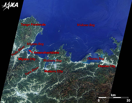
Figure 1 is an image of the western part of Wakasa Bay taken by ALOS (“Daichi”) in April 2009. Wakasa Bay consists of some smaller inlets, such as Obama Bay seen on the right of the image and Miyazu Bay on the left. The narrow arch-shaped sandbar, named Amanohashidate, on the left side of the image, is located in Miyazu City. In the middle of the image is Maizuru City, which has developed as a port city. Separating the two cities is the Yura River. Wakasa Bay has a complex ria coastline. If you look closely, you can see the striped patterns of red tide in Wakasa Bay, which broke out at the time the image was taken.
Sand flowing out from the rivers at the east side of the Tango Peninsula accumulated and created a sandbar when a stream collided with the flow of the Noda River west of Amanohashidate. Amanohashidate is well known as one of Japan’s Three Scenic Views; the other two are Matsushima in Miyagi Prefecture and Miyajima in Hiroshima Prefecture.
caption on
caption off
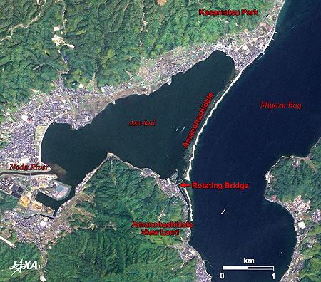
Fig. 2. Enlarged Image of Amanohashidate
Amanohashidate (kmz, 3.91 MB, Low Resolution) as seen on Google Earth
Figure 2 is an enlarged image of Amanohashidate. The 3.6-m-long sandbar reaches widths of between 20 m to 170 m, is covered with about 8,000 pine trees, and can be traversed on foot. The zigzag-shaped coastline facing the ocean is sand accumulated at dikes, which have been built to prevent the sand from flowing farther out.
When seen upside-down from the observation deck, the sandbar looks like a bridge spanning the sky, and is thus named Amanohashidate. Viewing the scenery upside-downupside-down between your legs from Kasamatsu Park at the north is recommended. The view from Amanohashidate Viewland at the top of Monju Mountain in the south is also famous. From this angle, the sandbar appears to be a dragon climbing up to the sky.
A swing bridge, which connects the mainland to Amanohashidate, is located on the southern edge of the sandbar. It swings 90 degrees when a ship crosses the channel. There was a ferry service called Kusedo before the bridge was built. In 1923, a bridge swung by hand was built, which was later converted to an electrically swinging bridge in May 1960 when the frequency of large ships passing increased.
caption on
caption off
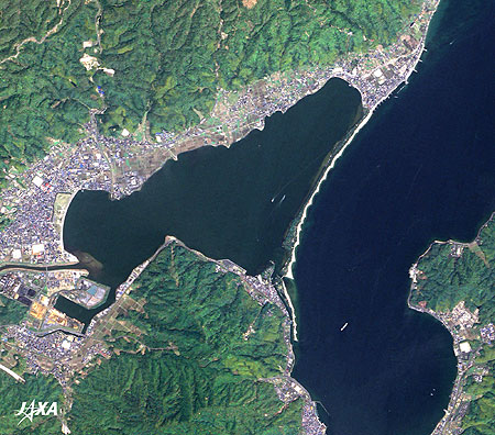
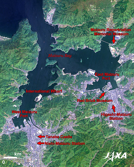
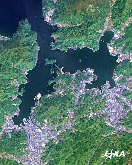
Figure 3 is an enlarged image of Maizuru. Maizuru consists of Higashi-Maizuru (East Maizuru) and Nishi-Maizuru (West Maizuru). Originally, Higashi-Maizuru was a naval port. Some red-brick warehouses built in the early 1900s that were used to store munitions remain there. The Red Brick Museum, whose main display theme is brick, is one of the oldest brick buildings with steel frames in Japan.
Nishi-Maizuru was developed as a castle town. Tanabe Castle was built by the Hosokawa family in the warring state period. The remains of Tanabe Castle have been converted into Maizuru Park.
Since there was no pier for large vessels at Maizuru port, an international wharf was constructed at the West Maizuru Port. The multi-purpose international port, where 50-kiloton-class container vessels can berth, started its service in April 2010. Sea routes to China and Korea from Maizuru are now in service. The international port under construction is visible in the image.
A Mother at the Pier
After the Second World War, Maizuru was a key port for returning Japanese servicemen and detainees from continental Asia. More than 660,000 people landed at Maizuru Port from 1945 to 1958. Many families and relatives gathered alongside the pier when repatriation ships arrived from the ex-Soviet Union. Among them, one mother waiting for her son was widely noticed. She was referred to as “A mother at the Pier” and featured in a movie and a popular song. Maizuru Repatriation Memorial Park was constructed at the top of the hill and overlooks the landing pier. The Memorial Museum was built in 1988.
Explanation of the Images:
| Satellite: | Advanced Land Observing Satellite (ALOS) (Daichi) |
| Sensor: |
Advanced Visible and Near Infrared Radiometer-2 (AVNIR-2) Panchromatic Remote-sensing Instrument for Stereo Mapping (PRISM) |
| Date: | 01:52 (UTC) on April 19, 2009 (AVNIR-2, PRISM) |
| Ground resolution: | 10 m (AVNIR-2) and 2.5 m (PRISM) |
| Map Projection: | Universal Transversal Mercator (UTM) |
AVNIR-2 has four observation bands. The color composite images are produced by assigning red to Band 3 (610 to 690 nm), green to Band 2 (520 to 600 nm) and blue to Band 1 (420 to 500 nm). The resulting images have natural coloring as if seen by the naked eye. Each color indicates the following ground objects:
| Dark Green: | Forests |
| Bright green: | Forests, grass fields, farmland |
| Bright grey: | Urban areas |
| Brown: | Bare land |
| Blue: | Sea surface |
| White: | Buildings or sand |
PRISM is an optical sensor for observing ground surfaces with visible and near-infrared signals in the 520- to 770-nanometer (one-billionth of a meter) band. The image is monochromatic but has a higher resolution. PRISM has three independent optical systems to acquire images in the view of nadir, forward, and backward simultaneously. Only the nadir images are used in these figures.
The above AVNIR-2 color composite image is decomposed into, hue, saturation, and intensity. The intensity portion is replaced by PRISM data. The hue, saturation, and intensity data are then reversed into a color image. This color image has a virtual 2.5-m resolution. A color image composed by combining a higher resolution monochromatic image and a lower resolution color image is called a pan-sharpened image.
Fukuoka, a city boasting international exchanges and a long history
Search by Year
Search by Categories


Tags
-
#Earthquake
-
#Land
-
#Satellite Data
-
#Aerosol
-
#Public Health
-
#GCOM-C
-
#Sea
-
#Atmosphere
-
#Ice
-
#Today's Earth
-
#Flood
-
#Water Cycle
-
#AW3D
-
#G-Portal
-
#EarthCARE
-
#Volcano
-
#Agriculture
-
#Himawari
-
#GHG
-
#GPM
-
#GOSAT
-
#Simulation
-
#GCOM-W
-
#Drought
-
#Fire
-
#Forest
-
#Cooperation
-
#Precipitation
-
#Typhoon
-
#DPR
-
#NEXRA
-
#ALOS
-
#GSMaP
-
#Climate Change
-
#Carbon Cycle
-
#API
-
#Humanities Sociology
-
#AMSR
-
#Land Use Land Cover
-
#Environmental issues
-
#Quick Report
-
#GOSAT-GW
Related Resources


Related Tags
Latest Observation Related Articles
-
 Latest Observation 2026.06.05 Fri [Quick Report] Typhoon No. 6, “JANGMI”, brought heavy rain to Japan. – Results of satellite data analysis –
 -
 Latest Observation 2026.04.16 Thu [Quick Report] EarthCARE Captured the Eye of Typhoon Sinlaku
 -
 Latest Observation 2025.12.03 Wed [Quick Report] Analysis results from satellite precipitation data on the record-breaking heavy rainfall occurring in Southeast Asia in late November 2025
 -
 Latest Observation 2025.10.01 Wed [Quick Report] Hurricane Humberto “Eye” captured by EarthCARE satellite (Hakuryu)
Stay Connected
