
Latest Observation
2010.07.21 Wed
Kurobe Dam: a Popular Site of Summer Tourism in Japan
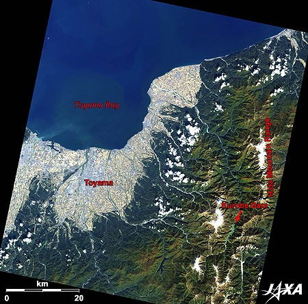
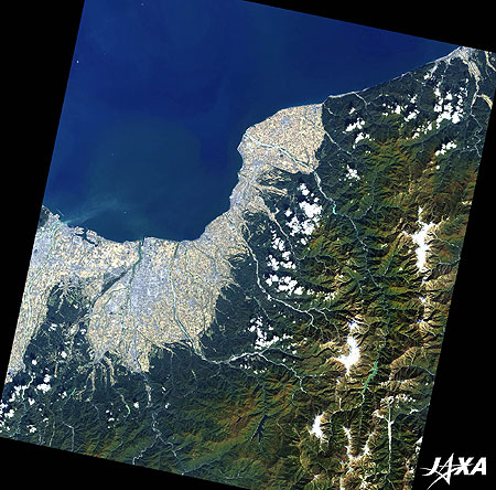
Figure 1 depicts Toyama Prefecture, Japan, and its vicinity as observed by ALOS (“Daichi”) in October 2009. Toyama Prefecture, with a population of 1.1 million, faces bountiful Toyama Bay to the north, and is surrounded on the other three sides mostly by mountainous regions, including the Hida Mountain Range.
About 500 kinds of marine life can be found in Toyama Bay (there are 800 in the entire Japan Sea), which, in particular, abounds with adult yellowtails, firefly squids, and glass shrimps (Pasiphaea japonica). The bay is deep and mirages sometimes appear in winter and spring.
The Hida Mountain Range, in the east, is commonly called the Northern Alps, and its main attraction is Chubu Sangaku (meaning Central Mountain) National Park. Natural beauties are reserved here among ptarmigans, a national treasure, and various alpine floras. Four areas in this prefecture hold honorable positions in both the “Top 100 Spring Water Brand Names” and “Japan’s 100 Best Spring Water Sites of the Heisei Era.”
caption on
caption off
Fig. 2. Vicinity of Lake Kurobe
Vicinity of Lake Kurobe (kmz, 5.08 MB, Low Resolution) as seen on Google Earth
Kurobe Dam after Arduous Construction
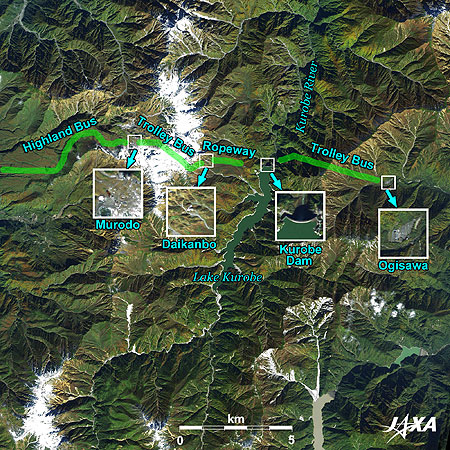
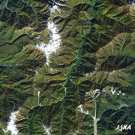
Moving south along the Hida Mountain Range, the emerald green Lake Kurobe (Fig. 2) appears in the steep mountains. Lake Kurobe was created by Kurobe Dam. The dam stands 186 meters high (the highest in Japan), 492 meters wide, and holds 200 million cubic meters of water. It is one of the largest dams in the world. Its water supplies the No. 4 Hydraulic Power Generation Plant on the Kurobe River.
It is well known that the construction of Kurobe Dam was extremely arduous.
About 10 years after World War II, Japanese industries had been restored and were showing signs of further growth. However, the Kansai area (western Japan) lapsed into a chronic electric power shortage and suffered from frequent power outages.
In 1956, Kansai Electric Power Co., Inc. decided to construct a dam in the Tateyama-Kurobe area. Although, this project adopted state-of-the-art technologies and knowledge, construction lumbered due to the upland area of difficult terrain and hard climate. The extremely difficult project, finally completed in 1963, produced many casualties during the construction and cost 51.3 billion yen, as well as the efforts of 10 million workers.
Many fierce episodes from the time of Kurobe Dam’s construction remain in people’s mind as “The Great Undertaking of the Century,” and are featured in various media, such as movies, TV dramas, and documentaries.
Kurobe Gorge in Summer, Crowded with Tourists
The steep walls of Kurobe Gorge extend into the valley from the middle of the Kurobe River to the upper stream.
This precipitous geographical feature was created through erosion by torrents of affluent thaw water running down the Kurobe River, and since this area is almost inaccessible, it was selected as one of the “Top 100 Hidden Places of Japan.”
However, a section of the gorge is one of the most popular tourist spots in Japan. Truck trains of Kurobe-kyoukoku (gorge) Railway Co. operate over 20 km between Unazuki Hot Spring and Keyakidaira from May to November. The trains pass 22 bridges and 41 tunnels and offer passengers grand views of natural landscapes. Hot springs on the riverside along the railway track also attract people.
Corridors used in the construction of the dam are also open to visitors as the “Tateyama-Kurobe Alpine Route.” This mountain tourism route connects the 90-km stretch between Tateyama Station at Tateyama-cho (town), Toyama Prefecture, and Ōgisawa Station at Ōmachi City, Nagano Prefecture, with cable railways, highland busses, trolley busses, and aerial tramways. Major spots along the route are enlarged four times in Figure 2.
Midway along the route, visitors may walk on the bank of Kurobe Dam. The dam discharges water during the tourist season, which starts on June 26 and ends on October 15. From the arch-shaped concrete dam, more than 10 cubic meters of water drop every second to the Kurobe River below, creating a rising white cloud of spray and a great roar throughout the valley.
The perfect combination of artificial dam and wild nature surely comfort visitors’ hearts.
Explanation of the Images:

| Satellite: | Advanced Land Observing Satellite (ALOS) (Daichi) |
| Sensor: |
Advanced Visible and Near Infrared Radiometer-2 (AVNIR-2) Panchromatic Remote-sensing Instrument for Stereo Mapping (PRISM) |
| Date: | 0146 (UTC) on October 15, 2009 (Simultaneous observation of AVNIR-2 and PRISM) |
| Ground resolution: | 10 m (AVNIR-2) and 2.5 m (PRISM) |
| Map Projection: | Universal Transversal Mercator (UTM) |
AVNIR-2 has four observation bands. The composite images are usually produced by assigning red to Band 3 (610 to 690 nm), green to Band 2 (520 to 600 nm), and blue to Band 1 (420 to 500 nm). The resulting images have natural coloring as if seen by the naked eye. Thus, the following colors designate ground objects:
| Dark Green: | Forests |
| Light Yellow-green: | Grass fields |
| Brown: | Bare ground |
| Blue: | Water surface |
| White: | Buildings, clouds, or snow |
PRISM is an optical sensor for observing ground surfaces with visible and near-infrared signals in the 520- to 770-nanometer (one-billionth of a meter) band. The acquired image is monochrome. PRISM has three independent optical systems (telescopes) to acquire images for nadir, forward, and backward views simultaneously. Only the nadir image was used in this article.
The above AVNIR-2 composite image was then transformed into hue, saturation, and intensity, and the intensity was replaced by the PRISM image. The hue, saturation, and intensity data were then reversed into a color image. As a result, a virtual 2.5-m ground-resolution color image was obtained. This kind of high-resolution color image, composed by combining the higher resolution monochrome image and the lower resolution color image, is called a pan-sharpened image. Figure 2 is a high-resolution, pan-sharpened image composed this way.
Search by Year
Search by Categories
Tags
-
#Earthquake
-
#Land
-
#Satellite Data
-
#Aerosol
-
#Public Health
-
#GCOM-C
-
#Sea
-
#Atmosphere
-
#Ice
-
#Today's Earth
-
#Flood
-
#Water Cycle
-
#AW3D
-
#G-Portal
-
#EarthCARE
-
#Volcano
-
#Agriculture
-
#Himawari
-
#GHG
-
#GPM
-
#GOSAT
-
#Simulation
-
#GCOM-W
-
#Drought
-
#Fire
-
#Forest
-
#Cooperation
-
#Precipitation
-
#Typhoon
-
#DPR
-
#NEXRA
-
#ALOS
-
#GSMaP
-
#Climate Change
-
#Carbon Cycle
-
#API
-
#Humanities Sociology
-
#AMSR
-
#Land Use Land Cover
-
#Environmental issues
-
#Quick Report
Related Resources
Related Tags
Latest Observation Related Articles
-
 Latest Observation 2025.12.03 Wed [Quick Report] Analysis results from satellite precipitation data on the record-breaking heavy rainfall occurring in Southeast Asia in late November 2025
 -
 Latest Observation 2025.10.01 Wed [Quick Report] Hurricane Humberto “Eye” captured by EarthCARE satellite (Hakuryu)
 -
 Latest Observation 2025.02.28 Fri The world’s largest iceberg, A23a, may have run aground on the continental shelf of South Georgia:
The trajectory of iceberg A23a observed by “GCOM-W”, “ALOS-2” and “ALOS-4” -
 Latest Observation 2024.11.06 Wed [Quick Report] Heavy rainfalls in eastern Spain, as seen by the Global Satellite Mapping of Precipitation (GSMaP)


