


Latest Observation
2010.06.09 Wed
The Salt Flat of Uyuni, Bolivia: The Largest Mirror Lake in the World


Caption on
Caption off
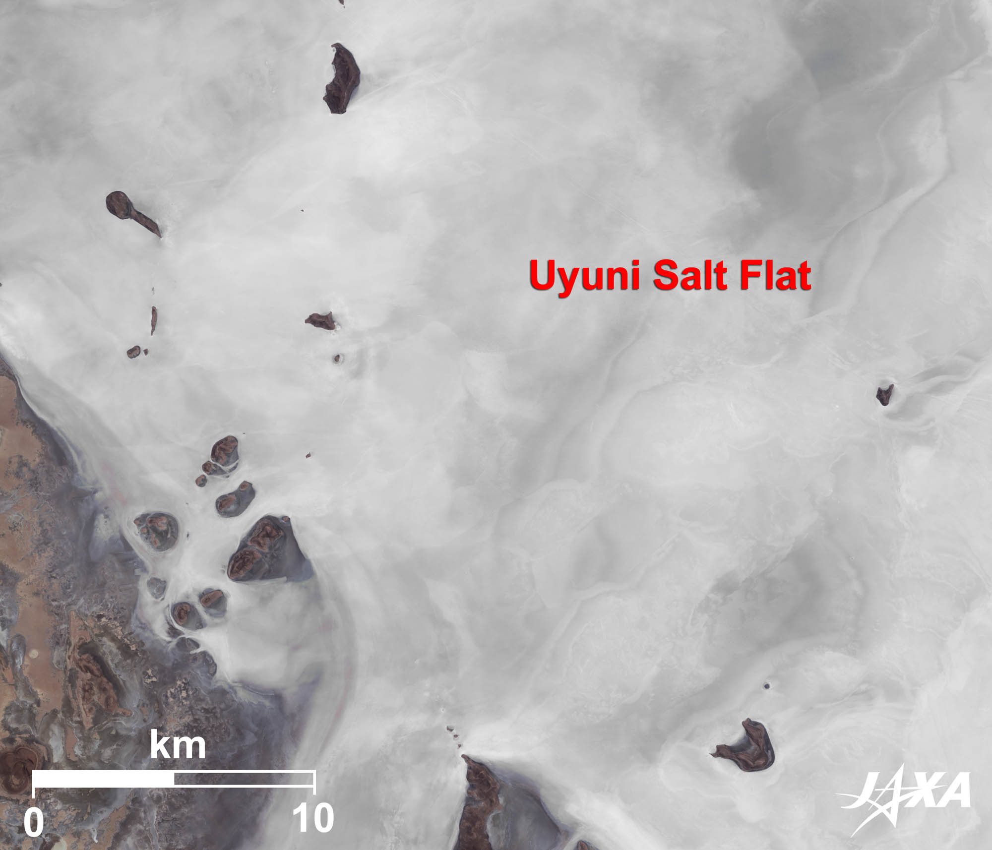
Figure 1 is a mosaic image of the Salt Flat of Uyuni (Sala de Uyuni), Bolivia, taken by ALOS (Daichi) in March and April 2010 and May 2009. The white area in the center of the image is the salt flat. The flat is 100 km north-to-south and 150 km east-to-west, with an area of 12,000 km2. It is about 3,700 m above sea level. The surface is exceptionally flat and when covered by water during the rainy season (from December to May) a huge mirror appears and reflects the heavens. The cerulean water melding with the clouds and sky is a surreal vision.
The Andes, including Bolivia, was once a seabed. When the crust lifted up, creating the mountainous region, the enclosed sea became lakes. The lakes dried up and left behind the salt flats. There are still small salt lakes around the Salt Flat of Uyuni.
Caption on
Caption off
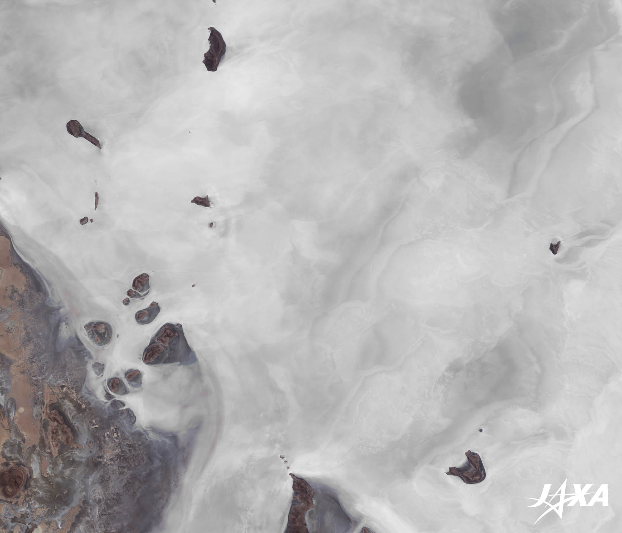
Fig. 2. Small Islands in the Salt Flat of Uyuni
The Salt Flat of Uyuni (kmz, 1.17 MB, Low Resolution) as seen on Google Earth
Figure 2 shows small islands in the salt flat. The islands are reefs and covered by coral fossils. This tells us that this area was once under the sea. The islands are called Isola des Pescado in Spanish, meaning “Fish Islands.” Big cactuses, planted by the Inca, grow on the islands. During the dry season (from June to November), the area is covered by white salt and the cactuses in the snowy landscape produce a marvelous scene.
There are some hotels made with salt in and around the salt flat. A famous hotel on the east side of the salt flat is made mostly by salt blocks, including its interior.
Caption on
Caption off
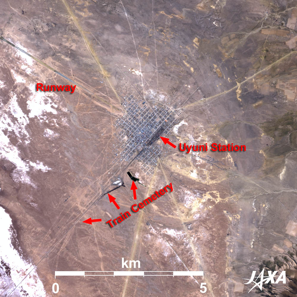
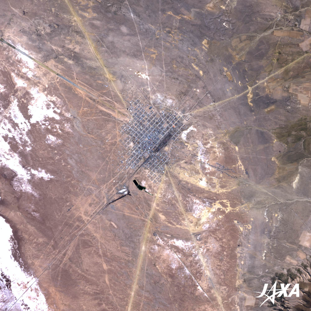
Figure 3 shows Uyuni City, located on the east coast of the salt flat. Its population is about 14,000 and most of them are Indigenas (indigenous people). Many old abandoned trains are seen outside of the town on the railway track extending towards the southwest terminal. This is called the “Train Cemetery.” Older trains are abandoned even further away from the town. The last train was discarded more than 100 years ago.
A British sponsored company had maintained the railroad network in Bolivia. When the railroad network was nationalized, the British engineers withdrew without transferring the technology to the local people. The railroad networks were closed and the trains were abandoned, creating the train cemetery.
Salt of the Andes
Salt of the Andes is famous for its rich and good balance of minerals. There are two kinds of salt: red (rock salt) and white (lake salt). Red salt, rich in iron, is mined in the Andes at an elevation of 3,500 m to 4,500 m. White salt is found naturally in the Salt Flat of Uyuni. Both kinds of salt were made from deep sea water.
Lithium Resources
Every endeavor of the automotive industry in recent years is concentrated on the development of electric and hybrid cars. Lithium is the indispensable source of lithium ion batteries. Much lithium is found in South America. In particular, the Uyuni area holds about half (around 5.5 million tons) of the world’s lithium deposits. The Japan Oil, Gas and Metals National Corporation (JOGMEC) offered the Bolivian Government to develop the lithium resources in Uyuni in collaboration with Bolivian companies.
Explanation of the Images:
| Satellite: | Advanced Land Observing Satellite (ALOS) (Daichi) |
| Sensor: | Advanced Visible and Near Infrared Radiometer-2 (AVNIR-2) |
| Date: | 1445 (UTC) on May 10, 2009 (Fig. 1 and Fig. 3) 1450 (UTC) on March 16, 2010 (Fig. 1) 1452 (UTC) on April 2, 2010 (Fig. 1 and Fig. 2) 1448 (UTC) on April 14, 2010 (Fig. 1) |
| Ground resolution: | 10 m |
| Map Projection: | Universal Transversal Mercator (UTM) |
AVNIR-2 has four observation bands. Figures 1 and 2 are first produced by assigning red to Band 3 (610 to 690 nm), green to Band 2 (520 to 600 nm) and blue to Band 1 (420 to 500 nm). Then those composite images are decomposed into hue, saturation, and intensity. The intensity portion is replaced by Band 4 (760 to 890 nm). Snow and ice have strong reflections. If the original color images are not decomposed, snow and ice portions appear pure white. The replaced images have natural coloring as if seen by the naked eye. Each color indicates the following ground objects:
| Dark Bluish-grey: | Urban areas |
| Reddish-brown: | Bare grounds or rocky tract |
| White: | Salt or cloud |
| Black: | Water surface |
Related Sites
Search by Year
Search by Categories


Tags
-
#Earthquake
-
#Land
-
#Satellite Data
-
#Aerosol
-
#Public Health
-
#GCOM-C
-
#Sea
-
#Atmosphere
-
#Ice
-
#Today's Earth
-
#Flood
-
#Water Cycle
-
#AW3D
-
#G-Portal
-
#EarthCARE
-
#Volcano
-
#Agriculture
-
#Himawari
-
#GHG
-
#GPM
-
#GOSAT
-
#Simulation
-
#GCOM-W
-
#Drought
-
#Fire
-
#Forest
-
#Cooperation
-
#Precipitation
-
#Typhoon
-
#DPR
-
#NEXRA
-
#ALOS
-
#GSMaP
-
#Climate Change
-
#Carbon Cycle
-
#API
-
#Humanities Sociology
-
#AMSR
-
#Land Use Land Cover
-
#Environmental issues
-
#Quick Report
-
#GOSAT-GW
Related Resources


Related Tags
Latest Observation Related Articles
-
 Latest Observation 2026.06.05 Fri [Quick Report] Typhoon No. 6, “JANGMI”, brought heavy rain to Japan. – Results of satellite data analysis –
 -
 Latest Observation 2026.04.16 Thu [Quick Report] EarthCARE Captured the Eye of Typhoon Sinlaku
 -
 Latest Observation 2025.12.03 Wed [Quick Report] Analysis results from satellite precipitation data on the record-breaking heavy rainfall occurring in Southeast Asia in late November 2025
 -
 Latest Observation 2025.10.01 Wed [Quick Report] Hurricane Humberto “Eye” captured by EarthCARE satellite (Hakuryu)
Stay Connected
