


Latest Observation
2010.05.26 Wed
Lushun and Dalian: Two Ports on the Liaodong Peninsula
caption on
caption off
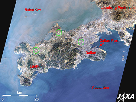
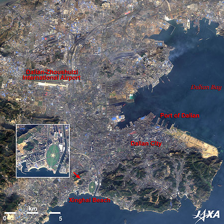
Figure 1 depicts the southern tip of the Liaodong Peninsula in China as observed by ALOS (“Daichi”) in November 2009. The peninsula juts out toward the Shandong Peninsula located at the opposite coast of the Bohai Sea. The difference in ocean colors between the north side and south side of the peninsula indicates that turbid water flows into the south from the north. Lushun is located on the left and Dalian is on the right of the central mountain massif. Three airports (indicated by green circles) are also visible. The rightmost one is Dalian Airport (Dalian Zhoushuizi International Airport). The bright portion on the cape to the east of Dalian is an area under development.
caption on
caption off
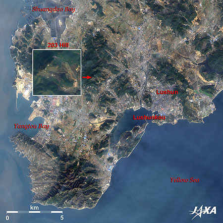
Fig. 2. Enlarged Image of Lushun
Lushun (kmz, 4.05 MB, Low Resolution) as seen on Google Earth
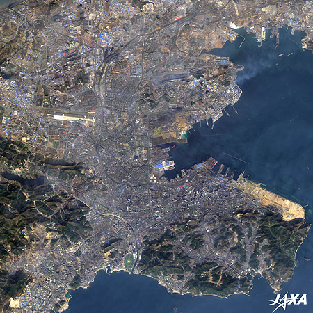
Figure 2 presents an enlarged image of Lushun. Lushun once merged with Dalian and was called Luda, but today, it is incorporated by Dalian and serves as Lushunkou District of Dalian City. Development is also in progress at the western area facing the Bohai Sea.
Lushun was a bloody battlefield during the Russo-Japanese War. The Imperial Japanese Navy, led by Admiral Heihachiro Togo, tried to sink ships at the narrow entrance of Port Lushun (the western name is Port Arthur) to seal and blockade the Russian fleet anchored at the port. However, this operation was unsuccessful, and as a result, his fleet had to besiege the port for many months. Since 203 Hill at the northwest of Lushun provides good visibility of the port, capture of the hill was strategically very important to Japan. The Japanese Army, led by General Maresuke Nogi, and the defending Russian Army battled fiercely to capture this hill. After the fall of the hill, Nogi’s army was able to bombard and destroy the Russian fleet in the harbor. This battle turned the tide of the war to the advantage of the Japanese.
Today, aquafarming of scallops, oysters, little clams, brown sea weed, and kelp is quite active in and outside the port and much of it is exported to Japan, South Korea, and the United States. However, demand at home has been growing in recent years.
The Lushun New Port area at Shuangdao Bay and Yangtou Bay, facing the Bohai Sea on the west of the peninsula, is aiming at formation of a traffic energy institution base, with construction of various industrial facilities. Abandoned salt fields are also visible at Shuangdao Bay.
caption on
caption off
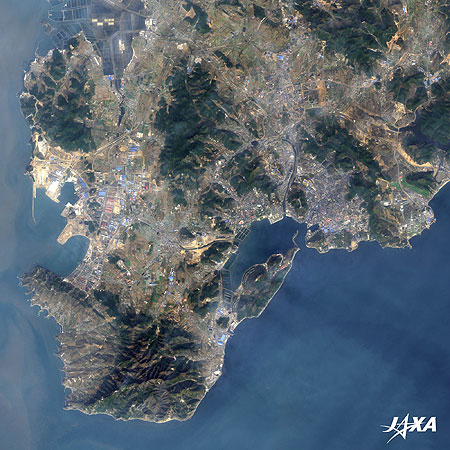
Fig. 3. Enlarged Image of Dalian
Dalian (kmz, 4.65 MB, Low Resolution) as seen on Google Earth
Figure 3 is an enlarged image of Dalian. Dalian Zhoushuizi International Airport is visible at the upper left and the Port of Dalian is located to the right. At the end of nineteenth century, Russia wanted to acquire an ice-free port in the Far East and began construction of the Port of Dalian. After the Russo-Japanese War, Japan took over this trade. Since this port was the gateway to northern China, ferries connected Japan and Dalian. Railway tracks were extended to the piers allowing passengers to disembark from the second deck and board a train from the ground floor.
The cityscape of Dalian has a Russian atmosphere when acacia is in full bloom in May. Xinghai Beach, a famous summer resort, is visible at the bottom of the image.
Dalian is designated as the Dalian Development Area and has achieved remarkable economic development with construction of a software park, etc., in recent years.
Opening of Lushun
Lushun was off-limits to foreigners for many years. Although, in 1996, the northwestern section of the town, including 203 Hill, was opened and at the end of 2009, the city was more thoroughly opened, apart from military facilities and their surroundings. Investments by Japanese companies and increased tourism from Japan are highly welcomed by the city.
Dalian’s Environmental Model Area Development Plan
From December 1996 to March 2000, Kitakyushu City in Japan and the Japan International Cooperation Agency (JICA) made an investigation and prepared a master plan for development and environmental improvement of the area under the Official Development Assistance (ODA) Charter. It is a comprehensive improvement plan, targeting 2010, with regard to atmospheric and water pollution, and technologies have been transferred to the experts of Dalian. Dalian has been tackling pollution problems caused by automobiles and waste, and it is now well known as an environmentally advanced city in China.
Images of ALOS (Daichi) are used on the “JAL MAP” web page. You see satellite images when you click on the “Satellite Image” button at the upper right of the map. The background image then changes to a satellite image. You can see Dalian on this site as well.
Explanation of the Images:
| Satellite: | Advanced Land Observing Satellite (ALOS) (Daichi) |
| Sensor: | Advanced Visible and Near Infrared Radiometer-2 (AVNIR-2) |
| Date: | 0251(UTC) on November 15, 2009 |
| Ground resolution: | 10 m |
| Map Projection: | Universal Transversal Mercator (UTM) |
(図1〜3)
AVNIR-2 has four observation bands. The color composite images are usually produced by assigning red to Band 3 (610 to 690 nm), green to Band 2 (520 to 600 nm), and blue to Band 1 (420 to 500 nm). In the above images, green is assigned to the sum of 90 percent of Band 2 and 10 percent of Band 4 (760 to 890nm), which improves the visibility of vegetation and the resulting images have natural coloring as if seen by the naked eye. Thus, each color indicates the following ground objects:
| Dark Green: | Forests |
| Bright Green: | Farmlands |
| Light Bluish-grey: | Urban areas |
| Brown: | Bare ground |
| Blue: | Sea surface |
| White: | Buildings, or snow |
Shanghai: A Dynamic City
Beijing in the Long History of China
Kitakyushu and Shimonoseki Cities meet across Kanmon Strait
Search by Year
Search by Categories


Tags
-
#Earthquake
-
#Land
-
#Satellite Data
-
#Aerosol
-
#Public Health
-
#GCOM-C
-
#Sea
-
#Atmosphere
-
#Ice
-
#Today's Earth
-
#Flood
-
#Water Cycle
-
#AW3D
-
#G-Portal
-
#EarthCARE
-
#Volcano
-
#Agriculture
-
#Himawari
-
#GHG
-
#GPM
-
#GOSAT
-
#Simulation
-
#GCOM-W
-
#Drought
-
#Fire
-
#Forest
-
#Cooperation
-
#Precipitation
-
#Typhoon
-
#DPR
-
#NEXRA
-
#ALOS
-
#GSMaP
-
#Climate Change
-
#Carbon Cycle
-
#API
-
#Humanities Sociology
-
#AMSR
-
#Land Use Land Cover
-
#Environmental issues
-
#Quick Report
-
#GOSAT-GW
Related Resources


Related Tags
Latest Observation Related Articles
-
 Latest Observation 2026.06.05 Fri [Quick Report] Typhoon No. 6, “JANGMI”, brought heavy rain to Japan. – Results of satellite data analysis –
 -
 Latest Observation 2026.04.16 Thu [Quick Report] EarthCARE Captured the Eye of Typhoon Sinlaku
 -
 Latest Observation 2025.12.03 Wed [Quick Report] Analysis results from satellite precipitation data on the record-breaking heavy rainfall occurring in Southeast Asia in late November 2025
 -
 Latest Observation 2025.10.01 Wed [Quick Report] Hurricane Humberto “Eye” captured by EarthCARE satellite (Hakuryu)
Stay Connected
