


Latest Observation
2010.02.24 Wed
Mohenjo-daro: An Amazingly Developed City
Mohenjo-daro (meaning “Mound of the Dead”), located in the province of Sindh in south Pakistan, is the ruins of a city of the Indus Valley Civilization (3,300-1,700 B.C.). It is one of the Four Great Ancient Civilizations and has been added to the World Heritage of UNESCO list. The Indus River, which originates at Tibet, formed fertile land downstream and spawned the development of agriculture and the Indus Valley Civilization. Cities of the Indus Valley Civilization appeared around 2,300 B.C. and Mohenjo-daro (3,300-1,700 B.C.) is the most famous of them along with Harappa, which is located about 600 km upstream of the Indus River.
caption on
caption off
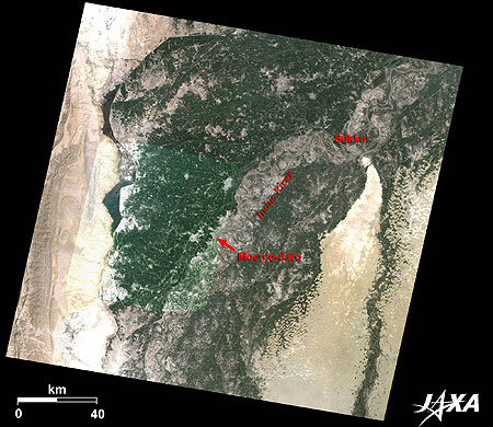
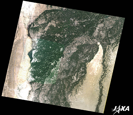
Figure 1 shows Mohenjo-daro and its vicinity as observed by Landsat-5 in September 2009, on which the image taken by ALOS (“Daichi”) in the same month was overlaid. The light brown areas on both sides of the image are deserts in southern Pakistan. The green areas in the center of the image are farmlands on the 100-kilometer-wide river basin of the Indus River, which flows from the north (top) to the south (bottom).
Mohenjo-daro was discovered by Indian archaeologist R. D. Bandyopadhyay (or Banerjee) in 1921. Until then, it had been thought that Mohenjo-daro was Buddhist ruins from the second to third century. During the investigation at the site, seals symbolizing the Indus Valley Civilization were discovered underneath the Buddhist ruins and the site was proven to be the ruins of a developed city.
Mohenjo-daro is located in the middle of the image along the Indus River. The site is about 1.6 kilometers square. It was the largest city among the cities of the Indus Valley Civilization but was smaller than the large cities in the Mesopotamian civilization that thrived about 1,000 years earlier.
It is thought that the Dravidian people played the leading role in the Indus Valley Civilization and that the estimated population of Mohenjo-daro was between 30,000 and 40,000, but most of them now live in South India.
caption on
caption off
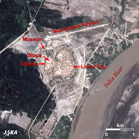
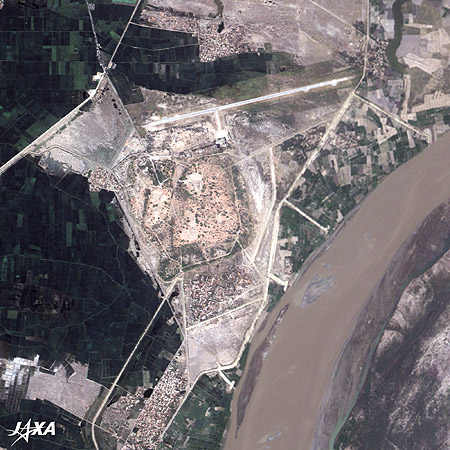
Fig. 2. Close-up Image of Mohenjo-daro
Ruins of Mohenjo-daro (kmz, 4.15 MB, High Resolution) as seen on Google Earth
As seen in the image, the city was divided into two areas: the so-called Citadel in the west (left) and the Lower City in the east (right). The cistern of a public bath (12 meters long, 7 meters wide, and 2.5 meters deep) and a site that appeared to be a basement of the so-called Great Granary (46 meters long and 23 meters wide) were found in the Citadel. It is called the Citadel because there were massive buildings in this area; however to date, no facilities of war have ever been found.
The Lower City occupies the wide lower ground, where large streets about 8 meters wide, running east, west, north, and south, divide the city into many blocks and a grid of smaller scale streets divide them into individual house lots.
Buildings were made with plenty of burnt bricks of the ratio 4:2:1. Each large house had a well and almost every house had a bathroom. The sewage that came out of each house led to a drain ditch beside the alley. All of these factors indicate that Mohenjo-daro was built based on an elaborate city plan and an advanced surveying technique. It is really surprising that a city built in such a good order existed more than 4,000 years ago. Cities usually develop gradually over a long time; however, a great mystery remains why Mohenjo-daro was a completed city from the beginning.
A runway visible to the north of the site is Mohenjo-daro Airport. Domestic flights reach this airport from Sathkar (80 km northwest) and from Karachi, the capital of the province of Sindh (300 km south).
The People of Mohenjo-daro Enjoyed a Good Life
Many artifacts were excavated from the site, such as earthenware used in daily life, human- and animal-shaped clay figures, seals used for trading, and elaborate accessories made of beads. These products were traded in Mesopotamia district or the Persian Gulf area, which reveals that exchanges between civilizations of the east and west were performed actively. About 400 letters of their language are known, but they are not readable to date. A king’s palace or temples, which represent the mighty power of rulers, were not found. This indicates that people were relatively equal. People in the city were divided according to occupation and are believed to have lived well.
The Mysterious End of the Indus Valley Civilization
The Indus Valley Civilization flourished until about 1,800 B.C. Shortly after, it declined rapidly and soon disappeared.
Theories on the fall of the civilization vary: a cataclysm due to an uplifting of the river at the mouth of the Indus caused by crustal movement; salt pollution collapsing their agriculture; the demise of trade caused by a change in the flow of the Indus; and desertification resulting from over cutting of forest trees to make burnt bricks, etc. None have yet to be proven.
Around 1,500 B.C., the Aryans invaded from the Iranian Plateau and controlled the earlier settlers. The Aryans later moved to the Ganges River district in eastern India around 1,000 B.C.
However, reliefs of the sacred cow of the later India and an original form of the god Shiva on seals found in Mohenjo-daro indicate that the Indus Valley Civilization transferred to the later Indian culture. Despite the fall of the civilization, cultures of the Indus Valley Civilization represented by Mohenjo-daro have survived without interruption to the present time.
Explanation of the Images:
| Satellite: | Advanced Land Observing Satellite (ALOS) (Daichi) |
| Sensor: |
Advanced Visible and Near Infrared Radiometer-2 (AVNIR-2) and Panchromatic Remote-sensing Instrument for Stereo Mapping (PRISM) |
| Date: | 0617 (UTC) on September 8, 2009 (Simultaneous observation of AVNIR-2 and PRISM) |
| Ground resolution: | 10 m (AVNIR-2) and 2.5 m (PRISM) |
| Map Projection: | Universal Transversal Mercator (UTM) |
AVNIR-2 has four observation bands. The composite images are usually produced by assigning red to Band 3 (610 to 690 nm), green to Band 2 (520 to 600 nm), and blue to Band 1 (420 to 500 nm). The resulting images have natural coloring as if seen by the naked eye. Thus, the following colors designate ground objects:
| Dark Green: | Forests |
| Light Green: | Grass fields or farmlands |
| Light Bluish-grey: | Urban areas |
| Brown: | Bare ground or deserts |
| White: | Buildings or clouds |
PRISM is an optical sensor for observing ground surfaces with visible and near-infrared signals in the 520- to 770-nano-meter (one-billionth of a meter) band. The acquired image is monochrome. PRISM has three independent optical systems (telescopes) to acquire images for nadir, forward, and backward views simultaneously. Only the nadir image was used in this article.
The above AVNIR-2 composite image was then transformed into hue, saturation, and intensity, and the intensity was replaced by the PRISM image. The hue, saturation, and intensity data were then reversed into a color image. As a result, a virtual 2.5-m ground-resolution color image was obtained. This kind of high-resolution color image, composed by combining the higher resolution monochrome image and the lower resolution color image, is called a pan-sharpened image. Figure 2 is a high-resolution, pan-sharpened image composed this way.
| Satellite: | Landsat-5 (USA) |
| Sensor: | Thematic Mapper (TM) |
| Date: | September 17, 2009 (Fig. 1) |
| Ground resolution: | 30 m |
| Map Projection: | Universal Transversal Mercator (UTM) |
This image data was downloaded free of charge from the USGS Global Visualization Viewer (Glovis). The color composite image is produced by assigning red to Band 3 (630 to 690 nm), green to Band 2 (520 to 600 nm) and blue to Band 1 (450 to 520 nm). The resulting image has natural coloring as if seen by the naked eye.
Nanga Parbat, Himalaya: Eight-Thousand-Meter Peaks and Glaciers (Part 5)
Search by Year
Search by Categories


Tags
-
#Earthquake
-
#Land
-
#Satellite Data
-
#Aerosol
-
#Public Health
-
#GCOM-C
-
#Sea
-
#Atmosphere
-
#Ice
-
#Today's Earth
-
#Flood
-
#Water Cycle
-
#AW3D
-
#G-Portal
-
#EarthCARE
-
#Volcano
-
#Agriculture
-
#Himawari
-
#GHG
-
#GPM
-
#GOSAT
-
#Simulation
-
#GCOM-W
-
#Drought
-
#Fire
-
#Forest
-
#Cooperation
-
#Precipitation
-
#Typhoon
-
#DPR
-
#NEXRA
-
#ALOS
-
#GSMaP
-
#Climate Change
-
#Carbon Cycle
-
#API
-
#Humanities Sociology
-
#AMSR
-
#Land Use Land Cover
-
#Environmental issues
-
#Quick Report
-
#GOSAT-GW
Related Resources


Related Tags
Latest Observation Related Articles
-
 Latest Observation 2026.06.05 Fri [Quick Report] Typhoon No. 6, “JANGMI”, brought heavy rain to Japan. – Results of satellite data analysis –
 -
 Latest Observation 2026.04.16 Thu [Quick Report] EarthCARE Captured the Eye of Typhoon Sinlaku
 -
 Latest Observation 2025.12.03 Wed [Quick Report] Analysis results from satellite precipitation data on the record-breaking heavy rainfall occurring in Southeast Asia in late November 2025
 -
 Latest Observation 2025.10.01 Wed [Quick Report] Hurricane Humberto “Eye” captured by EarthCARE satellite (Hakuryu)
Stay Connected
