


Latest Observation
2010.02.10 Wed
Kathmandu, Nepal: The City of Hinduism and Buddhism
caption on
caption off
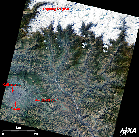
Figure 1 is an image of the Kathmandu Valley and its surroundings taken by ALOS (“Daichi”) in February 2009. Kathmandu, the capital of Nepal, is seen bluish-grey at the bottom left of the image. Kathmandu, about 1,300 meters above sea level, is located in a basin surrounded by mountains. Branches of the Ganges flow in the basin making fields in the basin suitable for cultivation. Three old towns, Kathmandu, Patan, and Bhaktapur, are located in the basin and each town has an old palace.
The northern border of Nepal is the Himalayas, including Mt. Everest and other 8,000-meter-class peaks. You can see part of the white Himalayas covered by snow and ice at the upper part of the image. Most climbers of the Himalayas approach from the Nepal side and set their base at Kathmandu. The Langtang Valley, a popular trekking course, is located 50 kilometers north of Kathmandu.
caption on
caption off
The Newar culture, a mixture of Hinduism and Buddhism, developed in the Kathmandu basin during the thirteenth and eighteenth centuries. Historic buildings remain in the three old cities shown in Figure 1. The Bagmati River, which flows between Kathmandu and Patan, is a branch of the Ganges.
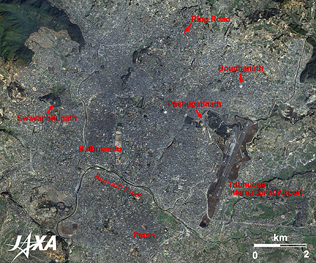
The three old towns and four temples of Hinduism and Buddhism were registered to the World Heritage List as the “Kathmandu Valley” in 1979. In Figure 2, you can see Swayambhunath, the oldest temple in Nepal, Pashupatinath, the biggest temple of Hinduism in Nepal, and Boudhanath, a temple of Tibetan Buddhism that has a 36-meter-high stupa.
The Kathmandu Valley was added to the List of World Heritage in Danger in 2003 because the valley was considered by UNESCO to be endangered by rapid urbanization and increasing environmental problems. You can see the 27-kilometer-long ring road around the city area constructed in the 1970s and Tribhuvan International Airport, which was expanded and its infrastructure improved in the second half of the 1980s. Since then, the Nepal government has made efforts to protect the historic heritage. Those efforts were recognized and the Kathmandu Valley was dropped from the List of World Heritage in Danger in 2007.
caption on
caption off
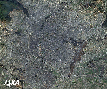
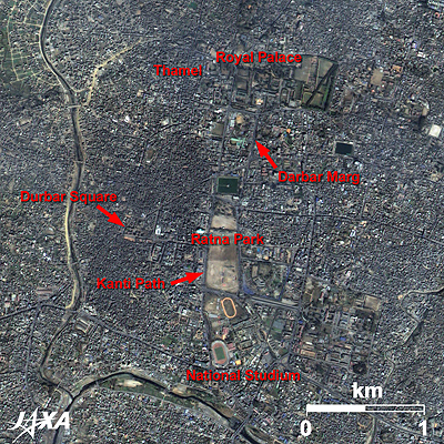
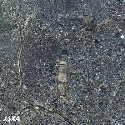
Fig. 3. Enlarged Image of Central Kathmandu
Kathmandu (kmz, 4.33 MB, Low Resolution) as seen on Google Earth
Figure 3 shows an enlarged image of central Kathmandu. There are parks and stadiums along the big street, Kanti Path, which runs from north to south in the middle of the image. At the north end you can see the present palace. On the west side of the street is the old town. Durbar Square sits in the center facing the old palace. The old areas are seen darker with crowded houses than the surrounding areas.
Around Durbar Marg street, which stretches to the south from the present palace, is a business area where high class hotels and restaurants stand. The Thamel area, which spreads southwest of the present palace, is a well-known tourist area with many souvenir shops.
Although, Kathmandu has problems with rapid urbanization and the environment, old buildings and temples remain in the old towns and are still admired by the people of Nepal.
Explanation of the Images:
| Satellite: | Advanced Land Observing Satellite (ALOS) (Daichi) |
| Sensor: |
Advanced Visible and Near Infrared Radiometer-2 (AVNIR-2) and Panchromatic Remote-sensing Instrument for Stereo Mapping (PRISM) |
| Date: | 0505 (UTC) on February 27, 2009 |
| Ground resolution: | 10 m (AVNIR-2) and 2.5 m (PRISM) |
| Map Projection: | Universal Transversal Mercator (UTM) |
AVNIR-2 has four observation bands. The color composite images are usually produced by assigning red to Band 3 (610 to 690 nm), green to Band 2 (520 to 600 nm) and blue to Band 1 (420 to 500 nm). The resulting images have natural coloring as if seen by the naked eye. Each color indicates the following ground objects:
| Dark Green: | Forests |
| Bright Green: | Farmlands, or grass fields |
| Light bluish-grey: | Urban areas |
| Brown: | Bare lands |
| White: | Roads, buildings, snow, or clouds |
PRISM is an optical sensor for observing ground surfaces with visible and near-infrared signals in the 520- to 770-nanometer (one-billionth of a meter) band. The image is monochromatic but has a higher resolution. PRISM has three independent optical systems to acquire images in the view of nadir, forward, and backward simultaneously. Only the nadir images are used in these figures.
The above AVNIR-2 color composite image is decomposed into, hue, saturation, and intensity. The intensity portion is replaced by PRISM data. The hue, saturation, and intensity data are then reversed into a color image. This color image has a virtual 2.5-m resolution. A color image composed by combining a higher resolution monochromatic image and a lower resolution color image is called a pan-sharpened image.
Lhasa, Tibet: The Center of Tibetan Culture and Buddhism
Eight-thousand-meter peak and Glaciers: Shishapangma, Himalayas
Search by Year
Search by Categories


Tags
-
#Earthquake
-
#Land
-
#Satellite Data
-
#Aerosol
-
#Public Health
-
#GCOM-C
-
#Sea
-
#Atmosphere
-
#Ice
-
#Today's Earth
-
#Flood
-
#Water Cycle
-
#AW3D
-
#G-Portal
-
#EarthCARE
-
#Volcano
-
#Agriculture
-
#Himawari
-
#GHG
-
#GPM
-
#GOSAT
-
#Simulation
-
#GCOM-W
-
#Drought
-
#Fire
-
#Forest
-
#Cooperation
-
#Precipitation
-
#Typhoon
-
#DPR
-
#NEXRA
-
#ALOS
-
#GSMaP
-
#Climate Change
-
#Carbon Cycle
-
#API
-
#Humanities Sociology
-
#AMSR
-
#Land Use Land Cover
-
#Environmental issues
-
#Quick Report
-
#GOSAT-GW
Related Resources


Related Tags
Latest Observation Related Articles
-
 Latest Observation 2026.06.05 Fri [Quick Report] Typhoon No. 6, “JANGMI”, brought heavy rain to Japan. – Results of satellite data analysis –
 -
 Latest Observation 2026.04.16 Thu [Quick Report] EarthCARE Captured the Eye of Typhoon Sinlaku
 -
 Latest Observation 2025.12.03 Wed [Quick Report] Analysis results from satellite precipitation data on the record-breaking heavy rainfall occurring in Southeast Asia in late November 2025
 -
 Latest Observation 2025.10.01 Wed [Quick Report] Hurricane Humberto “Eye” captured by EarthCARE satellite (Hakuryu)
Stay Connected
