


Latest Observation
2009.11.25 Wed
The Dead Sea: A Salt Lake 400 Meters Below Sea Level and the Land of the Bible
caption on
caption off
Dead Sea as seen on Google Earth (kmz format, 5.87 MB low resolution)
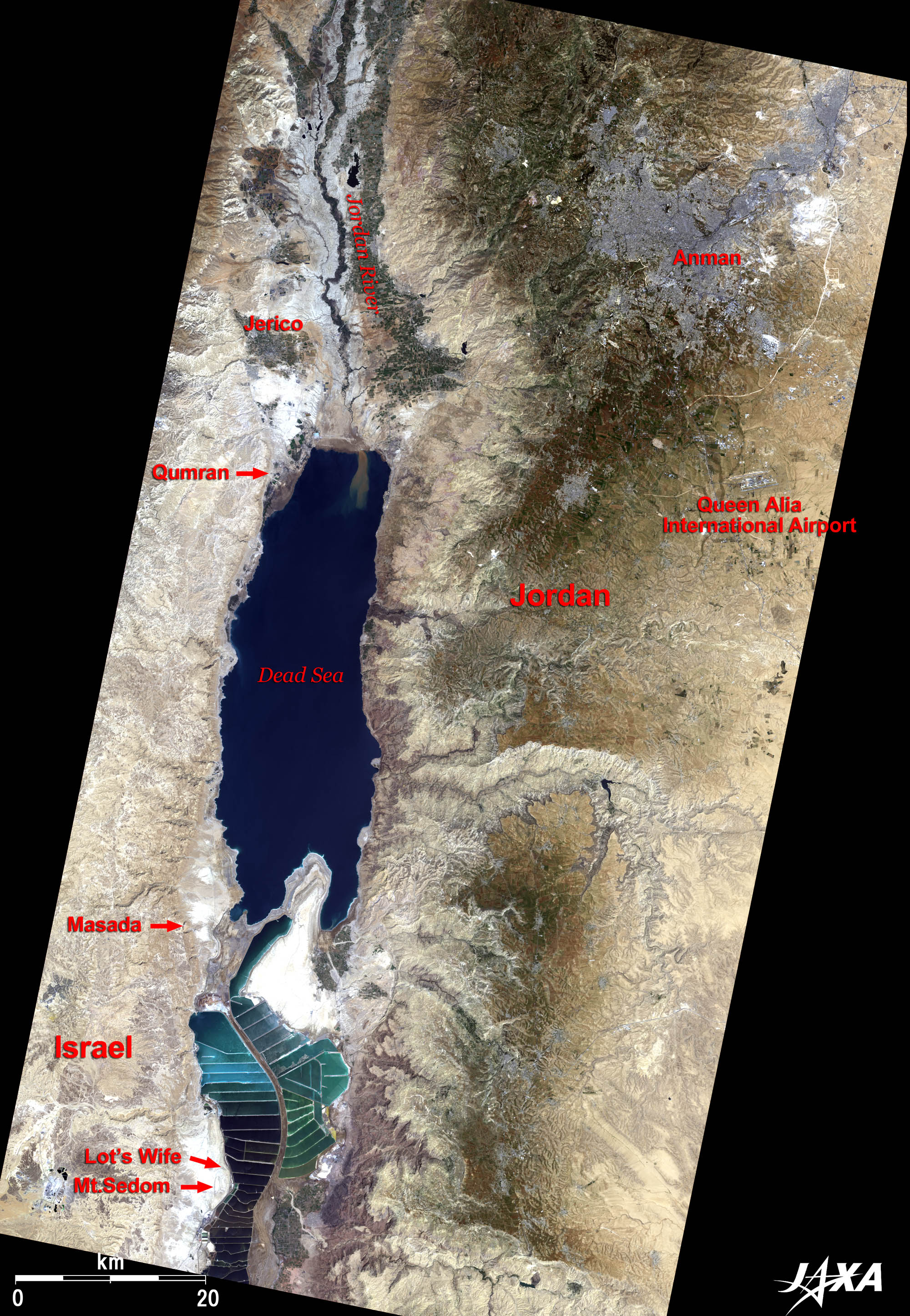
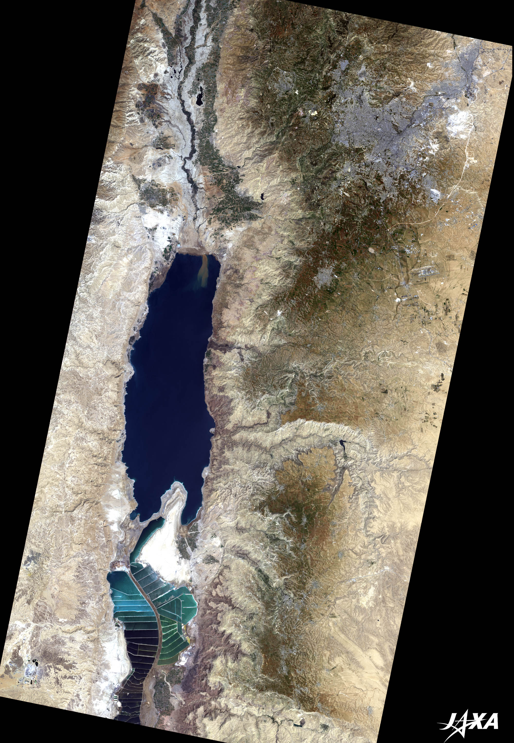
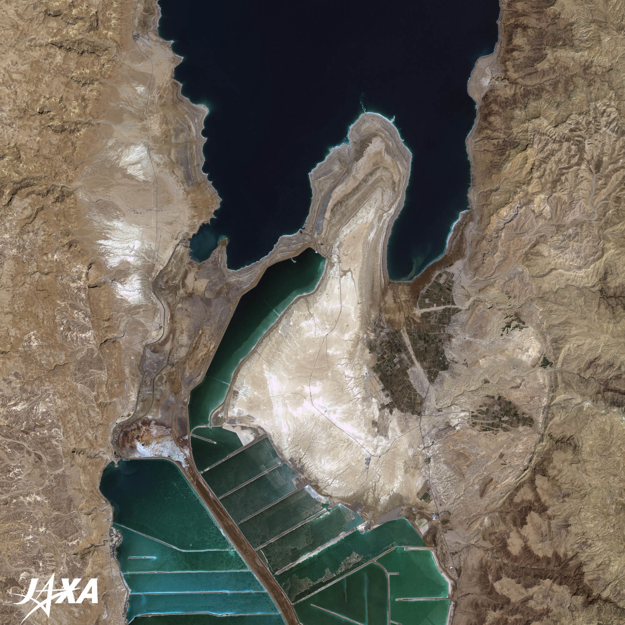
Figure 1 depicts the Dead Sea and its vicinity as observed by ALOS (“Daichi”) in April 2009. The dark blue portion in the center of the image is the Dead Sea. It is located at the northernmost end of the Great Rift Valley of eastern Africa, which runs from Tanzania through Ethiopia, the Red Sea, the Sinai Peninsula, and the Jordan Rift Valley. It is 810 km2 wide and 378 meters at its deepest point. It faces Jordan to the east and Israel to the west. The surface lies 422 meters below sea level making it the lowest lake in the world. The image reveals steep rocky terrain on both sides of the lake and the Jordan River flowing from the north, which deposits muddy water into the estuary, making it a turbid brown. There is, however, no outflow of water from the Dead Sea and the salt concentration is, consequently, as much as 30 percent while that of seawater is about 3 percent. People can read a newspaper while floating on the water without any effort. Cosmetics, etc., are also produced here by using the minerals contained in the lake.
A bluish gray area at the upper right of the image is Amman, the capital of Jordan. One can reach the Dead Sea from Amman through Jericho at the northern coast or from Jerusalem, the capital of Israel (20 km west of the Dead Sea and not included in this image), at the southernmost coast.
Jericho: The City of Palm Trees
At an altitude of 240 meters below sea level, Jericho is the lowest permanently inhabited town on Earth. Date palms, bananas, and oranges are grown here. It is also one of the oldest cities in the world and is surrounded by walls. The Hebrew Bible (the Book of Joshua) describes the famous “Battle of Jericho” where “the wall collapsed after Joshua’s army marched around the city and blew their trumpets.” There is also evidences of settlement dating back to 9,000 BC.
The Ein as-Sultan spring in town has been used since ancient times. It is also known as “Elisha’s Spring” since the Hebrew Bible also mentions that around 850 BC the prophet Elisha healed the poor spring of water by casting salt into it, thus showing the power of God.
The “Mount of Temptation,” where the devil tempted Jesus Christ, and Qumran, where the Dead Sea Scrolls were found, are also nearby.
The Dead Sea Scrolls
The Dead Sea scrolls consist of about 900 duplicated documents, including texts from the Hebrew Bible, discovered between 1947 and 1956 in eleven caves in and around the Qumran Wadi near the ruins of the ancient settlement of Khirbet Qumran on the northwest shore of the Dead Sea. They were written in Hebrew, Aramaic (Semitic language spoken by Jesus and Maria), and Greek, mostly on parchment and one copper plate. These manuscripts generally date between 150 BC and 70 AD. Amazingly, the contents are basically consistent with the current Bible and have been translated into various languages.

caption on
caption off
caption on
caption off
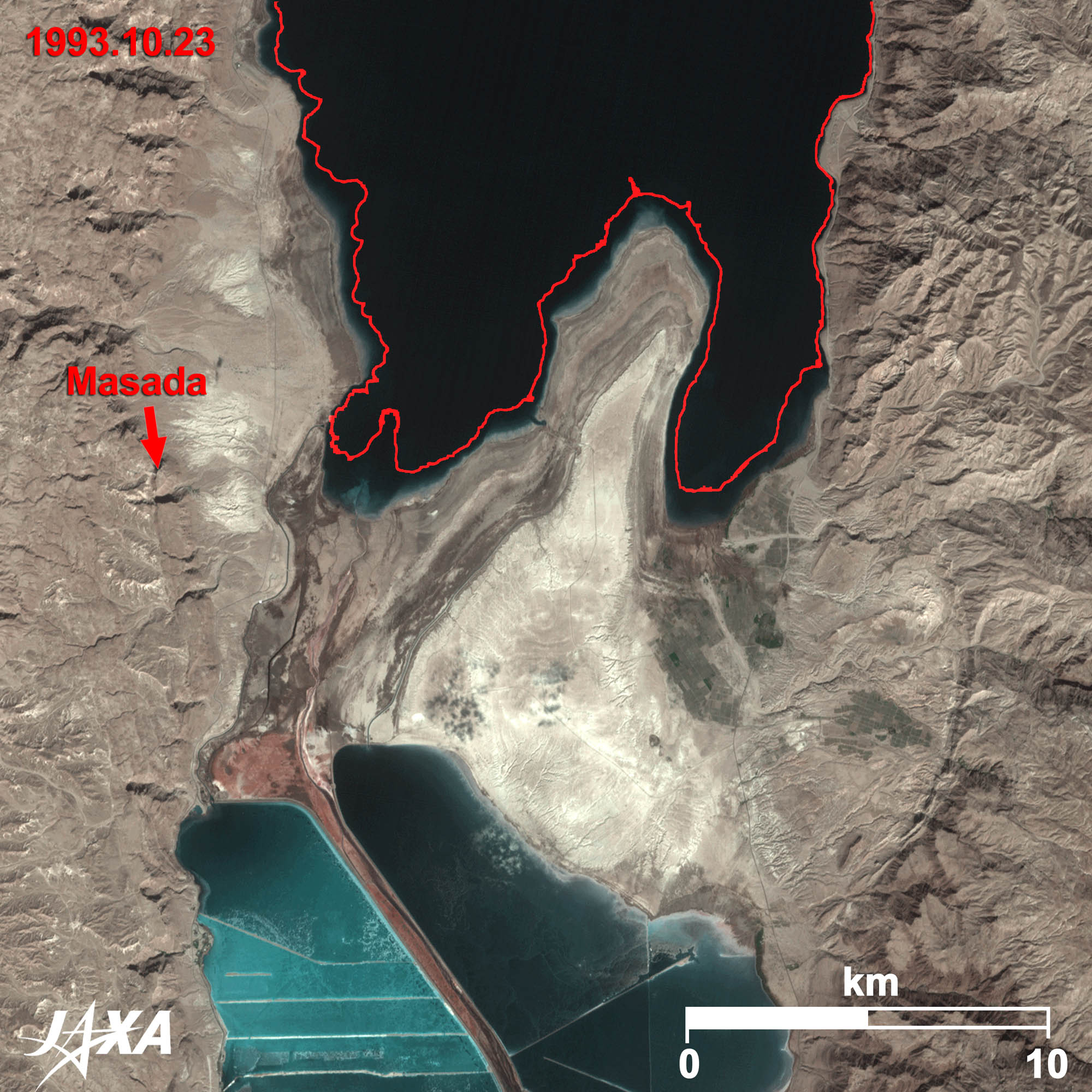
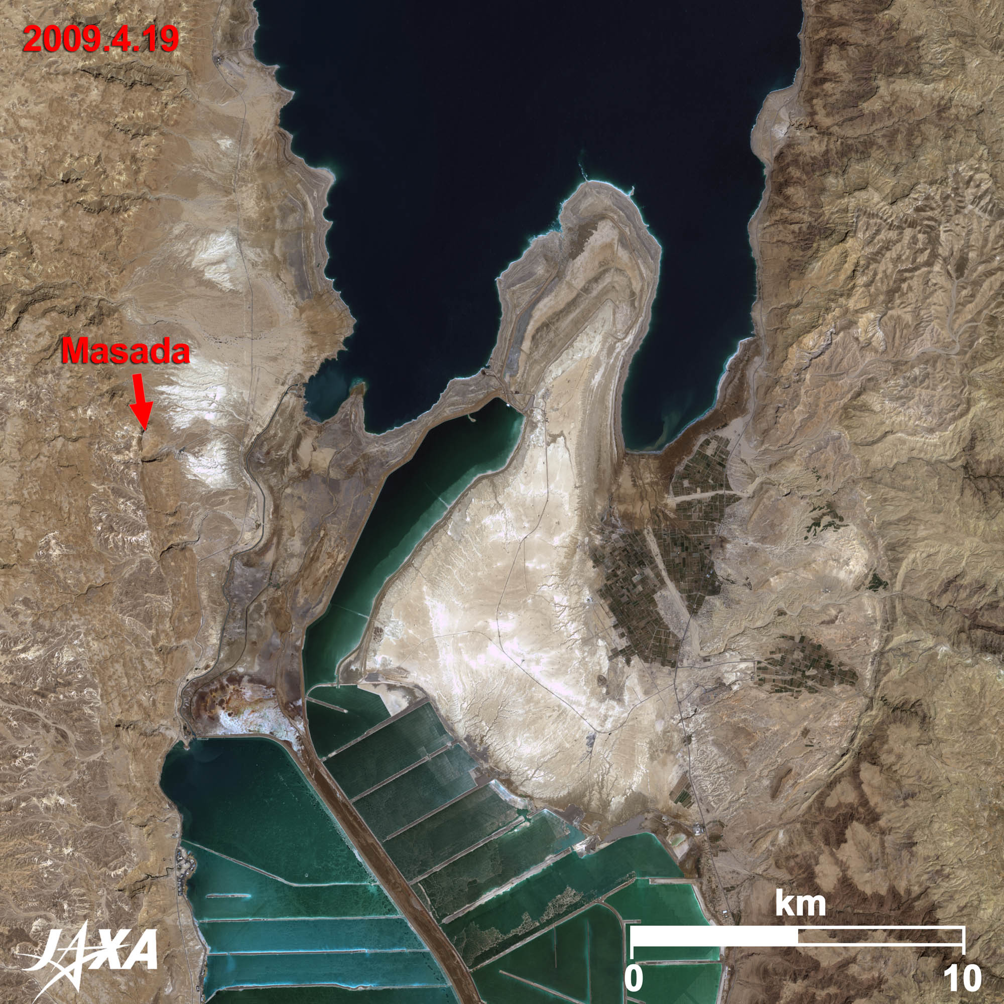
Fig. 2. Changes in the Southern Dead Sea over 16 Years
The left image of Figure 2 was observed by JERS-1 (“Fuyo”) 16 years ago. Compared with the right image, reduction of the Dead Sea is obvious as shown by the red line representing the present coast. The present waterfront line has retreated about 500 meters into the offing. Altitude of the water surface in 1993 was 407 meters below sea level and it decreases 1 meter every year.
Water level decreases of the Dead Sea, which pose an environmental problem for the area, may be due to the use of irrigation water from the Jordan River and to development of the canal in the south. Therefore, neighboring countries are planning to pour water from the Red Sea into the Dead Sea after it has been used in power generation and desalination plants.
The bottom part (south) of the image was once a part of the Dead Sea. The lowering water level has divided the Dead Sea into the north part and the south part. The shallow south part is now partitioned by embankments and the water of the Dead Sea is led here to produce potassium chloride. Masada (“fortress”), visible on the lower left of the image, is the final battlefield of the first Jewish-Roman War (66–73 AD; the rebellion by the Jews against the Roman Empire). After the fall of Jerusalem, 976 Jews took refuge in Masada and raided and harassed the siege of 15,000 Roman troops for 2 years. Finally in 73 AD, the 967 defenders all committed suicide, preferring death to defeat (two women and five children survived), and thus the war ended. Masada was registered to the list of the World Heritage of UNESCO for its cultural value in 2001.
Sodom and Gomorrah
Sodom and Gomorrah appear in Genesis as towns destroyed with fire and brimstone by God. As legend goes, the ruins were submerged to the bottom of the lake. Genesis tells of God deciding to save a righteous man, Lot, and his family (his wife and two daughters) before he destroyed the town and commanded Lot to leave town immediately and not to look back under any circumstances. However, as Sodom and Gomorrah were destroyed, Lot’s wife looked back longingly at the town and became a pillar of salt. There is still a pillar of salt, said to be Lot’s wife, in the mountain of rock salt at the southwest coast of the Dead Sea.
Explanation of the Images:
(Click the imaged twice to enlarge)
| Satellite: | Advanced Land Observing Satellite (ALOS) (Daichi) |
| Sensor: | Advanced Visible and Near Infrared Radiometer-2 (AVNIR-2)(Fig. 1 and right image of Fig. 2) |
| Date: | 0828 (UTC) on April 19, 2009 |
| Ground resolution: | 10 m |
| Map Projection: | Universal Transversal Mercator (UTM) |
AVNIR-2 has four observation bands. The composite images are usually produced by assigning red to Band 3 (610 to 690 nm), green to Band 2 (520 to 600 nm), and blue to Band 1 (420 to 500 nm). The resulting images have natural coloring as if seen by the naked eye. The following colors designate ground objects:
| Dark Green: | Fruit farm |
| Bluish grey: | City area |
| Blue: | Water surfaces |
| Brown: | Rocks or soil |
| Grey: | Sands, salt, or buildings |
| Satellite: | Japanese Earth Resources Satellite-1 (JERS-1) (Fuyo-1) |
| Sensor: | Visible and Near Infrared Radiometer (VNIR) |
| Date: | 0832 (UTC) on October 23, 1993 (Left image of Fig. 2) |
| Ground resolution: | 18.3 m x 24.2 m |
| Map Projection: | Universal Transversal Mercator (UTM) |
The composite images are usually produced by assigning red to Band 2 (630 to 690nm), green to Band 3 (760 to 860nm; near infrared), and blue to Band 1 (520 to 600nm). In the above images, green is assigned to the sum of 90 percent of Band 2 and 10 percent of Band 3. The resulting image has natural coloring as if seen by the naked eye.
Related Sites
Search by Year
Search by Categories


Tags
-
#Earthquake
-
#Land
-
#Satellite Data
-
#Aerosol
-
#Public Health
-
#GCOM-C
-
#Sea
-
#Atmosphere
-
#Ice
-
#Today's Earth
-
#Flood
-
#Water Cycle
-
#AW3D
-
#G-Portal
-
#EarthCARE
-
#Volcano
-
#Agriculture
-
#Himawari
-
#GHG
-
#GPM
-
#GOSAT
-
#Simulation
-
#GCOM-W
-
#Drought
-
#Fire
-
#Forest
-
#Cooperation
-
#Precipitation
-
#Typhoon
-
#DPR
-
#NEXRA
-
#ALOS
-
#GSMaP
-
#Climate Change
-
#Carbon Cycle
-
#API
-
#Humanities Sociology
-
#AMSR
-
#Land Use Land Cover
-
#Environmental issues
-
#Quick Report
-
#GOSAT-GW
Related Resources


Related Tags
Latest Observation Related Articles
-
 Latest Observation 2026.06.05 Fri [Quick Report] Typhoon No. 6, “JANGMI”, brought heavy rain to Japan. – Results of satellite data analysis –
 -
 Latest Observation 2026.04.16 Thu [Quick Report] EarthCARE Captured the Eye of Typhoon Sinlaku
 -
 Latest Observation 2025.12.03 Wed [Quick Report] Analysis results from satellite precipitation data on the record-breaking heavy rainfall occurring in Southeast Asia in late November 2025
 -
 Latest Observation 2025.10.01 Wed [Quick Report] Hurricane Humberto “Eye” captured by EarthCARE satellite (Hakuryu)
Stay Connected
