


Latest Observation
2009.11.18 Wed
New Airports in Asia
Aiming to assume the role of a hub airport in Asia, new airports in Malaysia, Hong Kong, South Korea, and Thailand opened around the year 2000. They are respectively,
Kuala Lumpur International Airport (opened on June 30, 1998),
Hong Kong International Airport (opened on July 6, 1998),
Incheon International Airport (opened on March 29, 2001),
Suvarnabhumi International Airport (opened on September 28, 2006).
caption on
caption off
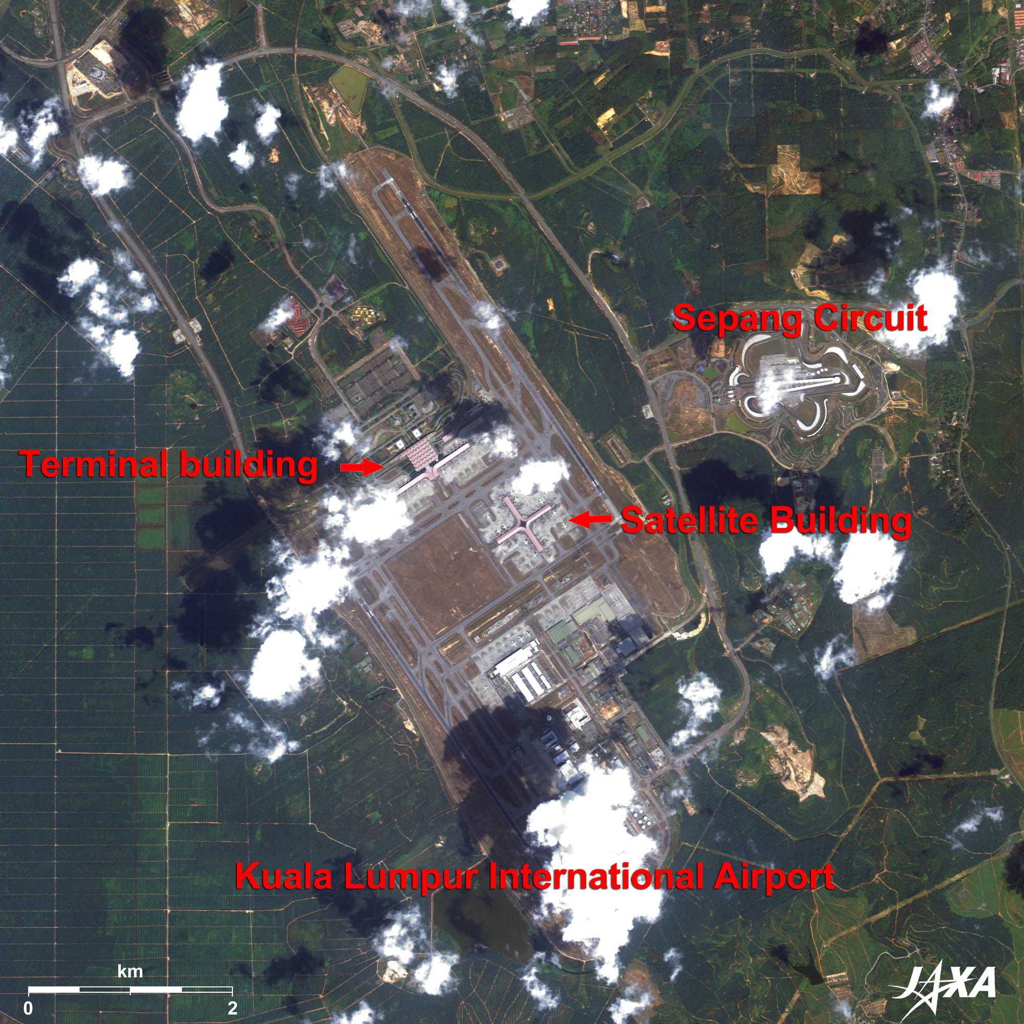
Kuala Lumpur International Airport as seen on Google Earth (kmz format, 4.00 MB low resolution)
Figure 1 is an image of Kuala Lumpur International Airport in Malaysia as observed by ALOS (Daichi) in January 2009. This airport is located about 50 km south of the city center and is the second largest in the world next to Denver International Airport in the United States. The total area is about 100 km2, which is ten times larger than that of Narita International Airport in Japan. Two 4,000-meter-long runways are visible on both sides of the airport terminal. Upon its completion, the airport will have five runways and two large terminals. Connections to the city center can be made via a 30-minute train ride. Mr. Kisho Kurokawa (a famous Japanese architect) was engaged in the grand design of the airport, which employed state of the art architectural engineering and ergonomics.

caption on
caption off
Fig. 2. Hong Kong International Airport
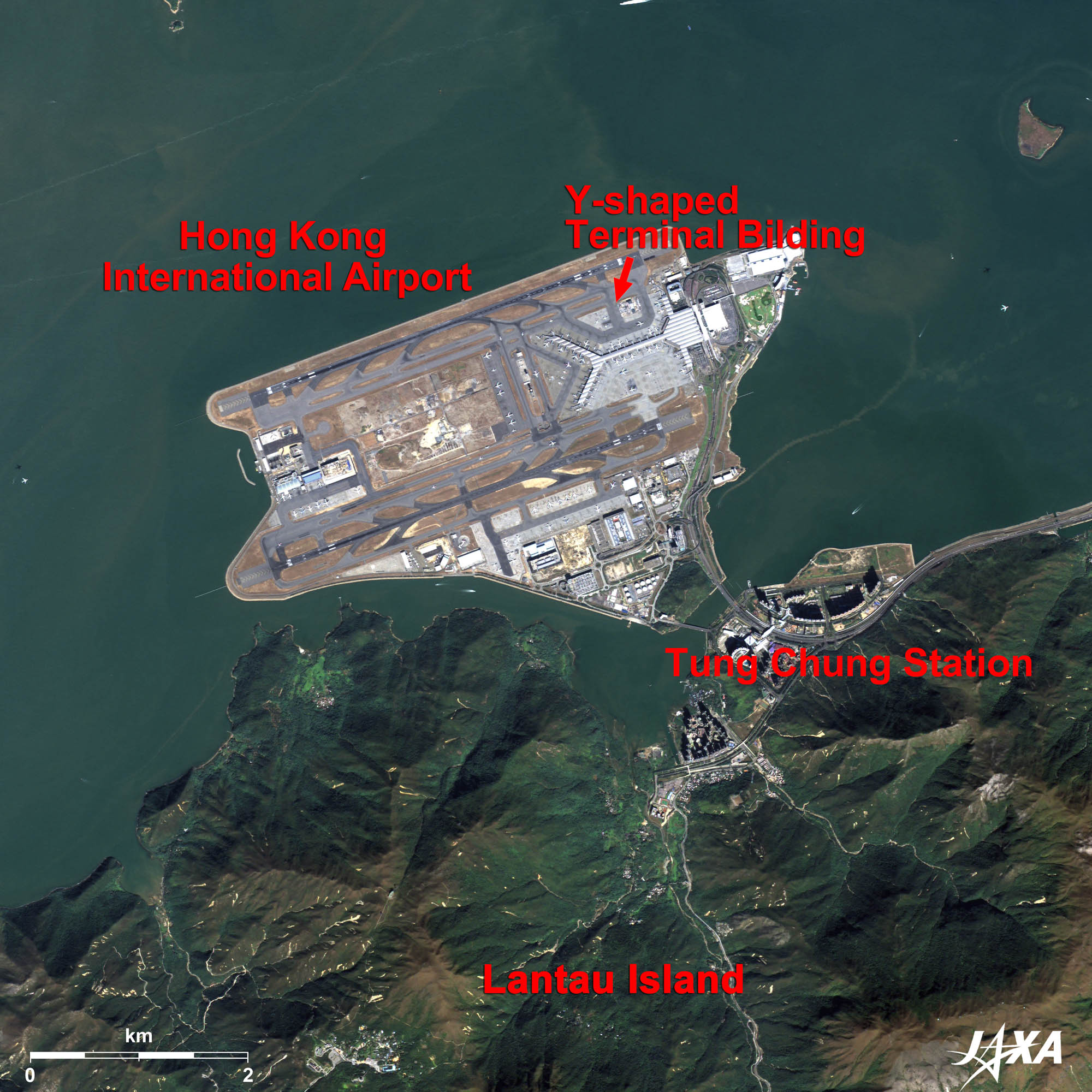
Hong Kong International Airport (kmz, 3.55 MB, Low Resolution) as seen on Google Earth
Figure 2 shows Hong Kong International Airport as observed in November 2008. It has a unique Y-shaped airport terminal building. The former Kai Tak International Airport was located in the Kowloon Peninsula, very close to downtown Hong Kong. It was the bane of pilots since they had to buzz building tops during their approach phase for landing. Since Hong Kong was to be returned to China from Britain on July 1, 1997, the governor of Hong Kong decided to construct a new airport in 1989. An island off Lantau Island at the west of Kowloon Peninsula was ground down and reclaimed and the new airport opened in July 1998, a week after Kuala Lumpur International Airport opened. There were troubles due to computer systems malfunctions and operational errors at the beginning, but they have since been fixed.
The total area is 12.48 km2 and it has two 3,800-meter-long runways. The airport connects to Hong Kong Station in 24 minutes by a high-speed train that is free of charge for passengers.
caption on
caption off
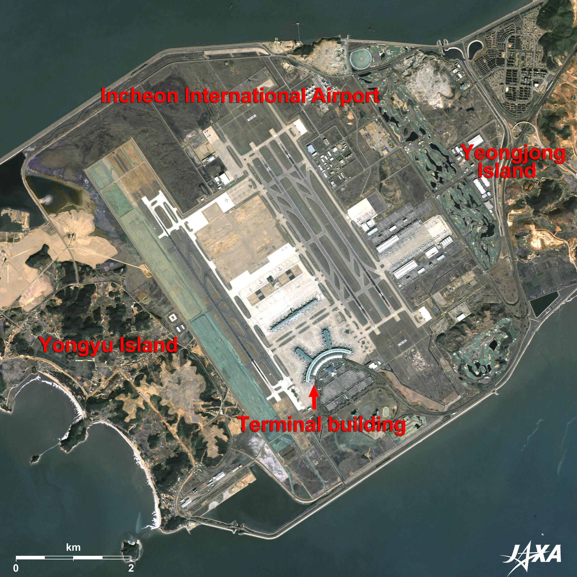
Incheon International Airport (kmz, 4.01 MB, Low Resolution) as seen on Google Earth
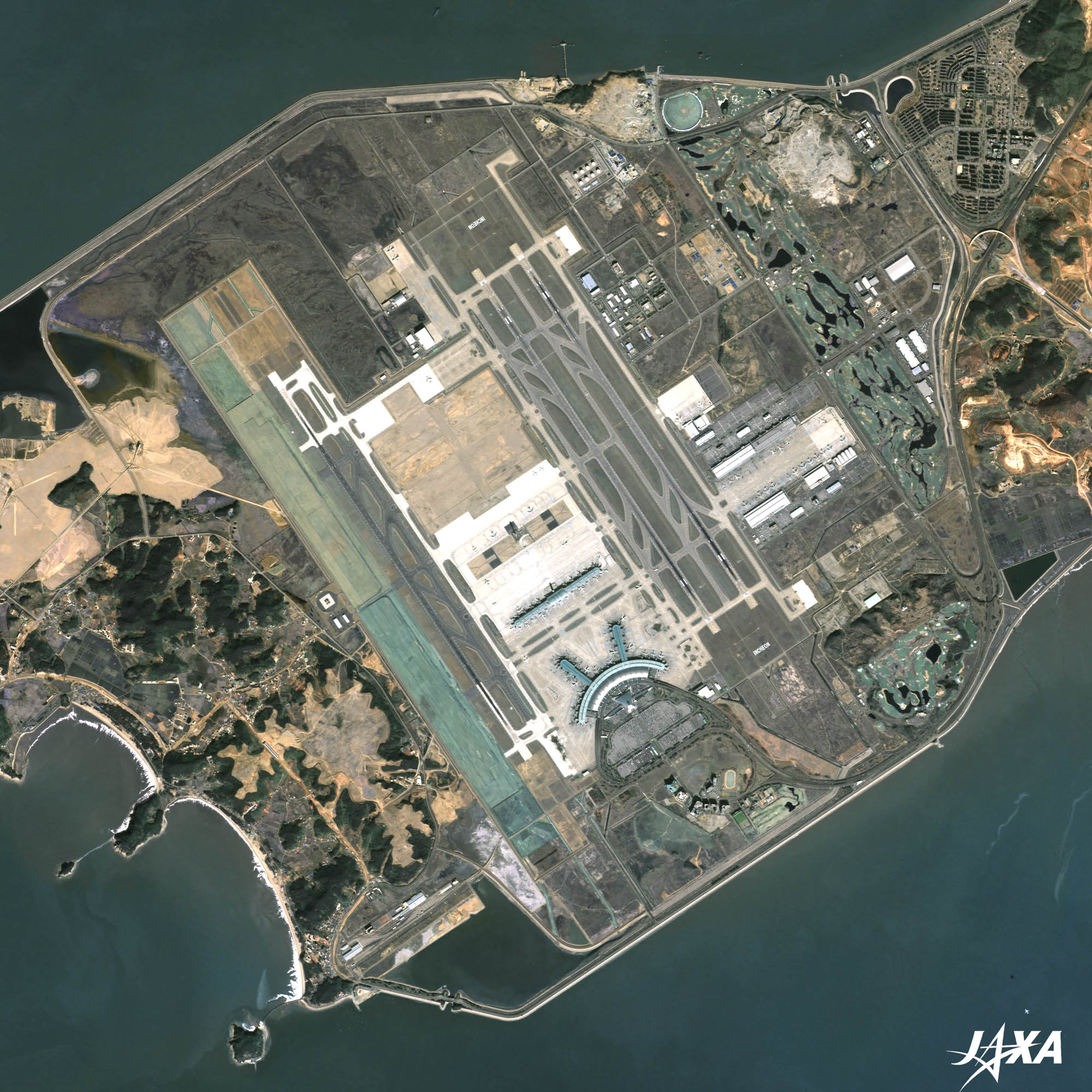
Figure 3 is an image of Incheon International Airport as observed in May 2009. It is located about 50 km west of Seoul. The airport was constructed on reclaimed land over the tidal flat joining two islands off Incheon City. On both sides of the image, edges of the two islands, Yeongjong Island and Yongyu Island, can be seen. The airport is shaped like the sail of a large vessel and occupies 11.7 km2. Two runways in the east and one runway in the west are visible, and further expansion is expected. It connects to downtown Incheon by airport limousine in 60 minutes. The train service to Gimpo International Airport, which opened in March 2007, is also available and takes about 30 minutes. This train route will extend as far as Seoul in 2010.
In addition to the three runways currently in operation, another runway of the same size, visible as green in the image, will be constructed on the land adjoining the runway in the west. A golf course on the east side will also become a runway in the future.
caption on
caption off
Suvarnabhumi International Airport (kmz, 4.41 MB, Low Resolution) as seen on Google Earth
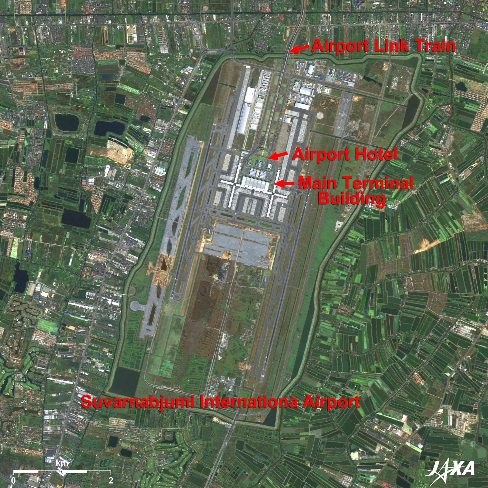
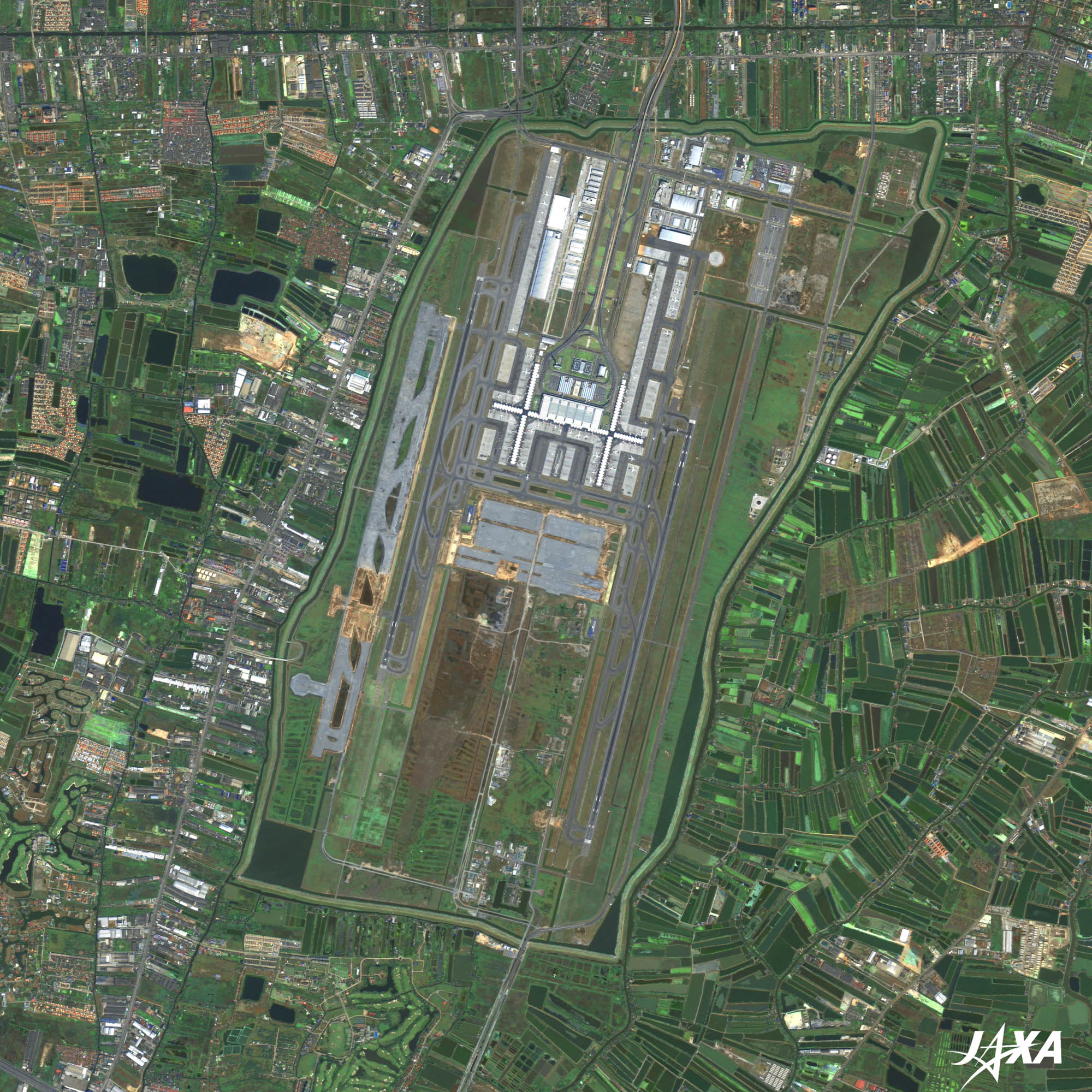
igure 4 shows Suvarnabhumi International Airport as observed in December 2006. It is the most recently opened airport located about 30 km east of Bangkok. The total area is 32 km2, which makes it three times larger than Narita. A 4,000-meter-long runway east of the terminal building and a 3,700-meter-long runway west of it are visible in the image. According to the airport plan, two additional runways will be built in the future. Busses and taxies are used to access the city center and the Suvarnabhumi Airport Link (Express) train is under construction. It was expected to open in 2008, but was delayed due to cracks in the supporting pillars of the elevated railroad as well as a land acquisition delay. It was opened for limited trials on December 5, 2009 (the birthday of Phumiphon Adunyadet, the King of Thailand) and expected for full service in early 2010.
Satellite imagery shows the efforts of these countries to construct new airports that serve as the core infrastructure in Asia, that support their economic development, and that help them obtain leadership in these areas.
ALOS (Daichi) images are used in the background images of the JAL_MAP.
Explanation of the Images:
(Click the imaged twice to enlarge)
| Satellite: | Advanced Land Observing Satellite (ALOS) (Daichi) |
| Sensor: |
Advanced Visible and Near Infrared Radiometer-2 (AVNIR-2) and Panchromatic Remote-Sensing Instrument for Stereo Mapping (PRISM) |
| Date: | 0345 (UTC) on January 22, 2009 (AVNIR-2 and PRISM) (Fig. 1) 0307 (UTC) on November 12, 2008 (AVNIR-2 and PRISM) (Fig. 2) 0231 (UTC) on May 19, 2009 (AVNIR-2) (Fig. 3) 0230 (UTC) on February 16, 2009 (PRISM) (Fig. 3) 0355 (UTC) on December 12, 2006 (AVNIR-2) (Fig. 4) 0355 (UTC) on October 30, 2007 (PRISM) (Fig. 4) |
| Ground resolution: | 10 m (AVNIR-2) and 2.5 m (PRISM) |
| Map Projection: | Universal Transversal Mercator (UTM) |
AVNIR-2 has four observation bands. The composite images are usually produced by assigning red to Band 3 (610 to 690 nm), green to Band 2 (520 to 600 nm), and blue to Band 1 (420 to 500 nm). The resulting images have natural coloring as if seen by the naked eye. The following colors designate ground objects:
| Dark Green: | Forests |
| Light green: | Farmlands or grass fields |
| Light grey: | City area |
| Blue: | Water surfaces |
| White: | Roads, bare land, or buildings |
PRISM is an optical sensor for observing ground surfaces with visible and near-infrared signals in the 520- to 770-nanometer (one-billionth of a meter) band. The acquired image is monochrome. PRISM has three independent optical systems (telescopes) to acquire images for nadir, forward, and backward views simultaneously. Only the nadir image was used in this article.
The above AVNIR-2 composite image was then transformed into hue, saturation, and intensity, and the intensity was replaced by the PRISM image. The hue, saturation, and intensity data were then reversed into a color image. As a result, a virtual 2.5-m ground resolution color image was obtained. This kind of high-resolution color image, composed by combining the higher resolution monochrome image and the lower resolution color image, is called a pan-sharpened image.
Hong Kong with Forests of Skyscrapers
With the Flow of Han River; Seoul, Republic of Korea
Bangkok: City of Angels 10 Years Later
Search by Year
Search by Categories


Tags
-
#Earthquake
-
#Land
-
#Satellite Data
-
#Aerosol
-
#Public Health
-
#GCOM-C
-
#Sea
-
#Atmosphere
-
#Ice
-
#Today's Earth
-
#Flood
-
#Water Cycle
-
#AW3D
-
#G-Portal
-
#EarthCARE
-
#Volcano
-
#Agriculture
-
#Himawari
-
#GHG
-
#GPM
-
#GOSAT
-
#Simulation
-
#GCOM-W
-
#Drought
-
#Fire
-
#Forest
-
#Cooperation
-
#Precipitation
-
#Typhoon
-
#DPR
-
#NEXRA
-
#ALOS
-
#GSMaP
-
#Climate Change
-
#Carbon Cycle
-
#API
-
#Humanities Sociology
-
#AMSR
-
#Land Use Land Cover
-
#Environmental issues
-
#Quick Report
-
#GOSAT-GW
Related Resources


Related Tags
Latest Observation Related Articles
-
 Latest Observation 2026.06.05 Fri [Quick Report] Typhoon No. 6, “JANGMI”, brought heavy rain to Japan. – Results of satellite data analysis –
 -
 Latest Observation 2026.04.16 Thu [Quick Report] EarthCARE Captured the Eye of Typhoon Sinlaku
 -
 Latest Observation 2025.12.03 Wed [Quick Report] Analysis results from satellite precipitation data on the record-breaking heavy rainfall occurring in Southeast Asia in late November 2025
 -
 Latest Observation 2025.10.01 Wed [Quick Report] Hurricane Humberto “Eye” captured by EarthCARE satellite (Hakuryu)
Stay Connected
