


Disaster
2025.10.23 Thu
ALOS-2 Observations of the Earthquakes in the Philippines
(Cebu Island and Mindanao Island)
On September 30, 2025, a magnitude 6.9 earthquake struck off the northern coast of Cebu Island, the Philippines. Subsequently, on October 10, a magnitude 7.4 earthquake occurred off the southern coast of Mindanao Island.
As the Secretariat of Sentinel Asia, JAXA conducted emergency observations by ALOS-2 in response to both events. This article introduces the actions taken for each earthquake.
September 30, 2025: Earthquake on Cebu Island
At 23:00 JST on September 30, an earthquake struck in the norther coast of Cebu Island. In response, the Philippine Institute of Volcanology and Seismology (PHIVOLCS) and the Mines and Geosciences Bureau (MGB) of the Department of Environment and Natural Resources, both are Sentinel Asia members, activated Sentinel Asia.
Once the activation was made, JAXA conducted an emergency observation using the ALOS-2 satellite and provided data and analysis results according to the following timeline (Table 1).
| Date | Time (JST) | Activity |
| Sep 30, 2025 | 23:00 | Earthquake occurred in northern Cebu Island |
| Oct 1, 2025 | 15:00 | Sentinel Asia was activated following requests from PHIVOLCS and MGB. JAXA began coordination for emergency observation by ALOS-2. |
| Oct 2, 2025 | 23:53 | ALOS-2 conducted an emergency observation. |
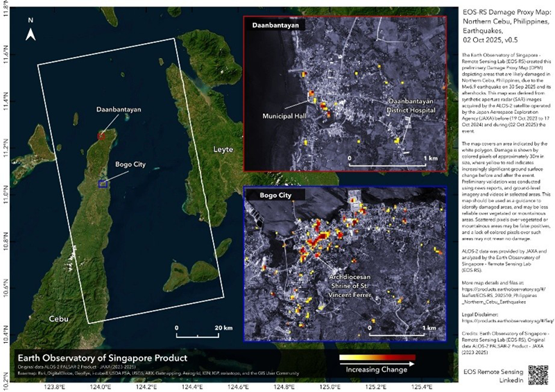
| Oct 3, 2025 | 15:00 | Damage Proxy Map (Figure 1) analyzed by the Earth Observatory of Singapore (EOS) was provided to Sentinel Asia. |
The timeline may vary depending on the factors such as available observation opportunities, the observation mode suitable for the disaster type, and the availability of pre-event imagery. In this case, the response was completed within approximately three days after the earthquake, allowing for timely information delivery.
Figure 1 shows the Damage Proxy Map generated by EOS using ALOS-2 data. Areas where surface changes were estimated between pre- and post-event images are shown in a color gradient from yellow to red. Regions in red indicate greater changes, implying a higher likelihood of damage to structures such as buildings, while yellow represents areas with smaller changes.

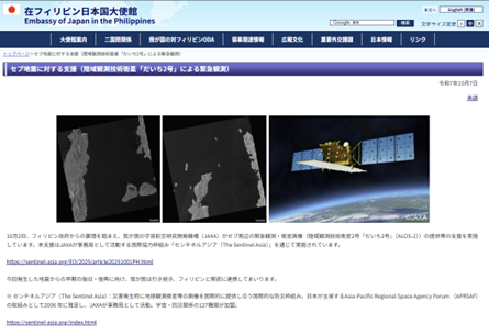
The Embassy of Japan in the Philippines also shared activities about this event on their website (Figure 2) on October 7, 2025.
October 10, 2025: Earthquake on Mindanao Island
At 9:45 JST on October 10,2025, a large earthquake occurred off the southern coast of Mindanao Island. In this event, PHIVOLCS sent an emergency request and Sentinel Asia was activated.
JAXA subsequently coordinated and conducted an emergency observation with ALOS-2 at 23:53 JST on October 16, 2025.
Through Sentinel Asia, JAXA will continue to deepen its cooperation with both domestic and international members to assist in disaster response and mitigation.
<What is Sentinel Asia?>
- Sentinel Asia is an international initiative aimed at supporting disaster management activities in the Asia-Pacific region through the utilization of space technology.
- Sentinel Asia is aiming to enhance mitigation from natural disasters by sharing disaster-related information such as Earth observation satellite data on the Internet.
- As of October 2025, there are 127 members from 30 countries including space agencies, research institutions, disaster prevention organizations.
<Related Links>
Sentinel Asia Website
Earthquake in Northern Cebu, Philippines on 01 October, 2025 (Sentinel Asia website)
Earthquake in coast of southeast Mindanao, Philippines on 10 October, 2025 (Sentinel Asia website)
Search by Year
Search by Categories


Tags
-
#Earthquake
-
#Land
-
#Satellite Data
-
#Aerosol
-
#Public Health
-
#GCOM-C
-
#Sea
-
#Atmosphere
-
#Ice
-
#Today's Earth
-
#Flood
-
#Water Cycle
-
#AW3D
-
#G-Portal
-
#EarthCARE
-
#Volcano
-
#Agriculture
-
#Himawari
-
#GHG
-
#GPM
-
#GOSAT
-
#Simulation
-
#GCOM-W
-
#Drought
-
#Fire
-
#Forest
-
#Cooperation
-
#Precipitation
-
#Typhoon
-
#DPR
-
#NEXRA
-
#ALOS
-
#GSMaP
-
#Climate Change
-
#Carbon Cycle
-
#API
-
#Humanities Sociology
-
#AMSR
-
#Land Use Land Cover
-
#Environmental issues
-
#Quick Report
-
#GOSAT-GW
Related Resources


Related Tags
Disaster Related Articles
-
 Disaster 2025.04.04 Fri ALOS-2 Observation of the M7.7 Earthquake in Myanmar
 -
 Disaster 2024.09.09 Mon ALOS-2 Observation of the Oil Spill Caused by the Sinking of a Tanker in Manila Bay, Philippines
 -
 Disaster 2023.04.07 Fri ALOS-2 observation: Oil spill from sunken oil tanker off Mindoro Island, Philippines (follow-up report)
 -
 Disaster 2023.03.31 Fri ALOS-2 observation: Oil spill from sunken oil tanker off Mindoro Island, Philippines
Stay Connected
