


Applications
2023.08.04 Fri
Contribution to SDGs Goal 6 “Clean Water and Sanitation”
SDGs Goal 6 “Clean Water and Sanitation” aims to ensure availability and sustainable management of water and sanitation for all, and this goal includes 8 targets. While many of them are about drinking water or sanitation, Target 6.6.1 has been set and focuses on water-related ecosystems and states “By 2020, protect and restore water-related ecosystems, including mountains, forests, wetlands, rivers, aquifers and lakes”.
An indicator that measures progress on this target is “Change in the extent of water-related ecosystems over time” (Indicator 6.6.1). Since the indicator covers very wide areas of water-related ecosystems, it is divided into 5 subcategories that are 1) vegetated wetlands, 2) rivers and estuaries, 3) lakes, 4) aquifers, and 5) artificial waterbodies. Among them, “vegetated wetlands” includes swamps, fens, peatlands, marshes, paddies, and mangroves.
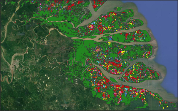
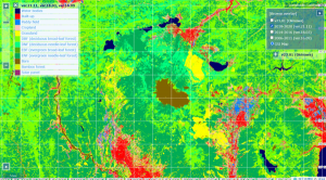
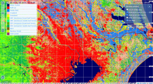
On the other hand, JAXA has been aware of the importance of monitoring mangroves by satellite since before the SDGs and has been working to prevent the loss and degradation of mangrove forests. This initiative, called “K&C Global Mangrove Watch (GMW) ”, began mapping the status and changes of mangroves around the world in 2011.
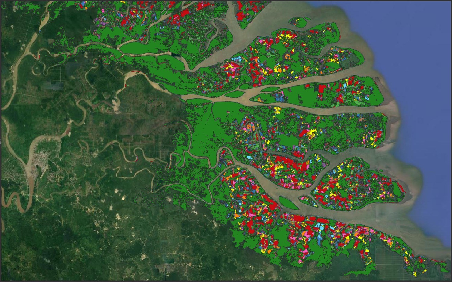
GMW mapped the extent of mangroves back in 1996 with the observation data obtained by the Synthetic Aperture Radar (SAR) on satellites such as JAXA’s Advanced Land Observing Satellite “DAICHI-2” (ALOS-2), and has been providing to the Ramsar Convention Secretariat and other relevant agencies. Tropical and subtropical areas where mangroves grow are often covered with clouds, and optical satellites may not obtain sufficient data. However, SAR satellites allow us to obtain data on the ground surface regardless of weather conditions and GMW updates the map every year.
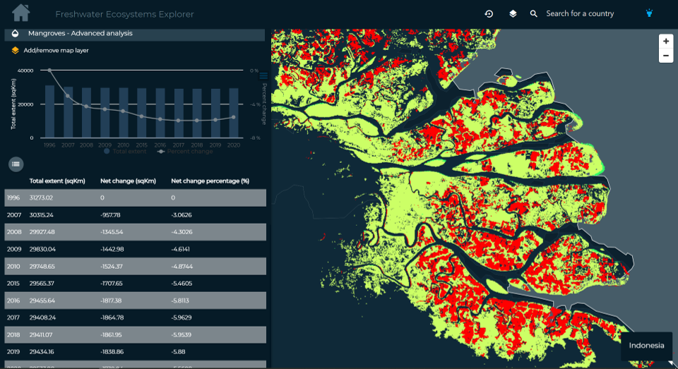
The United Nations Environment Programme (UNEP), the custodian agency of Target 6.6, has turned its attention to JAXA’s GMW and has officially decided that the data will be used to extract information for Indicator 6.6.1 in 2019. As GMW data has been available for free of charge, UNEP developed and published a methodology document describing how to use the data in 2020, which allowed countries to calculate changes in their mangrove area on their own.
In addition, UNEP developed and released the “Freshwater Ecosystems Explorer” in 2020, which allows users to obtain geospatial information on water-related ecosystems covered by Indicator 6.6.1 using a web browser. Currently, anyone can easily see on the map of the Explorer where and to what extent mangroves around the world are increasing or decreasing.
1 One of the activities under “Kyoto & Carbon Initiative”, an international collaborative research project led by JAXA.
Search by Year
Search by Categories


Tags
-
#Earthquake
-
#Land
-
#Satellite Data
-
#Aerosol
-
#Public Health
-
#GCOM-C
-
#Sea
-
#Atmosphere
-
#Ice
-
#Today's Earth
-
#Flood
-
#Water Cycle
-
#AW3D
-
#G-Portal
-
#EarthCARE
-
#Volcano
-
#Agriculture
-
#Himawari
-
#GHG
-
#GPM
-
#GOSAT
-
#Simulation
-
#GCOM-W
-
#Drought
-
#Fire
-
#Forest
-
#Cooperation
-
#Precipitation
-
#Typhoon
-
#DPR
-
#NEXRA
-
#ALOS
-
#GSMaP
-
#Climate Change
-
#Carbon Cycle
-
#API
-
#Humanities Sociology
-
#AMSR
-
#Land Use Land Cover
-
#Environmental issues
-
#Quick Report
-
#GOSAT-GW
Related Resources


Related Tags
Applications Related Articles
-
 Applications 2024.01.15 Mon The Use of Earth Observation Satellite Data in the Humanities and Social Sciences (2)
 -
 Applications 2023.11.29 Wed The Use of Earth Observation Satellite Data in the Humanities and Social Sciences (1)
 -
 Applications 2023.07.10 Mon Contribution to SDGs Goal 15 “Life on Land”
 -
 Applications 2023.06.15 Thu Contribution to SDGs Goal 11 “Sustainable cities and communities”
Stay Connected
