


Disaster
2022.07.13 Wed
Observation of record-breaking heavy rainfall in Saitama Prefecture
Record-breaking heavy rainfall centered on Saitama Prefecture on the night of July 12, 2022, caused damage such as flooded roads and landslides. From the perspective of providing information on precipitation condition, JAXA conducted the analysis using data from the Global Precipitation Measurement (GPM) core observatory, which observes rainfall conditions from space.
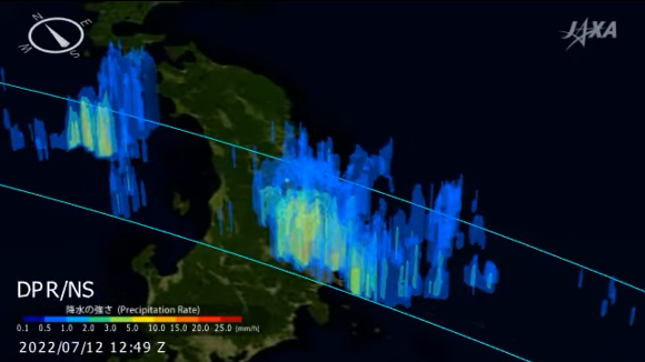
Figure 1 shows the distribution of heavy rainfall observed by the Dual-frequency Precipitation Radar (DPR) developed by Japan onboard the GPM core observatory. Localized excessive rains have been observed mainly in northern Saitama Prefecture, and precipitation amounts of nearly 100 mm/h have been observed by satellite around Kawagoe.
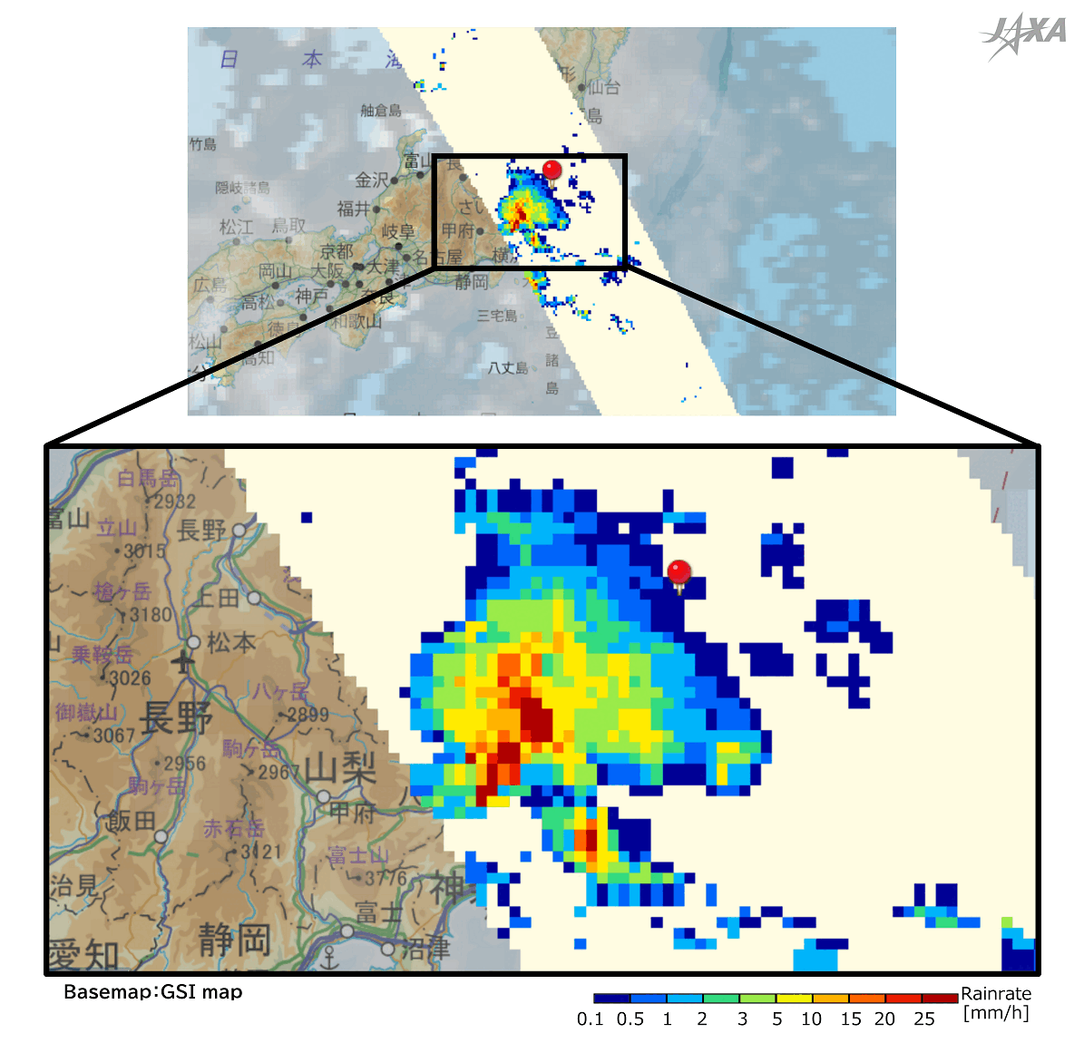
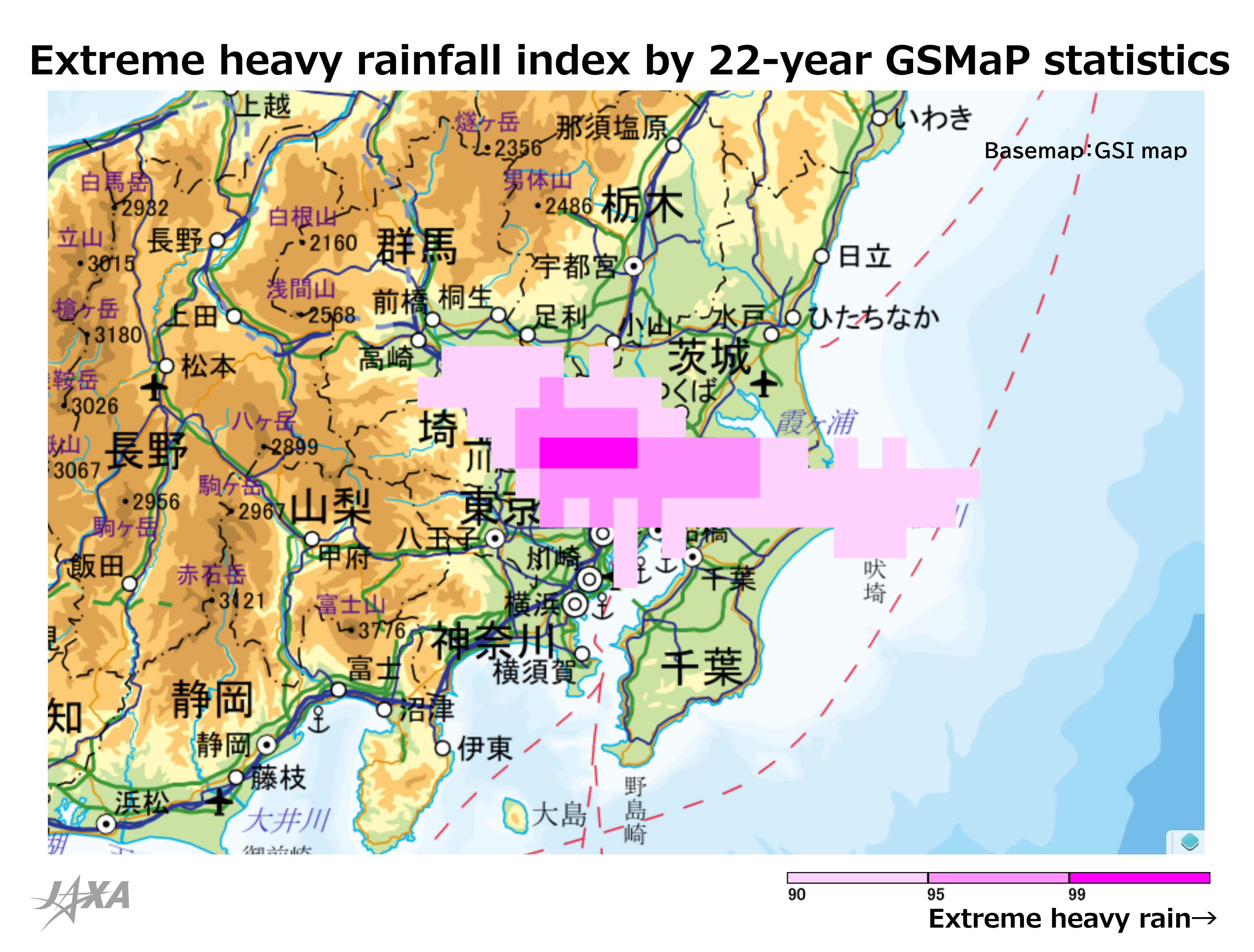
Figure 2 shows the extreme heavy rainfall index from 09:00 on July 12, 2022 to 08:59 the next day (JST) calculated from the statistical data of “Global Satellite Mapping of Precipitation (GSMaP)”, which was developed from multiple satellites that observe precipitation, including the GPM core observatory. The pink area indicates how extreme the rainfall was during the period of 24 hours from 09:00 on July 12 to 08:59 the next day in 2022 (JST) comparing with the mean precipitation of 24 hours in the past 22 years. We can find that there was heavy rainfall in the dark pink area around Kawagoe with a rare frequency of occurrence based on historical statistics.
The moving image in Figure 3 shows the observation result of three-dimensional structure of the heavy rainfall that occurred in Saitama shown in Figure 1. In the area of localized precipitation shown in red, rain clouds were observed to have developed up to 10 km in height.
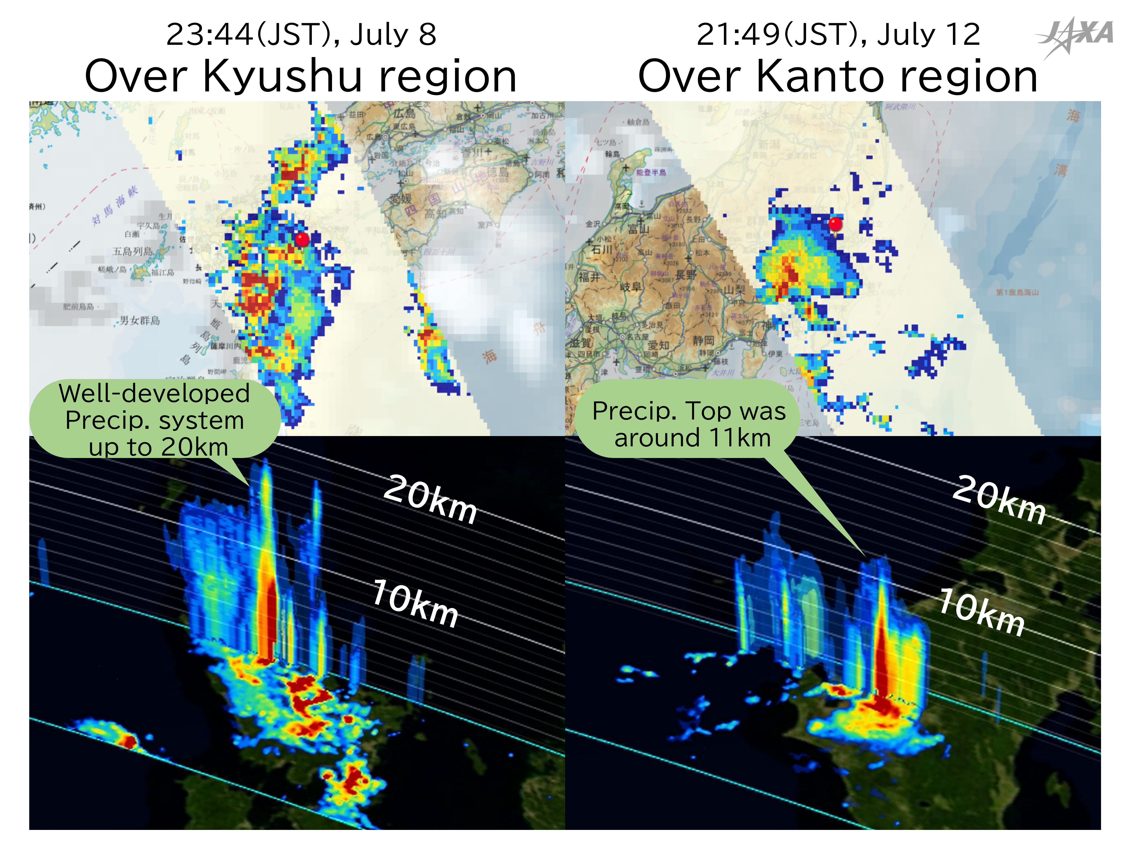
GPM/DPR also observed the record-breaking heavy rainfall that occurred around Kumamoto from late evening on July 8 to early morning on July 9. Figure 4 shows a comparison with the heavy rainfall around Saitama in Figures 1 and 3. While both cases brought heavy rainfall to the ground, the three-dimensional structure observed by the satellite shows that the precipitation system in the Kyushu region developed to an altitude of 15 km or higher, whereas that in the Kanto region did not develop so high, as shown in Figure 3.
These various characteristics, such as differences in the three-dimensional structure of precipitation, including the vertical direction, are important to understand how rainfall occurs and to improve forecast accuracy.
In addition, GPM/DPR observation data has been regularly used for numerical weather prediction by the Japan Meteorological Agency (JMA) since March 2016, and is also used in daily weather forecasts. On June 30, 2022, the usage of GPM/DPR data in the numerical weather prediction system at JMA was improved, which leads to further accuracy improvement of precipitation forecasts.
JAXA will continue to contribute to the understanding of current conditions and the accuracy improvement of disaster prediction by utilizing earth observation data including GPM/DPR.
Related Site
JAXA 3D RAINFALL WATCH
JAXA GPM Website
JAXA Climate Rainfall Watch
Search by Year
Search by Categories


Tags
-
#Earthquake
-
#Land
-
#Satellite Data
-
#Aerosol
-
#Public Health
-
#GCOM-C
-
#Sea
-
#Atmosphere
-
#Ice
-
#Today's Earth
-
#Flood
-
#Water Cycle
-
#AW3D
-
#G-Portal
-
#EarthCARE
-
#Volcano
-
#Agriculture
-
#Himawari
-
#GHG
-
#GPM
-
#GOSAT
-
#Simulation
-
#GCOM-W
-
#Drought
-
#Fire
-
#Forest
-
#Cooperation
-
#Precipitation
-
#Typhoon
-
#DPR
-
#NEXRA
-
#ALOS
-
#GSMaP
-
#Climate Change
-
#Carbon Cycle
-
#API
-
#Humanities Sociology
-
#AMSR
-
#Land Use Land Cover
-
#Environmental issues
-
#Quick Report
-
#GOSAT-GW
Related Resources


Related Tags
Disaster Related Articles
-
 Disaster 2025.10.23 Thu ALOS-2 Observations of the Earthquakes in the Philippines
(Cebu Island and Mindanao Island) -
 Disaster 2025.04.04 Fri ALOS-2 Observation of the M7.7 Earthquake in Myanmar
 -
 Disaster 2024.09.09 Mon ALOS-2 Observation of the Oil Spill Caused by the Sinking of a Tanker in Manila Bay, Philippines
 -
 Disaster 2023.04.07 Fri ALOS-2 observation: Oil spill from sunken oil tanker off Mindoro Island, Philippines (follow-up report)
Stay Connected
