


Disaster
2022.01.20 Thu
Satellite observations of the Tonga volcanic eruption
●Introduction
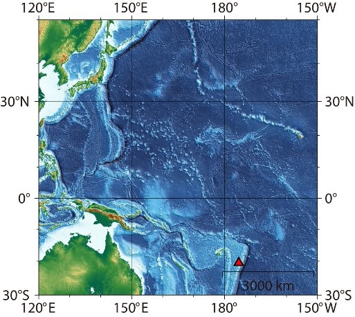
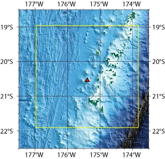
On January 15, 2022, a massive eruption occurred at Hunga-Tonga-Hunga-Ha’apai volcano (map) in the South Pacific island nation of Tonga. Tonga and neighboring countries have suffered from the damages, and the eruption also caused tumami damage in Japan. We wish to extend our deepest sympathy to all those who have suffered hardship from the disasters.
JAXA conducts the analysis by using observation information from the Advanced Land Observing Satellite-2 “DAICHI-2” (ALOS-2), the Global Change Observation Mission – Climate “SHIKISAI” (GCOM-C) etc. and provides the data to relevant organizations.
●Observation by ALOS-2
Since the volcanic eruption occurred outside Japan, JAXA has been conducting emergency observation by ALOS-2 and providing observation information in cooperation with a local organization of the Pacific Community, a member of Sentinel Asia. Sentinel Asia is an international collaboration framework for disaster prevention using space technology and JAXA takes a role of its secretariat.
Sentinel Asia: Volcano eruption in Tonga on 15 January, 2022
https://sentinel-asia.org/EO/2022/article20220115TO.html
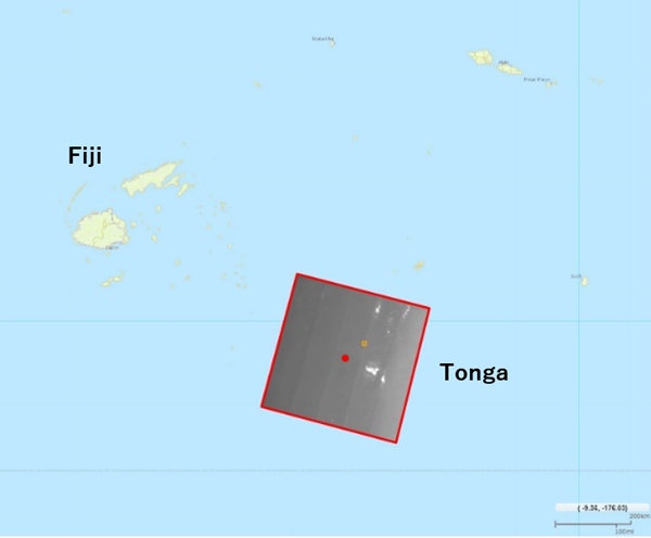
JAXA also conducted emergency observation by the Synthetic Aperture Radar, “PALSAR-2” onboard ALOS-2, which can obtain images even under clouds and plumes. Figure 1-1 shows the observation image overlaid on map when ALOS-2 performed emergency observation with wide-area mode around 23:00 on January 17, 2022 (UTC, around 8:00 on January 18, 2022 (JST))
(January 17, 2022 (UTC))
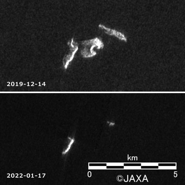
Figure 1-2 is ALOS-2 images around the Hunga-Tonga-Hunga-Ha’apai volcano on December 14, 2019 (pre-eruption) and January 17, 2022 (post-eruption). Most of the land, especially a volcanic vent existed nearly in the center of the image has disappeared by the eruption.
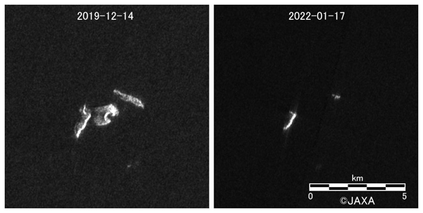
(Left) December 14, 2019, (Right) January 17, 2022
Figure 1-3 includes optical satellite imagery distributed from Europe and France on the website of the International Disasters Charter, in which JAXA also participates (original image is here). The figure compares pre-eruption image on December 8, 2021 with post-eruption image on January 16, 2022 and it also tells us the disappearance of the most parts of the Hunga-Tonga-Hunga-Ha’apai volcano island. Optical satellites have the advantage of high visibility, but as for the image of January 16, in the island area shown by the dotted line (as of December 8, 2021), the land under the clouds on the left side is not clearly visible.
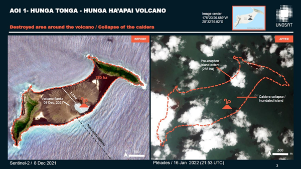
(Left) December 8, 2021 Sentinel-2 (resolution 10 m)
(Right) January 16, 2022 Pléiades (resolution 50 cm)
Copyright: Contains modified Copernicus Sentinel data (2021)
Includes Pleiades material © CNES (2022), Distribution Airbus DS.
Map produced by UNITAR / UNOSAT
The International Charter Space and Major Disasters – Volcanic eruption in Tonga and the Pacific
https://disasterscharter.org/web/guest/activations/-/article/ocean-wave-in-tonga-activation-744-
When a disaster happens, it is required to obtain information quickly and reliably, and ALOS-2 can stably check on the disaster free of the influence by plumes or clouds. Using both radar and optical satellite images can help us understand the local situation. JAXA will continue to conduct emergency observations by ALOS-2 and provide satellite images to local disaster management agencies.
●Discolored seawater observed by GCOM-C
To know the activity of volcanoes in the oceans including submarine volcanoes (underwater volcanoes) and volcanic islands (volcanoes emerged above the water), the distribution (scale) of discolored seawater and the color variation in the surrounding area are effective. Discolored seawater is originated by the reaction of hot water caused by volcanic activity with seawater.
Supplementary note: When volcanic activity is enhanced, the acidity in hot water is high and the hot water contains abundant melting iron. Depending on its density, green to reddish-brown discolored seawater is generated. As the amount of hot water increases, the amount of discolored seawater (area as seen from satellites) also increases.
As for the Hunga-Tonga-Hunga-Ha’apai volcano island, large-scale discolored seawater has been generated since December last year, and GCOM-C has captured the enhancement of the volcanic activity. Before the eruption, the distribution of discolored seawater was limited to the area around the volcanic island as seen in the Figure 2-2 (1). However, discolored seawaters were observed at the areas shown by yellow arrows on December 23 and 27 as seen in the Figures 2-2 (2) and (3). The volcanic island also erupted from December 20 to 28, therefore discolored seawater is interpreted as relevant phenomenon to the eruption.
In addition, as seen in the Figures 2-2 (4) and (5), the range of discolored seawater reached about 100 km on January 14, the day before the huge eruption and the range spread especially in large scale to 300 km on January 18, three days after the huge eruption. Since we can confirm large scale discolored seawater even after the eruption, it is possible that the volcanic activity will be ongoingly enhanced. JAXA will continue to monitor discolored seawater there.
Note that streaked light blue area seen on the right side in each figure indicates shallow water such as atolls. We will mention this point later (Figure 2-3).
(The yellow frame shows the area of satellite images in Figures 2-2 and 2-3.)

Streaked light blue area on the right side is not discolored seawater but shallow water such as atolls.
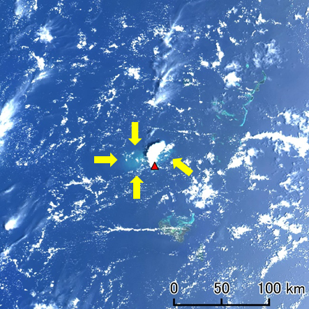
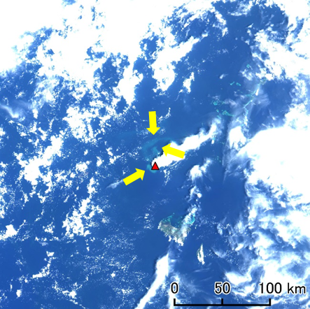
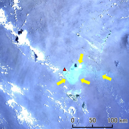
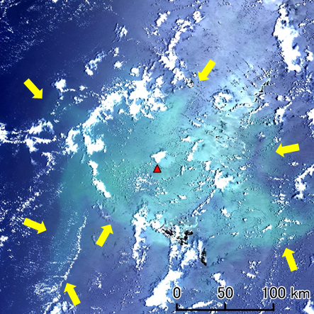
Figure 2-2 Observation image by GCOM-C around the volcanic island
Light blue areas (shown by yellow arrows) around the volcanic island (▲) indicate discolored seawater.
In each image of Figure 2-2, there are light blue parts without arrows from center right to upper right. These are considered to be shallow water such as atolls. Figure 2-3 (1) is an image observed by GCOM-C around the volcanic island before the eruption (November 19, 2021). In this image, discolored seawater cannot be seen but we can find slight light blue parts. In Figure 2-3 (2), shallow water such as atolls is shown in yellow: both images are highly consistent, so light blue parts seen before the eruption are not determined to be discolored seawater.
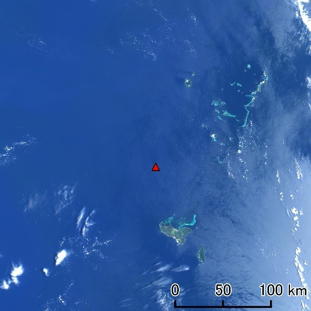
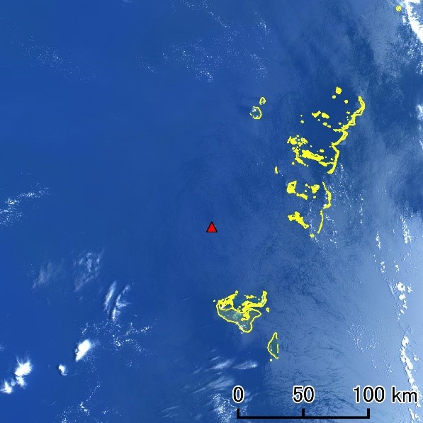
Figure 2-3 Visible image by GCOM-C around the volcanic island before the eruption and the range of shallow water. The data of shallow water is referred by “Millennium Coral Reef Mapping Project”
●Observation of pumice stones by GCOM-C
In the image observed by GCOM-C on January 18, three days after the huge eruption, something like pumice stones can be seen. We can find that they are dotted around Hunga-Tonga-Hunga-Ha’apai volcano island. Comparing to Figure 2-2, which we focused on discolored seawater, the color tone has been corrected in Figure 2-4 to recognize pumice stones. So discolored seawater looks green instead of light blue here.
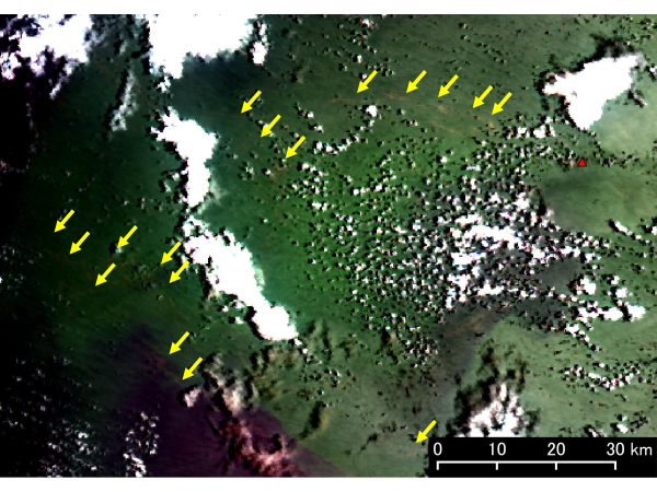
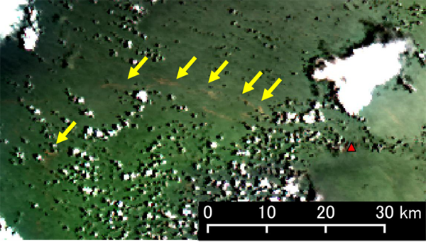
Figure 2-4 Something like pumice stones by deciphering from GCOM-C observation image around the volcanic island
Brown areas (shown by yellow arrows) around the volcanic island (▲) indicate pumice stones.
GCOM-C has a wide swath width of 1,150 km, which cross-tracks to the satellite’s path. In addition, it is capable of observing the sea surface with high precision, which makes it possible to observe ocean conditions over a wide area. JAXA has been conducting activities for monitoring discolored seawater from domestic volcanoes in the oceans (Nishinoshima Island, Fukutoku-Okanoba, etc.) using GCOM-C, together with the Japan Coast Guard and a domestic researcher (Prof. Nogami, School of Science at Tokyo Institute of Technology).
●Observations of the eruption by “Himawari” geostationary meteorological satellite
The moving images related with the eruption have already released by the Japan Meteorological Agency (JMA) and news media. Based on the Himawari data provided by JMA, JAXA processed (converted) the data to equal latitude-longitude grids and visualized, then created the moving image as below. Since the image was projected and transformed to a view seen from above, we can see the plumes and the shock waves are spreading out in a circle around the volcanic island (Figure 3-1).
(from 13:00 to 19:00 on January 15, 2022 (JST))
●Lastly
JAXA will continue the observation by ALOS-2, GCOM-C etc. and provide the information to relevant organizations. We will release additional observation results as soon as they are available.
Search by Year
Search by Categories


Tags
-
#Earthquake
-
#Land
-
#Satellite Data
-
#Aerosol
-
#Public Health
-
#GCOM-C
-
#Sea
-
#Atmosphere
-
#Ice
-
#Today's Earth
-
#Flood
-
#Water Cycle
-
#AW3D
-
#G-Portal
-
#EarthCARE
-
#Volcano
-
#Agriculture
-
#Himawari
-
#GHG
-
#GPM
-
#GOSAT
-
#Simulation
-
#GCOM-W
-
#Drought
-
#Fire
-
#Forest
-
#Cooperation
-
#Precipitation
-
#Typhoon
-
#DPR
-
#NEXRA
-
#ALOS
-
#GSMaP
-
#Climate Change
-
#Carbon Cycle
-
#API
-
#Humanities Sociology
-
#AMSR
-
#Land Use Land Cover
-
#Environmental issues
-
#Quick Report
-
#GOSAT-GW
Related Resources


Disaster Related Articles
-
 Disaster 2025.10.23 Thu ALOS-2 Observations of the Earthquakes in the Philippines
(Cebu Island and Mindanao Island) -
 Disaster 2025.04.04 Fri ALOS-2 Observation of the M7.7 Earthquake in Myanmar
 -
 Disaster 2024.09.09 Mon ALOS-2 Observation of the Oil Spill Caused by the Sinking of a Tanker in Manila Bay, Philippines
 -
 Disaster 2023.04.07 Fri ALOS-2 observation: Oil spill from sunken oil tanker off Mindoro Island, Philippines (follow-up report)
Stay Connected
