


Disaster
2021.12.27 Mon
Satellite precipitation observations of Typhoon Rai which caused damage in the Philippines
As of December 23, 2021, Typhoon Rai crossed the Philippines and caused heavy rainfall and it is reported that about 400 people were killed and the damage was very serious (reference: The Mainichi Newspaper).
Under the Global Precipitation Measurement (GPM) project, JAXA has been observing global precipitation from space using the Global Satellite Mapping of Precipitation (GSMaP), which was created by combining the Dual-frequency Precipitation Radar (DPR) onboard GPM core observatory and multiple satellites. From the perspective of providing information on precipitation condition, this article reports on satellite observations of rainfall for Typhoon Rai which caused damage in the Philippines.
The precipitation information observed by JAXA satellites introduced in this report was also used as one of the information sources in the report on Typhoon Rai by the Manila Observatory in the Philippines (Figure 1). The report shows the 24-hour accumulated precipitation by GSMaP obtained in real time. In regular post on SNS, the Manila Observatory utilized GSMaP data to indicate which area had heavy rainfall at the time of posting.

【Temporal precipitation variability associated with Typhoon Rai observed by GSMaP】
As shown in the path in Figure 2, Typhoon Rai formed in Caroline Islands located east of the Philippines on December 13, 2021 UTC (hereafter all times are UTC), then moved westwards and made landfall on the Philippines on December 16. It caused enormous damage to the Philippines. Even after passing through the Philippines, Typhoon Rai increased in power again in the South China Sea and gradually changed its path to northward then finally became tropical depression on December 20. From Figure 2, we can see that the typhoon has maintained its strong power for several days before and after its passage over the Philippines.
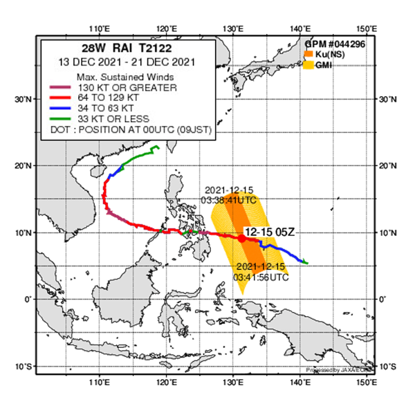
Figure 3 shows temporal precipitation variability from December 13 to 20, 2021 created by using GSMaP and it captures the typhoon passage from the east of the Philippine Sea to westward. By utilizing satellite observation data from space, we can obtain global rainfall distribution including over the oceans far from land. Therefore, GSMaP is utilized in the field of disaster prevention not limited to meteorology.
【Three-dimensional observation of precipitation from Typhoon Rai observed by the GPM core observatory】
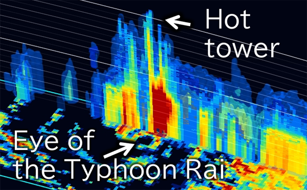
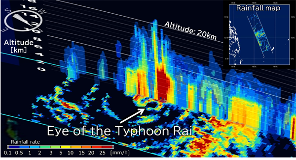
The GPM core observatory captured precipitation along with Typhoon Rai on December 15, before landing on the Philippines (Figure 4). The GPM core observatory is equipped with the Dual-frequency Precipitation Radar (DPR) developed by Japan. Since DPR is capable of observing precipitation three dimensionally, it can capture not only precipitation around land surface but also three-dimensional structure of precipitation. As shown in Fig. 4, a tower of tall, developed rain clouds is captured inside typhoon. This phenomenon is called “hot tower” as the heat is carried to the sky in the form of latent heat* when rain is generated. The rain clouds which reached an altitude of 20 km were observed and it is considered that convection has developed to very high altitudes. Please have a look at Figure 5 for the moving image of three-dimensional structure of precipitation.
*latent heat:
The process of water vapor (gases) turning into raindrops (liquids) is called condensation. “Latent heat” means the heat generated during condensation. It is an energy source of Typhoon.
(around 03:40 on December 15, 2021 (UTC))
(around 03:40 on December 15, 2021 (UTC))
These observation data of GPM/DPR also plays a useful role in our daily life through utilization for numerical weather prediction of the Japan Meteorological Agency. In order to reduce the damage like the recent disaster in the Philippines, JAXA is trying to improve the accuracy of satellite observation data and will contribute the improvement of prediction accuracy in coordination with numerical model.
Related Sites
Search by Year
Search by Categories


Tags
-
#Earthquake
-
#Land
-
#Satellite Data
-
#Aerosol
-
#Public Health
-
#GCOM-C
-
#Sea
-
#Atmosphere
-
#Ice
-
#Today's Earth
-
#Flood
-
#Water Cycle
-
#AW3D
-
#G-Portal
-
#EarthCARE
-
#Volcano
-
#Agriculture
-
#Himawari
-
#GHG
-
#GPM
-
#GOSAT
-
#Simulation
-
#GCOM-W
-
#Drought
-
#Fire
-
#Forest
-
#Cooperation
-
#Precipitation
-
#Typhoon
-
#DPR
-
#NEXRA
-
#ALOS
-
#GSMaP
-
#Climate Change
-
#Carbon Cycle
-
#API
-
#Humanities Sociology
-
#AMSR
-
#Land Use Land Cover
-
#Environmental issues
-
#Quick Report
-
#GOSAT-GW
Related Resources


Related Tags
Disaster Related Articles
-
 Disaster 2025.10.23 Thu ALOS-2 Observations of the Earthquakes in the Philippines
(Cebu Island and Mindanao Island) -
 Disaster 2025.04.04 Fri ALOS-2 Observation of the M7.7 Earthquake in Myanmar
 -
 Disaster 2024.09.09 Mon ALOS-2 Observation of the Oil Spill Caused by the Sinking of a Tanker in Manila Bay, Philippines
 -
 Disaster 2023.04.07 Fri ALOS-2 observation: Oil spill from sunken oil tanker off Mindoro Island, Philippines (follow-up report)
Stay Connected
