


Disaster
2021.10.29 Fri
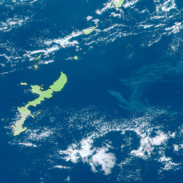
Satellite observation information on pumice stones approaching and drifting to the main island of Okinawa
Overview:
From around October 23 to the present, a massive amount of pumice stones has drifted ashore on Okinawa prefecture, causing damage on ship navigation, fishing and tourism. The stones were produced by the August 13 eruption of Fukutoku-Okanoba, a submarine volcano south of the Ogasawara Islands. They have drifted on the ocean for two months and reached to the main island of Okinawa, located more than 1,400 km away from the volcano. JAXA captures the distribution of pumice stones on the surface of the sea by satellite observation images and provides information to relevant organizations. We will introduce the main optical (visible, infrared) satellite images and Synthetic Aperture Radar (SAR) image which are used for the analysis of pumice distribution.
If you have any inquiries, please contact at: earth*ml.jaxa.jp (please replace * with @)
Reference: The article about the eruption of Fukutoku-Okanoba (creation of new islands, pumice stones, etc.) was released on Earth-graphy on October 7.
Also, the latest GCOM-C images related to the pumice stones are posted on the special website.
1. Pumice observation by optical (visible) satellite image
The Second-Generation Global Imager (SGLI) onboard the Global Change Observation Mission – Climate “SHIKISAI” (GCOM-C) has a wide swath width of 1,150 km and is capable of observing the sea surface over a wide area. Figures 1.1-1.4 show the distribution of the pumice stones captured by “SHIKISAI”.
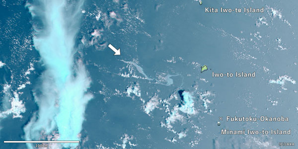
The pumice stones were produced by the eruption of submarine volcano and mainly stayed at one place together soon after the eruption. They were concentrated in an area of several tens of kilometers (Fig. 1.1). This scene was captured by aircraft observation of the Japan Coast Guard (JCG) (reference: the released document from JCG (Fig. 3. Condition of floating matter (taken at 15:08 on August 16, 2021))). However, after passing more than one month, it can be found that the distribution of pumice was separated into different parts (Figs. 1.2-1.4) (reference: the released document from the JCG (overall)).
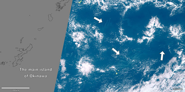
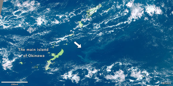
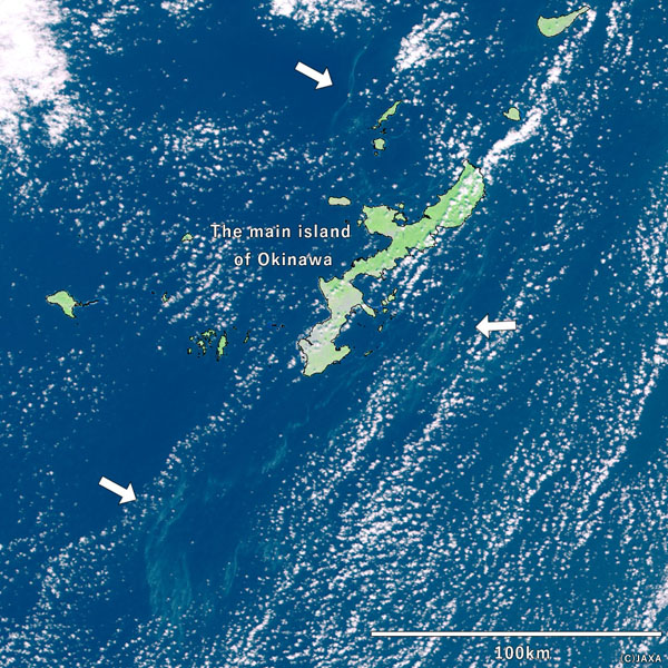
The white parts in Figures 1.1-1.4 are clouds and the light blue streaks under the clouds are likely to be pumice distribution (indicated by arrows in Figs.). In these images, the distribution of gray pumice is colored light blue because it is visualized using a combination of red, near infrared and short-wave infrared wavelength bands. While it is easy to determine pumice on the surface of the sea from visible images, the satellite is unable to observe under clouds, and pumice cannot be observed on bad weather days. We are trying to provide the information to relevant organizations.
2. Pumice observation by Synthetic Aperture Radar (SAR) image
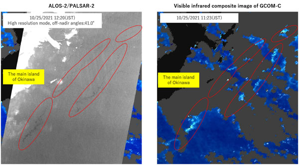
The Advanced Land Observing Satellite-2 “DAICHI-2” (ALOS-2) is equipped with a Synthetic Aperture Radar (SAR). By emitting microwave and observing the reflection from the ground, it is capable of observing in all weather conditions. Figure 2.1 shows an observation image around Okinawa captured by ALOS-2 (left, taken on October 25) and a visible infrared composite image of GCOM-C on the same day (right). We are trying to recognize the pumice by the difference in radar reflection between the normal sea surface and the sea surface with floating pumice, including the comparison with visible infrared image. It shows that the bright zone in the visible infrared image appears dark in the radar image. In case the radar observes sea surface, when ocean waves are calm, it looks darker than when there are waves because the reflection from the sea surface is smaller. In the area where pumice stones are floating on the sea surface, waves are smaller than the normal sea surface, so it is considered that the area looks darker than its surroundings.
Search by Year
Search by Categories


Tags
-
#Earthquake
-
#Land
-
#Satellite Data
-
#Aerosol
-
#Public Health
-
#GCOM-C
-
#Sea
-
#Atmosphere
-
#Ice
-
#Today's Earth
-
#Flood
-
#Water Cycle
-
#AW3D
-
#G-Portal
-
#EarthCARE
-
#Volcano
-
#Agriculture
-
#Himawari
-
#GHG
-
#GPM
-
#GOSAT
-
#Simulation
-
#GCOM-W
-
#Drought
-
#Fire
-
#Forest
-
#Cooperation
-
#Precipitation
-
#Typhoon
-
#DPR
-
#NEXRA
-
#ALOS
-
#GSMaP
-
#Climate Change
-
#Carbon Cycle
-
#API
-
#Humanities Sociology
-
#AMSR
-
#Land Use Land Cover
-
#Environmental issues
-
#Quick Report
-
#GOSAT-GW
Related Resources


Disaster Related Articles
-
 Disaster 2025.10.23 Thu ALOS-2 Observations of the Earthquakes in the Philippines
(Cebu Island and Mindanao Island) -
 Disaster 2025.04.04 Fri ALOS-2 Observation of the M7.7 Earthquake in Myanmar
 -
 Disaster 2024.09.09 Mon ALOS-2 Observation of the Oil Spill Caused by the Sinking of a Tanker in Manila Bay, Philippines
 -
 Disaster 2023.04.07 Fri ALOS-2 observation: Oil spill from sunken oil tanker off Mindoro Island, Philippines (follow-up report)
Stay Connected
