


Disaster
2021.07.05 Mon
Observation of heavy rainfall in the Tokai and the southern Kanto regions along with an active rainy baiu front
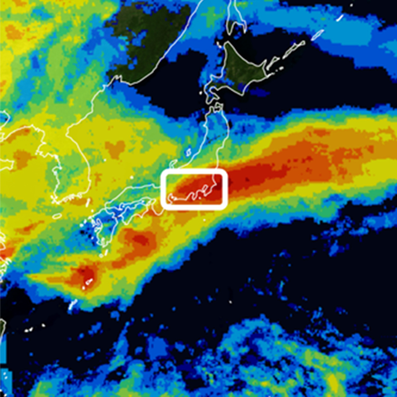
As of July 5, 2021, an active rainy baiu front is stalling near Japan and causing enormous damage particularly in the Tokai and the southern Kanto regions. We wish to extend our deepest sympathy to all those who have suffered hardship from the disasters.
From the perspective of providing information on precipitation condition, JAXA conducted the analysis using data from the Global Precipitation Measurement (GPM) core observatory, the Global Satellite Mapping of Precipitation (GSMaP), etc., which observe condition of rain from space.
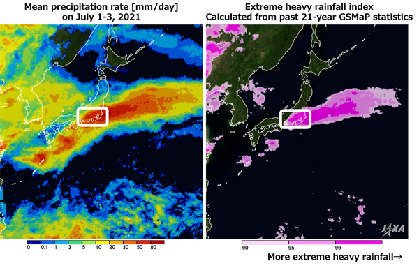
Figure 1 shows the distribution of mean precipitation (left) during the period of July 1–3, 2021 (UTC) by GSMaP and extreme heavy rainfall index (right) during the same period calculated from GSMaP statistics in the past 21 years. The rainy front over the south of Japan at the end of June moved toward north in July and brought heavy rain mainly on the Pacific side. From the precipitation information by the satellite shown in Fig. 1 (left), heavy rainfall can be seen particularly in the Tokai and the southern Kanto regions where landslides and other damage have been reported. It shows that the area had continuous heavy rainfall exceeding 50 mm/day on average for three days.
Fig. 1 (right) shows extreme heavy rainfall index during the period of July 1–3, 2021 (UTC) calculated from GSMaP statistics in the past 21 years. Dark pink area indicates how extreme the rainfall was during the period of July 1–3, 2021 (UTC) comparing with the mean precipitation of the same period in the past 21 years. We can find the tendency that the Tokai and the Kanto regions had heavy rainfall.
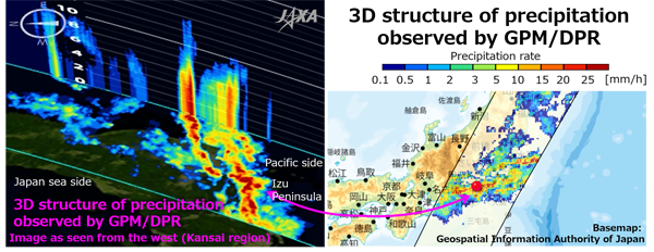
In addition, JAXA conducts accurate three-dimensional observations of rain in the world by using Dual-frequency Precipitation Radar (DPR) onboard GPM core observatory. Figure 2 shows three-dimensional conformation of precipitation when DPR observed the part of the Tokai and the Kanto regions. Development of rain clouds up to more than 10 km height was observed around Atami (3D moving image is here).
(3D moving image is here)
DPR is the only instrument which can measure rain in three dimensions with high accuracy from space. By three-dimensional observation of precipitation, we can promote better understanding of characteristics of rainfall and contribute to the improvement of weather forecasting models to estimate rainfall. The observation data of DPR has operationally utilized for numerical weather prediction of the Japan Meteorological Agency since March 2016 and the data plays a useful role in daily weather forecast.
With the need to review disaster prevention and evacuation measures in the society coexisting with COVID-19, JAXA will contribute to understanding the existing conditions and accuracy improvement of disaster prediction by using satellite observation data from DPR, GSMaP, etc.
Related Sites
JAXA Global Rainfall Watch
JAXA Climate Rainfall Watch
JAXA GPM Website
Search by Year
Search by Categories


Tags
-
#Earthquake
-
#Land
-
#Satellite Data
-
#Aerosol
-
#Public Health
-
#GCOM-C
-
#Sea
-
#Atmosphere
-
#Ice
-
#Today's Earth
-
#Flood
-
#Water Cycle
-
#AW3D
-
#G-Portal
-
#EarthCARE
-
#Volcano
-
#Agriculture
-
#Himawari
-
#GHG
-
#GPM
-
#GOSAT
-
#Simulation
-
#GCOM-W
-
#Drought
-
#Fire
-
#Forest
-
#Cooperation
-
#Precipitation
-
#Typhoon
-
#DPR
-
#NEXRA
-
#ALOS
-
#GSMaP
-
#Climate Change
-
#Carbon Cycle
-
#API
-
#Humanities Sociology
-
#AMSR
-
#Land Use Land Cover
-
#Environmental issues
-
#Quick Report
-
#GOSAT-GW
Related Resources


Related Tags
Disaster Related Articles
-
 Disaster 2025.10.23 Thu ALOS-2 Observations of the Earthquakes in the Philippines
(Cebu Island and Mindanao Island) -
 Disaster 2025.04.04 Fri ALOS-2 Observation of the M7.7 Earthquake in Myanmar
 -
 Disaster 2024.09.09 Mon ALOS-2 Observation of the Oil Spill Caused by the Sinking of a Tanker in Manila Bay, Philippines
 -
 Disaster 2023.04.07 Fri ALOS-2 observation: Oil spill from sunken oil tanker off Mindoro Island, Philippines (follow-up report)
Stay Connected
