


Disaster
2021.03.08 Mon
The Great East Japan Earthquake – JAXA Earth Observation Record
March 11, 2021 marks 10 years since the Great East Japan Earthquake. We extend our deepest sympathies to all those in the affected areas. We would like to have a look back at the earth observation sites and disaster observation sites at the time of the earthquake for record keeping. In this series of articles, we will introduce the record of that time, the 10 years of reconstruction as seen from space, and JAXA’s disaster prevention efforts over the past 10 years.
A huge earthquake occurred! How did JAXA’s Earth observation site operate?
At around 14:46 JST on March 11, 2011, a 9.0 magnitude earthquake, the largest earthquake ever recorded in Japan, occurred off the Pacific coast of the Tohoku region.
The JAXA Tsukuba Space Center was hit by a quake with an intensity of just under 6 on the Japanese seismic scale. Although the buildings and equipment were damaged in the Center, fortunately, there was no direct damage to personnel or satellite flight products. After the earthquake, JAXA immediately began preparations for emergency observations using the Advanced Land Observing Satellite “DAICHI” (ALOS), while we were engaged in internal damage assessment.
10 years after the Great East Japan Earthquake – Leveraging knowledge and connecting to the future (JAXA Ground Facilities Department)
The timing of communication with satellites in space is limited. The timing of their passage over the affected area is also limited. Although the Tsukuba Space Center was also damaged, we made a plan to control the satellite and prepared the timing for ALOS to pass over the affected area the next morning.
Emergency observations require quick decisions to make the most of limited observation opportunities. The observation plan was determined based on various factors, such as the satellite’s observable area, imaging capabilities, and areas where damage has not yet been cleared by ground searches and aircraft observations.
Then, on the morning of the day after the earthquake, we were able to make an emergency observation across the Tohoku region, 70 km wide and 350 km long. Further observations were made over several days, and by March 14, the entire Tohoku coastline was clear and the full extent of the tsunami damage was captured for the first time (Figure 1).
Following the earthquake, numerous aircraft and helicopters were deployed to the areas affected by the tsunami. However, flights within a 30 km radius of the Fukushima Daiichi Nuclear Power Plant were prohibited, making it impossible to obtain a complete picture even with aircraft observation. Under these circumstances, observing a wide area at once from space could reveal the full picture of a large-scale disaster for the first time.
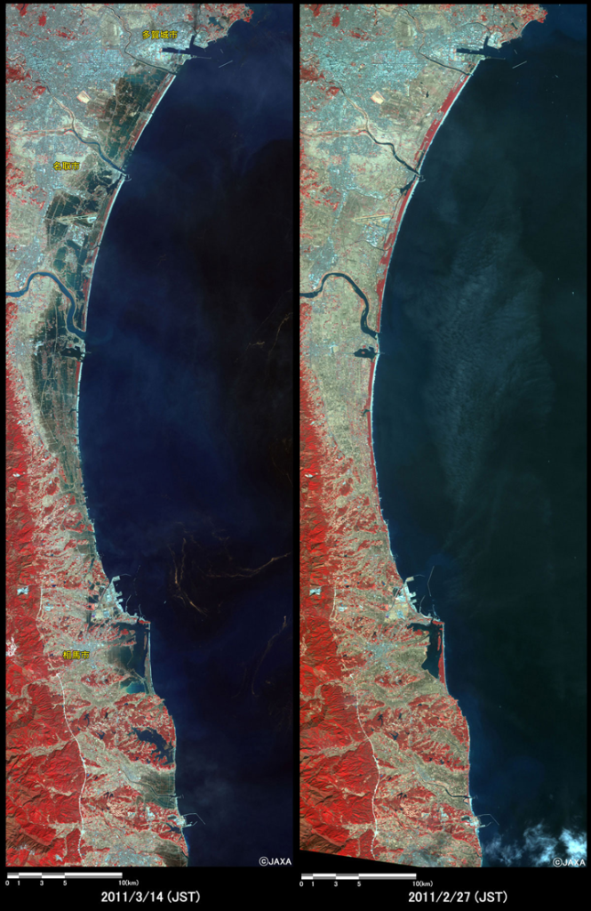
(Areas inundated by the tsunami are highlighted in dark blue. Areas with vegetation are shown in red. Floating debris that may have been washed out to sea by the tsunami can also be seen.)
Detail of Figure 1: Advanced Land Observing Satellite “DAICHI” (ALOS) emergency observation results of the Great East Japan Earthquake
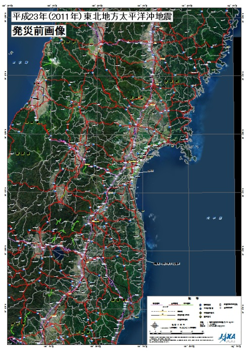
Although obtaining satellite data takes time, government agencies were provided with previously observed pre-disaster data on the same day of the earthquake. Especially during times of disaster, information can be confusing. Since the analysis of satellite data requires specialized knowledge, JAXA has prepared maps that provide a variety of information in an easy-to-understand format, such as the “Daichi satellite image maps”, and is working to make this information available to related organizations (Figure 2).
The JAXA Disaster Management Support Systems Office in Otemachi, Tokyo, was responsible for providing information to government agencies in Kasumigaseki. Some staff members stayed at work overnight while transportation and communications were disrupted in the immediate aftermath of the earthquake, carrying large-print satellite images on their backs and cycling them to Kasumigaseki in the middle of the night.
Monitoring the affected area through international cooperation
JAXA’s satellites alone are limited in their observation capabilities, so the Great East Japan Earthquake also benefited from the international cooperation framework of the International Charter ‘Space and Major Disasters’ and Sentinel Asia. Within an hour of the earthquake, a request for assistance was made and emergency observations were initiated through international cooperation. In the end, with the cooperation of 27 overseas satellites from 14 countries and regions, we were able to acquire a huge amount of satellite data, amounting to more than 5,700 scenes. These satellite data have been analyzed by research institutes around the world.
There was also the discovery by the United States Geological Survey (USGS) of an SOS message written in a park in Miyagi Prefecture. It is important to note that the analysis was conducted with the cooperation of many individuals to extract valuable information from a large amount of data.
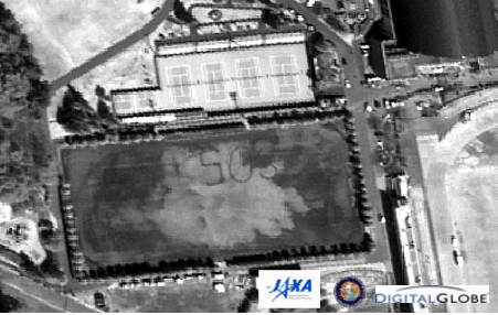
(March 19, 2011, Onagawa Sports Park, Miyagi Prefecture. JAXA contacted Miyagi Prefecture promptly and verified the safety of the evacuation site.)
JAXA has concluded agreements with overseas space agencies and international organizations to promote cooperation in emergency observation support and research & development. We have implemented a system of mutual cooperation, such as utilizing JAXA’s satellites to conduct emergency observations during overseas disasters. Further details will be presented in upcoming articles.
International Charter ‘Space and Major Disasters’
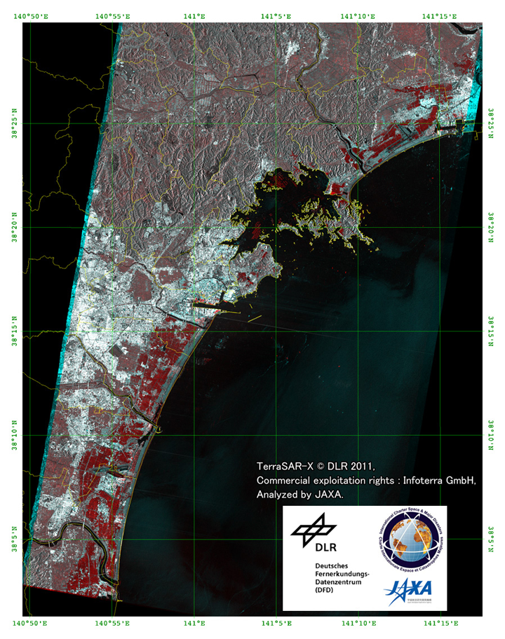
Detail of Figure 4: Observation results of the Great East Japan Earthquake by TerraSAR-X

Cooperation with government agencies and disaster management organizations
We spent many days analyzing the vast amount of satellite data coming in from overseas partner organizations and providing the results of our analysis to the relevant organizations.
For several days after the disaster, the water supply was cut off and the cafeteria was closed at the Tsukuba Space Center, but some staff members managed to procure food at a supermarket where supplies were limited and continued their analysis day and night. Some staff members worked while carrying valuables so they could be evacuated at any time during the gas shortage.
Despite these difficulties, JAXA was able to obtain analysis results from a wide range of areas, including landslides, bridge and dike damage, tsunami inundation, tsunami-driven debris, crustal deformation, liquefaction, and fire conditions.
The results of more than 1,700 analyses of about 80 types of data obtained through the above disaster monitoring efforts were promptly provided to government agencies, disaster prevention agencies, and local governments, and were used for damage assessment, disaster relief, and reconstruction.

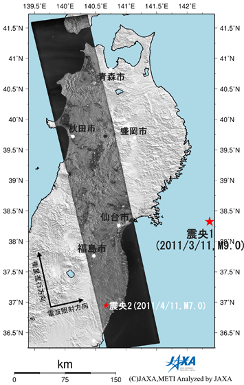
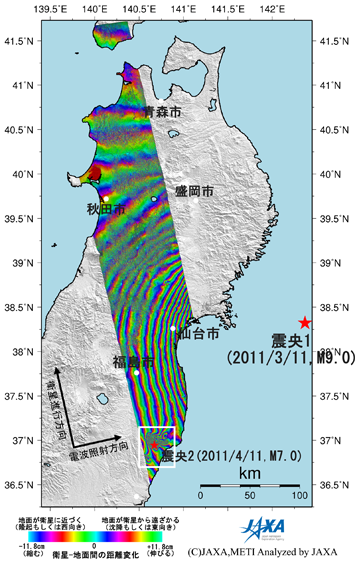
Figure 5. Crustal deformation analysis results by ALOS (Japanese only)
Detail of Figure 5: ALOS emergency observation results of the Great East Japan Earthquake

Through the Group on Earth Observations (GEO), an intergovernmental organization, data were also made available to earthquake researchers around the world for scientific use, including research into the mechanism of the Great East Japan Earthquake and Tsunami.
Satellites to succeed the mission of “DAICHI”(ALOS)
Since its launch in January 2006, ALOS has continued to observe worldwide, including Japan. Due to the availability of ALOS long term data prior to the earthquake, we were able to promptly extract changes from the results of emergency observations. This allowed us to contribute to the identification of widespread damage and clarification of crustal deformation. However, on April 22, 2011, six weeks after the earthquake, the observation was interrupted due to an electrical power system fault, and on May 12, 2011, the operation was terminated without recovery.
At the time of the Great East Japan Earthquake, ALOS had already exceeded its design life (target) of five years, and emergency observations and power system disturbances are considered technically unrelated events. However, ALOS’s sense of mission may have enabled it to complete 643 observations between the earthquake occurrence and the stop of observations, even after exceeding its design life.
Currently, the Advanced Land Observing Satellite-2 “DAICHI-2” (ALOS-2) (launched in May 2014), the successor to ALOS, is conducting observations related to disaster prevention. Then, ALOS-3 and ALOS-4 are scheduled for launch in FY2021 and FY2022, respectively. Continuing the mission of ALOS, which observed the Great East Japan Earthquake, we will continue to monitor the safety and security of society from space by installing more advanced sensors.
Advanced Land Observing Satellite “DAICHI” (ALOS)
Advanced Land Observing Satellite-2 “DAICHI-2” (ALOS-2)
Advanced Optical Satellite “DAICHI-3” (ALOS-3)
Advanced Land Observing Satellite-4 “DAICHI-4” (ALOS-4)
The efforts of JAXA other than Earth observation
Space technology, which includes satellite communications, space science, and human space exploration, can be a valuable asset in the unique circumstances of a disaster. Following the Great East Japan Earthquake, JAXA has undertaken various activities in addition to Earth observation. Additional information can be found here.
- Provision of satellite communication lines via satellite
- Polarimetric and Interferometric Airborne Synthetic Aperture Rad (Pi-SAR-L2) to search for remains
- Cooperation in measuring radiation levels around Fukushima Daiichi nuclear power plant using experimental aircraft
- Visualization of radioactive materials with “Ultra-Wide-Angle Compton Camera”
- Support from companies through JAXA COSMODE PROJECT products
- Rental of staff accommodations
Disaster prevention efforts after the earthquake
Over the past decade, Earth observation field in JAXA has responded to emergency observations of many overseas disasters, developed technologies such as disaster simulation, and strengthened cooperation with related organizations. At the time of the earthquake, the Global Change Observation Mission – Water “SHIZUKU” (GCOM-W) and Global Precipitation Measurement (GPM) were in the pre-launch development phase, but fortunately, they were not directly damaged by the disaster. GCOM-W and GPM now play an important role in monitoring the global environment and heavy rainfall disasters from space.
Satellite data is now available to provide insight into the state of reconstruction over the past decade. Our next article will provide additional information about JAXA’s disaster prevention efforts over the past decade and the 10-year recovery.
Reference
JAXA’s Disaster Response Support Activities for the Great East Japan Earthquake
“Report on JAXA’s Response to the Great East Japan Earthquake” – Assistance using earth observation satellites and communication satellites –
(A detailed disaster response report is available.)
Advanced Land Observing Satellite Disaster Prevention/Disaster 2011
(Satellite images of various areas taken at the time of the earthquake are available to the public in their original form)
* Satellite data is used by government agencies and disaster management organizations for damage estimation and damage monitoring, but requires a high level of expertise for analysis and interpretation. In case of disaster, please refer to the information from Government agencies and your municipality.
Explanation of the Images
Figure 1
| Satellite | Advanced Land Observing Satellite “DAICHI” (ALOS) |
|---|---|
| Sensor | Advanced Visible and Near Infrared Radiometer type 2 (AVNIR-2) |
| Date | Left: March 14, 2011 (JST)
Right: February 27, 2011 (JST) |
Figure 4
| Satellite | TerraSAR-X |
|---|---|
| Date | Red: October 21, 2010
Green, Blue: March 13, 2011 |
Figure 5
| Satellite | Advanced Land Observing Satellite “DAICHI” (ALOS) |
|---|---|
| Sensor | Phased array type L-band synthetic aperture radar (PALSAR) |
Related Sites
- 10 years after the Great East Japan Earthquake – Leveraging knowledge and connecting to the future (JAXA Ground Facilities Department)
- Detail of Figure 1: Advanced Land Observing Satellite “DAICHI” (ALOS) emergency observation results of the Great East Japan Earthquake
- Detail of Figure 4: Observation results of the Great East Japan Earthquake by TerraSAR-X
- Detail of Figure 5: ALOS emergency observation results of the Great East Japan Earthquake
- International Charter ‘Space and Major Disasters’
- Sentinel Asia
- Advanced Land Observing Satellite “DAICHI” (ALOS)
- Advanced Land Observing Satellite-2 “DAICHI-2” (ALOS-2)
- Advanced Optical Satellite “DAICHI-3” (ALOS-3)
- Advanced Land Observing Satellite-4 “DAICHI-4” (ALOS-4)
- JAXA’s Disaster Response Support Activities for the Great East Japan Earthquake
- “Report on JAXA’s Response to the Great East Japan Earthquake” – Assistance using earth observation satellites and communication satellites –
- Advanced Land Observing Satellite Disaster Prevention/Disaster 2011
- Updates on Earth: Disaster
Search by Year
Search by Categories


Tags
-
#Earthquake
-
#Land
-
#Satellite Data
-
#Aerosol
-
#Public Health
-
#GCOM-C
-
#Sea
-
#Atmosphere
-
#Ice
-
#Today's Earth
-
#Flood
-
#Water Cycle
-
#AW3D
-
#G-Portal
-
#EarthCARE
-
#Volcano
-
#Agriculture
-
#Himawari
-
#GHG
-
#GPM
-
#GOSAT
-
#Simulation
-
#GCOM-W
-
#Drought
-
#Fire
-
#Forest
-
#Cooperation
-
#Precipitation
-
#Typhoon
-
#DPR
-
#NEXRA
-
#ALOS
-
#GSMaP
-
#Climate Change
-
#Carbon Cycle
-
#API
-
#Humanities Sociology
-
#AMSR
-
#Land Use Land Cover
-
#Environmental issues
-
#Quick Report
-
#GOSAT-GW
Related Resources


Related Tags
Disaster Related Articles
-
 Disaster 2025.10.23 Thu ALOS-2 Observations of the Earthquakes in the Philippines
(Cebu Island and Mindanao Island) -
 Disaster 2025.04.04 Fri ALOS-2 Observation of the M7.7 Earthquake in Myanmar
 -
 Disaster 2024.09.09 Mon ALOS-2 Observation of the Oil Spill Caused by the Sinking of a Tanker in Manila Bay, Philippines
 -
 Disaster 2023.04.07 Fri ALOS-2 observation: Oil spill from sunken oil tanker off Mindoro Island, Philippines (follow-up report)
Stay Connected
