


Disaster
2019.07.05 Fri
Observation of record-breaking rainfall in the Kyushu region due to an active Baiu front
As of July 5, 2019, an active Baiu front has been stagnating near Honshu for an extended period of time, causing severe damage in various areas, particularly in the Kyushu region. We wish to extend our deepest sympathy to all those who have suffered hardship from the disasters.
From the perspective of providing information on precipitation condition, JAXA/EORC conducted the analysis using data from the Global Precipitation Measurement (GPM) core observatory, the Global Satellite Mapping of Precipitation (GSMaP), etc., which observe condition of rain from space.
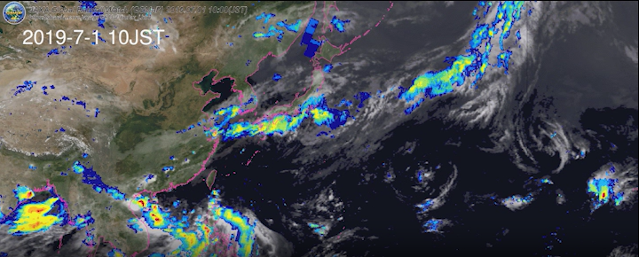
Figure 1 shows the temporal variation of rainfall by GSMaP since the end of June, when rainfall began in the Kyushu region.
*What is the Global Satellite Mapping of Precipitation (GSMaP)? … GSMaP is a global precipitation map created from satellite data for multiple precipitation observations.
Typhoon “SEPAT” was the first typhoon in Reiwa to hit Japan since the evening of June 27, 2019. When it passed over the Kanto and Tokai regions on June 28, a linear precipitation band was already visible over Kyushu. Although the rain clouds then moved eastward from the Honshu area, a broad band of rain clouds associated with the Baiu front again covered Kyushu, Kanto, and Tohoku from June 29 to 30. In July, a band of rain clouds extending east to west from the East China Sea to Kyushu and southeast of Kanto has been stagnant for a long period of time. We can see that precipitation has also increased since July 3. On July 4, the Baiu front moved southward again, but heavy precipitation continues to be observed over the southern seas of Japan, and caution continues to be urged in Okinawa and other areas.
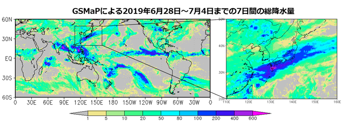
Two major advantages of GSMaP are (1) the ability to obtain rainfall distribution around the world, including over the oceans far from Japan, and (2) the ability to directly determine the amount of precipitation, rather than cloud information. Figure 2 shows the total precipitation for 7 days from June 28 to July 4, 2019. As can be seen in the figure, the area around Japan is the wettest region in the world at this time of year. In particular, if we zoom in on the area of Japan, we can see that more than 600 mm of rain was observed in southern Kyushu.
In addition, JAXA conducts accurate three-dimensional observations of rain in the world by using Dual-frequency Precipitation Radar (DPR) onboard GPM core observatory. Figure 3 shows three-dimensional conformation of precipitation when DPR observed the part of the precipitation band associated with the Baiu front. It shows the tall, strong rains observed in some places.
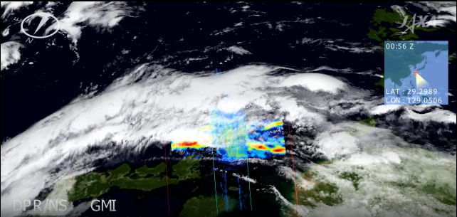
DPR is the only instrument which can measure rain in three dimensions with high accuracy from space. The observation is helpful for our daily life through utilization of weather forecast by the Japan Meteorological Agency.
Related Sites
Search by Year
Search by Categories


Tags
-
#Earthquake
-
#Land
-
#Satellite Data
-
#Aerosol
-
#Public Health
-
#GCOM-C
-
#Sea
-
#Atmosphere
-
#Ice
-
#Today's Earth
-
#Flood
-
#Water Cycle
-
#AW3D
-
#G-Portal
-
#EarthCARE
-
#Volcano
-
#Agriculture
-
#Himawari
-
#GHG
-
#GPM
-
#GOSAT
-
#Simulation
-
#GCOM-W
-
#Drought
-
#Fire
-
#Forest
-
#Cooperation
-
#Precipitation
-
#Typhoon
-
#DPR
-
#NEXRA
-
#ALOS
-
#GSMaP
-
#Climate Change
-
#Carbon Cycle
-
#API
-
#Humanities Sociology
-
#AMSR
-
#Land Use Land Cover
-
#Environmental issues
-
#Quick Report
-
#GOSAT-GW
Related Resources


Related Tags
Disaster Related Articles
-
 Disaster 2025.10.23 Thu ALOS-2 Observations of the Earthquakes in the Philippines
(Cebu Island and Mindanao Island) -
 Disaster 2025.04.04 Fri ALOS-2 Observation of the M7.7 Earthquake in Myanmar
 -
 Disaster 2024.09.09 Mon ALOS-2 Observation of the Oil Spill Caused by the Sinking of a Tanker in Manila Bay, Philippines
 -
 Disaster 2023.04.07 Fri ALOS-2 observation: Oil spill from sunken oil tanker off Mindoro Island, Philippines (follow-up report)
Stay Connected
