


Disaster
2018.07.10 Tue
Observation of the Heavy Rain Event of July 2018 in Japan by the Global Precipitation Measurement (GPM)
The Heavy Rain Event of July 2018 caused extensive damage over a wide area, including Kyushu, Chugoku, Shikoku, and Kinki regions. We wish to extend our deepest sympathy to all those who have suffered hardship from the disasters. JAXA continuously monitors precipitation conditions using the Global Precipitation Measurement (GPM) core observatory and the Global Satellite Mapping of Precipitation (GSMaP). From the perspective of providing information on precipitation conditions, JAXA/EORC analyzed GPM data.
【Overview】
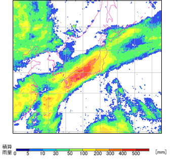
Typhoon No. 7 formed at the end of June 2018 and approached Japan from the southern coast of Japan through the Sea of Japan on July 4. In addition, the activity of the rainy baiu front, which had been stagnant in western and eastern Japan, continued to be active from July 5, bringing record heavy rainfall over a wide area, especially in western Japan (Figure 1).
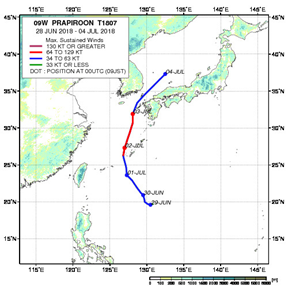
Figure 1. The path of Typhoon No. 7 (left) and the 72-hour accumulated rainfall from 10:00 on July 5 to 9:59 on July 8, based on GSMaP (right)
【Three-dimensional observation of precipitation associated with the rainy baiu front, which brought heavy rainfalls, by the GPM core observatory】
The GPM core observatory passed over the Japanese archipelago at around 19:30 on July 5 (JST) and around 9:30 on July 7 (JST) and observed precipitation associated with an active rainy baiu front (Figures 2 and 3). The GPM core observatory is equipped with the Dual-frequency Precipitation Radar (DPR) developed by Japan and the GPM Microwave Imager (GMI) developed by NASA. DPR is capable of three-dimensional precipitation observation, capturing not only near the ground surface but also the vertical structure of precipitation extending up to 10 km in height.
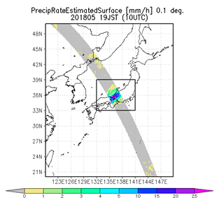
Figure 2. Precipitation distribution near the ground (top) and three-dimensional distribution of precipitation (bottom) observed by the GPM/DPR at around 19:30 on July 5 (JST)
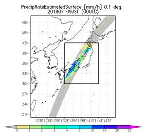
Figure 3. Precipitation distribution near the ground (top) and three-dimensional distribution of precipitation (bottom) observed by the GPM/DPR at around 9:30 on July 7 (JST).
Three-dimensional observations of precipitation by the DPR will enhance our understanding of the characteristics of rainfall in different regions and can contribute to improving weather forecast models that estimate rainfall. Observation data of GPM have been regularly used for numerical prediction by the Japan Meteorological Agency (JMA) since March 2016. The data is also useful for daily weather forecasts.
【Temporal variability of precipitation distribution by GSMaP】
The GSMaP product calculates global precipitation distribution from GPM core observatory data and data from multiple constellation satellites (satellites from countries and organizations participating in the GPM project), including AMSR2 aboard the Global Change Observation Mission – Water “SHIZUKU” (GCOM-W). Figure 4 is a moving image of the time variation of precipitation at the ground surface from July 1, 2018 at 9:00 (JST) to July 8, 2018 at 8:00 (JST). Typhoon No. 7, which formed at the end of June, was observed to approach from the southern seas of Japan, cross the Sea of Japan, and become a tropical cyclone between July 1 and 4. In addition, the rainy baiu front that had been stagnating in western and eastern Japan remained active since around July 5, and heavy rain continued for several days over a wide area, including the Kinki to Chugoku-Shikoku regions.
Figure 4. Temporal changes in precipitation from July 1, 9:00 (JST) to July 8, 8:00 (JST) by GSMaP. The top column shows the accumulated rainfall from the initial time, and the bottom column shows the hourly precipitation.
The latest GSMaP observation images are available on the JAXA Global Rainfall Watch website.
Related Sites
Search by Year
Search by Categories


Tags
-
#Earthquake
-
#Land
-
#Satellite Data
-
#Aerosol
-
#Public Health
-
#GCOM-C
-
#Sea
-
#Atmosphere
-
#Ice
-
#Today's Earth
-
#Flood
-
#Water Cycle
-
#AW3D
-
#G-Portal
-
#EarthCARE
-
#Volcano
-
#Agriculture
-
#Himawari
-
#GHG
-
#GPM
-
#GOSAT
-
#Simulation
-
#GCOM-W
-
#Drought
-
#Fire
-
#Forest
-
#Cooperation
-
#Precipitation
-
#Typhoon
-
#DPR
-
#NEXRA
-
#ALOS
-
#GSMaP
-
#Climate Change
-
#Carbon Cycle
-
#API
-
#Humanities Sociology
-
#AMSR
-
#Land Use Land Cover
-
#Environmental issues
-
#Quick Report
-
#GOSAT-GW
Related Resources


Related Tags
Disaster Related Articles
-
 Disaster 2025.10.23 Thu ALOS-2 Observations of the Earthquakes in the Philippines
(Cebu Island and Mindanao Island) -
 Disaster 2025.04.04 Fri ALOS-2 Observation of the M7.7 Earthquake in Myanmar
 -
 Disaster 2024.09.09 Mon ALOS-2 Observation of the Oil Spill Caused by the Sinking of a Tanker in Manila Bay, Philippines
 -
 Disaster 2023.04.07 Fri ALOS-2 observation: Oil spill from sunken oil tanker off Mindoro Island, Philippines (follow-up report)
Stay Connected
