


Disaster
2018.06.15 Fri
Activities of Kilauea volcano in May 2018, observed by “Shikisai”
In Kilauea volcano in Hawaii Island (Fig. 1), a fissure eruption occurred in lower Puna district on the foot of the East Rift Zone on May 3, after a collapse occurred at Puu Oo crater on April 30, 2018 (United States Geological Survey). On 17th, an explosive eruption occurred at Halemaumau crater which lies in the caldera on the summit of Kilauea. Even after this, the fissure eruption in lower Puna district continued causing many cases of damage including burning-down of houses in the vicinity.
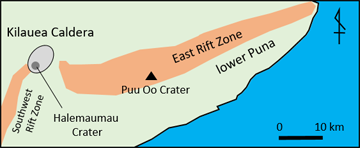
Fig. 1. Locations of Kilauea volcano and the East Rift Zone. The size and range correspond to that shown on the images of “Shikisai” in Fig. 2.
Images of “Shikisai” were able to observe those activities of Kilauea volcano. Fig. 2 shows occurrences of lava flows observed by the infrared images. In the image on May 5, thermal anomalies are noticed in the caldera on the summit of Kilauea (including Halemaumau crater) and in PuuOo crater. These seem to be due to temporary increase in thermal emission in the areas relating to the collapse or eruption events. In addition, weak thermal anomalies (arrows) lined in the east-northeast – west-south-west direction, the same direction as that of the East Rift Zone, is recognized in the lower Puna district. These are considered to be the occurrence point of the fissure eruption and its deposits in the early stage. In the image on 16th, it is observed that the thermal-anomaly areas expand and extend east-northeastward, which suggests that the activity is becoming active. Furthermore, it can be seen that the flow front of a lava flow turning southward and starting flowing down on the slope. In the image taken in late May, the lava flow that flowed down southeastward on the slope is noticed to have come close to the coast. There, the lava flowing into the ocean (ocean-entry) occurred. The shapes and locations of thermal anomaly areas are different depending on the date of images taken, it shows that the lava flows effused repeatedly with changing effusion points and flow-down paths little by little. In the meanwhile, in Fig. 3, the plume (which contains volcanic ash and so look dark) which is caused by the lava fountain and white smoke originating from vapor produced by the ocean-entry of lava (whitish tone due to the main contents of water droplets) are observed by the visual images. Furthermore, discolored water (due to the components of iron, aluminum, silica, etc. originating in the lava) caused by the ocean-entry of the lava flow are also observed (Fig. 4).
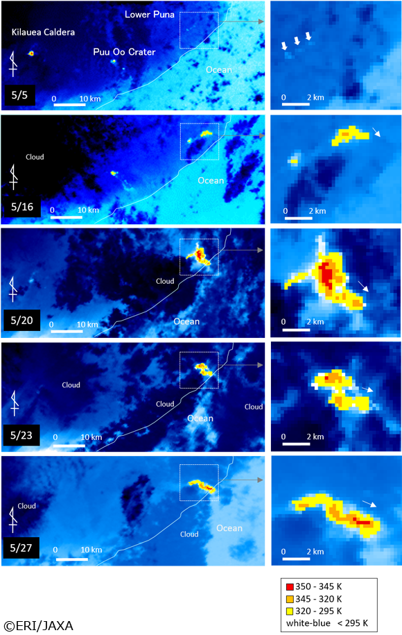
Fig. 2. Occurrences of the lava flow of Kilauea volcano in Hawaii, observed by “Shikisai” Images taken on May 5, 16, 20, 23, and 27, 2018 (brightness temperature images produced from the thermal infrared images with spatial resolution of 250 m. Temperature unit K: Kelvin = Celsius deg. C + 273.15). An enlarged image of the lower Puna district is shown on the right side.
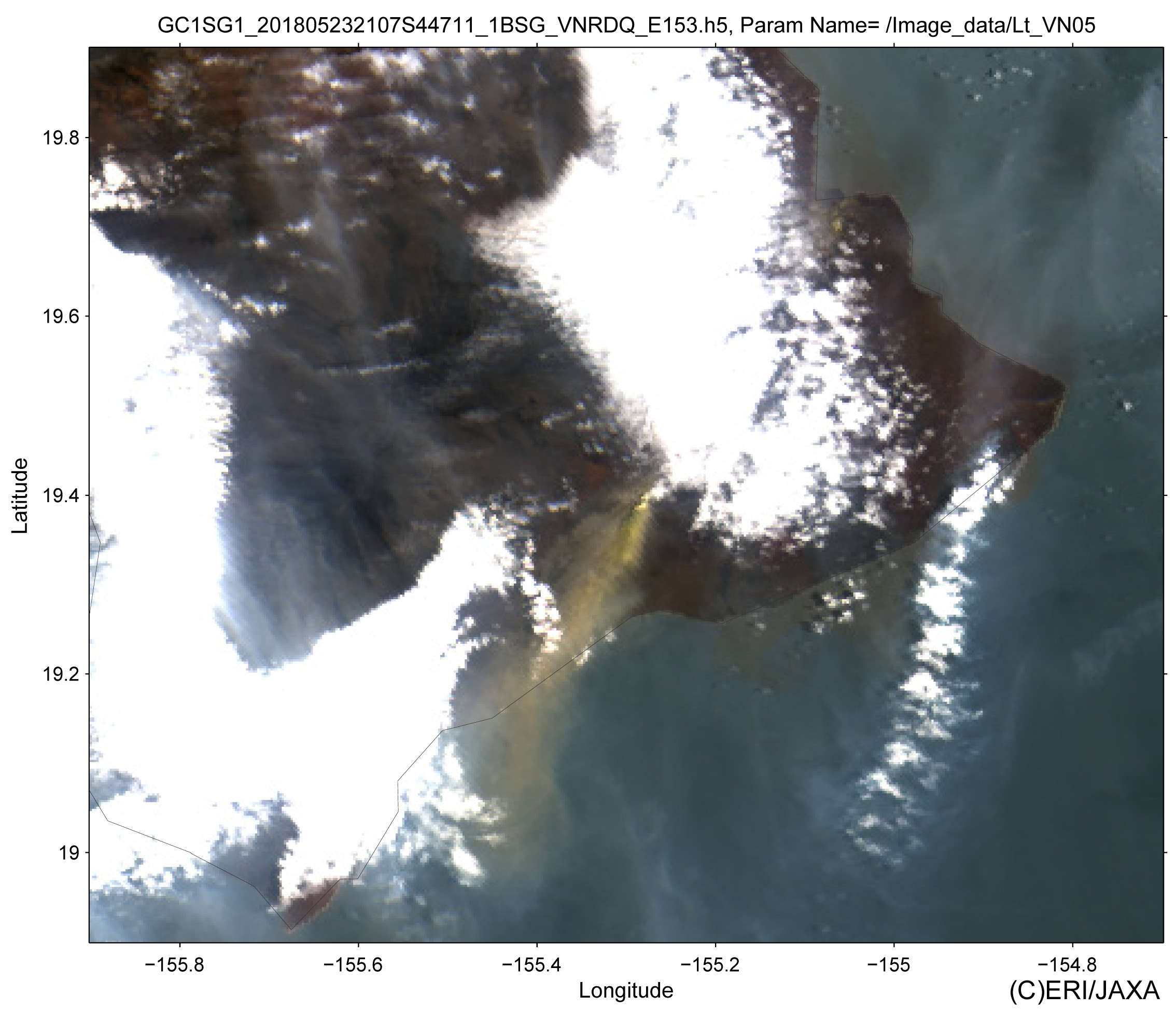
Fig. 3. A plume of Kilauea volcano in Hawaii, observed by “Shikisai”. An Image taken on May 23, 2018 (color composite image produced by allocating data of green, blue and near-ultraviolet wavelength data of 250-m spatial resolution to RGB)
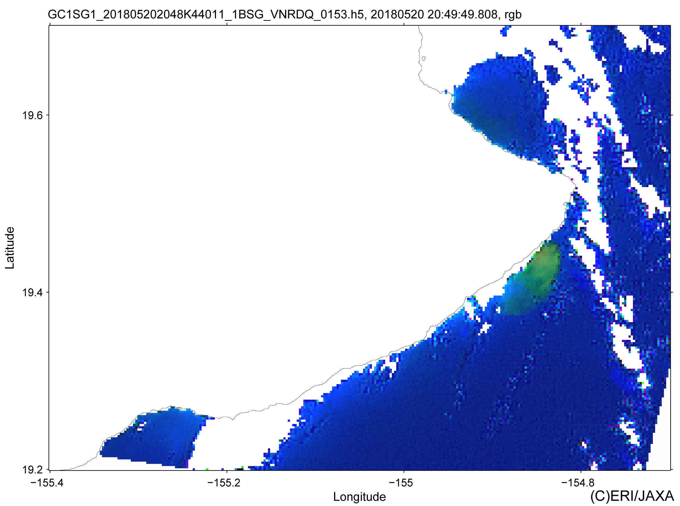
Fig. 4. Discolored water near Kilauea volcano in Hawaii, observed by “Shikisai”. An image taken on May 20, 2018 (color composite image which estimates the red, green and blue color of sea surface by correcting the influence of the atmosphere from the data of visible/near infrared wavelength of 250-m spatial resolution and allocated to RGB)
Kilauea volcano; a shield volcano with elevation of 1,247 m lying in the southeast part of Hawaii Island, is the most active volcano in Hawaii. In addition to eruptions on the summit, fissure eruptions frequently occurred along the East Rift Zone as well as the Southwest Rift Zone that extend from the summit. Due to the low viscosity of the lava, most eruptions are relatively quiet mainly with lava fountain and flow-out of the lava. The activity this time is considered as a part of the activity that started in the East Rift Zone in 1983.
(Author: Takayuki Kaneko, Earthquake Research Institute, The university of Tokyo, June 13, 2018)
Explanation of the Images
(Fig. 2,3,4)
| Satellite | Global Change Observation Mission – Climate “Shikisai” |
|---|---|
| Sensor | Second generation GLobal Imager(SGLI) |
| Date | May. 05, 2018 May. 16, 2018 May. 20, 2018 May. 23, 2018 May. 27, 2018(Fig. 2) May. 23, 2018(Fig. 3) May. 20, 2018(Fig. 4) |
Related Sites
Search by Year
Search by Categories


Tags
-
#Earthquake
-
#Land
-
#Satellite Data
-
#Aerosol
-
#Public Health
-
#GCOM-C
-
#Sea
-
#Atmosphere
-
#Ice
-
#Today's Earth
-
#Flood
-
#Water Cycle
-
#AW3D
-
#G-Portal
-
#EarthCARE
-
#Volcano
-
#Agriculture
-
#Himawari
-
#GHG
-
#GPM
-
#GOSAT
-
#Simulation
-
#GCOM-W
-
#Drought
-
#Fire
-
#Forest
-
#Cooperation
-
#Precipitation
-
#Typhoon
-
#DPR
-
#NEXRA
-
#ALOS
-
#GSMaP
-
#Climate Change
-
#Carbon Cycle
-
#API
-
#Humanities Sociology
-
#AMSR
-
#Land Use Land Cover
-
#Environmental issues
-
#Quick Report
-
#GOSAT-GW
Related Resources


Disaster Related Articles
-
 Disaster 2025.10.23 Thu ALOS-2 Observations of the Earthquakes in the Philippines
(Cebu Island and Mindanao Island) -
 Disaster 2025.04.04 Fri ALOS-2 Observation of the M7.7 Earthquake in Myanmar
 -
 Disaster 2024.09.09 Mon ALOS-2 Observation of the Oil Spill Caused by the Sinking of a Tanker in Manila Bay, Philippines
 -
 Disaster 2023.04.07 Fri ALOS-2 observation: Oil spill from sunken oil tanker off Mindoro Island, Philippines (follow-up report)
Stay Connected
