


Disaster
2017.09.19 Tue
Heavy rains and floods caused by Hurricane IRMA: Observations from GPM and ALOS-2
From late August to early September 2017, Hurricane IRMA caused severe damage along the U.S. Caribbean coast and neighboring countries. On September 5 (UTC, same below), the Dual-frequency Precipitation Radar (DPR) onboard the Global Precipitation Measurement (GPM) Core Observatory observed the 3D rainfall distribution. The synthetic aperture radar onboard ALOS-2, PALSAR-2, observed the Dominican Republic on September 8 and Florida on September 12.
Figure 1 shows the track of Hurricane IRMA. From September 6 to 8, maximum wind speeds of over 130 knots (approximately 67 meters per second) were recorded, causing serious damage in the Caribbean.
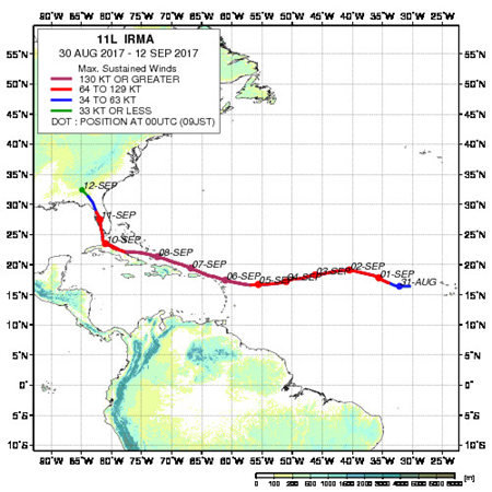
Figure 2 is an animation showing the three-dimensional structure of Hurricane IRMA observed by DPR onboard GPM Core Observatory at 16:00 on September 5, 2017. Heavy rain is falling in concentric circles around the center of the hurricane, while the eye is rainless, showing that the hurricane is well developed.
Figure 2. Three-dimensional structure of rainfall in Hurricane IRMA observed by GPM/DPR (16:00 on September 5, 2017)
(Left: observation time and location, right: observed rain distribution)
As shown above, after GPM/DPR observations were made, the hurricane moved westward from the Atlantic Ocean, causing severe damage along the Caribbean coast.
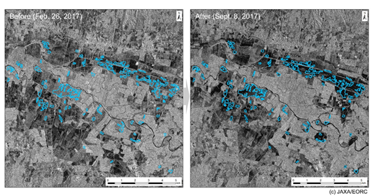
At the request of the International Charter ‘Space and Major Disasters’, JAXA is conducting observations of the Caribbean coastline using the PALSAR-2 onboard the ALOS-2. Analysis of a series of observational images allowed estimation of flooded areas likely caused by the heavy rains associated with the hurricane. Here we present an example from the Dominican Republic (Figure 3). A comparison of the images with past observational images revealed that many flooded areas were located in what appeared to be cultivated land along the river. This suggests that flooding damage was more prevalent inland than along the coast.
For other observations and details about ALOS-2, please see the ALOS Project page.
Explanation of the Images
Figure 2
| Satellite | Global Precipitation Measurement (GPM) Core Observatory |
|---|---|
| Sensor | Dual-frequency Precipitation Radar (DPR) |
| Date | September 15, 2017, around 16:00 (UTC) |
Figure 3
| Satellite | Advanced Land Observing Satellite-2 “DAICHI-2” (ALOS-2) |
|---|---|
| Sensor | L-band Synthetic Aperture Radar-2(PALSAR-2) |
| Date | February 26, 2017 (left)
September 8, 2017 (right) |
Related Sites
Search by Year
Search by Categories


Tags
-
#Earthquake
-
#Land
-
#Satellite Data
-
#Aerosol
-
#Public Health
-
#GCOM-C
-
#Sea
-
#Atmosphere
-
#Ice
-
#Today's Earth
-
#Flood
-
#Water Cycle
-
#AW3D
-
#G-Portal
-
#EarthCARE
-
#Volcano
-
#Agriculture
-
#Himawari
-
#GHG
-
#GPM
-
#GOSAT
-
#Simulation
-
#GCOM-W
-
#Drought
-
#Fire
-
#Forest
-
#Cooperation
-
#Precipitation
-
#Typhoon
-
#DPR
-
#NEXRA
-
#ALOS
-
#GSMaP
-
#Climate Change
-
#Carbon Cycle
-
#API
-
#Humanities Sociology
-
#AMSR
-
#Land Use Land Cover
-
#Environmental issues
-
#Quick Report
-
#GOSAT-GW
Related Resources


Disaster Related Articles
-
 Disaster 2025.10.23 Thu ALOS-2 Observations of the Earthquakes in the Philippines
(Cebu Island and Mindanao Island) -
 Disaster 2025.04.04 Fri ALOS-2 Observation of the M7.7 Earthquake in Myanmar
 -
 Disaster 2024.09.09 Mon ALOS-2 Observation of the Oil Spill Caused by the Sinking of a Tanker in Manila Bay, Philippines
 -
 Disaster 2023.04.07 Fri ALOS-2 observation: Oil spill from sunken oil tanker off Mindoro Island, Philippines (follow-up report)
Stay Connected
