
Disaster
2010.08.11 Wed
Forest Fires in Western and Central Russia under an Exceptional Heat Wave
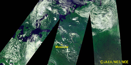
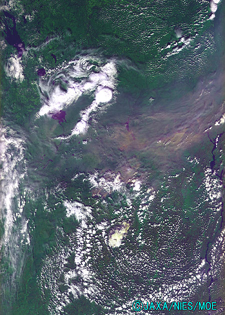
Figure 1 is an image of western and central Russia as observed by GOSAT (“Ibuki”) on July 24, 2010. Forests (dark green), grasslands, and croplands (light green) cover extensively the entire surface of the land. White shapes in the image are clouds.
Russia has suffered from an exceptional heat wave since July of this year. Without a good rain, forest fires have broken out in various places. According to the Ministry of Emergency Situations (The Ministry of the Russian Federation for Affairs of Civil Defense, Emergencies and Disasters Relief (MCHS)), forest fires have spread over 17 states and republics in Russia and expansion still threatens as of the end of July. The Russian authorities indicated that the causes of the fires are mostly careless handling of the embers of garbage burning, smoking, camp fires, and barbecuing, CNN reported.
The yellow mark in the middle of the image indicates Moscow. At Nizhniy Novgorod, an industrial city 400 km northeast of Moscow, visibility is worsening due to the inflow of fire smoke, and many people, especially children and the elderly, are said to be in bad condition.
In the forested area around Moscow, there are sediments of withered plants called “peat” in the soil and they are also burning. Fires of peat bed smolder in the ground and do not go out easily. Fire fighting is foreseen to last long and to be difficult.
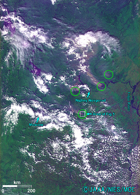
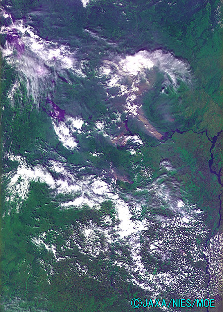
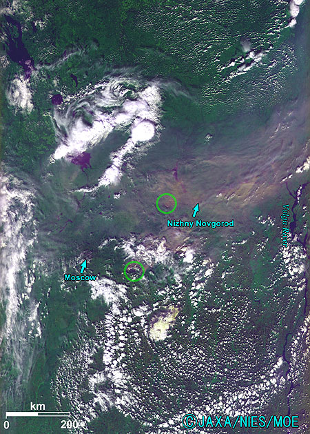
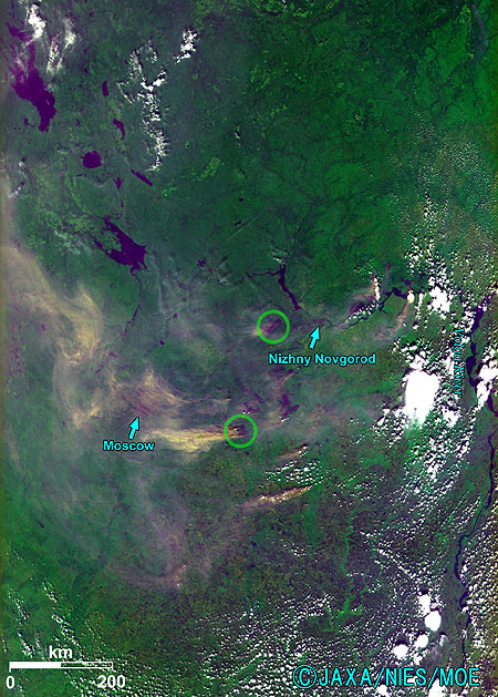
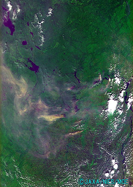
Figures 2 to 4 are enlarged images around Moscow as observed on July 27, August 2, and August 8. Forest fires are marked by green circles. Figure 2 shows forest fires near Nizhniy Novgorod and smoke flowing northwest. The white shapes are clouds and the streams of light brown or yellow are smoke from the fire. Figure 3 on August 2 shows the smoke from a big fire covering the city of Nizhniy Novgorod. Six days later, on August 8, the smoke reached Moscow (See Figure 4).
caption on
caption off
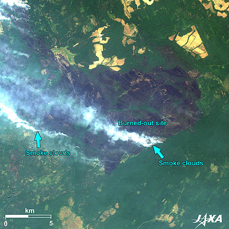
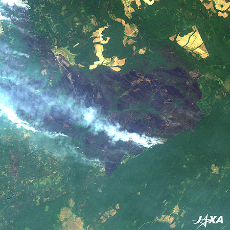
Fig. 5. Forest Fires in the South of Nizhniy Novgorod
Forest Fires in Russia (kmz, 4.40 MB, Low Resolution) as seen on Google Earth
Figure 5 shows forest fires in the south of Nizhniy Novgorod as observed by ALOS (”Daichi”) on July 28, 2010. The green areas of the image are forests, grasslands, and croplands. The dark portion in the center of the image is the burned-out site. Smoke clouds are rising from the southeast and southwest of the image. Forests are still ablaze in these areas.
In addition to the forest fires, a record heat wave brought with it serious drought. This is the worst dought in the last few decades in Russia. Due to the extent of damages related to the drought, the Prime Minister (Vladimir Vladimirovich) Putin has signed an edict to temporarily prohibit exportation of grain products, including wheat. Since Russia is a world-leading exporter of wheat, an international rise in the price of wheat is a matter of concern worldwide.
Explanation of the Images:

| Satellite: | Greenhouse Gases Observing Satellite (GOSAT) (“Ibuki”) |
| Sensor: | Thermal and Near Infrared Sensor for Carbon Observation-Cloud and Aerosol Imager (TANSO-CAI) |
| Date: |
July 27, 2010 (Figures 1 and 2) August 2, 2010 (Figure 3) August 8 (Figure 4) |
| Ground resolution: | 500 m |
TANSO-CAI is a remote sensor for observing clouds and aerosol and detecting error sources to determine the amount of greenhouse gases.
TANSO-CAI has four observation bands. Figures 1 to 4 are produced by assigning red to Band 2 (664 to 684 nm), green to Band 3 (860 to 880 nm), and blue to Band 1 (370 to 390 nm). The resulting images have natural coloring as if seen by the naked eye. The following colors designate ground objects:
| Dark green: | Forests |
| Light green or ocher: | Grass fields or farmland |
| Brown: | Bare ground |
| Blue: | Water |
| White: | Clouds |
| Satellite: | Advanced Land Observing Satellite (ALOS) (Daichi) |
| Sensor: | Advanced Visible and Near Infrared Radiometer-2 (AVNIR-2) |
| Date: | 0827 (UTC) on July 28, 2010 |
| Ground resolution: | 10 m |
| Map Projection: | Universal Transversal Mercator (UTM) |
AVNIR-2 has four observation bands. The color composite images are usually produced by assigning red to Band 3 (610 to 690 nm), green to Band 2 (520 to 600 nm), and blue to Band 1 (420 to 500 nm). The resulting images have natural coloring as if seen by the naked eye.
Related Sites
Greenhouse Gases Observing Satellite “IBUKI” (GOSAT)” First Thermal infrared spectra” Acquired
Search by Year
Search by Categories
Tags
-
#Earthquake
-
#Land
-
#Satellite Data
-
#Aerosol
-
#Public Health
-
#GCOM-C
-
#Sea
-
#Atmosphere
-
#Ice
-
#Today's Earth
-
#Flood
-
#Water Cycle
-
#AW3D
-
#G-Portal
-
#EarthCARE
-
#Volcano
-
#Agriculture
-
#Himawari
-
#GHG
-
#GPM
-
#GOSAT
-
#Simulation
-
#GCOM-W
-
#Drought
-
#Fire
-
#Forest
-
#Cooperation
-
#Precipitation
-
#Typhoon
-
#DPR
-
#NEXRA
-
#ALOS
-
#GSMaP
-
#Climate Change
-
#Carbon Cycle
-
#API
-
#Humanities Sociology
-
#AMSR
-
#Land Use Land Cover
-
#Environmental issues
-
#Quick Report
Related Resources
Disaster Related Articles
-
 Disaster 2025.10.23 Thu ALOS-2 Observations of the Earthquakes in the Philippines
(Cebu Island and Mindanao Island) -
 Disaster 2025.04.04 Fri ALOS-2 Observation of the M7.7 Earthquake in Myanmar
 -
 Disaster 2024.09.09 Mon ALOS-2 Observation of the Oil Spill Caused by the Sinking of a Tanker in Manila Bay, Philippines
 -
 Disaster 2023.04.07 Fri ALOS-2 observation: Oil spill from sunken oil tanker off Mindoro Island, Philippines (follow-up report)


