


JAXA conducts emergency satellite observations and provides satellite data and damage information identified by the data free of charge, not only for natural disasters in Japan, but also for natural disasters overseas. JAXA is a member of Sentinel Asia and the International Charter ‘Space and Major Disasters’. The following is an introduction to the activities of Sentinel Asia.
International Charter ‘Space and Major Disasters’
Purpose and Members
The International Charter ‘Space and Major Disasters’ is an international framework for disaster management, which aims to contribute to disaster monitoring, recovery and post-disaster management by providing Earth observation satellite data in the event of a major disaster. It was established in 2000 by the space agencies of Canada and Europe, and JAXA became a member in 2005. Currently, 17 agencies are joining, and the number of satellites that can provide emergency observation data is more than 60 (Figure 1, Table 1: as of April 2021).
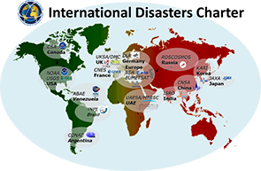
Figure 1: The International Charter ‘Space and Major Disasters’ members
List 1: Charter Members
| Charter Members (17 agencies) | Major satellite |
|
Agencia Bolivariana para Actividades Espaciales (ABAE):Venezuela |
VRSS-1 |
| VRSS-2 | |
| Centre National d’Etudes Spatiales (CNES) | Pleiades-1A/1B |
| SPOT-6/7 | |
| China National Space Administration (CNSA) | GF-1 |
| GF-2 | |
| GF-3 | |
| GF-4 | |
| The Argentine Space Agency (CONAE) | SAOCOM-1A/1B |
| Canadian Space Agency (CSA) | RADARSAT-2 |
| RCM 1, 2, 3 | |
| German Aerospace Center (DLR) | TerraSAR-X,TanDEM-X |
| European Space Agency (ESA) | Sentinel-1A/1B |
| Sentinel-2A/2B | |
| European Organisation for the Exploitation of Meteorological Satellites (EUMETSAT) | Metop-A/B/C |
| Meteosat Second Generation Series | |
| National Institute for Space Research (INPE) | CBERS-4(Joint development with China) |
| CBERS-4A(ditto) | |
| Indian Space Research Organisation (ISRO) | Cartosat-2/2A/2B |
| Resourcesat-2/2A | |
| Japan Aerospace Exploration Agency (JAXA) | ALOS-2 |
| HDTV-EF2(ISS Kibo) | |
| Korea Aerospace Research Institute (KARI) | KOMPSAT-2 |
| KOMPSAT-3 | |
| KOMPSAT-3A | |
| KOMPSAT-5 | |
| National Oceanic and Atmospheric Administration (NOAA) | NOAA-18/19, Metop-A/B/C |
| NOAA-20, Suomi NPP | |
| GOES-16/17 | |
| The State Space Corporation (ROSCOSMOS) | Kanopus-V 3, 4, 5, 6 |
| Kanopus-V-IK | |
| Meteor-M 1, 2, 2.2 | |
| Resurs-P 1, 3 | |
| UAE Space Agency (UAESA) and Mohammed Bin Rashid Space Centre (MBRSC) | DubaiSat-2 |
| KhalifaSat | |
| UK Space Agency and DMC International Imaging (DMCii) | ALSAT-1B |
| UK-DMC-2 | |
| Vision-1 | |
| United States Geological Survey (USGS) | Landsat7/8 |
| WorldView-1/2/3 | |
| GeoEye-1 |
| Private data provider | Major satellite |
| US Planet Labs Inc. | PlanetScope constellation |
| Finland ICEYE | ICEYE-X2, X3, X4, X5, X6, X7 |
Characteristics
Space agencies from all over the world are participating in the International Charter ‘Space and Major Disasters’. Therefore, even in cases where a country’s own satellites are unable to make timely observations, or in cases where a disaster is so extensive that the full extent of the damage cannot be seen, it is possible to obtain supplementary information by the cooperation of the world’s space agencies of Charter members.
In addition to space agencies, private data providers are also cooperating to provide satellite images free of charge. Planet Labs, a U.S. company operating small optical observation satellites, become a private data provider in 2018 and ICEYE, a Finnish company operating a small radar observation satellite constellation, joined in 2020.
Examples of Results
The torrential rain of July 2018 caused record-breaking heavy rainfall over a wide area nationwide, mainly in western Japan, from June 28, 2018, resulting in extensive damage in many areas. We would like to express our deepest sympathies to the victims of the disaster.
For this disaster, we not only requested emergency observations by the Advanced Land Observing Satellite-2 (ALOS-2), but also requested assistance from the International Charter ‘Space and Major Disasters’ and Sentinel Asia. Satellite images were provided by the Charter Members including DLR, CNES, USGS, ROSCOSMOS, KARI, ESA, UKSA/DMCii, CNSA, and MBRSC, and from several organizations of Sentinel Asia.
Figure 2 shows an flood detection map of the area around Kurashiki City, Okayama Prefecture, created by the Center for Research and Application for Satellite Remote Sensing, Yamaguchi University based on Pleiades-1A images provided by the French National Space Research Center (CNES) and JASA’s ALOS-2 images. Many other information obtained from the satellite images were provided to the Cabinet Office and other organizations related to disaster management.
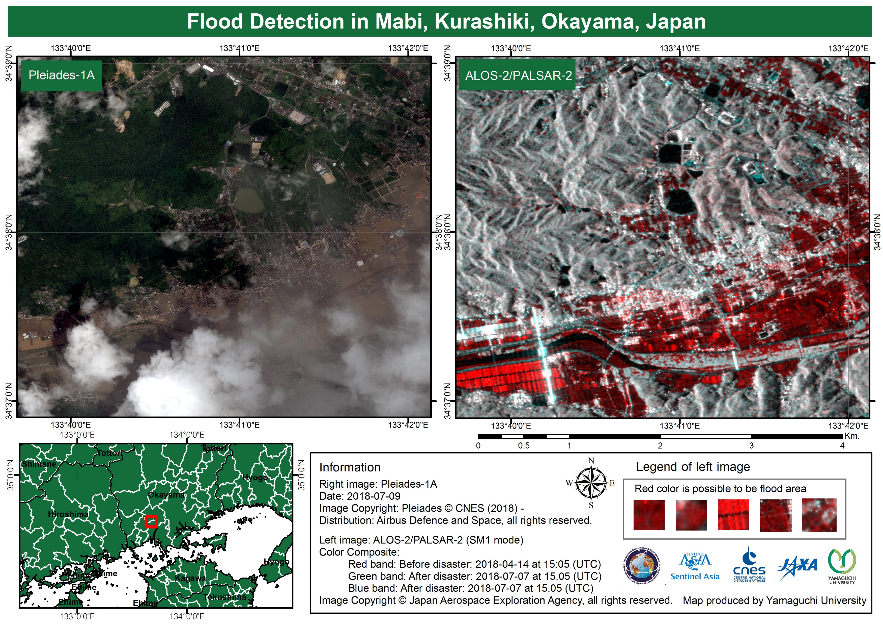
Figure 2: Flood detection map provided by Yamaguchi University
JAXA Response by International Charter ‘Space and Major Disasters’
April 2015: ALOS-2 Observation Results of the Nepal Earthquake
July 2015: ALOS-2 Observation Result of Flood Damage in Myanmar
September 2017: ALOS-2 Observation Result of Hurricane Damage in the Caribbean
June 2018: ALOS-2 Observation Result of the Eruption of Mount Fuego in Guatemala
August 2020: ALOS-2 Observations of the Oil Spill on the Coast of Mauritius


Stay Connected
