JAXA conducts emergency satellite observations and provides satellite data and damage information identified by the data free of charge, not only for natural disasters in Japan, but also for natural disasters overseas upon request from disaster management organizations in the affected countries. JAXA is a member of Sentinel Asia and the International Charter ‘Space and Major Disasters’. The following is an introduction to the activities of Sentinel Asia.
Read the introduction about the International Charter ‘Space and Major Disasters’
Purpose and Members
Sentinel Asia is an international cooperative project that aims to contribute to disaster management in the Asia Pacific region by utilizing space technology. The purpose is to reduce the damage caused by natural disasters by sharing disaster-related information, such as Earth observation satellite images, via Internet. It was launched in 2006 as an initiative of the Asia-Pacific Regional Space Agency Forum (APRSAF), with JAXA playing a central role.
In Sentinel Asia, JAXA plays a central role in the overall operation as the executive secretariat, together with the Asian Disaster Reduction Center (ADRC), which serves as the contact point for requests for emergency observation support. Currently, there are 111 member organizations (as of April 2021). The organizations participating in Sentinel Asia are divided into four categories, and respond to natural disasters through cooperation and collaboration by making the most of their respective characteristics.
Categories
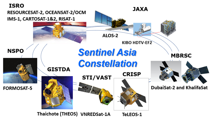
1. Space agency: Provision of Earth observation satellite images (Data Provider Node: DPN) (Figure 1)
2. Analysis Support Organization: Analysis of Earth observation satellite images provided by space agencies and provision of damage information. Data Analysis Node (DAN),
3. International organizations
4.Disaster management agency of each country
Zoom
Figure 1:Emergency observation support satellites for Sentinel Asia (as of April 2021)
Characteristics
Sentinel Asia is characterized by the participation of not only space agencies such as JAXA, which provide satellite data, but also research institutes, which analyze satellite data to provide information on damage, and disaster management organizations, which use the provided data and information for disaster management activities. Therefore, in addition to providing satellite data and information obtained through analysis, Sentinel Asia also provides technical cooperation to support the dissemination of information related to disaster management, and capacity building (capacity development for satellite data analysis technology and utilization scenario building). Another characteristic is that they have regular opportunities for members to communicate with each other, and they can get direct feedback from disaster management agencies that actually use the data on the information provided by space agencies and research institutes and how they provide it. By reflecting user needs and continuing to make improvements, Sentinel Asia aims to provide the information and technology needed by users at the right time, rather than providing information unilaterally.
Escalation to the International Charter ‘Space and Major Disasters’
Sentinel Asia members can also activate the International Charter ‘Space and Major Disasters’ according to the scale of damage when Sentinel Asia is activated. The Sentinel Asia Escalation mechanism will allow Sentinel Asia member organizations in Japan and other Asia-Pacific countries and regions to use emergency observation data from various overseas satellites through the International Charter ‘Space and Major Disasters’.
Examples of Results
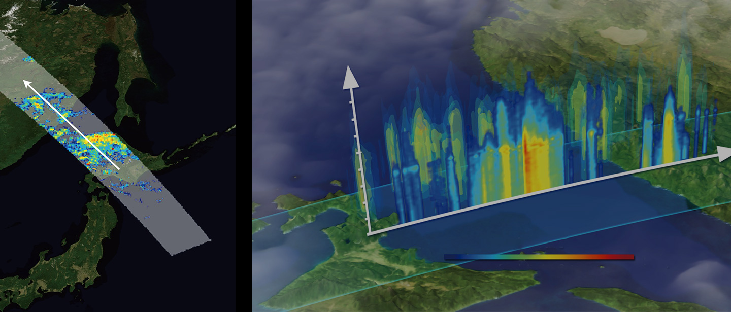
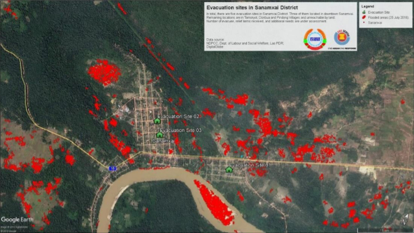
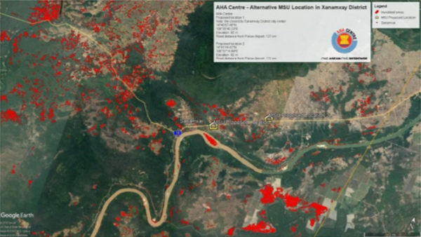
On July 23, 2018, the Xepian-Xe Nam Noy hydropower plant dam in southern Laos broke collapsed, which caused flooding villages downstream due to water flown from the storage reservoir. We would like to express our deepest sympathies to the victims of the disaster. In response to a request from the Department of Social Welfare (DSW) of the Ministry of Social Welfare, Relief and Resettlement of Laos, the Asian Disaster Preparedness Center (ADPC)sent a request for emergency observation support to Sentinel Asia on July 24. JAXA conducted emergency observations by ALOS-2 on July 26 and 27. The Indian Space Research Organization (ISRO) also provided Resourcesat-2A image on July 26. These emergency observation images were analyzed by ADPC, Asian Institute of Technology (AIT),Center for Research and Application for Satellite Remote Sensing, Yamaguchi University and International Water Management Institute (IWMI), and inundation area maps are provided. This information was used by the ASEAN Coordinating Centre for Humanitarian Assistance on disaster management (AHA Centre) to make decisions on where to set up evacuation sites and where to deploy relief supplies provided by ASEAN (Figure 2).
Zoom
Zoom
Figure 2: Locations of evacuation sites (left) and deployment of relief supplies (right) determined by the AHA Centre based on inundation area maps provided by Sentinel Asia DAN.
This outcome was explicitly reported in「the ASEAN RISK MONITORING AND DISASTER MANAGEMENT REVIEW (ARMOR)」, a policy communication document published by the AHA Centre in March 2019 (Figure 3). In the ARMOR, the importance of Sentinel Asia was emphasized and a recommendation was made that the disaster management agencies of all ASEA member countries should utilize Sentinel Asia.
Zoom
Figure 3: ARMOR issued by AHA Centre
JAXA response by Sentinel Asia
The Nepal Earthquake in April 2015 The West Bhutan Glacial Lake Outburst Flood in June 2016 The Myanmar Heavy Rain in July 2016 The Taiwan Earthquake in February 2018 The Laos Flood in July 2018 The Myanmar Flood in August 2018 The Indonesia Earthquake in September 2018 The Philippine Volcanic Eruption in January 2020
Future efforts
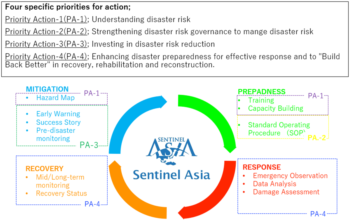
When Sentinel Asia was first launched, it focused on “Response,” including emergency and rescue operations immediately after a disaster. However, since 2013, it has been working on activities related to “Prevention/Mitigation”, “Preparedness”, and “Rehabilitation/Reconstruction” as well. aiming to provide more effective disaster management support by approaching the entire disaster management cycle. The Sendai Framework for Disaster Risk Reduction, an international guideline for disaster reduction, was established through the Third United Nations World Conference on Disaster Risk Reduction held in Sendai City, Miyagi Prefecture in March 2015. Based on this, Sentinel Asia has formulated a long-term strategic plan that links Sentinel Asia’s activities with the Sendai Framework for Disaster Risk Reduction and set more specific targets for the activities (Figure 4).
Zoom
Figure 4: Activity Objectives for All Hazard Management Cycle Response between Sendai Framework for Disaster Risk Reduction and Sentinel Asia
Currently, Sentinel Asia is conducting regular simulator trainings for requesting an emergency observation to Sentinel Asia, and developing a “Standard procedure manual” with the aim of establishing a systematic approach to promptly requesting an emergency observation to Sentinel Asia in cooperation with related organizations in each country in the event of a disaster. Under these circumstances, the international recognition of Sentinel Asia has been increasing, as a paper contributed by the Sentinel Asia community was adopted in the Global Assessment Report (GAR) published by the United Nations Disaster Reduction Agency (UNDRR). JAXA, as the executive secretariat of Sentinel Asia, will continue to deepen and revitalize community cooperation and work with member organizations to make Sentinel Asia a more established tool for disaster management in disaster-stricken countries.