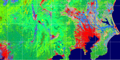

| Description | This site provides land use and land cover map in Japan based on the data observed by ALOS. |
| URL | https://www.eorc.jaxa.jp/ALOS/en/dataset/lulc_e.htm |
| Research Field | Land, Land cover |
| Application | Land management, City planning, Agriculture |
| Product | Land use Land cover map |
| Format | GeoTIFF |
| Area | Around Japan, Vietnam |
| Period | 2006 – now |
| Spatial Resolution | 10m – 50m |
| Temporal Resolution | Every year |
| Terms of Use | This policy is applied. Additionally, not specified items are confirmed to this policy. |
| Tags | Land, DAICHI (ALOS), Agriculture, Infrastructure, Around Japan, Yearly, Download, High Resolution, Commercial Use Allowed (Free of charge) |